U.S. 66 in Oklahoma City - Page 2
Index to this page
More OKC information on Page 1
The Three Beltline 66 alignments
The "Beltline" was in fact a bypass alignment around the city so that through traffic could avoid driving along the congested city streets.
There were different Beltline alignments over the years. They all split from the main alignment south of Edmond and met the City alignment again, on the NW side of OKC.
Coming from Edmond southbound along US 66 (N Kelly Ave), the "Beltline" split from the "City" US 66 on E. Britton Road, turning westwards along it and heading towards the town of Britton.
This was the route taken by Rittenhouse in 1946. Below are the three alignments that US 66 "Beltline" followed over the years:
- 1931-36 Britton Rd. and Western Ave. and 39th.
Map with directions - 1936-53 Britton Rd. and Western Ave., Classen and 39th.
Map with directions - 1947-53 Britton Rd. and May Ave., a second Beltline in addition to the older one.
Map with directions
1953: Beltline was eliminated.
Sponsored content
Sights along the Beltline
The first attraction is almost 2 miles west, past US 77; it is an Old Motel to your left on the SE corner of W Britton and N Cassen Blvd.
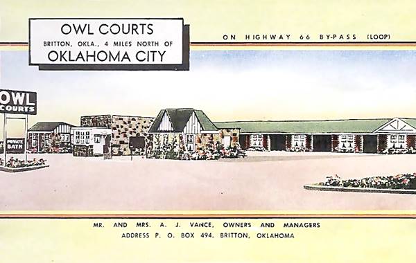
Owl Courts Motel
742 W Britton Rd, Oklahoma City,
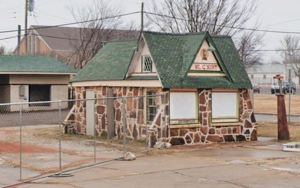
The Owl Courts (Motel) mentioned by Rittenhouse, was built back in the early 1930s on the brand new Beltline. It included a gas station and a Cafe and remained in operation until the 1970s. Now it is abandoned and in disrepair.
Owl Courts Motel today in Oklahoma City, Oklahoma
To your right, facing Owl Courts is Tom's Tire Center (801 W Britton Rd), a former gas station now a tire shop (Street view). Continue west and as you enter the town of Britton, you will see more attractions.
Britton
Britton, Oklahoma used to be a town in Oklahoma County, Oklahoma, but now it is a neighborhood which is part of Oklahoma City.
Former Sinclair Filling station
901 W Britton Rd, Oklahoma City
To your right on the NW corner of Britton and Francis Ave. is Penn Auto Glass, which used to be a Sinclair gas station from the 1930s (now lacking the solid "table-shaped" canopy ; see Route 66, Tulsa Sinclair station with a canopy).

Across the street, on the south side, is a Classic Movie Theater:
Ritz Theater
912 W. Britton Road, Oklahoma City
The first Ritz was built on the north side of the road in 1922, then (1930s?) a second one (pictured below) was built on the south side, with twice the capacity (586 seats). It was the "New Ritz", it closed and reopened over the years.
Don't miss the Britton mural with its Route 66 shield painted on the brick wall.
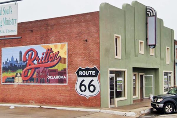
Just ahead, at the grade crossing of the railroad, the Beltline turned south from 1931 to 1953, along North Western Ave. The additional Beltline along North May Ave from 1947 to 1953 lies ahead, straight along W. Britton Rd. So we will describe both of them:
Click on the images below for their Steet view
Beltline on May Ave. (1947-53)
This 1947-53 has only one landmark worth seeing and it is very near, only 3 blocks west of the railroad crossing:
1960s Service Station
1401 W Britton Rd, Oklahoma City
Ahead, to your right is this gas station with a very 1960s sawtooth canopy. West of this point there are no other attractions. Turn back and turn south along N Western Ave.
Beltline along N Western Ave. (1931 - 53)
Turn south (left) along N Western Ave. And three blocks south, to the left is a Trading Post.
Western Trail Trading Post
9100 N Western Ave, Oklahoma City
This music store pictured above, used to be a "Western" Trading Post where city slicker tourists could by native art and handicrafts. Don't miss the two totem poles in the yard.
Crossing the NW 90th street also to your left is a Classic Restaurant, now closed, but its building still standing:
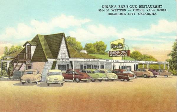
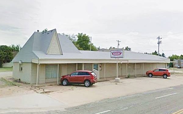
Dinah’s Bar-B-Que Restaurant
9014 N Western Ave, Oklahoma City
Now it is "Baker's Printing Co" and the old neon sign has gone, but the building is unchanged.
Dinah’s Bar-B-Que Restaurant 1950s postcard in Oklahoma City, Oklahoma
Continue southbound, and after half a mile, to your right is a 1960s drive-in.
Former Mr. Swiss
8301 N Western Ave, Oklahoma City
To your right, at the Goodwill Donation Center, is a red roofed A-frame building that used to be a "Mr. Swiss" hamburger drive-in, a chain founded by L. Doefler in 1964, here in Oklahoma City. It sold burgers, ice cream and sandwiches.
It grew to have almost 200 stores across the US, folding in the 1970s. There are more Mr. Swiss on US 66: in Lebanon MO, Claremore OK and Joplin MO.
Continue south for 1.9 miles, and when you reach I-44, you will get to the spot where the 1936 - 53 Beltline forked off to the left along N Classen Blvd. Now the area has been drastically modifed due to the presence of the freeway. Below we will describe this alignment, but now keep straight along the 1931 - 1936 N Western alignment. Cross the freeway and 0.8 mi. ahead, to your left is another Old Theater:
Will Rogers Theatre
4322 N Western Ave, Oklahoma City
It was built after WWII, opening in 1946. It could sit 1,000 viewers and was decorated with murals, which have survived. The theater is now an event center with a Lobby Cafe and Bar, Sushi, Japanese Steakhouse and The Coach House Restaurant. See its original appearance in this 1950s photo.
Just 0.3 miles ahead is where this "Beltline 66" met the "City 66" while it was aligned along N Western, and both merged here into US 66, heading west along NW 39th Street. The end of this Beltline. Now head back to the freeway to visit the later "North Classen Blvd. Alignment":

1936 - 53 Beltline Variant along N Classen Blvd.
Route 66 used the alignment described above, along N Western until 1936. After that date it forked west, along Classen Blvd. to 39th Street where it met the City 66 alignment.
This area between N Western Ave. and I-44 in the north and Classen Blvd and NW 50th St. has changed considerably over the years.
The 1948 Shell roadmap below, shows N Western Ave on the right side, and, after crossing the Deep Fork River, Classen Blvd. branches off to the left with a NE-SW course, turning south again at NW 50th Street. Belle Isle Lake lies just west of it.
Three years later, the USGS map (1951) shows the new freeway under construction; it was the western extension of Grand Blvd. and it coincides with modern I-44 to the east of N Western Ave.
West of this point Route 66 continued along Classen to a circle or roundabout between 50th and 49ths Streets. There was no Northwest Expwy at that time and the land west of N. Georgia Ave was open countryside; and that is why I-44 was later built there.
This is a Google Map showing Classen Circle today.

1948 Shell road map, Oklahoma City. David Rumsey

1951 USGS map, Oklahoma City
1954 brought more changes.
The aerial photograph from 1954 shows more changes: the NW expressway has been built and meets the roundabout from the west, the freeway from the east has been finished and what is now I-44 is being built south of the NW expressway (from present Exit 125 B) up to Altadena Ave.
This would change later when Bell Island Lake was filled in and I-44 was completed between N. Western and Exit 125 B, running in an arch around former Classen Circle, acquiring its present configuration.
The "Circle" no longer exists as a roundabout, though it remains in the street's name. There is a classic building is still standing next to it.
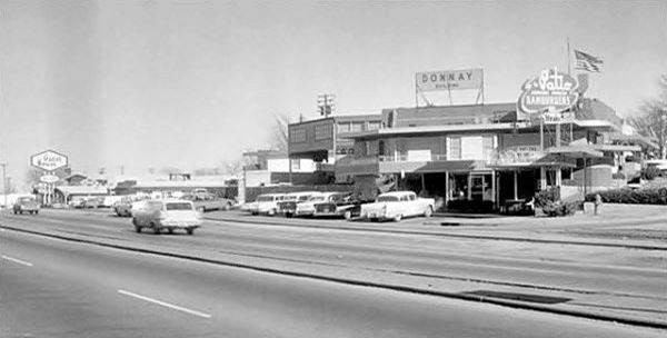
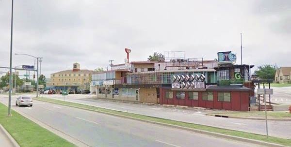
Donnay Building
Classen Circle and NW 50th St. OKC
The Donnay building was built in the late 1940s and during 2017 was at risk when Braum's petitioned the City Council to have the triangular block rezoned. It wanted to raze the buildings on it and construct a new drive-through store. The neighbors opposed and the Council put the request on hold. Braum's then withdrew it but the owner of the property has said that if it is not sold to Braum's, the Donnay Building will still be demolished.
Now it has five different tenants. Hilo bar is one of them. In the past it was "The Patio" restaurant. Below is a "Now and Then" sequence of this property on Route 66:
This is the end of the "Classen" Beltline (1936-53) and our description of all the Beltline alignments. You can drive west from here, towards Bethany, for more attractions.
US 66 West of OKC towards Yukon
It is a 20.4 mile drive. See this Map with Directions.
Head west along I-44 and switch to the NW 39th Expressway all the way to Mariner Dr. Here take a left leaving the expressway and take a right at N Overholser Dr., the road will take you after 2.5 miles to the Route 66 Park.
Route 66 Park
9901 NW 23rd St
It includes a watchtower, an amphitheatre and for Route 66 fans, a scaled down walkable version of Route 66 from Chicago to Los Angeles with seals for the most important towns along the road.
It is Open daily and admission is free.
Retrace your steps and at the eastern tip of Overholser Lake is the Historic Bridge:
Lake Overholser Bridge

Overholser Bridge, Route 66.
Listed in the National Register of Historic Places
It is part of OKC, though it is nearer Yukon. Street View.
It combines two kinds of steel trusses: each end is a camelback Warren Pony Truss while the four central spans are Parker Through Trusses. It was built between 1924 and 1925, predating Route 66 which later incorporated it into its alignment for over three decades.
It was rehauled in 2001 and reopened to local vehicular traffic once again.
Now drive eastwards towards the city and drive through the town of Bethany.
Bethany
Elevation: 1,309 ft (399 m). Population: 19,051 (2010).
This city in Oklahoma County was founded in 1909 by followers of the Church of the Nazarene from Oklahoma City. It had "blue laws" banning alcohol, dancing, tobacco, movies and working on Sundays, which have been relaxed since then.
There is plenty to see there.
> > Read all about Bethany
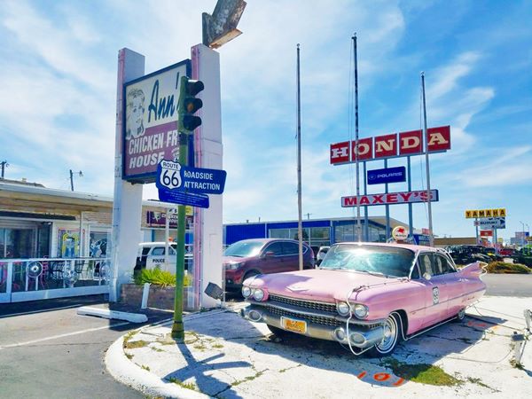
Continue east and at N. St. Mary's street stop for a bite at Ann's Chicken Fry House.
Ann's Chicken Fry House
4106 NW 39th St. OKC
Route 66 Roadside Attraction
It opened in 1948 as a Cities Service gas station. Later it became Coronado Inn and in 1966 it was the "Three Bull's Steakhouse".
Two brothers, Alvin and Jerry Burchett bought it in 1971 and turned it into a "nostalgic" themed restaurant that serves comfort dishes.
Keep eastbound and leave the Expressway at St. Claire Ave., turn left to see a Route 66 Motel.
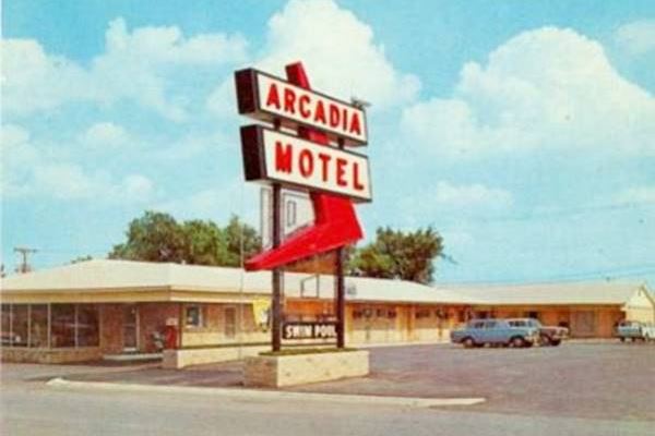
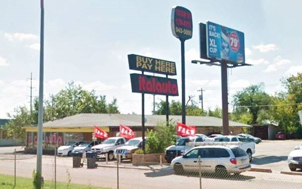
Arcadia Motel
3520 NW 39th
The empty lot to the right, was the site of the now razed Nuhoma Motel (Gone).
The old motel's postcard tells us that it had "Pool - TV- Restaurant", it is relatively unchanged (The "L" layot has changed, as the foot of the L has gone), and its old neon sign is still in use except for the red arrow, which has gone. It is now a used car lot, "Italauto". Below is a "Then and Now" sequence:
Just ahead, to the east is the interchange where I-44 curves south and both 39th St. Expressway and State Highway 3 branch off westwards and northwards respectively. Follow the frontage road up to NW 36th St. where you can cross I-44. Turn north along the frontage road (W I 44 Service Road). It curves around the site of the now razed (2017) Suntide Motel (Gone), but ahead is another survivor, the Tower Motel:
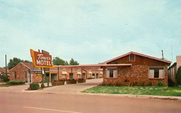
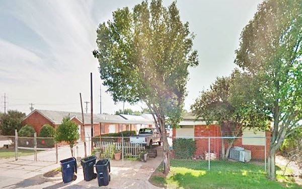
Tower Motel
3126 NW 39th Oklahoma City
This motel with a "U" shaped layout figures in the 1957 guide of Oklahoma City Hotels and Motels. The brick units with gabled roofs and the office to the right with its flat roof canopy are still there. Below is a "Then and Now" photo sequence:
Your Route 66 sightseeing tour ends here. You can visit some of the town's sights and landmarks.
Other Attractions in Oklahoma City
Route 66 in Oklahoma City
According to the Oklahoma DOT, these were the "official alignments of US 66 in Oklahoma City:
US 66 into OKC from the east:
- 1926-54: Into Edmond on E 2nd St (OK-66 & US 77), south from Edmond along S Broadway and Kelley to present I-44 (then Grand Blvd.) to Lincoln, and from there into the city, turning west on 23rd St.
Map with directions - 1954-79: Into Edmond on E 2nd St and south on former Sooner Rd. (now I-35) and along modern I-44 & I-35 to Lincoln, where Bus. 66 followed the previous alignment.
The main alignment continued along modern I-44 to N May, where it met westbound Bus. 66
Map with directions
The different alignments of City 66 west of the State Capitol:
- 1926-30: Along 23rd to Classen to 39th St.
Map with directions - 1930-33: Along 23rd to Western to 39th St.
Map with directions - 1933-54: Along 23rd to May Ave. to 39th St.
Map with directions - 1933-53: Western from 23rd to to 39th St. and west to May Ave. became Alt 66
- 1954-79: Along 23rd to May Ave. to 39th St. became Bus. 66 as the City 66 was eliminated.
- 03.05.1979 US 66 Business Route deleted in Oklahoma City
Beltline 66 alignments
Coming from Edmond southbound: (Green Line in Google map)
- 1931-36 Britton Rd. and Western Ave. and 39th.
Map with directions - 1936-53 Britton Rd. and Western Ave., Classen and 39th.
Map with directions - 1947-53 Britton Rd. and May Ave., a second Beltline in addition to the older one.
Map with directions - 1953: Beltline was deleted
Main US 66 west of Lincoln Ave.
- 1954-55 Grand Blvd (now I-44) to Classen, to N.W. Expressway to May Ave. to 39th.
Map with directions - 1955-76 Grand Blvd (now I-44) to Classen, to N.W. Expressway to May Ave. to what now is I-44 to 39th.
Map with directions - 1976-85 Modern I-44.
Map with directions
The end of US 66
04.01.1985: US 66 Designation removed across state
Oklahoma City National Memorial & Museum
620 N Harvey Ave, Oklahoma City

Oklahoma City National Memorial and Museum
We come here to remember those who were killed, those who survived and those changed forever. May all who leave here know the impact of violence. May this memorial offer comfort, strength, peace, hope and serenity. Phrase at the Memorial
The Federal Building in Oklahoma City was blown up in a domestic terrorist attack perpetraded on April 19, 1995 by Timothy McVeigh and Terry Nichols. 168 people were killed and over 680 more were wounded. The attack caused over $650 million in damage. Tried and convicted, McVeigh was executed in 2001, and Nichols was sentenced to life in prison.
The National Park Service memorial was dedicated in 2000, and includes a reflecting pool with two gates and a field with empty chairs made from stone and brass, symbolizing the victims.
Now, a less tragic sight, some vintage gas stations nearby (though not related to Route 66):
Two old gas stations
520 N Walker Ave
This station was built in the 1920s, and was a Wirt Frankling station. This is its street view; it has been restored.
Main and 101 N Western Ave
See its street view. Built in the 1930s it was a Deep Rock brand. It has also been recently renovated.
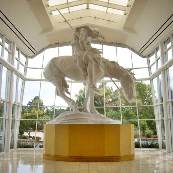
National Cowboy & Western Heritage Museum
1700 NE 63rd St, Oklahoma City
Located on the NE side of the city (location map). You can reach it easily by taking Exit 149 on I-44 or, if you are driving south into Oklahoma City from Edmond, take a left from N Kelly onto NE 63rd St. it is just straight ahead to your right.
Full details at their website: nationalcowboymuseum.org. There is an admission fee. Founded in 1955 it preserves a collection of Western art and artifacts, including galleries on Native Americans, their culture, American cobowys, historic gear, firearms and artifacts.
Go to these attractions on the Previous Page
In the Previous Page you'll find downtown Oklahoma City's Route 66 attractions and an overview of the city:
Some sponsored content
>> Book your Hotel in Tulsa

Credits
Banner image: Hackberry General Store, Hackberry, Arizona by Perla Eichenblat


