Historic Route 66 in Oklahoma
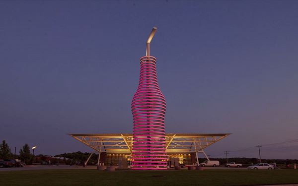
Futuristic and Modern design at the Pop66 Restaurant, Arcadia
Index to this page
About Arcadia, Oklahoma
Facts, Trivia and useful information
Elevation: 972 ft. (295 m). Population: 175 (2024).
Time zone: Central (CST): UTC minus 6 hours. Summer (DST) CDT (UTC-5).
Arcadia is just 20 miles northeast of Oklahoma City, in the eastern part of Oklahoma County and is also a part of the Oklahoma City Metropolitan Area. Its Motto is: "Unity - Pride - Commitment".
Oklahoma has been inhabited for over ten thousand years. Paleo Indians later evolved into the contemporary Native Americans, but the current mix of Indians in Oklahoma was due to the resettlement of those living East of the Mississippi River by the U.S. goverment during the first half of the nineteenth century. During that period natives from Alabam, Ohio, Illinois, Florida and Georgia were relocated in the Indian Territory and granted land in exchange for their original homelands.
Later the policy changed and the government reassigned the land to individual tribal members buying back any surplus lots. These were then lumped together as "open" land and granted to new "European" settlers.
The name, Arcadia
The first settlers found the region's calm and peaceful nature fitting with the Greek region of Arcadia, famous as a synonym for harmony with nature, unspoiled land with
natural splendor a garden of Eden.
Arcadia, from the Greek Arkadia is a mountainous region in Greece, named after Arkas, its first ruler and founder, a son of the Greek god Zeus.
It was the home of shepherds, simple, rustic and devoid of crime and ambition.
The homesteaders claimed their lots by the "Land Rush" or "Land Run" system by which those interested in staking a claim for a plot of land set off from a starting point and rode itno the land being "opended" to settlers which was staked out on a "first come, first served basis". There were several "runs" in the early 1890s in Oklahoma.
What would become Arcadia was assigned in the 1889 Land Run. The fertile farm land near the Deep Fork River attracted many farmers both white and African American.
A post office opened in 1890 with Sarah J. Newkirk as postmistress. In 1902 the Missouri, Kansas and Texas Railroad built a line linking Bartlesville with Oklahoma City which led the local farmer William H. Odor (the builder of the historic round Barn) to donate part of his land for a township to be established in March 1903. Benjamin and Sarha Newkirk followed his example and added land of their own in April 1903. Arcadia was born.
The railway station allowed cotton and farm goods to reach the markets and Arcadia grew: by 1907, when Oklahoma became a state, it had 994 residents.
A fire devastated the downtown area in 1924 razing the business district, however one building survived: Historic Tuton's Drugstore.
Route 66 was aligned through the town in 1926 and this increased local revenue as the locals catered to the travelers. The original Route 66 roadbed east of town is listed in the National Register of Historic Places.
The Great Depression was a hard period in Arcadia and workers moved to the larger towns seeking jobs. During the early 1950s, the Turner Turnpike replaced US Highwyay 66 between Oklahoma City and Tulsa as a safer and quicker route. This wiped out local business in Arcadia.
In 1974 heavy rains flooded the area and damaged the railroad tracks. Train service stopped for good after that. In 1983 the town began working towards incorporation (to avoid being absorbed by Edmond) and was recognized as such in 1987. Today many locals commute to work at Oklahoma City.
Trivia
Did you know that there is another town on Route 66 with the same name? Yes, Arcadia, but in California.
Getting to Arcadia
Heading east from Arcadia down Route 66 are the towns of: Luther (8 mi), Wellston (16 mi.), Warwick (20 mi.) and Chandler (29 mi.) To the west, are Edmond (9 mi.) and Oklahoma City (28 mi.)

Hotels in Arcadia
Where to Stay
Book your hotel in nearby Edmond or in Chandler
> > Book your Hotel in Edmond (9 mi.)
There are several hotels in the area close to this town. Alternatively you can also find your accommodation along Route 66 in the neighboring towns and cities. We list them below (listed from east to west):
On Route 66's Main alignment
Eastwards
Westwards
>> There are some RV campgrounds close to Arcadia.
Arcadia’s Weather
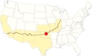
Location of Arcadia on Route 66
Arcadia has hot and humid summers and frequent variations during the other seasons. Winds prevail from the north during winter and the south and southeast during summer. The annual average temperature is 61.4°F (16.3°C). Winters are cool with a mean temperature of around 39.2 °F (4 °C), and the highs and lows range between 48.5°F (9.2°C) and 25.6°F (-3.5°C).
Spring experiences more rain and strong thunderstorms with hail and tornadoes, which may also take place during summer. The summer average temperature is around 83.0 °F (28.3 °C). The average highs and lows are 94°F (34.5°C) and 71°F (21.5°C).
Average rainfall is 36.52 in. (928 mm) annually, with around 84 rainy days per year. Most rain falls during summer. Snow: around 7.7 inches fall every year (19.3 cm), most between December and March.
Tornado risk
Bear in mind that Oklahoma City metro area is one of the most tornado-prone major cities in the whole world: some 150 tornados have hit it since 1890. Some of them were F5 on the Fujita scale, making them the most powerfull tornadoes on record.
Arcadia is located in the "Tornado Alley and experiences approximately 10 Tornado watches annually. Tornado Risk: read more about Tornado Risk along Route66.
Map of Route 66 through Arcadia
Below is a map showing "AutoTrails", roads that cars could use. It was published in 1924, two years before Route 66 was created.
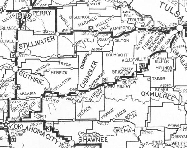
Arcadia is on the lower left side, on a secondary highway. The main road from Luther bypassed it, and also the one from Oklahoma City to Edmond. The highway marked as "50" (in a black square) meaning the "Ozark Trails" would mostly become Route 66. You can follow it from Tulsa to Oklahoma City.

1948 Shell Roadmap central Oklahoma
Click on map to enlarge
Source
See Arcadia in this 1948 roadmap (click thumbnail for full size map). At that time the Interstate system hadn't even been conceived.
Find Arcadia on our Map of Route 66 in Oklahoma, which has the complete alignment of the Mother Road across the state and all the towns along it.
See this map with US 66 alignment in Arcadia 1926 - 1952, and this one showing the bypass east of town built in 1952.
Soldier Creek realignment
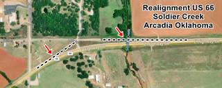
At Soldier Creek (map) the highway was improved and made safer in the 1950s: heading east, after North Anderson St. the original 1926 alignment continued straight with a SW-NE course, met 5th St. and turned sharply eastwards. Then it crossed Soldier Creek and met the current alignment 500 yards further east. This sharp curve was eliminated for a wider one, starting at the Washington Irving Campsite marker, and a new bridge built a few feet south of the old one. The original alignment can be seen in the dead end section of E 5th St. on the western side of the creek. You can spot the change in the tarmac at each end of this realignment.
Route 66 Alignment near Arcadia
With plenty of old maps and all the information of the old roadway.
- Yukon to Clinton (next)
- Chandler to Yukon (Arcadia's)
- Tulsa to Chandler (previous)
Route 66 landmarks & attractions in Arcadia
- City Tour of Arcadia - read on below
- Tours & Itineraries and Parks
Sponsored content
The 1946 book by Jack DeVere Rittenhouse, "A Guide Book to Highway 66" gives us a good idea of the Mother Road during the period that followed WWII. In it, he mentioned its population as 224 and that it had "... one cabin court; cafe; gas; grocery and general store" he added that at one time it was a "fair-sized little town, but its growth has stopped.
Arcadia is a typical rural community located on Route 66 with some intersting historic buildings in the town and with its famous Round Barn and Pops Service Station just west of it. To the east is a historical site: the original 1928-29 paved section of Route 66. Enjoy Arcadia and its sights during your roadtrip.
We will begin our tour on the eastern side of the town, heading westwards, away from Luther. The highway is fairly straight, but at one point (Map) it curves sharply to the north (right) and at that point there is a fork with a narrow paved road to your left.
This narrow road is the Historic Arcadia Section of Route 66, built in 1926. The main highway is the later alignment, built in 1952.
Before you turn left to drive along the historic segment, follow the 1952 alignment for 0.2 miles (map) to visit a quirky Route 66 attraction: "OK County 66 - John's Place". Then return to the original road and drive along it.
OK County 66 - John's Place

Buried Beetle, at John's Place, Source
John Hargrove's Place is located on 13441 E Old Hwy 66, Arcadia. On the 1952 alignment. See this street view of the premises.
John Hargrove created this exhibit of Route 66 memorabilia, vintage artifacts and recreations of classic spots along the Mother Road after he retired.
You can find replicas of Arizona's Twin Arrows, Conway TX's Beetle Farm, the Blue Whale, Jackrabbit Trading Post, a giant Kachina doll (Elk City Ok), and an "Easy Rider" motorcycle.
Reatrace your steps to the fork of Historic Route 66 and follow it, westwards.
Historic Route 66 in Arcadia
Route 66 Jct. N. Hiwassee Rd., Arcadia, OK.
Listed in the National Register of Historic Places
This is an original segment of Route 66 built in 1926, paved in 1928 and 29, and part of the Mother Road until 1952, when it was bypased. There are two markers, one at each tip of the segment (pictured below).
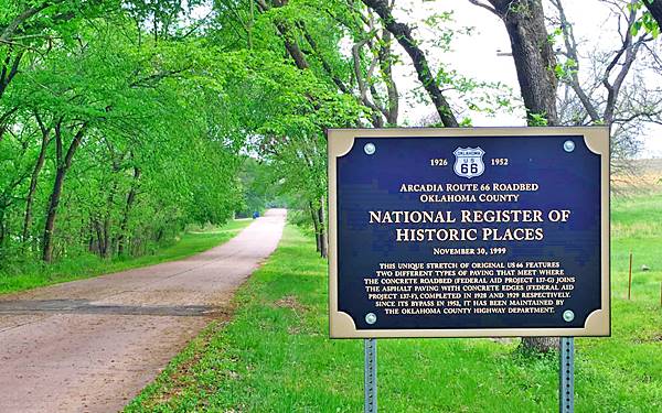
See this Map of the alignment.
It is an "S" shaped segment of road only 0.9 miles long (1.450 m), but it has a long history.
In the days before Route 66 was created, the only highway "network" in the area was the "Ozark Trails" system. It began as a private organization that promoted better roads and prompted counties, towns and states to help build them.
By 1915-1918, the Ozark Trail roads had linked Oklahoma City to the northeastern part of the state (Miami) with a reliable dirt surfaced roadway.
Oklahoma state then improved on this primitive highway and converted it into Oklahoma State Highway Number 7. With federal support some sections of OK-7 were paved in the early 1920s (such as the Nine foot wide Ribbon Road between Afton and Miami.)
Historic section of Route 66 in Arcadia, where the paving types meet
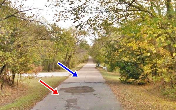
In 1922 the road entering Arcadia from the east became OK Hwy. 7, and in 1922 was still an unpaved road. But four years later, the U.S. government created Route 66 using OK Hwy 7 (from Miami to Oklahoma City), and suddenly this section near Arcadia became part of Route 66.
This part of the road is surrounded by local trees (oaks, cottonwood, cedar among others) and gives a glimpse of what travelers of bygone days experienced when driving along U.S. Highway 66.
It was paved between 1928 and 1929 and preserves to this day the two different paving technologies employed at the time:
- Eastern section: (Blue arrow) is the "first generation paving" (1928) which employed pure Portland Concrete with a Bates Type surface. It was a simple and cheap solution.
- Western section: (Red arrow) more advanced (1929) used a Modified Bates Type design. It had a two-inch thick asphalt surface paved on top of a 5 in. thick concrete base. It also had concrete edgings that were 9 inches wide. This type of paving required an on-site chemist and was more expensive. Similar to the US 66 section in Benld Illinois.
Both types of paving meet in the midpoint of this historic section and the original three-foot high marker of the Federal Aid Project describes both projects.
The road remained in use until the modern upgrade was built to the east, in 1952.
Spot where Paul McCartney asked for directions
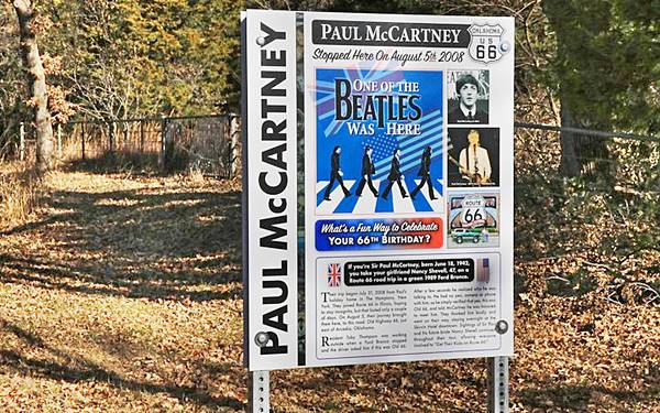
Ahead, to your right (Map) is the "Beatles marker".
It states "One of the Beatles was here", and tells the story of how Paul with his girlfriend Nancy Shevell, stopped on August 5, 2008 and asked local resident Toby Thompson for directions. It was Paul McCartney's 66th birthday (great occasion to roadtrip Route 66!). Thompson told his neighbors Jim Ross and his wife Shellee Graham about this brief encounter.
In 2020 the District 3 Oklahoma County approved the sign, and Shellee designed it.
Phillips 66 gas station styled-house
Head west, ahead, to your right (street view), is a house that was designed to look like a "cottage style" Phillips 66 station from the late 1920s. This is the home of Route 66 historian Jim Ross. There are several of these gas stations along Route 66 (see this Cottage style Phillips 66 in Erick Oklahoma as an example).
Just ahead, after the soft final curve of the "S-shaped" alignment, it meets the 1952 road. Turn left and head west into Arcadia proper. Passing Soldier Creek US66 takes a NE-SW course and just ahead is a "Historic Marker".
Washington Irving Monument
OK-66 and Anderson Road, SW corner (street view). On the left -south- side of the highway.
It marks the spot where Washington Irving (1883-1859), an American writer, essayist, historian, and diplomat saw herds of wild horses running next to the Deep Fork River during an expedition in 1832.
Continue westwards. To your right, on the NW corner of E 1st. ST. and Route 66 once stood a "Gibble Gas Station"
Site of Gibble Gas Station
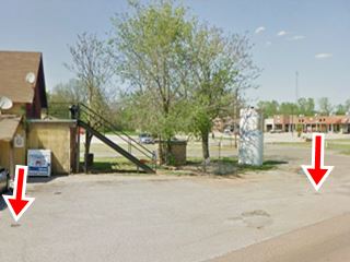
Earl R. Gibble created this gas station company in 1960, it was a classic brand in Oklahoma, now defunct. If you look at the paving, next to the convenience store and the newer gas station to the west of the property, you can see the base of the steel posts that belonged to the old station (red arrow in image below), and maybe the same gabled roof on the left side of both images(?) At that time E 1st St. didn't curve south here as it does now; instead it kept on straight eastwards.

Gibble Gas station in 1979 Source
Across the street, on the south side is a former cafe, diner, and motel, the "Hilbillee's" complex.
Hillbillee's on Route 66

Hillbillee's original structure ca. 1990s
208 E Highway 66. At one time this was a 1930's gas station. Later it became a diner and in the 1980s the old station's pumps were removed. Then, in the early 1990s it became a large complex -that can still be seen behind the "private property" signs.
The complex served as a thematic motel (Hillbillee's Bed amp; Breakfast) owned by Norma Braxton it resembles the Main street of a Wild West cowboy town.
It closed in 2007 and was acquired by the late Aubery McClendon (who made a multi-billion fortune in oil fracking, and that same year opened "Pops" further down the road.
McClendon died in a car accident (aged 56) after he crashed into a bridge , was reportedly on his way to Pops when he crashed his car head-on into a bridge embankment in March 2016.
Below are two pictures of the main building over the years, the red arrows show the open porch facing US66 with many motorcyclists, and the same but closed in, now as a room forming part of the main building.

Motorcyclists and a porch on the building, Source
Historic Tuton Pharmacy
Listed in the National Register of Historic Places
Head west, ahead to your right you can see the large "Round Barn". Turn right along Main St., to park (behind the Barn), and on the NW corner of Main and E 1st St. you will spot the two story sandstone "Tuton Pharmacy".
At 201 N. Main Street. The Tuton Drugstore was built in 1917 and survived the fire which gutted the town in 1924. It is a local sandstone two story structure that houses an Art Gallery.
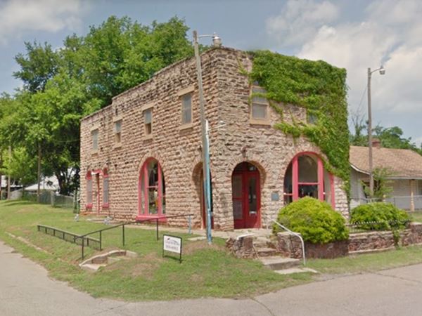
Turn left on E 1st St. halfway down the block, to your left is the Historic Round Barn's parking lot.
Arcadia Round Barn
107 E. Highway 66, Arcadia, OK.
Listed in the National Register of Historic Places
This barn is unique, shaped like a cylinder, with a hemispherical shingled roof. It was built in 1898.
William Harrison "Big Bill" Odor set up his homestead on the Deep Fork River in 1892 and six years later began building his "round barn". He laid down rock foundations and decided to build a circular structure.
Arcadia's Round Barn
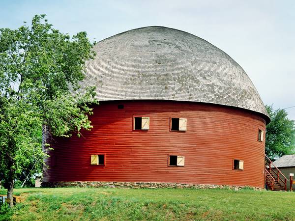
It was therefore designed and built by William H. Odor. He first built a sawmill to cut the local bur oak into timber. The green wood was then fashioned into boards which were soaked in water while green and set in special molds to bend them to the desired shape.
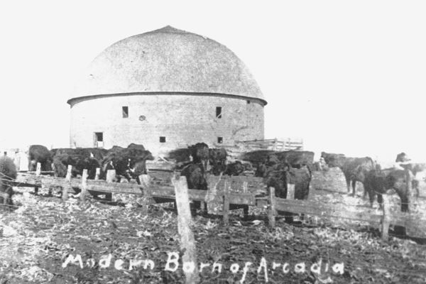
Barn Trivia
In 1903 William Odor and his wife Myra donated part of their land to form the town of Arcadia.
Although he only needed a barn for his hay and livestock, he later laid flooring on the upper story so that it could be used for dances by the local community.
When Route 66 passed by Arcadia in 1926, the barn became one of its most famous landmarks.
Why is it round?
Odor believed that being round would help the structure resist the frequent Oklahoma tornados.
As time passed by, the barn decayed and was only partially standing by the late 1970s when it was listed in the National Register of Historic Places (1977). When the the barn's roof collapsed in 1988, a group of volunteers known as "The Over the Hill Gang" led by Luther "Luke" Robison dedicated work, time and money to rebuild it in four years (1992).
Barn Facts
- It is the only real "round" barn in America (other "round" barns are polygons with six or eight sides).
- It measures 43 feet high and 60 feet diameter ( 13.12 by 18.3 m). It has two stories.
Route 66 Marker
There is a pink stone marker across the street from the Round Barn. Erected in 1994 by the Oklahoma Historical Society (#215). See its Street view. It's text reads:
"Whether motorists called Route 66 the Ozark Trail, Will Rogers Highway, Main Street America, or the Mother Road, all remember Arcadia's Round Barn. The well-known landmark was built in 1898 by W.H. Odor.
The route was designated a national highway in 1926, improvements were made to the 1917 roadbed. The original road between Edmond and Arcadi was constructed by convict labour. The highway through Arcadia was paved in 1929.
Many Arcadia businesses catered to travellers needs with gas stations, cafes, lodging facilities and a grocery and general store."
Just west of the barn is a former Service Station.
Former DX Filling Station
Right beside the round building is the former DX gas station, the gabled building is still standing, but the pumps have gone. The truck is parked next to the now empty concrete gas pumps island under the gabled canopy. The old lighting is still in place, but the neon sign is gone. Compare the then and now sequence below, with the same buildings in the red box. Notice the barn at that time was in disrepair.

DX gas station, Arcadia, Source
The photo below, from the early 1930s or late 1920s shows the same buildings and the old round barn. At that time it seems to have been a Texaco station (see the round sign over the pumps, with a star and the words "Gasoline Motor Oil" encircling it).
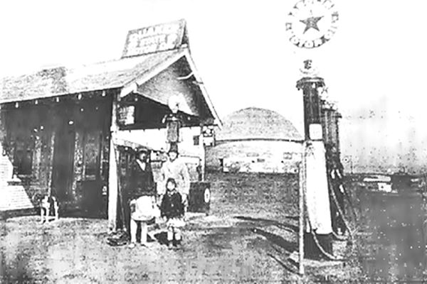
Pops 66 - Soda Ranch

Neon lit Giant Pop Bottle, Source
Head west along Route 66 and after crossing Coffee Creek having driven 0.6 miles you will spot Pops, to your left, on the south side of the road at the junction with N. Westminster Rd.
This is Route 66's most modern and futuristic landmark. It features a collection of over 500 sodas and beverages, 54 types of root beer and +50 cream sodas. So it has food,
soft drinks galore and of course ultra-modern fuel pumps at the service station.
Website: https://www.pops66.com/
Its giant pop bottle is 66 feet tall (20.13 m).
This ends your city tour of Arcadia
Events, Tours & Itineraries
Places to visit

Neon Fest, Arcadia, Source
You can visit the Frontier City Amusement Park, which is 12 miles south along I-35. The Lazy E Arena (10 miles north).
For those interested in history, there is the Historic Downtown Victorian Guthrie (25 miles north).
Natural Attractions & State Parks
Lake Arcadia
1.5 miles southwest of Arcadia, along Route 66. A place for camping, picnicking and water sports: swimming, oating and fishing. There are trails for hiking.
Campsites and RV hookups available. More details at the Lake Arcadia website.
Arcadia 2021 Neon Fest
The 2021 Arcadia Route 66 Neonfest will take place at 13100 E Old Hwy 66, Arcadia. This is a three-day event for Route 66 and neon sign display enthusiasts.
Some sponsored content
>> Book your Hotel in Tulsa

Credits
Banner image: Hackberry General Store, Hackberry, Arizona by Perla Eichenblat
Jack DeVere Rittenhouse, (1946). A Guide Book to Highway 66
Town of Arcadia website www.townofarcadia.com
Dianna Everett Arcadia, Encyclopedia of Oklahoma History and Culture, www.okhistory.org


