"A Place to Grow"
Index to this page

TheRoute-66.com is reader-supported. When you buy through links on our site, we may earn an affiliate commission at no additional cost to you.
About Edmond, Oklahoma
Facts, Trivia and useful information
Elevation: 1,204 ft. (367 m). Population: 81,405 (2010).
Time zone: Central (CST): UTC minus 6 hours. Summer (DST) CDT (UTC-5).
Edmond is just 10 miles north of Oklahoma City, in the north central part of Oklahoma County; it is a part of the Oklahoma City Metropolitan Area. Its Motto is: "A Great Place To Grow".
The area around Edmond has been inhabited for over ten thousand years, as proven by the nearby site at Luther, which dates back to 9,000 BP. The current Native Americans in Oklahoma were relocated there from their original territories in the eastern USA by the American government. The policy at the time was to resettle the natives west of the Mississippi River in the "Indian Territory". Later, in tle late 1880s, pressure to settle the area with European settlers led to a change in policy: the Oklahoma Territory was carved out of the Indian Territory (1890), and surplus land was acquired from the tribes to "open" it for settlement.
The land was settled by means of "Land Runs", where the future homesteaders rushed in to stake out and occupy their lot on a given day and time. It was a race to grab the land and it worked admiraly well.
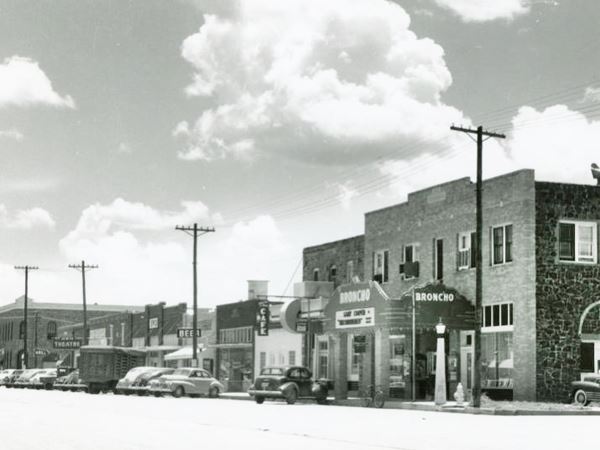
West side of Broadway, looking south, 1947
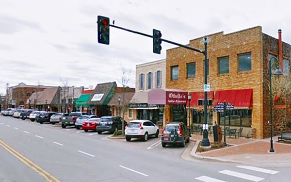
Same place, West side of Broadway, looking south, nowadays
In the meantime, in 1884, the Southern Kansas Railway Co. was granted permission to build a line from Arkansas City KS into Oklahoma, to Texas, with a North to South course. A team of surveyors along the route stopped at "Mile Marker 103" in 1886 and noted its "good spring", which was a crucial source of water for the steam engines. By late 1886 a station was built there and a water well was dug. The railway officials named the place Edmond on March 28, 1887, and four months later the government approved it.
But the railroad would have to wait until the "Oklahoma Land Run" of 1889 to have a town to serve.
The name, Edmond
Edmond Schuyler Burdick (1858 - 1909) began working for the Southern Kansas Railway as an Attorney in 1884. He continued in the Atchison, Topeka & Santa Fe, as an Agent between 1885 and 1895. The Railway named the town after him.
The town appeared in one single event, the "Run" on April 22, 1889, and the settlers chose the land near the station. The tracks (now BNSF) still pass through the town.
Many streets were named after Railway Men or those of the Seminole Town and Development Co., who platted it. One year later its population was 394.
The territorial legislature created the "normal" school in Edmond in 1890, which later became the University of Central Oklahoma. Its first building, the "Old North Tower" opened in 1893 and is a historical site. The University is one of the towns largest employers.
In 1911, the interurban railroad linked it to the state capital.
Trivia: Edmond's Firsts
- The first church (St. John the Baptist Catholic Church, dedicated June 24, 1889) in Oklahoma Territory. It stood on the corner of E1st and S. Boulevard. The congregation still exists, but in another location.
- The First School in Oklahoma Territory, Aug. 1889
- he Edmond Sun which opened on July 18, 1889, is the state's oldest continuous newspaper dating from Oklahoma Territorial days
Farming was the original economic base of the community and when Route 66 was aligned through the town in 1926. It brought a growing flow of travelers and prosperity until realigned in 1954 after the completion of two modern expressways on the northeastern part of Oklahoma City. Oil was discovered in the 1930s and 40s (West Edmond Field), and during the 1950s and 60s the town began to grow as a suburb of neighboring Oklahoma City.

Getting to Edmond
Heading east from Edmond down Route 66 are the towns of: Arcadia (9 mi.), Luther (17 mi), Wellston (25 mi.), Warwick (29 mi.) and Chandler (37 mi.) To the west, are Oklahoma City (11 mi.), Yukon (26 mi.) and El Reno (40 mi.)
Hotels in Edmond
Book your lodging in town, there are plenty of accommodation options.
>> Book your Hotel in Edmond
Lodging Near Edmond along Route 66
There are several hotels in the area close to this town. Alternatively you can also find your accommodation along Route 66 in the neighboring towns and cities. We list them below (listed from east to west):
On Route 66's Main alignment
Eastwards
Westwards
>> There are many RV campgrounds in Edmond.
Edmond’s Weather
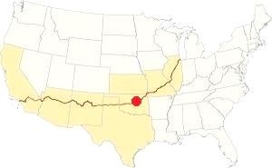
Location of Edmond on Route 66
Summers in the central part of Oklahoma are hot and humid. Winters are relatively mild (but snowstorms can happen) and the other seasons are subject to frequent variations. North winds prevail in winter and during summer those from the south and southeast.
The average yearly temperature is about 61.5°F (16.4°C). During winter the mean temperature is 39.2 °F (4 °C), with highs and lows between 48.5°F (9.2°C) and 25.6°F (-3.5°C).
Snow: around 7.9 inches fall every year (20.1 cm), mostly between December and March. During summer the average temperature is 83.0 °F (28.3 °C) with average highs and lows of 94°F (34.5°C) and 71°F (21.5°C).
The average yearly rainfall is around 36.5 in. (928 mm). And Edmond has some 84 rainy days per year. Most rain falls during summer. Storms (thunderstorms) are common in spring and also summer; some may come with hail and strong winds, and also tornadoes. Tornadoes can hit at any time.
Tornado risk
Edmond is next to Oklahoma City, whose metro area is one of the most tornado-prone ones in the whole world: about 150 tornados have struk this area since 1890. Some of them were very strong (F5 on the Fujita scale, which is the maximum value). Edmond is located in the "Tornado Alley and experiences approximately 10 Tornado watches every year.
Tornado Risk: read more about Tornado Risk along Route66
Map of Route 66 in Edmond

1948 Shell Roadmap central Oklahoma
Click on map to enlarge
Credits
From 1926 to 1954 Route 66 followed what is now State highway OK-66 and 2nd St. into Edmond, then went south along Broadway towards Oklahoma City, this is the map of 1926-54 of Route 66 through Edmond. It had some sections paved with brick, but these were removed in the 1950s. In August 1954 both highways US 66 and US 77 were moved from their alignment along 2nd and Broadway and 2nd Street, to the new I-35 (known in those days as "Sooner Road"), see this Map with 1954 US66 alignment.
The thumbnail map (click thumbnail for full size map) shows Route 66 in a 1948 roadmap. Edmond is above Oklahoma City
Route 66 Alignment near Edmond
With maps and full information of the old roadway.
- Yukon to Clinton (next)
- Chandler to Yukon (Edmond's)
- Tulsa to Chandler (previous)
Route 66 landmarks & attractions
Sights in Edmond
- Edmond City Tour - read on below
- Tours & Itineraries
- State Parks and Outdoors
Edmond Attractions
In his "Guidebook to US Highway 66", published in 1946 after he drove along Route 66 from Chicago to Los Angeles, Jack Rittenhouse described Edmond.
EDMOND (Pop. 4,202; alt. 1191'; Martin's court; Royce cafe is good; Chet Moore garage; stores)... US66 makes a sharp turn in the center of Edmond and runs straight ahead into the business district of Oklahoma City Rittenhouse (1946)
We will start our road trip and city tour on the eastern side of Edmond, coming from Arcadia.
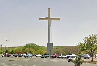
As you reach the overpass at I-35, look to your left to see a gigantic cross next to the freeway.
Giant Cross
On the SE corner of the intersection of Route 66 with I-35, at the LifeChurch campus in Edmond. The cross is made of concrete, and measures 138.5 feet tall (42.2 m). It was erected in 1998. At one time, before the freeway was built, this was an important corssroads with several gas stations.
Head west and as you reach Edmond, to your left is "Fink Park".
Fink Park
Named after Gottlob H. Fink (1867-1930), who settled in Edmond in 1900 and as City Councilman and mayor helped improve the city. The park was dedicated in 1932 and covers 7 acres.
To your right is the large, 19-foot-tall bronze statue of Chief Touch the Clouds, facing Route 66, (street view.
First Public Schoolhouse

Old picture historic Shcoolhouse, Edmond, credits
Listed in the National Register of Historic Places
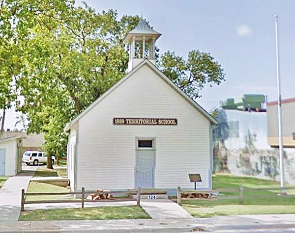
Drive west into town, to your left, after crossing S. Blvd (124 E 2nd St., Edmond, OK) you will spot the small building that housed the first public shoolhouse in the Oklahoma Territory, it opened in August 1889.
It was the last surviving 1889 original structure in Edmond. and the earliest one-room schoolhouse in the State. The School open the first two Saturdays of the month from March to November. 1 PM - 4 PM. Admission is free.
The first public schoolhouse (Aug. 1889) in Oklahoma Territory
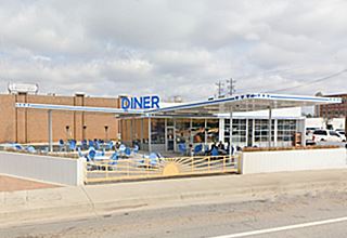
Continue west for one block, to your right, is a vintage Conoco repurposed as a diner.
Sunnyside Diner former Conoco
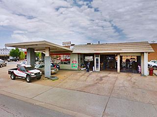
The old Conoco station (marked with red arrows, sign and building, behind the DX station on the facing corner) at 7 E 2nd St, on the NE corner of Route 66 and Broadway, survives as a Diner.

Detail of 1950s photo Conoco Route 66, credits
It had two canopies, one facing each street, a three-bay garage on the eastern side of the property, above is a view of it from E 2nd St., before it was reformed.
It had solid brick pillars encasing thick steel tubes holding up the flat canopies, and mansard shingle roof.
On the SE corner was a DX station, that was torn down long ago.
Across Broadway, on the NW corner was a Dodge and Plymouth dealership.
Route 66 turns left, 90° and heads south along Broadway. Before you turn left, take a right on Broadway to visit the historic bank.
Citizens' State Bank
Listed in the National Register of Historic Places
102 S Broadway and 1st, SE corner. The building is a typical example of a sandstone construction in the Oklahoma Territory in 1901. It had a "burglary proof and fireproof" vault.
Turn around and head south along Broadway, following Route 66 towards Oklahoma City.
Former Phillips 66
To your left on the next corner (Broadway and 3rd St.) is a former rock frame style Phillips 66 station that has been deeply modified.
It retains the original slanted plate glass windows of the former office to the right, with the original white "rock" stone work, plus the "stepped" roof (former service bays to the left are higher than the office, though the metal sheet faux-roofing tries to conceal it, you can see it from the eastern side of the building.
Icebox station
Diagonally across Route 66, on the SW corner of Broadway and W 3rd St.) is an oblong box station with the canopy removed (see its view some years ago, with the canopy). It has two service bays, pump island, and nice brickwork.
Art Moderne Station
There is another old gas station on the end of the same block, on the NW corner of Broadway and W 4th St. It has a single service bay to the right, horizontal brickwork on all walls except the rounded corners of the building and both sides of the service bay, which have vertical brickwork.
A flat canopy on slender steel poles covers the single pump island. There are two offices, each with a door and a window facing the street.
Route 66 former gas station, notice the curved corners & brickwork
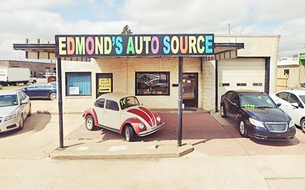
Royce Cafe
Across Broadway, on the SE corner with E 4th St. stands the old Royce Cafe.

Royce cafe 1950s, Edmond, credits
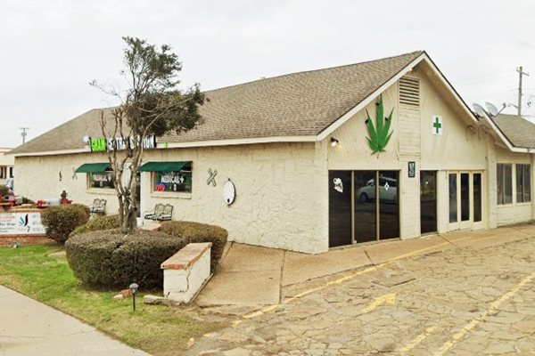
Royce and Neva Adamson opened the cafe in 1933. The long, single floor, gable roofed building was made of the local red stone (now it has been painted white).
It offered "T Bone Steaks, Fried Chicken, Hot Biscuits, Home Baked pies - all food supervised by women."
Royce passed away in 1942 and Neva kept on running the cafe until 1957, when she sold it to Jim Mills. The place closed for good in 1970. It was renown for its Blue Cheese Dressing.
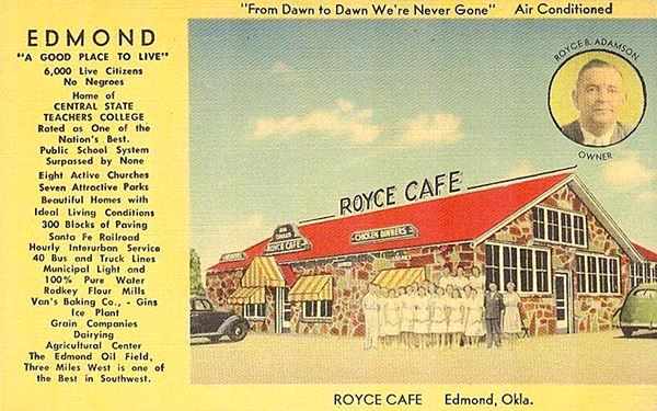
Edmond a "Sundown Town"
The postcard below with Royce B. Adamson's effigy on it, reads "From Dawn to Dawn We're Never Gone" Air Conditioned and on the left side, it mentions the benefits, features and riches of the town, including a comment that is both jarring and terribly racist: "EDMOND 'A Good Place To Live' 6,000 Live Citizens No Negroes"
The fact is that Edmond was a "sundown town", one where "colored people" had to leave the town by sundown, Edmond wasn't alone in its discrimination: over 10,000 American towns were sundowners by the mid 1960s. And 150 of them were located on Route 66.
Black drivers were reminded about this when they filled their tanks at Threatt gas station in Luther, ran by an African American family. They were told that Edmond was a sundown town.
Edmond's original Black settlers slowly moved away after it passed an ordinance banning additional Black residents. Further reading: Was Edmond a Sundown Town?.
Royce cafe postcard with racist text
Royce cafe building nowadays
Happy Blue Hippo

Happy Blue Hippo, Edmond, credits. Click for St. view
Official Edmond Landmark
Head south, to your right at 1129 S Broadway is The Blue Hippo or "Buddy" a fiberglass kitsch art statue that is famous.
It was repainted in 2020 and officially declared a landmark. At one time the local teens would move him about the town as a mischievous prank. Since around 2007 he's been sitting here.
Former town official Bud Fischer kept the Blue Hippo on Broadway, and named it "Happy Hippo". According to Fischer, it was part of an aquatic center that went bankrupt and stream of water would shoot out from the hole of the box-like gadget in the hippo's hands.
Fischer bought it when he acquired a construction company in 1991, it was in two pieces, which he fixed, and put it in front of his shop (Glass Solutions) on Broadway.
Next to the hippo are two motels, the "Red Carpet" and the"Broadway Suites" they don't appear in the aerial photograph of 1964, so they must have been built after that date. They do show up in the 1969 air photograph.
Your City tour of Route 66 in Edmond ends here, continue south along Route 66 to visit Oklahoma City, and consider driving along the Beltline Route 66 too!.
Tours & Events
Events and Fun in Edmond
Liberty Fest
This is a week-long celebration during Fourth of July which takes place every year and attracts 125,000 visitors. It has been chosen as one of the top 10 places to be in America on July 4th by CNN and USA Today.
The event includes: the largest parade in the state, car show, concert in the park, kite fest, fireworks, Scholarship Pageant, Road Rally and a Rodeo.
More details at the website www.libertyfest.org
Farmers' Market
The market is located in the downtown Festival Market Place and you can buy locally grown produce during summer.
Natural Attractions
National & State Parks
Lake Arcadia
To the southeast of Edmond, along Route 66 heading towards Arcadia.
An ideal place for camping, picnicking and enjoying the lake; swimming, oating and fishing. There are trails for hiking and an eagle watch in January.
Campsites and RV hookups are available. More details at the Lake Edmond website.
Cross Timbers
The ecological region where Edmond is located is known as "The Cross Timbers", it is a woodland that is a vast "natural hedge" beyond which lie the open prairies. The forest was between 5 and 35 miles wide and was a formidable obstacle for the first explorers: the closely knit trees with tough wood blocked the carts and horse riders. American author Washington Irving used the expression "Cross Timbers" to define them when he explored the area with the Ellsworth expedition in 1832. The typical trees are blackjack and post oak.
Eagle Watch
For nature lovers, the Arcadia Lake Eagle Watch (January), during which you can spot the bald eagles at the lake. Bring warm clothes and binoculars. At the park office there is plenty of information and helpful staff to get you on track for viewing the eagles.
Some sponsored content
>> Book your Hotel in Tulsa

Credits
Banner image: Hackberry General Store, Hackberry, Arizona by Perla Eichenblat
Jack DeVere Rittenhouse, (1946). A Guide Book to Highway 66.


