Your Route 66 Road Trip through Devil's Elbow
Index to this page
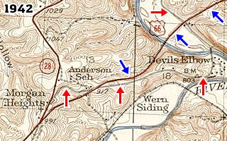
USGS Map from 1942 showing Devil's Elbow MO and Route 66.
Red arrows mark the 1926-43 alignment of US 66. Blue ones the later roadway.
- About Devil's Elbow
- Weather
- Hotels close to Devil's Elbow
- Map of US 66
- What to see and do in Devil's Elbow
About Devil’s Elbow Missouri
Facts, Trivia and useful information
Elevation: 747 ft (228 m). Population n⁄a (2010).
Time zone: Central (CST): UTC minus 6 hours. Summer (DST) CDT (UTC-5).
Devil’s Elbow is an unincorporated community located on the 1926-1943 alignment of Route 66 in Pulaski County Missouri.
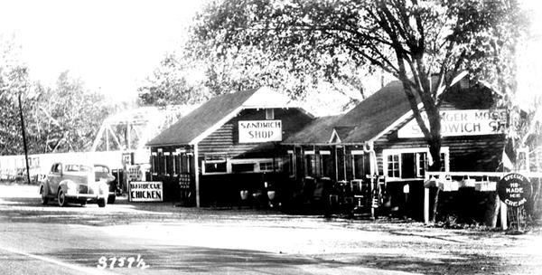
Below is a photo looking west, the old bridge can be seen behind the café
1930s photo of the Munger Moss Cafe in Devil’s Elbow, Missouri
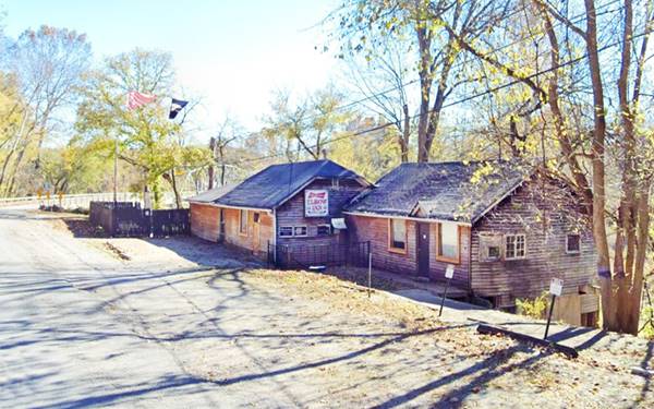
Elbow Inn (2021), looking west. Former Munger Moss Cafe in Devil’s Elbow, Missouri
History of Devil’s Elbow
For the general history of the area check the History of Waynesville.
The first settlement was after the Civil War around 1870 as a small lumberjack settlement. The railroad bypassed it so it was relatively isolated. The village grew in the late 1910s, once State Highway 14 was built and improved in the area, linking St. Louis with Springfield. The construction of the old Bridge in 1923 promoted travel and tourism -because before that, the river had to be forded, which was complicated.
The name: Devil’s Elbow
The Ozark lumberjacks sent their logs downstream on the Big Piney River but the sharp "U" shaped bend jammed the logs leading them to call that point "A devil of an elbow", the name became "Devil's Elbow".
In 1926 Route 66 was aligned along MO-14 and paved. The town grew and catered to the tourists both in-state and those travelling along US 66. A dam had been planned in the 1930s at Arlington which would have flooded the village , but it was never built. In 1940, when Fort Leonard Wood was created, traffic increased considerably and a new safer road became necessary, so Route 66 was widened to a four-lane divided highway between Hooker and Grandview, bypassing the town in 1943.

Where to Lodge near Devil's Elbow
Find accommodation and hotels close to Devil's Elbow in neighboring St. Robert; it has plenty of hotels and motels.
> > Book your hotel in Saint Robert
Your Hotel close to Devil's Elbow along Route 66
There are several hotels in the area close to this town. Alternatively you can also find your accommodation along Route 66 in the neighboring towns and cities in Missouri. We list them below (from east to west):
On Route 66's Main alignment in MO
Eastwards
Westwards
- Hotels in Kansas
- Baxter Springs KS
- Galena KS
- Riverton KS
- Hotels in Oklahoma
- Miami OK
>> Check out the RV campground in neighboring Waynesville
Weather in Devil’s Elbow

Location of Devil’s Elbow on U.S. Hwy. 66
There are clearly defined seasons in Devil’s Elbow. During summer, the average high (Jul) is 88°F (31.2°C); the average low in 67°F (19.2°C). During winter (Jan) the average high is 42°F (5.6°C) and the average low is below freezing at 20°F (-7°C).
Rainfall averages 44.5 in (1.131 mm) per year and falls regularly each month in roughly the same amount). Snowfall is around 9 in. (23 cm), and falls between Dec. and Mar.
Tornado risk
Devil’s Elbow is located in the "Tornado Alley": Pulaski County experiences around 8 tornado hits each year.
Tornado Risk: read more about Tornado Risk along Route66.
Map of Route 66 in Devil's Elbow, MO
1926 to 1943 alignment
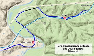
This is the 1926-1943 Google Map from Clementine through Hooker. It is shown in Blue in the map. Then comes a gap in the alignment (black line). Followed by the western segment that goes through Devil’s Elbow shown in Blue (see map).
The 1943 to 1977 alignment
To ease traffic congestion and reduce accidents at World War II Fort Leonard Wood in neighboring St. Robert, Route 66 was improved. It was upgraded to a four-lane alignment and made straighter and safer.

USGS Map from 1942 showing Route 66 in Devil's Elbow.
See thumbnail of a USGS map from 1942. The red arrows mark the original 1926 alignment winding around hills, the blue arrows mark the new wider and straigher 4-lane highway.
This "freeway" became, together with the Pennsylvania Turnpike, the only two highways with four lanes in the U.S. at that time. The new highway opened in 1943 and consisted of a completely new and straight alignment with two lanes separated by a central curbed division.
Hooker and Devil's Elbow were both bypassed by the new road. This new alignment is shown in Pale Blue in the map further up, and also in this 1943-1977 Map with directions.
The Route 66 alignment in Devil's Elbow
Visit our pages, with old maps and plenty of information about US 66's alignments.
- Springfield to Joplin (next)
- Rolla to Springfield (in Devil's Elbow)
- Gray Summit to Rolla (previous)
Route 66 Sights in Devil’s Elbow
"A Devil of an Elbow"
A Route 66 Top Attraction and Beauty Spot
In 1941 it was named "one of the Seven Beauty Spots of Missouri" and an old postcard promoted it as the place "Where the Main street of America (U.S. Hwy. 66) winds its way through one of the most scenic areas in the Ozark region".
The village itself is a "Route 66 Roadside Attraction" of the Hampton Hotels Save-A-Landmark program.
Historic context, the classic Route 66 in Devil’s Elbow
We have two historic references about Devil's Elbow from the 1940s. One written by the Work Projects Administration (WPA) in 1941, and the other by Jack DeVere Rittenhouse in his "A Guide Book to Highway 66", from 1946.
Devil's Elbow (15 pop) is a group of tourist and weekend cottages on a bend of the Big Piney River. The bluffs have been listed by the State Planning Commission as one of the seven beauty spots of Missouri. Legend says the name, Devil's Elbow, was given to the point by lumberjacks who feared and cursed the log jams that formed inevitably at the bend. A trailer camp is among the accommodations. WPA Guide to the "Show Me" state (1941)
Before the new highway was built, the road went past an odd geological formation known as DEVIL'S ELBOW. If you are interested in seeing this, you can take a fork off US 66 from Hooker Rittenhouse (1946)
1923 Route 66 Bridge in Devil’s Elbow, Missouri
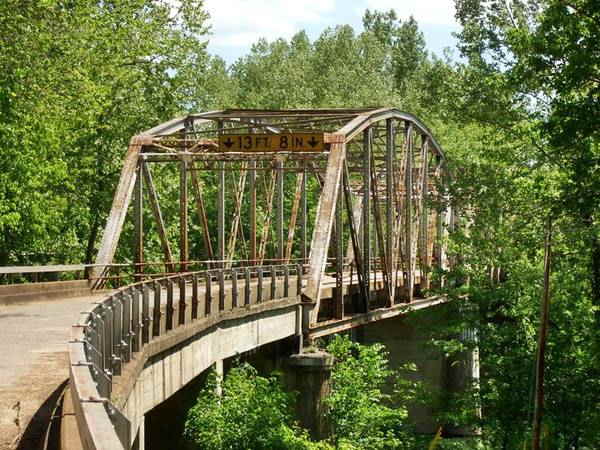
This segment of your Route 66 road trip will start on the eastern side of the village, coming from Hooker and heading towards Morgan Heights. Drive west along the four-lane Route 66 and cross the Big Piney River. Just ahead is the "new" bridge.
Four-lane Route 66
Construction of this highway began in 1942 was one of the country's first freeways. It had concrete curbs that were designed to guide cars and keep them on the road and also to channel rain water. They were dropped in later freeway design as they caused accidents if hit by cars: they tended to roll over.
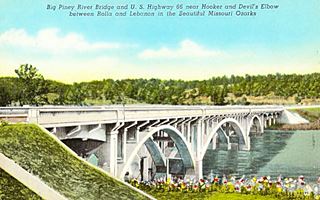
1942 Big Piney River Bridge
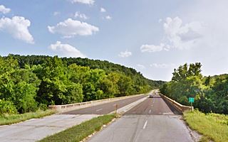
At Hwy. Z and Big Piney River. This concrete bridge carried the four-lane Route 66 over the Big Piney River. It was designed by the Missoury State Highway Commission as an open spandrel bridge, called so because the "spandrel" or space between the arch and the roadbed above it, is open and not solid.
It has three arches and five arched girders. Built by Maxwell Construction Co. Wartime lack of materials led to delays and the highway and bridge opened in late 1945.
Piney Beach Resort
Listed in the National Register of Historic Places

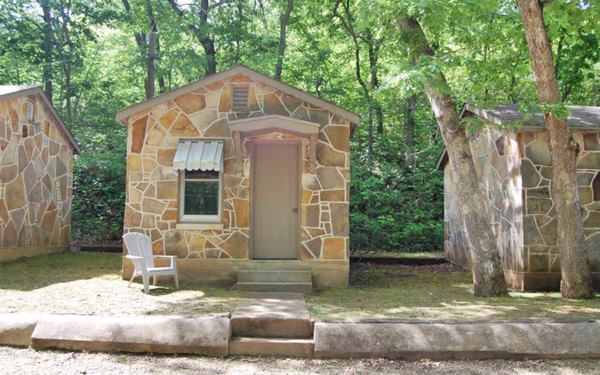
Cabins at Piney Beach Resort on Route 66. Source
Ahead, turn right onto Tranquil Lane and at 12800 Tank Rd. are some 1940s cabins. See map to this point.
Riley Davenport (1919-1980) bought the property from the Browns and built the cabins around 1952. He was abusive towards women and twice married and divorced. He sold the property in 1957 and moved to Waynesville where he ran the Top of the Town nightclub (he was also arrested for assaulting young women).
There were eight cabins, each named after a state through which Route 66 passed, and an office in the middle. All were built in colorful Ozark "giraffe" stonework.
After Davenport the propery was owned by Robert and Merle Murrell (1957-69), Tess Broker (1969-73), the Hartleys until 1975 and then by Wallace Palon until 1982. They remained closed after the flood of '82 until 2006. The 2017 flood also affected business.
Turn around and head back east, to visit Devil's Elbow proper, after crossing the river again, to your right, on the SE corner of Teardrop Rd. and Route 66 is "Dans."
Dale’ Sporting Goods
Also known as Roubidoux Woodworkers it is a simple box-shaped building with a flat roof facing the corner.
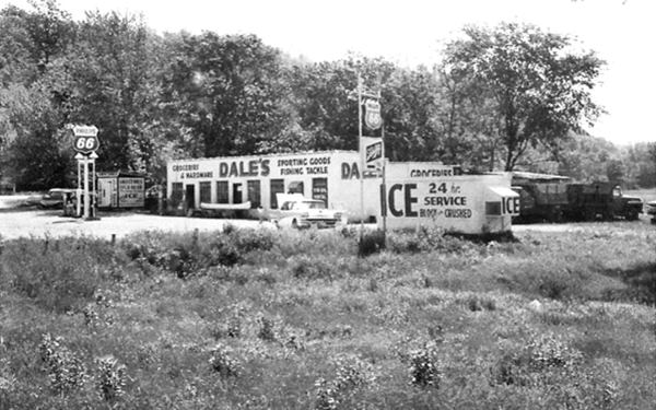
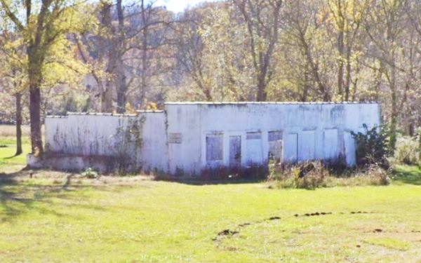
It belonged to Dale Hooker who built it in 1950, it sold sporting goods was a grocery and liquor store, as well as a Phillips 66 gas station. It also sold bait and was a spot where the local fishermen got together. Hooker sold it in 1969 to Verle West who ran it until 1981 when I-44 bypassed the old US66 four-lane highway.
Sunset Rest
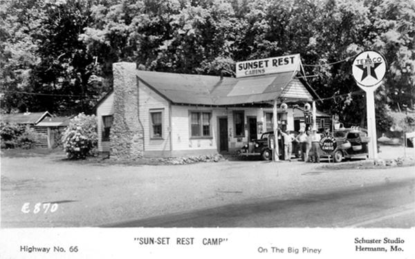
Facing Dale's, on the NE corner of the crossroads is a former Texaco gas station with cabins. The "Then and Now" sequence below shows that the gas station has enclosed the area under the gable roof canopy. The stone chimney on the left is there, but the cabins have gone.
It was also known as "Burgard's"; built in 1933 it is now a private home. It was on the original alignment and it was not touched by the new 1943 four lane highway built along its western flank.
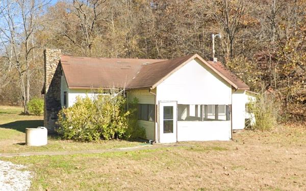
Drive west along Teardrop Rd. towards Devil's Elbow (this is the 1926-43 U.S. Hwy. 66), ahead, after 0.3 mi. to your right, just before the road curves towards the river and the old bridge is "Elbow Inn."
Elbow Inn - Old Munger Moss Sandwich Shop
At 21040 Teardrop Road Devil's Elbow, a long gable roof wooden building nestled between the highway and the river.
Looking east along Route 66, a 1930s postcard
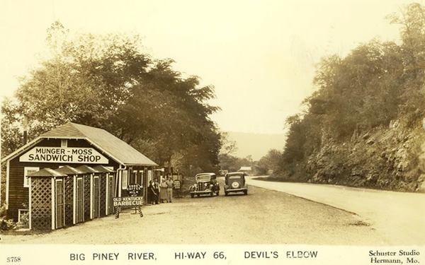
Elbow Inn history
Nellie Draper Munger who operated a resort south of the village with her husband Howard, became a widow in 1930. She later married Emmett A. Moss and both built this
cafe and sandwich shop by the Big Piney River in 1936.
It was famous for its "Old Kentucky barbecue". When the new four-lane highway was completed in 1942 it bypassed their cafe. So they sold it to Jessie and Pete Hudson in 1945 and moved to Lebanon,
where they opened the Munger Moss Motel.
The cafe had a wooden building with a gabled roof that is still there. After 2006 it was the "Elbow Inn & BBQ Pit", frequented by bikers and decorated with the bras of its patrons (see photo above).
It suffered damage during the 2017 flood and in 2019 Susie and Terry Roberson, who had ran it since 2006, were given notice by the property's owners the Thompsons (Paul and Nadean Thompson purchased the inn and 44.9 acres of land back in 1949 for $3,500). It is currently closed and being renovated (since 2019, and the pandemic of 2020-21 has slowed down the work.)

2017 flood at Elbow Inn. Source

Bras decorated Elbow Inn. Source
Just ahead, after a curve that was a dangerous one during the Route 66 golden days, is the "Old Bridge".
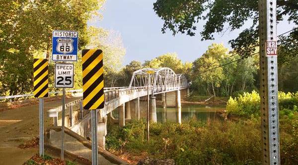
Route 66 Bridge at Devil's Elbow
Teardrop Rd. and Big Piney River, the bridge is 589 ft. long (180 m) and its deck is 19.4 ft. wide. It has two steel spans and is a through truss bridge. It carries the original Route 66 alignment across the Big Piney River at Devil's Elbow.
It was built in 1923 by Riley-Bailey Construction Co. (so it predates Route 66 by three years), it originally formed part of Missouri State Highway 14. It consists of a Warren pony truss, two Parker through trusses and a curved eastern section with four concrete girder spans. After the new bridge was built in 1943 on the four-lane alignment, it was bypassed and only used by local traffic, lack of upkeep condemned it, but it was saved by Route 66 activists and restored in 2013.
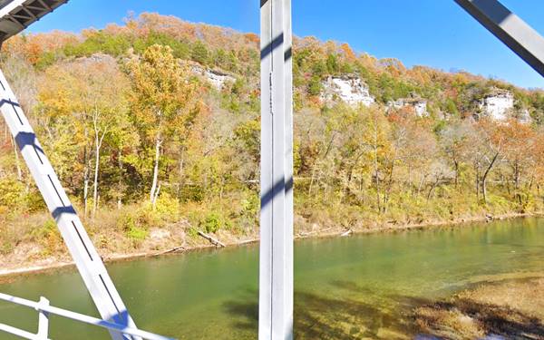
Hiawatha Bluffs
As you cross the bridge look left to see the beautiful white limestone bluffs on the northeastern shore of the Big Piney River, the Devil's Elbow is caused by this sheer cliff. At one time they were promoted as "Hiawatha Bluffs" and they are alos known as the "Sugar Bowls." Pictured below, seen from the bridge.
On the southern side of the river at Teardrop Rd. and Timber Road is the townsite of Devil's Elbow.
The Devil's Elbow Historic District
Listed in the National Register of Historic Places
Devil's Elbow Historic District covers the buildings at the crossroad, one of them was torn down after the terrible flood of 2017.
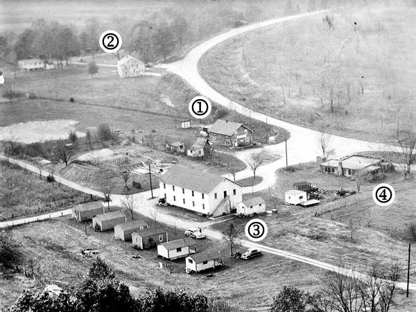
The image below looks west from the bluffs, and shows (1) Hiawatha Lodge, (2) Graham’s Camp and the now gone (3) McCoy’s Store and cabins, and (4) Devil’s Elbow Café. Route 66 curves around the top of the photo.
1940s aerial view of Devil's Elbow
Hiawatha Lodge
12198 Timber Lane on the SE corner at Teardrop Rd. Marked (1) in the image above.
Now a private home, it was built as a hotel in 1917 by Thomas Edward Hunter and his wife Rhoda ("Tilda") Matilda Hunter.
It is a two story building with gabled asphalt-shingled roof. If you look carefully you can see the original log walls on the upper floor, the rest has been covered with plastic siding. The red arrows in the "Then and Now" images below show the log wall and the same two windows!
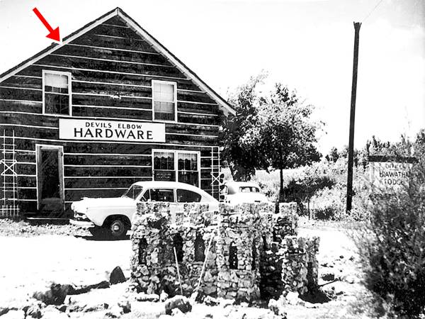
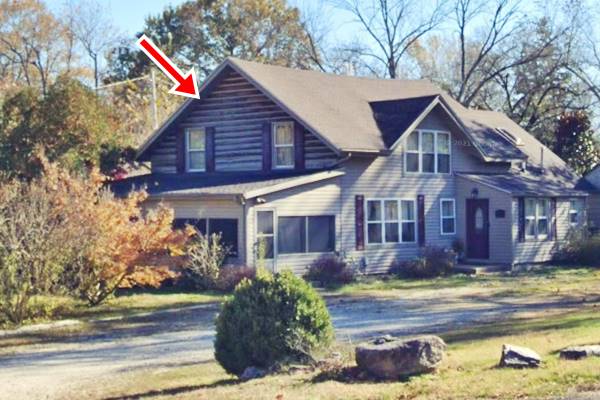
There were more buildings at the main crossroads of Devil's Elbow, that have been torn down, marked (3) and (4) in the image further up, and another building that does not appear in that picture because it was built a few years later.

2017 flood in Devil's Elbow. Source
The image shows the flood of 2017 that rose eight feet above the previous record flood over 100 years ago. The arrows show the buildings mentioned below.
Site of Devil’s Elbow Café
The Conoco gas station and Devil's Elbow Café stood on the NE corner with Route 66, at 21104 Teardrop Rd. opposite Hiawatha Lodge. It is number (4) in the aerial view from 1940.
It was built by Dwight Rench in 1932 and served as thee local post office from 1931 to 41. It burned down in 1970 but the original well pump house built in Ozark "giraffe" stonework survived until the flood razed it in 2017, the pump house is marked with the red arrow in the image above.
The cafe's postcards said it was located "where the main street of America (US Hwy. 66) winds its way through one of the most scenic areas in the Ozark region."

Shelden's (former Miller's Market). Source
Miller’s Market
12175 Timber Lane. To the right of the old cafe site, and marked with a blue arrow in the flood image. It is the old post office. It was known as "Millers Market". Atholl Miller built it in 1954; he was the son-in-law of McCoy -who owned the store and hotel next to it. Miller was postmaster and ran the store until 1982. Now it is "Shelden's Market".
McCoy’s Store - Gone
Marked (3) in the image further up and with the black arrow in the flood picture. It stood at 12177 Timber Lane, on the right side of Miller's Market and was badly damaged by the flood of 2017 and torn down.
It was two-story wood frame building and it was known as McCoys Store and Camp. Charles McCoy (1892-1972) who relocated here during the Depression built it in 1941. He was postmaster and his store and hotel had rooms on the upper floor, a dance hall and seven cabins built in 1948. The cabins have also gone. The place closed in 1954.
The now gone McCoy’s Store in Devil’s Elbow, Missouri
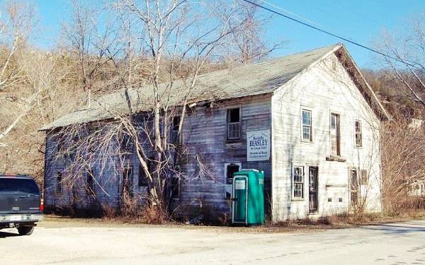
Graham’s Camp - Big Piney Lodge
If you head 0.1 mi. west along Route 66 you can see the remains of a former Camp with cabins, to your left at 21150 Teardrop Rd. The remaining building is marked (2) in the image further up.
It was owned by Walter Edward Graham and his wife Fern. He had been a guide in the Ozarks and in 1927 built 14 cabins on the new Route 66, it was a fishing camp and resort with café and gas. Later it became the "Big Piney Lodge" or "Piney River Lodge". The old camp's office with giraffe-pattern stone walls is still standing.

Devil's Elbow Cut
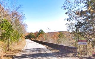
Drive 0.2 miles west, here the highway climbs along the bluff on your right. Explosives blasted the limestone to widen the old trail and a stone wall was built (left) to keep the cars from falling over the cliff into the river below. Notice the original concrete roadbed and the concrete curbs on both sides of the roadway in the walled section.
This was a dangerous sector, as the road runs next to a steep drop towards the river below. It helped give the road its ominous nickname "Bloody 66". The stone wall that is still in place served as a guard rail and was built by the Works Progress Administration (WPA) in 1938.
Scenic Overlook
On the western tip of the masonry wall is a scenic overlook with a great view of the river below with the two steel spans of the 14-mile-long Frisco Railroad spur from Newburg to Fort Leonard Wood. There is an impressive wood tressle bridge carrying the tracks on the western side of the river. It was built in 1941.
To continue your Route 66 Road Trip and visit the next town, head west towards the small community of Grandview, where the 1926-43 Route 66 meets the four-lane U.S. 66. We describe this spot in our Morgan Heights page.

Some sponsored content
> > Book your Hotel in Lebanon

Credits
Banner image: Hackberry General Store, Hackberry, Arizona by Perla Eichenblat
Jack DeVere Rittenhouse, (1946). A Guide Book to Highway 66
Devil's Elbow Historic District National Register of Historic Places form
Piney Beach Resort National Register of Historic Places form
Missouri: The WPA Guide to the "Show Me" State (1941)
Architectural - Historic Survey of Route 66 in Missouri and Detailed Survey, Maura Johnson. 1993


