Route 66 in Pasadena CA
Index to this page
About Pasadena California
Facts, Trivia and useful information
Elevation: 863 ft (263 m). Population 131,977 (2025).
Time zone: Pacific (MST): UTC minus 8 hours. Summer (DST) PDT (UTC-7).
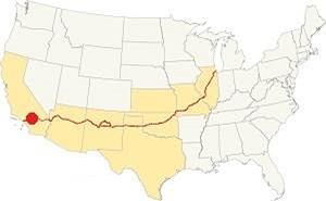
Pasadena is a city located on Route 66 in Los Angeles County, in southern California, on the San Gabriel Mountains' foothills. It is part of the Los Angeles metropolitan area.
The history of Pasadena
Paleoindians settled in the San Gabriel Mountains' foothills around ten thousand years ago at the end of the last Ice Age; and their descent, the "Tongva" natives were encountered by the Spanish when they explored the area in the 1600s. They called them "Gabrieleños" or "Gabrielinos", after the mountains north of their settlements. The Spaniards established The San Gabriel Mission ini 1771 in the valley in the mountain' foothills. It owned a vast tract of land that was nationalized by the Mexican government in the 1830s (Mexico had become independent from Spain in 1821).
The Rancho del Rincon de San Pascual (Saint Paschal's corner Ranch) covered 13,694 acres (5.540 ha) and was granted to Juan Marine in 1834; after his death, José Pérez and Enrique Sepúlveda received the property (1839), and when they passed in 1843, Manuel Garfias claimed it and got the land grant from the Mexican Governor Micheltorena.
Mexico was defeated by the US in the 1846-48 war and had to cede territory to the victor; this included California, which became a state of the US in 1850.
Garfias sold part of his interest to an American, Benjamin Wilson in 1852 (he was the grandfather of WWII General George S. Patton, Jr.) A project to build a large adobe house on the property ended up bankrupting Garfias who sold out to Wilson in 1858.
In 1860 Wilson sold half of his holding in the Rancho to John S. Griffin. And when a group of investors from Indianapolis, Indiana, scouted the area for a more balmy place to live (1873), they bought most of the property from Griffin.
The land which ran between Arroyo Seco River (Spanish for Dry Creek), and what is now Fair Oaks Ave. became the Indiana Colony, after the state of the new owners, and it incorporated in 1874. The land to the east was part of Wilson's Lake Vineyard. Both merged into Pasadena ten years later. Incorporating as a city in 1886.
The Name, Pasadena
The opening of the post office in 1875 required a formal name. And Pasadena was chosen.
Calvin Fletcher, one of the town's stockholders knew that Manuel Garfías had built is house there because it was "the key to the Ranch", its entrance point, T. B. Elliott, president of the Colony then asked a friend of his, a missionary among the Chippewa Indians to translate it into an Indian verison. This led to "Weoauqn Pa sa de na" (Crown of the Valley) which was shortened to "Pasadena".
The Los Angeles and San Gabriel Valley Railroad built a line along the Arroyo Seco and linked Pasadena with Los Angeles; it later became the Santa Fe Railroad in 1887, which had reached the area linking it with the main line, all the way east to Saint Louis.
The Pacific Electric Railway "Red Car" streetcar system also extended a line along the Arroyo Seco into Pasadena.
The town's good weather drew many wealthy people to it, and on the western part of Pasadena are the remains of their 1890's mansions, along Orange Grove Ave., known as Millionaire's Row.
The use of the automobile had grown considerably in the early 1900s, and the National Old Trails (N.O.T.) Association was formed to promote the construction of a highway linking New York with L.A. This highway ran along Colorado St. and Foothill Blvd. eastwards towards San Bernardino, and south, through South Pasadena, into Los Angeles.
US highway 66 (Route 66) was created in 1926 aligned along the N.O.T. highway through Pasadena. It would go through many changes in its alignment over the course of the years which we describe below in our maps section.
The Los Angeles freeway system was born with the Arroyo Seco Parkway in 1940, between L.A. and Pasadena. Route 66 was aligned along it. Soon more freeways and the Interstate highways would cover the region and in 1964 Route 66's western terminus was moved from Santa Monica to Pasadena, in 1974 it was moved further east, to Needles CA.

Accommodation in Pasadena
You can find many lodging options in Pasadena
> > Book your Hotel in Pasadena
More Lodging close to Pasadena along Route 66
Below you will find a list some of the towns along U.S. Hwy 66 east and west of Pasadena; click on any of the links to find your hotel in these towns.
>> Check out the RV campground near Pasadena, in Pomona
The Weather in Pasadena
Location of Pasadena on Route 66
The climate in Pasadena is a "Hot Summer Mediterranean" one. Rather dry and hot in summer but cool and wet during winter (which can bring heavy rains), the January night temperature often falls just below freezing. Spring is warm and Summers are hot, with high temperatures extending into October which brings a short Fall, cool and hot, erratic.
Pasadena has some 290 sunny days each year and during fall (autumn) strong dry winds blow from the desert (Santa Ana winds) drying out the area and increasing the risk of wildfires in the foothills.
The summer average high is 89.4°F (31.9°C) and the average low is 61.1°F (16.2°C). During winter the average high is (Jan) 67.8°F (19.9°C) and the average low is 44.3°F (6.8°C) in winter, the peaks of the San Gabriel Mountains receive snow, and may very rarely fall in Pasadena. You may experience some frost during winter (Dec. to Mar.)
Rainfall averages 21 in. per year (535 mm), most rain falls during the period from November to April, the rest of the year less than 0.5 in. falls monthly. There are 43.8 rainy days yearly.
Tornado risk
Pasadena is so close to the Pacific Ocean and so far from the Rocky Mountains (the western limit for tornadoes) that there is no risk of thems in town.
Tornado Risk: read more about Tornado Risk along Route66.
Map of Route 66 near Pasadena
>> Custom map of Route 66 on the eastern side of Pasadena.
>> Pasadena to Santa Monica custom map
And our two other custom and interactive maps:
National Old Trails Highway (N.O.T.) in Pasadena
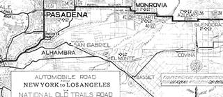
The 1910s N.O.T. highway system was aligned along Foothill Blvd from Pasadena to Monrovia on its transcontinental route between Los Angeles and New York.
1912 N.O.T. Road map
Click on image to enlarge.
Credits
As mentioned further up, by the early 1910s automobiles were becoming popular, but the highways were mostly dirt trails with ruts and potholes that were unsuitable for cars. Across the nation organizations were created to promote better roads. This led to the creation of the National Old Trails (N.O.T.) Association that lobbied for a highway between Los Angeles and New York.
The N.O.T. map (click to enlarge) shows its alignment across this area, it can be seen on Foothill Avenue between Monrovia and Pasadena, and along Fair Oaks Ave and Huntington Dr. south of Pasadena as it heads into Los Angeles.
Route 66 Map
In 1926 Route 66 was aligned along the National Old Trails roadway and the green line marks the 1926-34 alignment of Route 66 along Foothill Ave into Eastern Pasadena.
The following map shows the highway in the Los Angeles region in 1927. You can follow Route 66 from Victorville in the east, to San Bernardino and west to Pasadena and Los Angeles. Pasadena is on the lower left side.

1927 Road map, SW CA
Click on image to enlarge.
Credits
The black and white 1930 thumbnail map above also shows the alignment of Route 66 from Victorville to Los Angeles notice the detail with the alignment into Pasadena and onwards into Los Angeles.
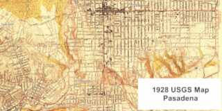
The other map below, was published in 1928; it shows Route 66 running from Duarte, across Monrovia, Arcadia, south of Sierra Madre, and into Eastern Pasadena. It shows it running along Foothill Blvd. and Colorado into Pasadena.
In 1933 Route 66 was realigned along Huntington Dr., Colorado Pl., and Colorado St., and it is marked with a Until then it ran along the course marked with a red line in our custom map.
Route 66 Westwards from Pasadena
There were several alignments of Route 66 from Pasadena into Los Angeles during the period spanning 1926 to 1940. It was only after 1940, when the Arroyo Seco Parkway became the route for US 66 into LA that these changes stopped. Contemporary maps don't clearly mark the course of US 66 into LA, and we have written extensively about it in our Pasadena to Santa Monica alignment webpage.
Our custom maps show some of these alignments, one through South Pasadena, another through Eagle Rock.
Finally there was an Alternate Route 66 alignment from Los Angeles into Pasadena along N Figueroa St. and Colorado Blvd.
Route 66 Alignment near Pasadena
With maps and full information on the Mother Road.
- Pasadena to Santa Monica (Next)
- Barstow to Pasadena (Pasadena's)
- Topock to Barstow (Previous)

Route 66 sights and attractions in Pasadena CA
Historic Context
The 1939 "Guide to the Golden State" written by the WPA gave a complete description of Pasadena, and pointed out the following:
... The center of the small business district is the intersection of Colorado Street and Fair Oak Avenue. Here the streets are lined with smart shops, lighted at night with a restrained display of neon lights... Near the western margin of the city is a remnant of the architectural glory of the 1890's Orange Grove Avenue, known as "Millionaires' Row," a street of mansions in massive style set behind well-manicured lawns... WPA (1946)
Just after the end of World War II, Jack DeVere Rittenhouse drove the whole of Route 66 collecting information for his famous 1946 work, "A Guide Book to Highway 66". He mentioned a list of the towns along Route 66 and dedicates the following to Pasadena : "... Now you pass through SIERRA MADRE at 353 mi. and soon enter PASADENA at 359 mi. Pasadena is famous for its Rose Bowl, Tournament of Roses and the Pasadena Playhouse. From Pasadena, you drive over city streets into LOS ANGELES, where you reach the City Hall."
Pasadena City tour: Stops and Landmarks
Begin your Pasadena leg of your Route 66 Road Trip on the eastern side of town, on Route 66 (E. Colorado Boulevard and Michillinda St., just past the Former Eaton's Hotel in Arcadia), and drive west along E. Colorado Blvd.
Colorado Boulevard
Known as Colorado Street until 1958. This main throughfare runs eastwards from Orange Grove Blvd. by the Arroyo Seco gully in Old Town Pasadena up to Michillinda Avenue where it becomes Colorado St. after entering neighboring Arcadia.
In 1929 it was widened by cutting back the buildings on each side of the road by 14 ft. (4.3 m) on each side of the street.
The avenue was later extended west all the way to Monrovia in the east, and westwards across Eagle Rock (an independent city that was annexed by Los Angeles in 1923) and through Glendale.
We will describe the spots that have been torn down and mark them with a red cross: ❌
On the NW corner of the crossroads at 3897 E Richfield was Jim's Richfield Service Station ❌. Followed by a classic eating spot.
Bennie's Club House ❌
At 3875 E Colorado, it was owned by Bennie Taylor. Its postcard proclaimed "Buffet Dining At Its Best Complete meals for $1.75 'EAT ALL YOU LIKE' Specializing in Prime Ribs of Beef Chicken and Bar-B-Q; " Its 1959 telephone directory entry states "ALL-U-CAN EAT... Cocktail Lounge, Free Parking."

Bennie's Club House. Source
Click image to enlarge
Brown Bear Motel
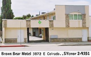
Pictured above, the 1958 telephone directory places it opposite Bernie's, at 3872 E Colorado. The narrow two story building with a rock facade and a portico is still standing; it became an apartment complex.
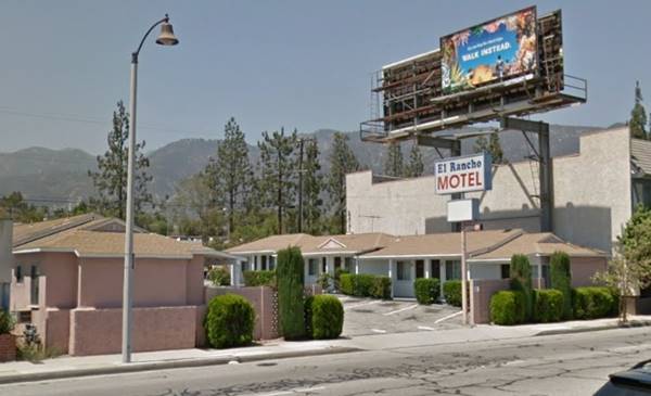
El Rancho Motel
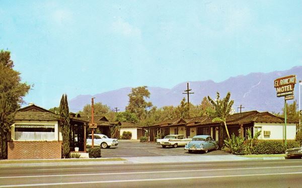
Next to Benny's at 3853 E Colorado, also to your right. It is still operating as a motel on old Route 66 in Eastern Pasdena.
The Pasada Motel
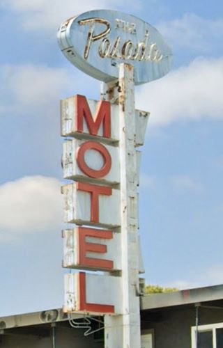
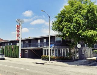
After 0.4 mi. at 3625 E Colorado Blvd. to your right. It is one of the few remaining vintage Route 66 motels in town.
It dates back to 1959 and has a square layout around a central courtyard. Still operating as a motel.
The neon sign is a survivor from those days. By the way, "Pasada" a shortened form of "Pasadena" which, by the way, in Spanish means: "to pass by something."
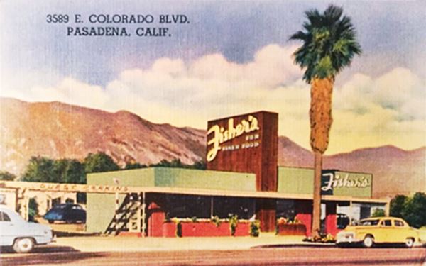
Fisher's
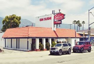
On the next corner (3589 E Colorado) NW with Lotus St. is the building that housed Fisher's "For Fine Food. Dine in an Atmosphere of Refinement." The building is still standing, with its characteristic vertical wall. Now it is a Japanese sushi restaurant.
The 1958 phone directory mentions a second location at 125 Marengo. This one opened in 1947 and Clarence Fisher owned it. He had come to Pasadena from Milwaukee in the 1930s and had worked at Van de Kamp Holland Dutch Bakeries prior to opening The Headliner chain of restaurants (one of them at 3550 E Foothill, the older Route 66 1926-32 alignment here in Pasadena), then he opened Fisher's.
Monterey Lodge Auto Court ❌
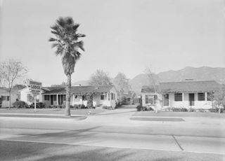
Monterey Lodge Auto Court. 1940s. Pasadena. Source
Click image to enlarge
At 3491 E Colorado. The sign in their 1940's photograph informs about "Steam heat", "United Motor Courts", and "AAA". Now there is an automobile dealership on the corner property.
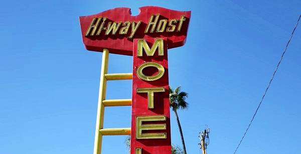
Hiway Host Motel
Opposite, down the block, at 3474 E Colorado Blvd. is this classic motel. It's eye-catching neon sign is worth stopping for a photo.
Its 1959 telephone directory entry reads: "NEW 1957 - REASONABLE RATES 40 Air Cond. Units - 17 Kit. Apts. AAA - Pool - Ffree TV & Phones in Rooms."
The Route 66 sign of the Hiway Host Motel
Bella Vista Motor Court ❌
At 3448 E Colorado, the Bella Vista ("Lovely View" in Spanish) was owned by F.W. Karbiner and H. W. Wertens. It had "Twenty modern apartments and cottages." It was razed in the early 1960s when Thorson's Buick dealership's building was built.
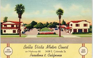
Bella Vista Motor Court. 1940s. Pasadena. Source
Click image to enlarge

Gypsy Trail Motel. 1940s. Pasadena. Source
Click image to enlarge
Gypsy Trail ❌
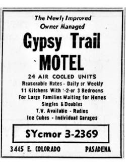
Gypsy Trail, 1959 phone directory ad. Source
Pictured above, it was across from the Bella Vista, to your right, at 3447-45 was the Gypsy Trail Motel.
Operated by Mr. & Mrs. K. H. Mac Kenzie. Part of United Motor Courts "25 minutes from the Heart of Los Angeles." Torn down by the late 1960s.
Grand Motel ❌
Recommended by Duncan Hines the Grand Motel was "a truly modern-beautifully equipped Auto Court. Inviting - friendly - comfortable."
Located at 3321 E Colorado, the old bungalows were torn down in the mid-1980s when a completely new motel building replaced it, the "La Rêve" hotel now stands on the property.
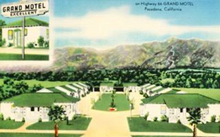
Grand motel. 1940s. Pasadena. Source
Click image to enlarge
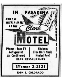
Clark Motel, 1959 phone directory ad. Source
Clark Motel ❌
Crossing Kinneloa Ave, to your right at 3019 E Colorado was the Clark Motel. Located by Eaton Wash, a windows, furniture. and lumber store stands on the property. According to the postcard below, it had "22 modern cottages, 16 with Kitchens, Mr. and Mrs. C. A. Gibson, Owners and Operators." Over the years it added "Heated Pool... Phones T.V. Radios" and was owned by Mr. & Mrs. F. H. Redewill, Mr. & Mrs. Fred Brandenburg. Razed in the mid 1970s. See it in this aerial view.
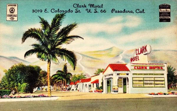
The Pasadena Business Guide for 1939 mentions Oak Park Camp owned by Mrs. Mildred at 3020 E Colorado. Its matchcover tells us it was located on the "East City Limits." It was opposite Clark's, on the eastern side of Eaton Wash. By the early 1970s it had gone.

Tropics Motel, 1959 phone directory ad. Source
Tropics Motel ❌
The Motel Tropics is listed in the 1959 phone book at 2954 E Colorado, SE corner with El Nido Ave. with "Rooms Planned for your comfort. Cooled by Refrigeration-Sound Proof. Opposite Gwinn's Restaurant."
El Nido Motel
The local 1959 phone directory lists an advertisement of "El Nido Motel Apts. Delux Apts. - Kitchen Facilities By the Day - Week - or - Month 1⁄2 Blk. So. of Colorado 27 El Nido." And the building is still standing (st. view).
Gwinn's Restaurant and Drive-In ❌
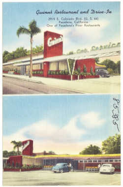
Gwinn's, 1940s. Pasadena. Source
Click image to enlarge
The now gone restaurant and drive-in stood at 2915 E Colorado. Floyd O. Gwinn (1897-1972), former mayor of Pasadena (1964-66), owned it. He moved to California in 1926 from Indiana, and settled in Pasadena in 1939. He worked in the restaurant business for more than 40 years.
The building was designed by Harold J. Bissner and Harold B. Zook with a modern design in 1948. Torn down in the early 1990s.
Ace-Hi Motel
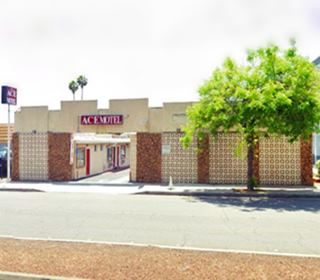
On the next block at 2870 E Colorado St. is this classic motel. Its 1956 postcard described it as follows: "large comfortable units with full-tile showers. Close in. Lee B. Balaam, Owner, Mrs. H. Johnson Mgr."
The facade has changed a bit but the layout is untouched, with a main entrance portico, now with crenels along the top and designer hollow brick panels.
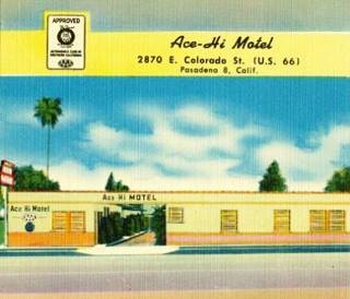
Vintage postcard, Hi-Ace Motel in Pasadena. Source
Across from the Ace, at 2849 E Colorado was "Mee Jin Inn Chinese Food, Genuine Chop Suey - Chow Mein, owned by George Y. Pon... In Pasadena since 1934."❌
Across the street, to your left there are two classic Route 66 motels with special design features: The Astro and the La Casa Inn:
The Astro Pasadena Motel

The Astro motel 1960s, Pasadena. Source.
Click image to enlarge
Here, according to the 1959 telephone directory, on the SW corner at 2830 E Colorado stood the Schick's Union Station; it was torn down in the late 1980s to make space for the Astro Motel's parking area.
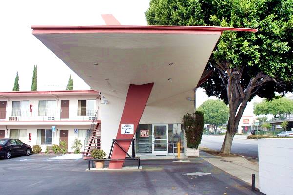
Next to it at 2818 E Colorado Blvd. is the Astro motel with its typical "Googie" (pronounced "gu:gi") architecture style that was very popular in the 1960s during the Atomic and Space ages. These buildings featured futuristic geometric shapes with symbolic motion designs and aerodynamic themes like this motel's wing-shaped canopy.
Still open and operating as a motel.
Astro Motels and Route 66
Learn all about these Space Age motels along U.S. 66.
> > Read more: Visit our Astro Motels on Route 66 webpage.
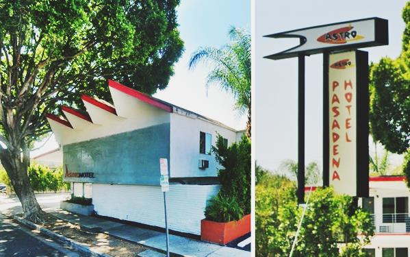
The sawtooth roof was a feature of the Astro motels, and the flag-shaped neon sign too. The Astro motel chain opened in 1964 as the and spanned California, Utah, Arizona and even reached Kansas.
The "Space Age" design of the former Astro Motel's canopy
Hyatt Chalet - Lodge
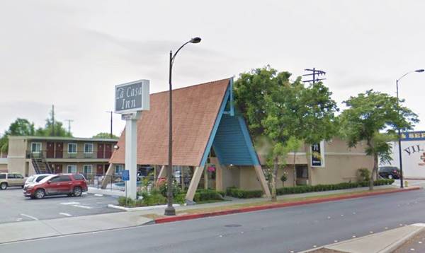
Next to the Astro at 2800 E Colorado Blvd. At one time it was a Hyatt Chalet. This design dates back to 1960 when Hyatt planned to build some 200 similar motels by 1966. They became the Hyatt Lodges, a new division within the company. This one has very "sixtyish" colored glass panes on the facade. Notice the steep gabled roof.
Compare it to some of the extant motels of this chain, also on Route 66: the Needles Inn (Needles CA) and the Hyatt Chalet Motel in Albuquerque New Mexico.
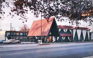
Hyatt Chalet, early 1960s Pasadena. Source
Click image to enlarge
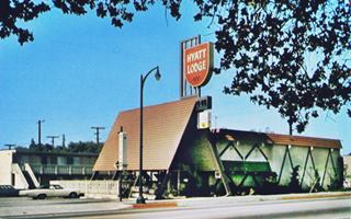
Hyatt Lodge, late 1960s Pasadena. Source
Click image to enlarge
The old Hyatt Chalet nowadays
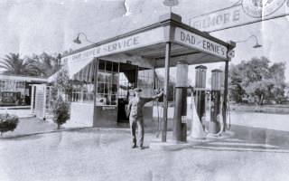
Dad's and Ernie's station, 1930. Pasadena. Source
Click image to enlarge
Many years before the chalet was built, Adolph Thore and Ernie Pare (the garage's mechanic) owned and ran Dad's and Ernie's Gas Station ❌, here on the SE corner of Daisy Ave. at 2830 E Colorado. They sold Gilmore branded gasoline. The image is from 1930. Click on it to enlarge it, Adolph Thore is standing by the pumps.
Travelodge ❌
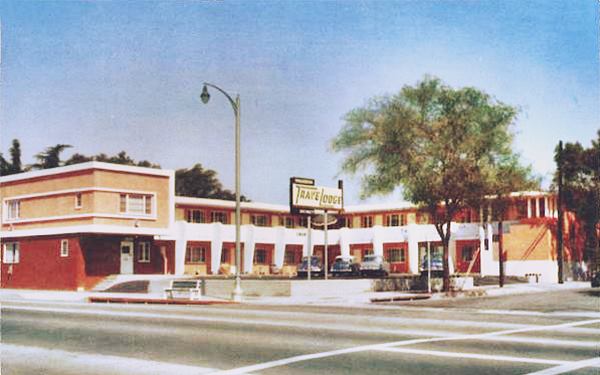
Kitty corner from the Chalet Motel was the Pasadena Travelodge. Its postcard announced that it was "On the Boulevard of the Rose Parade. Recommended by AAA, Duncan Hines, Automobile Club of Southern California." Located on the NW corner at 2767 E Colorado. It was torn down in 1997.
There were two gas stations in the 1959 phone directory at Colorado and San Gabriel Blvd. At 2717 E Colorado was Wortman & Son Richfield service station ❌, now a Seven Eleven. And opposite at 2716 E Colorado was George W. Capesius Shell Station; and there still is a Shell on this SE corner.
House of Wong ❌
On the NW corner with N San Gabriel Blvd. at 2689 E Colorado was the famous House of Wong and it appears listed in the 1959 telephone directory at this address. Next door at 2687 was Betty Ann's Sandwich Stand ❌; both buildings have gone. Below is a view of House of Wong at this location. It was ran by Ben Foon Wong and had been in Pasadena since 1934. Later in the 1960s, Wong moved to 2475 E Colorado, on the NW corner with Altadena Dr. neither location has survived. See their second location below. Click images to enlarge them.
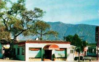
House of Wong. First location. 1930s. Pasadena. Source
Click image to enlarge
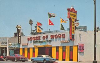
House of Wong. 1960s location. 1930s. Pasadena. Source
Click image to enlarge
Denny's c.1960s
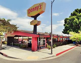
Two blocks west, on the NE corner with N Vinedo Ave. (2627 E Colorado) is an originalDenny's with its classic "Boomerang Roof", a design from the early 1960s by Armet & Davis.
On the next block at 2556 E Colorado the 1959 telephone directory lists the Chinese restaurant Look Far Low ❌a that sold "Chinese Foods - Served Family Style or To Go."
Whistle Stop Model Trains
Historic neon sign
This model train hobby shop opened back in 1951; it appears in the 1959 telephone directory (see ad below) when it was at its original location, 1.5 miles furthe east at 3745 E Colorado. ed and Irene Hakkinen owned it. Fred and Brian Brooks bought it from them in 1983. They moved to this new location at 2490 E Colorado in 1988 when their lease expired at the former site. They took the original neon sign with them and it is still affixed to the front of the building. The sign is a Locally Designated Historic Resource. 2

1959 phone book ad, Whistle Stop.Source
On the next corner was Palmer's Super Service ❌ at 2435 E Colorado, followed by Van's Shell Service ❌ on the NE corner with Sierra Madre (2371 E Colorado).
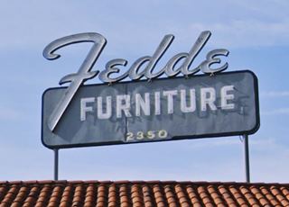
Fedde Furniture Neon Sign
Historic neon sign
Here, on the SW corner, at 2350 E Colorado is the Fedde Furniture neon sign made in 1950 is a Locally Designated Historic Resource. 2
At 2270 E Colorado was Blevins Winfield Chevron Service Stn. ❌ followed at 2239 E Colorado by Brotherson's Farm House ❌ offering "Complete Dinners - Banquet Rooms." Gone. On the next block (2159 E Colorado) was Bob Burnett's Service Station ❌.
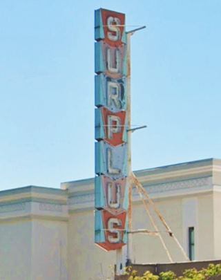
Surplus Neon Sign
Historic neon sign
To your left, at 2176 E Colorado, is the famous "Surplus" neon sign that was erected in 1953 and is a Locally Designated Historic Resource. 2
Pasadena Motel ❌
Ahead, to your right was the Pasadena Motel at 2131 E Colorado was owned by Mr. and Mrs. Al King was an "Official AAA member," it was torn down in the 1960s to make space for the current Travelodge that stands on the property.
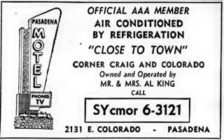
1959, Pasadena Motel ad. Source
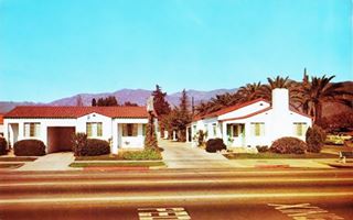
1950s postcard Pasadena Motel. Source. Click image to enlarge
Dino's Italian Inn (closed)
To your right, at 2059 E Colorado was Sang's Inn ❌, and next to it at 2055 E Colorado Mike Scarantino opened Dino's in 1949. This was the oldest Italian restaurant in Pasadena. It closed in 2006 and the founder's great-nephew decided to keep it going under a new name: Scarantino's Italian Inn. It closed for good in 2008, but the original building is still standing (St. view).
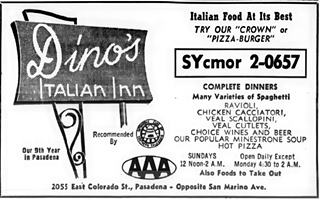
Dino's 1959 phone directory ad. Source
Click image to enlarge
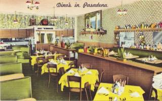
Dino's 1940 postcard. Source
Click image to enlarge
Cameron's Seafood Neon Sign
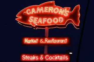
Cameron's fish-shaped neon sign. Source
1978 E Colorado Blvd. on the SW corner with S. Berkeley. This restaurant opened in 1984, many years after Route 66 was decertified in Pasadena. It closed due to the covid-19 pandemic.
Across the street at 1981 E Colorado was Elmer's Chevron ❌, now a parking lot.
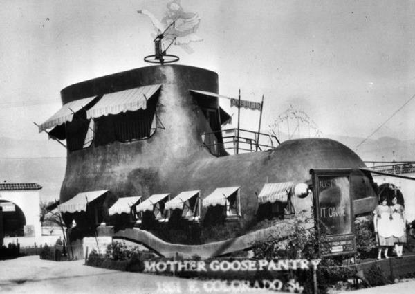
Mother Goose Pantry ❌
Located at 1959 E Colorado it was the Mother Goose Pantry was a restaurant in the shape of a Mother Goose shoe. It refers to the Mother Goose nursery rhyme: "There was an old woman, who lived in a shoe; she had so many children, she didn't know what to do. She gave them some broth, without any bread; she whipped them all soundly, and sent them to bed." This spot was the solution to her dilemma, now, with this pantry everyone could be fed.
The restaurant had a ground floor and upstairs dining areas. The building survived into the 1940s before being torn down.
Another wacky sight on Route 66.
Timmons & Prosser (Tires)
At 1915 E Colorado was Anderson's Richfield ❌ and ahead was Timmons & Prosser store at 1880 E Colorado. They are one of America's oldest tire distributors; they opened in Pasadena in 1929. This shop in offered retreading and recapping, wheel balancing and alignment; they were an authorized U.S. Royal distributors (1959 telephone directory ad). The building is still there, now the American Tire Depot. Below is a "Now and Then" set of pictures.

Timmons & Prosser c.1950s. Source
Click image to enlarge
Draper's Studio of Modes Art Deco Building
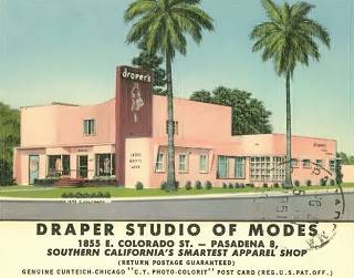
Draper's, postcard from 1951. Source
Click image to enlarge
Kitty corner from the tire shop, at 1855 E Colorado Blvd. (NW corner with N. Parkwood Ave). Draper's Studio of Modes was founded in 1925 by Virgina Christopher Draper (1895-1983). She was born in Texas, married at the age of 15, became a widow at 18 and moved to Los Angeles where she married Simeon Draper in 1921. She became a widow in 1933 and remarried for the third time in 1940 to George Christopher. It grew into a nationwide chain with 44 retail shops and catalog sales. In 2017 it closed its brick-and-mortar stores to focus on online sales.
Ms. Draper's store in Pasadena can be seen in the postcard image from 1951 where it is described as "Southern California's smartest apparel shop."
It is a good example of Art-Deco style applied to a small commercial building. Art Deco flourished between both World Wars. It was a symbol of wealth, luxury and elegance that adopted symmetry, rich colors and bold rectilinear geometric shapes to exalt the technological progress of the early twentieth century. These shapes are clearly seen in the building; below is a current view of it.
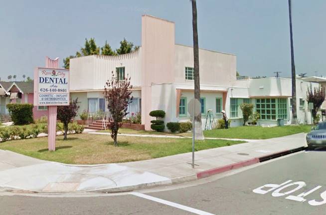
This building dates back to 1948 and replaced her original woodframe store.
Ahead was Cain's Sandwich Shop ❌ that stood at 1819 E Colorado, followed by Burdsall Automotive Service Mobil Gas ❌ at 1813 E Colorado. There still is a Mobil gas station on the property.
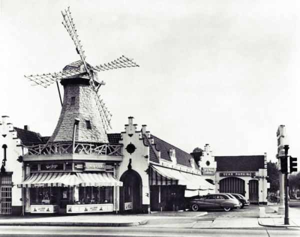
Van de Kamp's Holland Dutch Bakers ❌
The bakery had its typical Dutch windmill-styled building on the SW corner at 1696 E Colorado; it was built in 1927. The image below shows it in 1947 seen from S Bonnie Ave. with Route 66 running on the right side. Now it is a parking lot.
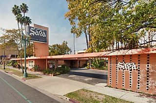
Saga Motor Hotel
Historic neon sign
1633 E. Colorado Blvd. It was "Pasdena's most convenient downtown Motor Hotel, 71 Luxurious Rooms... Color Television in all rooms... The Rose Parade Route."
Its neon sign built with the motel in 1959 is a Locally Designated Historic Resource. 2
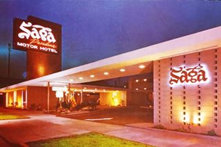
Vintage postcard, Saga Motel. Source
Click image to enlarge
Ahead, at 1415 E Colorado there was a Flying-A Service ❌ owned by Betty Virg. and on the next block there is a historic site.
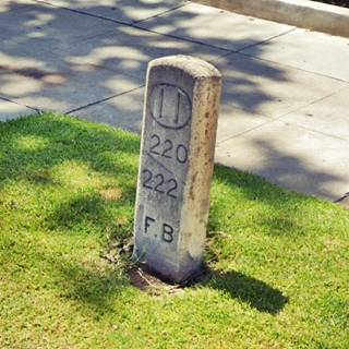
Foothill Boulevard Milestone (Mile 11)
Listed in the National Register of Historic Places
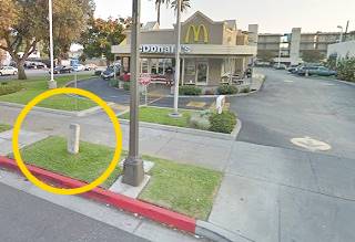
At 1308 East Colorado Blvd. On the south side of the road on the SW corner of E. Colorado Blvd. and Holliston Ave. By the McDonald's. It is a concrete marker, 3.5 ft. tall (107 cm) stuck in the grass next to the sidewalk.
It is a milepost of the Bancroft system devised by Albert Bancroft and implemented in 1892. It marked the distance in miles from the Los Angeles County Courthouse, it also indicated the block numbers. In this case 220 and 222, as subunits of the mile. It was placed there in 1902. This marking system was abandoned in 1908. This is the only remaining marker on the old Colorado-Foothill Blvd. Route.
Opposite the marker is the historic Holliston Ave Methodist Church built in 1900 by Bennett & Haskell at 1305 E. Colorado (NW corner). Further west, halfway down the block, on the north side of Colorado Blvd., a classic Route 66 auto dealership.
Howard Motor Company Building
Listed in the National Register of Historic Places
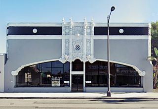
1285 East Colorado Blvd. The building was erected in 1927 on the newly created Route 66 in a spot favoured by many local automobile dealers. It was built in a heavily ornate style known as "Churrigueresque". A baroque style came from the 17th century Spain. It served as an eye-catcher for the dealership. An elliptical arch spans the facade and there is an ornamental frieze in the middle. The corners are chamfered and decorated too. See its vintage 50's postcard below and its current appearance in a "Now and Then" sequence.
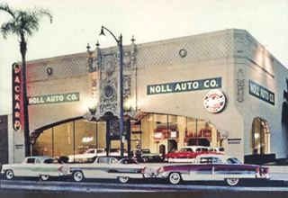
1950s postcard, Noll Auto Co. Source
Click image to enlarge
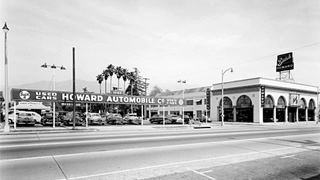
1950s Howard Used Cars Lot. Source
Click image to enlarge
In 1938, the Howard Automotive Co. moved west, to what had been the Kindel Building at 1095 East Colorado (pictured, still standing; see its St. view); this building had also been built in 1928, designed by Bennett & Haskell.
Howard Auto switched places with the Bush-Morgan Motor Company that had been there until then.
Bush-Morgan moved to the former Howard Building; they were a Packard dealership and remained at the 1285 E Colorado location until the 1950s when it Noll Auto acquired the property.
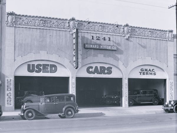
Howard also had another used auto site just down the road; below is the picture of it taken in 1939; it was located at 1241 E Colorado. It has since been torn down.
At 1242 E Colorado was the El Morro Hotel whose building is still standing. Listed in then 1959 phone directory.
Former Imperial 400 Motel
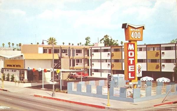
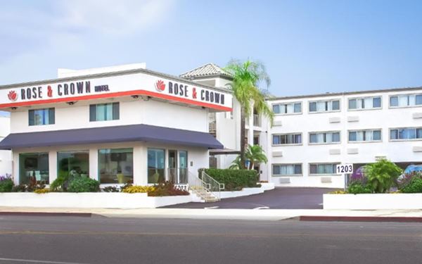
Ahead, on the corner with N Michigan Ave at 1203 E. Colorado Blvd. is a three story hotel with stucco plastering, and an L-shaped layout. Now it is the Rose & Crown Hotel but it was an Imperial 400 Motel in the 1960s.
Imperial 400 was a motel chain founded in 1959; its buildings had a characteristic "Butterfly Wing" shaped roof as shown in the postcard, but eliminated when the motel was modernized and converted into a box-lid-style roof. It went broke in the mid 1960s and sold out to new owners.
Imperial '400' Motels and Route 66
Learn all about these Space Age motels along U.S. 66.
> > Read more: Visit our Imperial "400" Motels on Route 66 webpage.
Andy's Coffee Shop
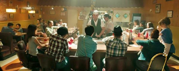
Ahead, to your left, at 1234 E Colorado. Built in 1906, it appeared in the 1959 telephone directory as Cain's. It has appeared in several movies and TV shows (Mad Men, The Fast and Furious 4) it was also featured in the music video Cups (2012) performed by Anna Kendrick. St. view. See the Cups video; the image below is from 3:16 min. in the video.
Scene shot in Andy's. Cups video by Anna Kendrick.
Michael's Store
Designated Historic Neon Sign
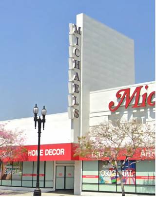
At 1155 E Colorado, adjacent to the former Imperial 400 hotel is Michael’s Arts and Crafts Store. It that was built in two phases, the first one was the western wing, constructed in 1939 using a vernacular commercial building design by Frederick Marsh. The second, eastern one, was a Streawmline Moderne styled design built in 1945 by Bennett & Bennett.
The sign has been designated as historic; it was built in 1950 for Parker's Office Supply. They had their main offices at 840 E Colorado 3
Attached to the front of the building it projects like a wall above the roof, and its letters protrude forward like fins or flags.
The City is considering a redevelopment project that will raze the building (which had been evaluated in 2022 but not considered to have historic value) but the sign will be preserved and incorporated into the new development. 1
Allied Auto Supply sign
Designated Historic Sign
Allied Auto Supply at 1060 E. Colorado Boulevard (to your left) stood next to Tracy's Steak House (1076 E Colorado). The sign on Allied's store is a Locally Designated Historic resource dating back to 1952. 2
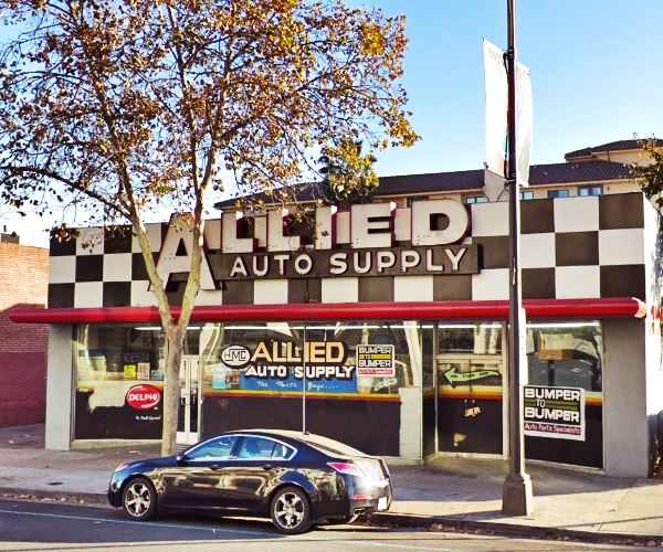
Downtown Pasadena
Pashgian Rugs sign
Designated Historic Neon Sign
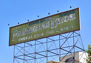
On the rooftop at 993 E Colorado, facing west, is this historic sign built in 1928. Pashgian Brothers owned an oriental carpet store established in 1889 and operating in Pasadena since 1903. Faded and weathered it reads "Pashgian Bros. Oriental Rugs · Fine Carpets."
Ahead was the Mentor Hotel at 959 E Colorado, whose building is still standing (St. view) followed at 940 E Colorado by the long gone Fifield Pasa Hotel ❌
Constance Hotel
Next, at 928 E Colorado is the historic Constance Hotel built in 1926 and designed by McNeal Swasy for Ms. Constance V. L. Perry. Later it became an assisted living facility for seniors. Closed in 2007, reopened in 2014 after a massive restoration. It went under during the pandemic in 2020. Reopened in 2022 as the Pasadena Hotel & Pool.
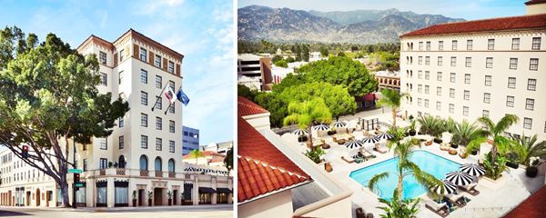
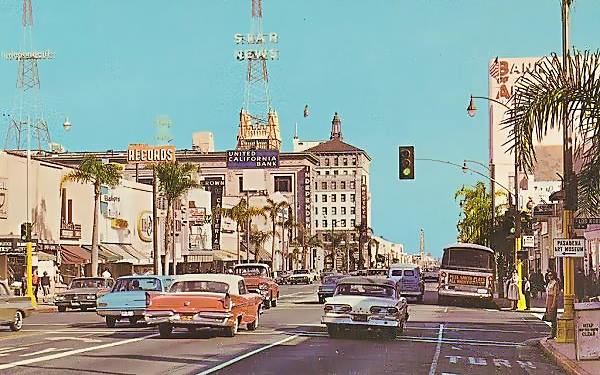
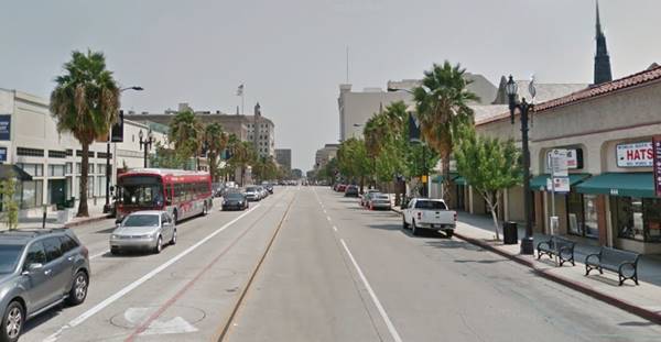
The downtown district of Pasadena has changed considerably since the Classic Route 66 days as the "Now & Then" pictures below show.
Early 1960s postcard view of Route 66 in Pasadena looking east from Los Robles St. and E. Colorado Blvd. (Route 66)
View from the same spot nowadays
Canterbury Records
At 805 E Colorado, the vintage sign is an eye-catcher for Canterbury Record Shop. Leonard Gordon opened it in 1956 with a retail outlet in San Gabriel and wholesale at Alhambra, and it has been at this location since 1960; he partnered with his sister Jennie Freedman. Still going strong outliving Route 66 and Tower Records!
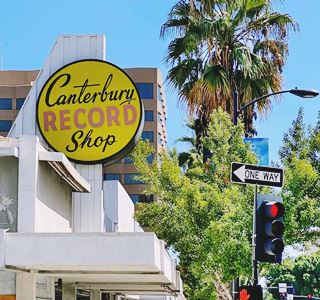
Canterbury Records sign, Pasadena. Source
Click for St. view.
United Artists Theater
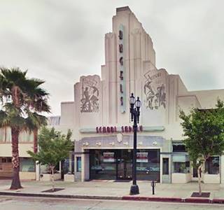
At 606 E Colorado, it opened in October 1931 and could seat 912 viewers.
Built with an imposing Art Deco style with a vertical tower centered on its facade.
It closed in 1990 and was later repurposed as retail stores and a restaurant. Its tower was shortened, but it retained its bold geometric lines.
Compare the "Then and Now" view; below is a picture from 1931.
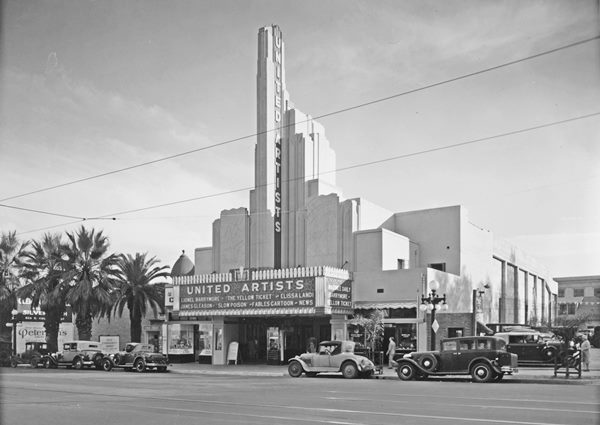
Fork in Route 66
At 150 E Colorado, U.S. Highway 66 forks (learn more in our Map and alignments of US 66 in Pasadena section). The 1940-64 Route 66 runs south along Arroyo Parkway while the 1926-40 U.S. 66 and 1940-1964 Alternate 66 continue straight along East Colorado Blvd.
We will cover the Original alignment along Colorado first, and then the Arroyo Seco Parkway alignment.
Original 1926-40 Route 66 and 1940-64 Alt 66 alignment in Pasadena
Across the Arroyo Seco
The Santa Fe railroad tracks crossed Colorado half a block west of the Arroyo Seco Parkway, between the Parkway and S Raymond Ave (100 E Colorado). Now the tracks carry the Metro's Gold line and run beneath the street. The old right of way became the Big Bang Theory Way, a pedestrian alley, that commemorates the hit TV series set in Pasadena.
The picture below shows the Chief, a named passenger train of the Atchison, Topeka and Santa Fe Railway that linked Chicago, Illinois with Los Angeles. It ran from 1926 until 1968. This image looks east along Colorado at the Chief heading from LA to Chicago. Compare it with the current view (click color image for St. view).
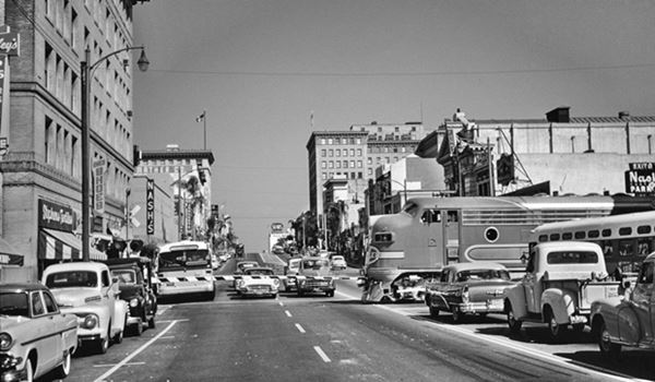
One block west is Fair Oaks Ave. that carried the National Old Trails alignment to South Pasadena and Los Angeles. It served as an alternative route for traffic heading into LA along Route 66.
35er Bar
Just before reaching Fair Oaks Ave. to your left is the 35er Bar at 12 E Colorado; family owned and operated since 1963. Set in a building that was remodeled by Frederick Marsh in 1929 with an Art Deco facade topped by a frieze (St. view).
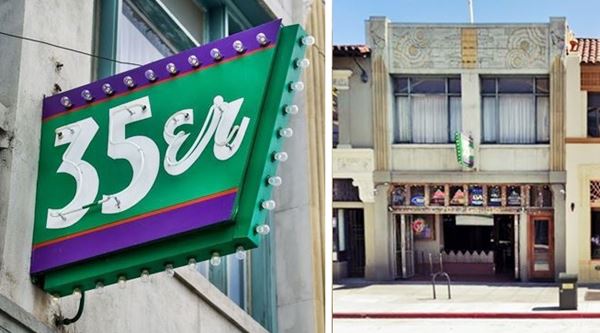
There are no Route 66 landmarks along Fair Oaks except for one, 0.6 mi. south of Colorado; a historic rooftop sign.
Bekins Storage Co. Roof Sign
Listed in the National Register of Historic Places
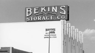
1997 original Bekins sign. Source
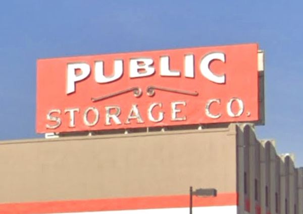
At 511 South Fair Oaks Ave. to your left, you can't miss it.
The sign which is 32 ft. long and 12 ft high (9.8 x 3.7 m) reads "Public Storage Co." and is located on the rooftop of a building. It was placed there to be seen by all those driving down Fair Oaks Avenue. It marked the arrival of neon signs to Los Angeles and was built in 1926. It is one of the few pre-World War II sign in Pasadena. The text on the sign has been modified since it was listed in 1997 (see previous names in the black and white photograph and the 2007 St. view).
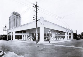
1930s Penn Oil station, Pasadena. Source
Click image to enlarge.
Return to Colorado and turn west, now it becomes West Colorado Blvd. Ahead, to your left, one block north of Route 66 is an Art Deco service station on the SW corner of DeLacy Ave. and West Union St. It was built in 1930 for the Penn Oil & Supply Co. and its 47-foot high water tower is still standing. Now it is a store. See its current St. view.
Cross the Long Beach Freeway, built in the early 1970s. It razed several buildings: Dayton Tires ❌ at 163 W Colorado and classic auto dealers like Uptown Chevrolet ❌ dealership, 245 West Colorado, and Pelton Motor Company ❌ dealing in Oldsmobile-Marmon at 254 West Colorado, and to your right is a classic automobile dealership.
Ahrens Ford
A. R. Ahrens Ford and Service was located at 285 W Colorado. The building with its wide and tall windows with curved or flat uppers is still standing. The picture shows it in 1936 and the car on the trailer is a Ford Fodor sedan with a V-8 engine.
Previously it had been Walter M. Murphy Motors Co. selling Essex and Hudson in the 1920s.
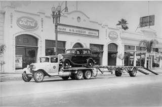
1936, Ahrens Ford Dealership, Pasadena. Source
Click image to enlarge.
Ahead was Frank J. Miller's the Lincoln Agency of the 1920s that became the Earley-Bassett Company ❌ selling Chrysler, at 362 West Colorado. The street climbs a hill rising 150 feet above the city to the east. At its summit, Orange Grove Ave runs with a north-south course. Here on the NE corner of the intersection is the Memorial Flagpole a tall flagpole with a bronze sculptured base it is a memorial to the Pasadena men who gave their lives during World War I. It was dedicated in 1927 (St. view). This area was known as Carmelita Park it encompassed the gardens of Jeanne and Ezra Carr's home who purchased 42 acres of land here in 1877.
Colorado Street Bridge
Listed in the National Register of Historic Places
Ahead the street heads down towards the deep cut of the Arroyo Seco River where a bridge was erected in 1913 to replace the burdensome downhill and uphill route across the steep slopes of Arroyo Seco River gully.
Arroyo Seco
Arroyo Seco (Spanish for "Dry Stream") is a temporary river, dry most of the year, that is almost 25 mi. long (40 km) running from the San Gabriel Mountains in the north to its confluence with the Los Angeles River by the old Route 66's Figueroa St. tunnels at Elysian Park in Los Angeles.
It was a natural route from Los Angeles to Pasadena and was used by the railroad, the electric trolley, and the Arroyo Seco Parkway, the first freeway in LA, was built in 1940 as a parkway along its souther section.
The curved bridge allowed it to find adequate solid support in the weak soil of the river bed. Its concrete arches rising 150 ft. above the river bed made it the highest concrete bridge of its time.
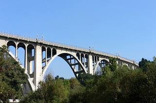
Colorado Street Bridge, Pasadena. Source.
The bridge had two lanes and was 28 feet wide plus plus the 5 ft. sidewalks on each side.
It soon became famous as the "Suicide Bridge" for those jumping off the bridge to commit suicide. The first person jumped off it in 1919. During the Great Depression many committed suicide on the bridge, and the death toll
is probably more than 100. Ten-foot high fences line the bridge as a dissuasion for suicide attempts off the bridge.
After the Loma Prieta earthquake (1989) it closed for safety reasons and was renovated, reopening in 1993.
The eastern approaches were modified when the ramps at Ventura Freeway's Exit 13A were built in the early 1950s. The current westbound exit lanes of the bridge mark the original course of Colorado Street as it crossed it and headed west into Eagle Rock from Pasadena.
This bridge carried Route 66 from 1926 to 1940 until the Arroyo Seco Parkway was completed in 1940 to relieve traffic along the by then congested bridge. It later carried Alternate 66 until it was decertified in 1964.
The western terminus of the bridge was altered by the construction of the Ventura Fwy. as the original W Colorado Blvd. ran along what is now N Linda Vista Ave. and the Westbound lanes of the freeway. The green line in our custom map shows the original course of W Colorado. Later, after the Ventura Fwy was built, it moved to the current course (violet line).
Rite Spot: Where Cheesburgers were invented ❌
Historic Landmark plaque
The marker is at 1500 W Colorado, see this map showing where it is. Set on the ramp by the sidewalk. The marker was dedicated in 2017.
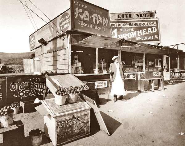
Herman Sternberger, pictured above, opened his orange juice and soft drink stand in 1919 at the crest of W Colorado by Avenue 64 in Pasadena (1500 W Colorado St.), right on the western border of Pasadena and what then was Eagle Rock (a town annexed by Los Angeles City in 1923). He had moved with his family from New York to California in 1912. His twin sons Lionel (1907-1964) and Van (1907-1968) worked at the stand.
It was here that Lionel invented the cheesburger. The story according to the marker is that he burned one side of a burger in 1924 and that he added a slice of cheese to cover the charred patty. The dish was a success and they added it to the menu as the "Aristocratic Burger." The cheeseburger had been born.
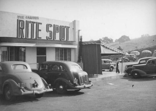
However, an article in the June 23, 1931 issue of the Pasadena Post 4 gives a different version of the invention of cheesburgers:
One day a friend told him he ought to sell something different. Together the pair "invented" a new hamburger sandwich, which included a slice of cheese, a food never before tried in such a sandwich. It was very tasty.
However, the restaurateur was afraid to feature it, owing to the additional cost involved by the use of cheese. When two old customers ordered sandwiches the next day, he tried the new idea on them. It took. Pasadena Post June 23, 1931
The Sternberg brothers went into the restaurant business in 1922, and by 1931 their Rite Spot chain of restaurants had two locations in Pasadena, another in Highland Park, Los Angeles and a fourth spot in Glendale. 5,6
In 1936 they met Harry B. Carpenter who had recently split from his brother Charles with whom he owned the Carpenter's restaurants chain in Los Angeles. Harry went on to open three Carpenter's Cafes and with the Sternbergers he co-owned a spot at 606 E Colorado St. in Glendale known as Carpenter's Village with a Rite Spot Cafe and a Carpenter's Drive In.
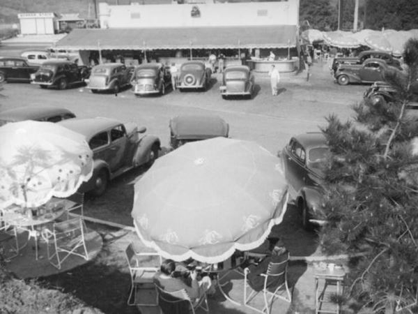
West of this point you enter Eagle Rock in Los Angeles, that we describe in the The Eagle Rock Alignment section of our Los Angeles webpage.
1940-64 Route 66 Arroyo Seco Parkway alignment in Pasadena
South along the Parkway
Originally named Broadway, South Arroyo Seco Parkway or Historic Route 66 was the alignment that led into downtown Los Angeles using the first freeway of the West. Its northern part is a regular avenue with two lanes in each direction after two blocks you reach the classic skating rink. Further south it becomes a freeway.
Pasadena Winter Garden Skating Rink
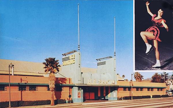
To your right, at 171 S Arroyo Pkwy. The Pasadena Winter Garden was built in 1940 in Art Deco Style, as you can see at the main entrance that is flanked with two stylized columns flank it, with bold geometric designs. Open year round it had an ice surface of 105 x 200 fett. It was here that Olympic and World champion Peggy Fleming (b. 1948) began her skating career. The rink closed in 1966 and now is a storage facility. Below is a "Then and Now" view.
Former Arroyo Sojourn Motor Inn
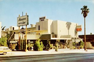
The Arroyo Motor Inn, late 1960s postcard. Source.
Click image to enlarge.
Ahead, to your left at 400 South Arroyo Parkway is a motel built in 1962 it was the Arroyo Sojourn Motor Inn. Now it is the Pasadena Inn and still operating as a motel. Its postcard announced that it had "CONFERENCE ROOMS - BANQUET - COCKTAILS - 24 HOUR RESTAURANT. All new, centrally located, minutes away from Los Angeles, Civic Center, Dodger Stadium, Rose Bowl, Santa Anita Race Track, Soundproof Rooms, TV, 24-hour switchboard, refrigerated air-conditioning, heated pool." This is its St. view.
Arroyo Seco Parkway
You can continue south along the westbound lanes and drive the Arroyo Seco Parkway into Los Angeles. It begins in Pasadena and continues through South Pasadena into Los Angeles, after Glenarm Street it becomes a divided freeway.
Listed in the National Register of Historic Places. National Civil Engineering Landmark. National Scenic Byway. California Historic Parkway.
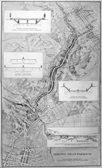
Arroyo Seco Parkway 1936 map rendering. Source.
Click image to enlarge.
The use of automobiles in LA had grown considerably in the 1920s and the main streets were constantly congested. The north-south links were limited and packed with vehicles. The city had to evolve, so it planned a new layout around the car. This led to the planning and building of the First Freeway in the West.
The first step was to use the land on the western side of the Elysian Park to build a new throughfare, the four lane Figueroa Street extension, from downtown LA to San Fernando Rd. This would then continue norhtwards using the vacant land along the dry riverbed of the Arroyo Seco River.
It was designed in a period when freeways were unknown; inspired by the German Autobahn but in an urban setting. It is a blend of a "freeway" and a "parkway". The freeway elements are the graded overpasses, the high-speed and limited-access road with on and off ramps. The parkway design can be seen in the landscaping and the fact that it ran through a parkland.

The image above looks south along the freeway from the Orange Grove Ave. brige in South Pasadena. Notice that the roadway had asphalt and portland cement concrete pavements side-by-side. They served as visual guides for the drivers to stay in their lanes and also for comparison purposes of how they performed. Compare it with the same view from the same spot, nowadays.
It had 6 lanes and was designed for 27,000 automobiles per day (it now carries over 120,000 cars daily).
It was the second superhighway in the nation, preceeded by the Pennsylvania Turnpike, a tollway that opened on October 1, 1940. It is the first freeway in America when it opened on December 30, 1940.
>> Learn more about the Historic Arroyo Seco Parkway
Some More Attractions in Pasadena
Besides its Route 66 attractions, the town is also home to the California Institute of Technology (Caltech) ad the Jet Propulsion Laboratory. Mount Wilson Observatory was established nearby in 1904. It was also a place where the rich and famous met in the early 1900s.
Classic early 1900s Hotels & Resorts
The 1915 U.S.G.S. geologic survey along the Santa Fe Railroad mentioned that Pasadena was located in a "corner" between the San Gabriel Range, and the San Rafael Hills, that protected it from cold winds and caused more rainfall in the area, making it an attractive sunny winter resort. This was the reason that hotels like the Raymond on Raymond Hill in South Pasadena and the Huntington were built in this area ; they were resorts with swimming pools, horse riding, and golf courses in the early 1900s.
Only two hotels from this era have survived: the Green Hotel (99 S Raymond Ave, built in 1893 and a co-op since 1926), and the Vista Del Arroyo now a U.S. court of law at the Arroyo Seco. The Maryland Hotel at 411 E Colorado was torn down.
You can visit them in a short tour shown in the following map with directions starting out from Colorado and Arroyo Seco Parkway.
Millionaire's Row Mansions
A short 1.5 mile tour visiting two mansions in western Pasadena (this is the Map with directions).
The Gamble House
Listed in the National Register of Historic Places, California Historical Landmark
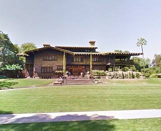
At 4 Westmoreland Pl, Pasadena. Built in 1908 by architects Charles and Henry Geene for David Gamble, who was the son of James Gambler, of Procter & Gamble the large consumer products manufacturer. It is an outstanding example of American Arts and Crafts style architecture. It is open to the public, and a museum. Read more at Gamble House's website.
The Rose Bowl
From here you can take a short 1 mile side trip north (Map with directions) to visit the Rose Bowl.
National Historic Landmark
 >
>
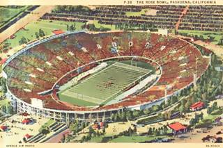
The Rose Bowl postcard c.1940s
Located at 1001 Rose Bowl Dr, Pasadena. It is the venue of the first post-season college football game, the Tournament of Roses Rose Bowl Game, played on New Year's Day, for which it is named.
It opened in 1923 and can seat 96,400 spectators; it has served as the home stadium of the UCLA Bruins football team.
Wrigley's Mansion
Now head south along Orange Grove all the way to Wrigley's Mansion at 391 S Orange Grove Blvd. This was the home of chewing gum tycoon, William Wrigley Jr. It was given to the city of Pasadena after the death of Mrs. Wrigley in 1958 so that it could become the permanent headquarters of the "Tournament of Roses Parade". See this St. view of the Mansion.
Tournament of Roses Parade
Held on New Year's Day every year since 1890 when it was created after the flower fetes in Nice, France, to celebrate the midwinter blooming flowers in California. It later became the "Rose Parade" with floats covered with flowers, leaves and seeds. The parade lasts for 3 hours and the floats cover 5 miles (8 km) along Colorado Boulevard.
End of this leg of yor Route 66 road trip. This completes the drive through Pasadena
Continue your Road Trip
Head west to continue your Route 66 road trip in neighboring South Pasadena.

Sponsored Content
>> Book your Hotel in Santa Monica

Credits
Banner image: Hackberry General Store, Hackberry, Arizona by Perla Eichenblat
A Guide to the Golden State; Federal Writers' Project of the Works Progress Administration, Hastings House, New York, 1939.
Jack DeVere Rittenhouse, (1946). A Guide Book to Highway 66.


