Your Route 66 Road Trip in Caffeyville
Index to this page
- About Caffeyville
- Weather
- Hotels close to Caffeyville
- Map of US 66
- What to see and do in Caffeyville
About Caffeyville Missouri
Facts, Trivia and useful information
Elevation: 1,397 ft (426m). Population n⁄a (2024).
Time zone: Central (CST): UTC minus 6 hours. Summer (DST) CDT (UTC-5).
Caffeyville is a tiny unincorporated community on the old alignment of Route 66 in Laclede County at I-44 Exit 123, south central Missouri.
History of Caffeyville
Read about the region's history in our Lebanon page (County seat, 6 mi. north of Caffeyville).
Laclede County was created in 1849 and named after French explorer Pierre Laclède, the founder of St. Louis. In 1870, the South Pacific Railroad laid its tracks just west of Caffeyville and the area was sparsely settled.
The original Native American trail along the divide in the Ozarks was known as the "Great Osage Trail" (after the Osage natives). During the Civil war period, a telegraph line was laid from St. Louis Missouri to Fort Smith in Arkansas and was known as the Wire Road. Later the line was removed and it became State highway 14. This road was later improved and became U.S. 66.
Traffic flowing along the new highway attracted entrepreneurs and one of them named Jessie Floyd Caffey owned a gas station here.
The name: Caffeyville
Named after Jessie F. Caffey, an Irish surname that derives from "Cobthach Fionn" ("Victorious" and "fair"). Later deformed to Coffey, Caughey, Caffey.
It thrived with some cabins and gas stations until Route 66 was upgraded, widened and straightened from Lebanon to Strafford in the 1950s. By 1956 work reached Caffeyville and the buildings were demolished to make space for the exchange and overpass. This marked an end to the town, as the traffic now flowed swiftly along the freeway. Later US 66 was absorbed by I-44 and decertified.
Getting to Caffeyville
Reach the area using US 160, 60 or 65 which run to the west through Springfield and then head east along US 66 or I-44.

Where to Lodge in Caffeyville, Missouri
There are no hotels in Caffeyville, but you can find your accommodation nearby in neighboring Lebanon.
> > Book your hotel in Lebanon
More Hotels close to Caffeyville
There are several hotels in the area close to this town. Alternatively you can also find your accommodation along Route 66 in the neighboring towns and cities in Missouri. We list them below (from east to west):
On Route 66's Main alignment in MO
Eastwards
Westwards
- Hotels in Kansas
- Baxter Springs KS
- Galena KS
- Riverton KS
- Hotels in Oklahoma
- Miami OK
>> Check out the RV campgrounds in Caffeyville
Weather in Caffeyville

Location of Caffeyville on U.S. Hwy. 66
Caffeyville clearly defined seasons: The summer (Jul) average high is 88°F (31.2°C) and the average low is 67°F (19.2°C). The winter (Jan) average high is 42°F (5.6°C) with a below freezing average low of 21°F (-6°C).
Rainfall averages 45.3 in (1151 mm) yeary fairly stable across the year (ranging between 2 in per month -50 mm- in Jan and Feb, to 5,67 in. in May. -144 mm). Snowfall is around 9 in. (23 cm), and falls between Dec. and Mar.
Tornado risk
Caffeyville is located in the "Tornado Alley" and Laclede County has around 8 tornado strikes per year.
Tornado Risk: read more about Tornado Risk along Route 66.
Map of Route 66 in Caffeyville MO
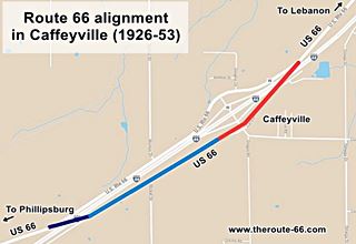
The original 1926-53 alignment of US 66 from Lebanon to Caffeyville followed the course shown in this map of US66 Lebanon-Caffeyville.
In 1952 the Missouri Highway Department started work to improve Route 66 to make it safer and shorter. It built a completely new road to the east of the original one from Lebanon to Phillipsburg. This highway had four lanes with overpasses. Its construction at Exit 123 led to the removal of most of Caffeyville's buildings. After 1958 it coexisted with I-44 until it was finally decertified around 1979.
The alignment in Caffeyville itself was disrupted by the construction of the four-lane alignment of Route 66 in the 1950s. Then I-44 with interstate roadway standards replaced grade crossings with overpasses.
This zoomable map of Route 66 in Cafeyville (missing and extant segments) shows
the original 1926-50s alignment: in Red the roadway cut off by I-44 on the eastern side of Cafeyville at Exit 123, it is followed by a section of the original alignment that runs on the
south side of the freeway (Pale Blue), passing by the stone Liberty Church.
Then it is cut once more by I-44 as it takes an east-to-west alignment (Blue line) to cross the freeway and reappear on its north side.
The Route 66 alignment in Caffeyville
Visit our pages, with old maps and plenty of information about US 66's alignments.
- Springfield to Joplin (next)
- Rolla to Springfield (Caffeyville's)
- Gray Summit to Rolla (previous)
Route 66 Sights in Caffeyville
Vanished hamlet on Route 66
Historic context, the classic Route 66 in Caffeyville
The 1946 book by Jack DeVere Rittenhouse, "A Guide Book to Highway 66" gives us a good idea of the Mother Road during its heyday. And Rittenhouse did mention this town, although he spelled the name incorrectly (as "CHAFFEYVILLE", adding an "H" to it).
... is CHAFFEYVILLE, a small hamlet consisting chiefly of a gas station, cafe and a few cabins Rittenhouse (1946)
It was preceed (1 mi. east) by "gas station and cabins."
Tour the route 66 landmarks near Caffeyville
1922 Brush Creek Bridge
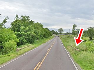
Starting out from Lebanon, the first Route 66 sight is the old Slab Bridge across a branch of Brush Creek. It was built in 1922 and still carries traffic.
It is 1.3 miles south of I-44's Exit 127 (map).
Ahead is Dover Rd. that leads to the old village of Brush Creek (right), and to your left was the site of "Bungalow Inn" that was torn down when the four-lane alignment (now buried under I-44) was built in the 1950s.
Drive one mile to see the site of the old McClary Motel & Cafe.
McClary motel cafe and service station
To your right, at 18651 Route 66, on the north side of the road.
The place is now a private residence. It was operated by McClary until the freeway opened which led to a drop in traffic and customers and eventually they closed.
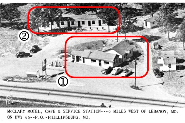
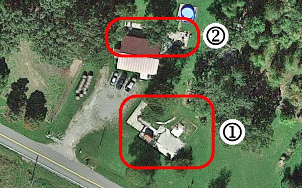
The images below show a postcard ca. 1940s and its current satellite view. Number (1) shows the former café building with the gas pumps to the left, which was still standing until recently (2014 street view), now only the foundations remain under the new building. Behind it was the motel marked (2), now gone, but as you can see in the satellite view, the concrete foundation survived, behind a modern building.
Caffeyville
Ahead the highway curves to the right to meet the overpass at I-44's exit 123. The original alignment kept a straight course. Cross the freeway to meet it on the south side of the Interstate.
The village of Caffeyville was located where the exit is, and it was razed to make space for the ramps.
Jesse Floyd Caffey (1892-1980) also known as "Toggy" began selling ice to travellers along the dusty dirt surfaced wire road in the late 1910s. He had married Pansy Vernon and later bought a store along the old road in what was then called "Oak Grove". He also pulled out the cars from the mud using a team of mules.
Learning that a modern highway (Route 66) would be aligned through the area, he moved half a mile to the new route after trading some land with his brother-in-law.
His store grew, as he added a cafe and a first filling station. The name "Caffeyville" was suggested by a lawyer, Claude Mayfield shortly before Route 66 was ceertified. Business grew and Caffey added another gas station followed by a camping area, garage and cabins.
The complex was located facing what is now "Boat town Brewing", between the entry ramp and Campground Rd. There was a gift shop facing it, "Kay's Gift Shop"; W.A. Kay owned it. But both properties were torn down in 1957 to make space for the freway.
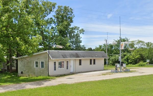
Old Gas Station
After crossing I-44s overpass, turn right and drive west along the freeway's south frontage Rd. just ahead is a former service station.
Head west, passing an interesting antique store (right) and the Liberty Church, that has been on this site since 1907. The current building was built in the 1950s (street view).
Just ahead, Route 66 took a western course, now cut by I-44. Your city tour of Caffeyville ends here. Head back to Exit 123, cross to the north side of the freeway and continue your Route 66 road trip by heading west to visit Phillipsburg.

Some sponsored content
> > Book your Hotel in Lebanon

Credits
Banner image: Hackberry General Store, Hackberry, Arizona by Perla Eichenblat
Jack DeVere Rittenhouse, (1946). A Guide Book to Highway 66


