Sampson MO
Index to this page
About Sampson Missouri
Facts, Trivia and useful information
Elevation: 1,381 ft (421 m). Population n⁄ (2010).
Time zone: Central (CST): UTC minus 6 hours. Summer (DST) CDT (UTC-5).
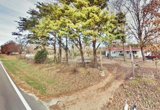
Sampson is ghost town in northern Webster County, in south central Missouri. At the junction of Mo. Highways CC and HH.
History of Sampson
Read about the region's history in our Marshfield page.
The name: Sampson
Named after the Sampson family who opened the post office. Sampson (and similar surnames Sanson, Sinson, Sansom) were brought to England from France and derive from the biblical name "Samson" which comes from the Hebrew word "shemesh" or "sun".
The area was surveyed in 1870 by the South Pacific Railroad Co. but it had been settled earlier, in 1862 when land was granted in the area. At that time Charles Atteberry opened a general store. The railroad passed through the town shortly after. A lumber company (the Ozark Plateau Tie and Timber Co.) opened in 1909 and sent logs via a railroad spur into the town. There were dozens of canning factories in Webster County, and a large canning factory (the Case Canning Company) was in Sampson, processing tomatoes but due to safer labor requirements it closed by WW II. By then population was around 22 residents.
Route 66 was created in 1926, and passed just by the village, but Lebanon to the north and Marshfield to the south captured most of the traffic.
The post office was established here in 1907 but it closed during the Great Depression in 1935. The town gradually dwindled and now only a few residents live in the counrtyside around it.

Find your Hotel near Sampson, Missouri
Lodging close to Sampson; there is no accommodation in town, but you can find a room in neighboring Marshfield.
> > Book your hotel in Marshfield
More Lodging close to Niangua on Route 66
There are several hotels in the area close to this town. Alternatively you can also find your accommodation along Route 66 in the neighboring towns and cities in Missouri. We list them below (from east to west):
On Route 66's Main alignment in MO
Eastwards
Westwards
- Hotels in Kansas
- Baxter Springs KS
- Galena KS
- Riverton KS
- Hotels in Oklahoma
- Miami OK
>> Check out the RV campgrounds in Marshfield
Weather in Sampson
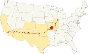
Location of Sampson on U.S. Hwy. 66
Sampson has clearly defined seasons. Its position on the northern limit of U.S.'s humid subtropical climate gives it very humid weather during late summer.
The July average temperatures (summer) temperatures are: (high) 89°F (31.6°C); (low) 68° (19.8°C). The aerage January (winter) high temperature is 43°F (6.1°C) while the average low is below freezing: 22°F (-5.3°C).
Annual rainfall averages 45.6 in. (1.160 mm), and Sampson receives about 17 in. of snow (43 cm) every year.
Tornado risk
Sampson is located in the "Tornado Alley" and Webster County has around 9 tornado strikes per year.
Tornado Risk: read more about Tornado Risk along U.S. 66.
Map of Route 66 through Sampson, Missouri

1948 USGS Map of Sampson
Route 66 Map and its alignment
The image shows Route 66 marked in red, running across the image from top to bottom, and Sampson to the right, by the railroad.
The map of US66 in Sampson shows the 1926-53 alignment.
The original roadway has a roughly north-to-south alignment from Conway, through Sampson, to Niangua and Marshfield.
In 1953 a safer and straighter four-lane
highway was built to the west of Sampson. This road is now beneath the freeway (I-44).
The alignment in Sampson
Visit our pages, with old maps and plenty of information about US 66's alignments.
- Springfield to Joplin (next)
- Rolla to Springfield (Sampson's)
- Gray Summit to Rolla (previous)
Route 66 Sights in Sampson
Landmarks and Places to See: a Vanished village
Historic context, the classic Route 66 in Sampson
In 1946, Jack DeVere Rittenhouse published his "A Guide Book to Highway 66" in which he mentions Sampson during Route 66's heyday.
Pop 22; gas; few cabins Rittenhouse (1946)
He added that it was followed two miles west by "gas station and cafe".
Thinking about visitingt Branson?
Some tours and sightseeing
Sponsored
Tour the route 66 landmarks in Sampson
"That's It" Motel Site
Starting at the Laclede County Line, at Route 66 and Webster County line road, the highway runs with a general north to south alignment. One mile ahead, to your left, facing Letterman's farm is the site of the former "That's It Motel". Nothing remains as the place burned down in the 1970s. It had been run by the Guerneys from 1948 until the 1960s.

That's It Motel postcard. Credits
Continue west for 1.3 miles, and to your right is the site of O'Brien's cafe, filling station and cabins, at 9119 Hwy CC (old U.S. 66).
O'Brien's Cabins, cafe and station
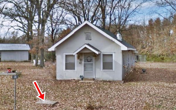
This was "O'Brien's Modern Cottages". The cabins stood on the back of the property and have been torn down, but the building that served as a café and Texaco gas station is still standing. Notice how its gable roof porch is still there.
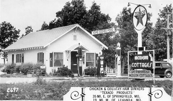
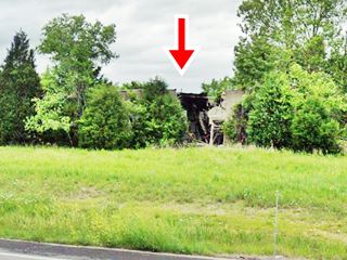
Same place nowadays, notice the concrete foundation of the gas station's sign is still there, in the lawn in front of the former station (red arrow).
Continue westbound along Route 66, after 0.9 miles you reach the junction that (left) leads to "Sampson", a few homes by the railroad track. There is no depot here. At one time there was a gas station, store and post office here, and a tomato canning factory beyond the railroad. Nothing remains.
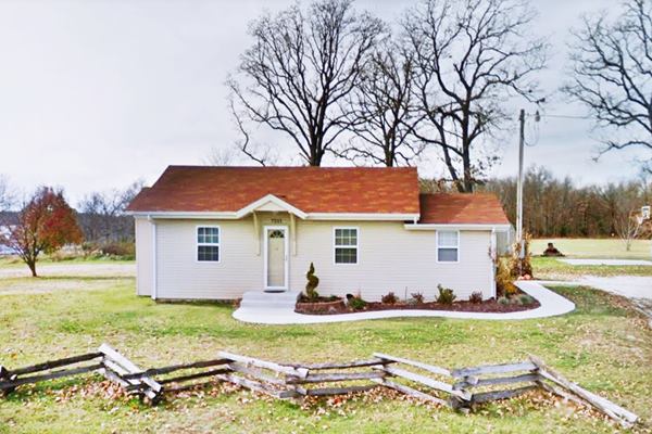
Keep southwards along U.S. 66 and one mile ahead, at 7211 State Hwy CC, Niangua is the site of the old Timber Hill Camp, an old tourist camp.
Timber Hill Camp
Also known as Indian Camp, it is now a private home, the old office and residence was a wood frame building with a gabled roof built in Craftsman style around 1930.
It was one of the many tourist camps along Route 66. By 1938 it had three cottages, with common toilets and showers. There was even an area for trailers with electricity! It was run by Florence Baldwin from 1940s to 1957 and after that by Orville Ikerd.
View of the former Oak Vale Park
This is the last site of Sampson on the 1926-53 Route 66 alignment, there is another one on the four-lane Route 66 alignment that replaced it after 1953, and is now buried beneath I-44. the "Garbage Can Cafe and Lowery's Service Station" (map with directions.)
Garbage Can Cafe and Lowery's Service Station
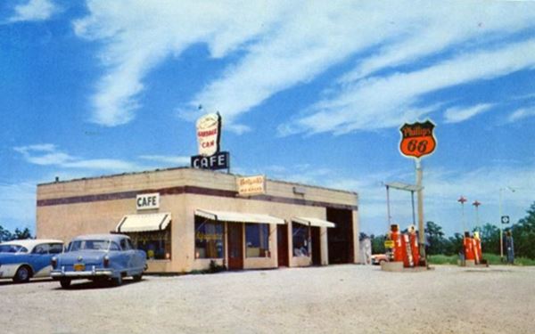
It was, according to its postcard, located on "US Highway 66, 7 miles east of Marshfield MO. & 7 miles west of Conway, MO." The box-shaped, flat-roofed building had a café and a Phillips 66 station on the westbound lanes of the new "superhighway."
Kermit and Letha Lowery ran it from the early 1950s until 1972. When the freeway replaced the original four-lane highway, an exit ramp was built in front of the property, it cut it off from the traffic and also invaded the area in the front of the property where the pumps were located. The old vacant and abandoned building is crumbling away next to the freeway. This map shows its exact location.
Old Cafe and Phillips 66 station
Your city tour of Sampson ends here, return to the Old Route 66 (map with directions) and head west along Route 66 and continue your road trip into Niangua.

Some sponsored content
> > Book your Hotel in Lebanon

Credits
Banner image: Hackberry General Store, Hackberry, Arizona by Perla Eichenblat
Jack DeVere Rittenhouse, (1946). A Guide Book to Highway 66
Architectural - Historic Survey of Route 66 in Missouri and Detailed Survey, Maura Johnson. 1993
Missouri: The WPA Guide to the "Show Me" State


