US 66 in Western Oklahoma
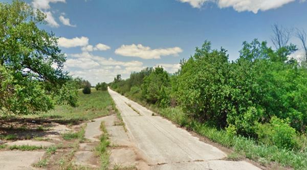
The now abandoned and closed westbound lanes of the 1956-1970 four-lane Route 66 in Hext
Index to this page

TheRoute-66.com is reader-supported. When you buy through links on our site, we may earn an affiliate commission at no additional cost to you.
About Hext, Oklahoma
Facts, Trivia and useful information
Elevation 1,800 ft (549 m). Population: not available (2010).
Time zone: Central (CST): UTC minus 6 hours. Summer (DST) CDT (UTC-5).
Hext is a very small hamlet on Route 66 in Beckham county, it is an unicorporated rural community located on the Old Route 66 (modern OK-66 State highway), between the towns of Sayre and Erick. Its population has not been recorded by the U.S. Census in the past so there is no official figure for its population.
As with most towns along Route 66 in this part of Oklahoma, the townsite was the outcome of the railway expansion westwards, into Texas. The Choctaw, Oklahoma and Gulf Railroad, later Rock Island Railroad built a line west, towards Texas and allowed settlers to reach the area.
Although it does not figure as a station on the Railway through the area in the Oklahoma and Indian Territory map of 1905, it had a post office between June 4, 1901, and November 29, 1902.
It surely lost population to nearby Sayre (8.5 mi. east) and Erick (7 miles west).
Hext the name
It was named for a prominent local resident: William Hext.
The surname Hext, is also written as Exte, Exeter and Hexter is an English "place" surname (people were named after the area they lived in). It apparently derives from either the River Exe in Devonshire or the city of Exeter.
Its meaning: it was a nickname from the Middle English word "hext" = tallest or highest, which in turn originated from Old English "hehst, the superlative of heah: "high".
It is located in Beckham county and Route 66 passes through the scattered houses that make up the "village".
It is a farming and ranch area. There are no shops or industries in the area.
Route 66 was aligned through the hamlet in 1929 (5th Street) after being upgraded from the former 1926 alignment. At that time it was paved.
In his book "A Guide Book to Highway 66", Jack DeVere Rittenhouse wrote about Hext in 1946, and depicted it as we now see it:
HEXT. Not a community - just a gas station, and an indication that from here on west many of the "towns" shown on usual road maps often contain no more than one building... Rittenhouse, 1946
By the way, the service station that Rittenhouse mentions must surely be the one we describe further down.
Where to Stay. Accommodation near Hext
Book your hotel near Hext. There are several hotels in nearby towns along Route 66
>> Book your Hotel in nearby Elk City or Sayre
Lodging Near Hext along Route 66
There are several hotels in the area close to this town. Alternatively you can also find your accommodation along Route 66 in the neighboring towns and cities. We list them below (listed from east to west):
On Route 66's Main alignment
Eastwards
Westwards
>> There are RV campgrounds close to Hext.
The weather in Hext

Location of Hext on Route 66
Check the Weather in Sayre, only 8.5 mi. from Hext.

Map of Route 66 through Hext
Below is a map below, from 1924 which shows the alignment that two years later would become Route 66. As you can see, it didn't go through Hext. Instead it took a longer course, further south between Sayre and Erick through a town called Delhi.
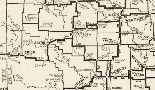
Later it was aligned along its present course and by 1931, which is the date of the map below it was paved westwards up to Erick. And from that point west into Texas, it was an "All-weather road".
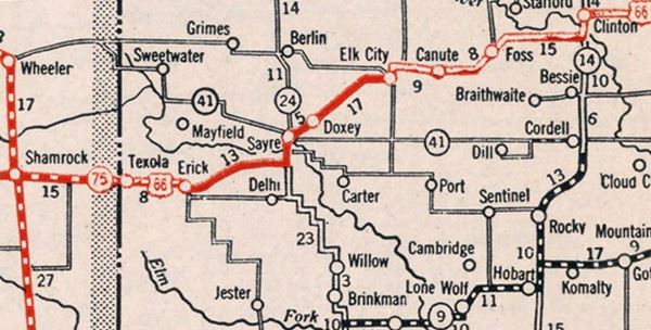
Route 66 Alignment near Hext
- Texola to Amarillo (next)
- Clinton to Texola (Hext's)
- Yukon to Clinton (previous)
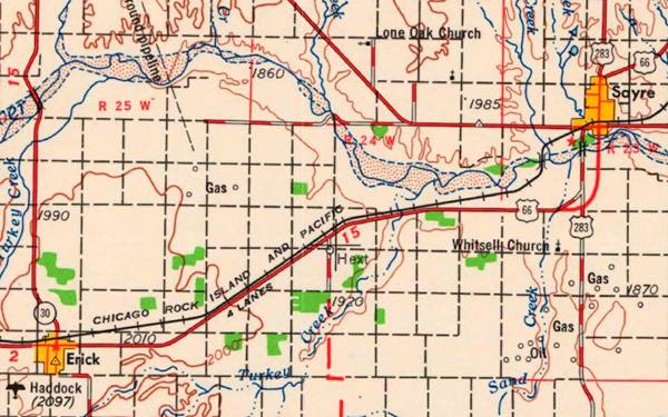
The final map shows a four-lane Route 66 (USGS 1955). Current I-40 was built later, and runs south of US 66. Click on the map to see a large size map.
Route 66 landmarks & attractions
Hext, almost a Ghost Town, its Attractions
Hext is a scattering of homes along the last section of US 66 to lose its designation to Interstate 40 in Oklahoma. See its reconverted vintage filling station and the original roadbed of Route 66.
The original roadbed of Route 66
Remains of Route 66
The original Portland Concrete road paved in 1929 and 1930 and later upgraded in 1956 can still be seen, abandoned, a few feet north of the modern road along this segment.
The original two-lane Route 66 west of Sayre was upgraded to four lanes in 1956. Later, in 1975 when I-40 opened, its westbound lanes were built on top of the two eastbound lanes of US66, leaving only the two westbound lanes which now make up the North Frontage Road.
At this point 1.5 miles west of N 1850 Rd. where the railroad and US66 converge and I-40 curves to the SW, the old four-lane alignment has survived. Though the 2 westbound lanes cannot be driven, and are partly covered by bushes and trees that have grown on it since 1970.
Here you will see, to your right the fork where these westbound lanes splits from the extant alignment.
The image shows the current and old lanes as they cross Turkey Creek.
Current two lanes and the two old westbound lanes of US66 in Hext
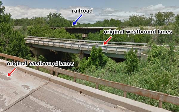
These westbound lanes run parallel to the remaining lanes that are still open to traffic. They end just east of I-40s Exit 11, where the road becomes a real four-lane highway (the original four-lane Route 66), crosses the freeway and continues like that all the way into Erick.
Abandoned lanes of Route 66 in Hext, Oklahoma
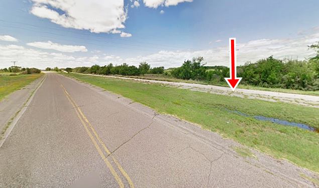
Hext Baptist Church, and the abandoned school are located to your left, along Bk 15, which leads to I-40 Exit 14. Ahead along Route 66 at E 1220 Rd. is the former gas station.
Old Service Station
On the western side of the village, on the south side of Route 66 is an old stone building belonging to a filling station whose service bay was reconverted into a house after the pumps were removed.
Former gas station in Hext
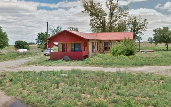
Your city tour of Hext ends here, head west into Erick.
Some sponsored content
>> Book your Hotel in Tulsa

Credits
Banner image: Hackberry General Store, Hackberry, Arizona by Perla Eichenblat
Jack DeVere Rittenhouse, (1946). A Guide Book to Highway 66.


