
Index to this page
Historic Route 66 Yukon to Clinton
Oklahoma Route 66 Itinerary and maps
Each leg of Route 66 described below has an interactive map and many image maps so you can follow the alignments of the highway along the way:
- KS-OK state line to Vinita - map of this segment
- Vinita to Tulsa - Map of this segment
- Tulsa to Chandler - Map of this segment
- Chandler to Yukon - Map of this segment
- Yukon to Clinton - Map of this segment
- Clinton to Texola - Map of this segment
Texas, next leg
Kansas, previous leg
Background on Historic Route 66
Route 66 was aligned along existing roads when it was created in 1926. In this area, all of them unpaved. The following map shows the "auto trails", or roads that were suitable for cars. It was published in 1924 and shows the options available at that time. In 1926 Route 66 followed the alignment from Yukon to Clinton, through El Reno, Calumet, Geary, Bridgeport, Hydro, and Weatherford.

It was long, had many 90° it even had a toll bridge over the Canadian River. Soon it was shortened and paved. Below is a map published in 1931; part of the alignment was paved (solid red line), the rest was an "All-weather road" unpaved.

Starting point: Yukon
We will begin our itinerary on the eastern side of Yukon. At Lake Overholser Bridge.
Route 66 from Lake Overholser to Yukon
Prior to the creation of Route 66, the road linking Yukon to Oklahoma City (OKC) was State Highway No. 3 that was paved in Portland concrete in 1923, from 39th and Penn in OKC Co. to the Lake Overholser Bridge. It crossed the town of Bethany as it headed west.
Lake Overholser Bridge

Overholser Bridge, Route 66.
Listed in the National Register of Historic Places
It is part of OKC, though it is nearer Yukon. Street View.
It combines two kinds of steel trusses: each end is a camelback Warren Pony Truss while the four central spans are Parker Through Trusses. It was built between 1924 and 1925, predating Route 66 which later incorporated it into its alignment for over three decades.
It was rehauled in 2001 and reopened to local vehicular traffic once again.
Eastwards into Yukon
The original 1926 to 1958 road is the following: From 39th Expwy, just east of North Canadian River, it headed west along what is now Overholser Drive and crossed the river along the Lake Overholser Bridge.
It curved towards the Lake Overholser (which is OKC's water reservoir) and kept along its north shore, curving again to align along NW 36th St. (in those days there was no John Kilptrick Turnpike) and Lakeshore Dr.
This road actually followed the Interurban Trolley line that linked Yukon to OKC, and that is why it curves slightly south at S. Yukon Parkway.
>> blue line in our custom map is the 1926-58 US66 into Yukon
Paving
After Route 66 was created in 1926, the Portland concrete paving was extended west for 2,500 ft. from Overholser bridge to the Canadian County line. Only in 1928 was the highway paved beyond the county line, it was surfaced with asphalt for 1.5 miles (only in 1947 would it be repaved in concrete) until it reached OK-4, where it met the concrete roadbed that had been paved into Yukon in 1926.
In 1949 the road took its current configuration west of S. Yukon Parkway, with four divided lanes, which were continued eastwards in the 1958 upgrade. Once in Yukon, Route 66 became the Main St. as a 4-lane non-divided avenue, to Garth Brooks Blvd. where once again it became a 2-lane road.
>> brown line in our custom map is the 1949-85 US66 into Yukon
The 2 lanes of the original 1926 alignment eastwards were bypassed when the highway was upgraded to 4 lanes in 1958.
>> red line in our custom map is the 1958-85 US66 into Yukon
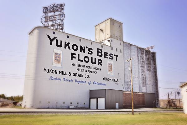
Iconic Yukon Mill and Grain Co. elevator silos, Route 66
Historic Route 66 in El Reno
>> pale blue line in our custom map is the 1926-85 Yukon to El Reno alignment.
In 1928 the road was paved in asphalt from the junction with OK-4 in Yukon to the Jct. with U.S. 81 in El Reno (map with directions Yukon to El Reno).
From here there were several alingments:
1926 to 1932
Route 66 took a 90° turn northwards along Shepard and another 90° turn west along Elm St. Both were paved in asphalt in 1929. Then it went north along Hoff and turned west on Wade; map with directions into El Reno (1926-32).
>> red line in our custom map is the 1926-32 El Reno '66
From 1932 to 1946
The highway moved from Hoff to Rock Island avoiding two right angle turns: map with directions into El Reno (1932-46).
>> pink line in our custom map is the 1932-46 El Reno '66
1946-85
In 1946 a safer and wider four-lane bypass of Shepard and Elm was completed (Now Bus. 40), map with directions into El Reno (after 1947). Then it followed the 1932 alignment into downtown El Reno.
>> bordeaux line in our custom map is the 1946-85 El Reno '66
The highway crossed the central part of the city with two more sharp turns, and left it along Sunset Rd. From there westwards Route 66 was paved in Portland concrete in 1928, for 1.3 miles; see this map with directions downtown and west of El Reno.
Heading west the highway ran along the eastbound lanes of what is now Bus. 40. At the modern Ft. Reno turnoff it followed modern E1020 Rd. (Route 66). Which was the 1926-1962 alignment all the way to US 270, map west of El Reno.
At this point is where the "loop" (later known as El Reno Cutoff) would begin.
>> green line in our custom map is the 1926-62 US66 West of El Reno
In 1962 Route 66 was aligned along the four-lane I-40 west of Exit 119 in El Reno.
1926-33 Alignment through Calumet and Geary
Instead of running straight west, the first routing of US66 turned north at US 270 and went up to Calumet and Geary.
The Calumet segment: original alignment
From 1926 to 1931 Route 66 did not follow the course of current US 270, it ran to the west of it, along what is now N. Calumet Rd. which was never paved, it was only improved with oil and gravel in 1931. It can be partly driven (yellow lines) but it has a gap (orange line) south of Darlington Rd. Map below:
>> yellow lines in our custom map are the 1926-31 driveable section. Orange line is a gap
The road was realigned and paved in Portland Concrete all the way to Calumet in 1931-32 (red line in map) and US 270 created in 1929 overlapped US 66 in this section. At Six-mile Creek there was a curve and bridge (black line) that was eliminated in 1986.
>> red line in our custom map is the 1931-33 driveable section. black line is a gap
North of Six-mile Creek the paved alignment curved NW and merged with the older unpaved alignment heading north into Calumet along Calumet Rd.
Calumet
>> pink line in our custom map is the 1926-33 US66 into Calumet
In the town there is a fork, with the 1926-29 alignment running west with many sharp turns westwards (purple line) and the 1929-33 US66 taking a straighter course.
>> purple line in our custom map is the 1926-29 Calumet Geary US66.
blue line in our custom map is the 1929-33 realignment
Calumet to Geary
U.S. 66 originally left Calumet along Todd St. There is a culvert in a field on the gap that exists between Calumet and S. Red Rock Rd. (violet marker in our map).
After 1929 and until 1933 it went from Calumet to Geary along the modern alignment of US 270 (blue line in our map).
The 1926 Road from Geary to Bridgeport
Coming from Calumet, US 66 grazed the southern part of town, taking a southward turn along Broadway (left) following it for three blocks. At the time, US 281 did not exist, so it followed the unnamed road that nowadays splits to the right with a SW course next to the railroad tracks.
Of course, the weary travelers drove north into Geary to fill up their tanks, eat or rest.
The road south of Geary was built by Oklahoma State Highway Commission between 1925 and 1926, and that year it became part of US Hwy. 66, and remained so until 1933 when the "El Reno Cutoff" bypassed it.
At the junction with N2620 Rd, it met the old 1916 Postal Route that followed the longer Ozark Trail. Here Route 66 took continued along N2620 Rd straight south along the Ozark Trail (Postal Route) that had been built in this section in 1917 by the town of Geary and improved by Oklahoma State Highway Commission; it was unpaved.
The road continued south along Lumpmouth Creek and took a right, westwards along E1000 Rd. towards Bridgeport.
>> yellow line in our custom map is the 1926-33 Geary to Bridgeport alignment
As it reached the Railway Bridge over the South Canadian River Route 66 turned left (south) and crossed the river over a private Toll Bridge, and entered Bridgeport along road that is no longer accessible from the north (the bridge is gone).
The Toll Bridge at Bridgeport
It was a common practice in the state of Oklahoma for private toll bridges to operate on highways built by the state at key rivers (Red, Grand and Canadian).
The Canadian River bridge was therefore part of this practice. The Oklahoma City businessman George Kay built the bridge in 1921 and charged $1.00 for cars and $1.50 for trucks. It was a suspension bridge, held up by cables.

Route 66 used the suspension bridge; when it was created in 1926, Route 66 was aligned along the Ozark Trails - Post Route from Geary to Bridgeport, and as expected, used the only bridge in the area: the Key Toll Bridge.

The remains of the bridge at Bridgeport, OK. Click for satellite view
However its use by Route 66 would be short lived, a new bridge was built along the upgraded alignment further east, which bypassed this former toll bridge in 1934, when it opened to traffic, the "Historic Canadian River Bridge".
The old toll bridge was washed away by the floods but the original towers can still be seen on the north bank of Canadian River, just east of the old railway bridge.
The image shows the two northern towers of the 1921 suspension bridge across Canadian River.
The road across the river using the toll bridge and into Bridgeport is marked with a violet line in our custom map; it crossed the town of Bridgeport and turned west. The later alignment meets it here, south of the town. This is the end of the Calumet-Geary-Bridgeport 1926-33 Loop.
>> violet line in our custom map is the 1926-33 US 66 in Bridgeport. Violet marker shows the toll bridge site.
The El Reno Cutoff 1932

Bridgeport Hill Service Station. Source
After 1932 the road was shortened and the Loop through Geary and Calumet was bypasse by this "cutoff". Route 66 just headed west from the junction of US 66 and US 270.
It was built as a paved road and shortened the original alignment (the "Loop") by several miles. It was originally paved in 1931-32 in Portland Concrete and was known as "El Reno Cutoff".
It headed west from US 270 and where the modern Cherokee Trading Post it took a SE-NW course, now followed by US 281 Bus. Spur. Just ahead, it then turned west along what is now "Old US 66".
>> red line in our custom map is the 1932 El Reno Cutoff (eastern part)
At the curve there is now missing curve on the south side of the highway (black in our map).
>> black line in our custom map is the gap at the curve
As you pass the curve, on to the right is the "Bridgeport Hill Service Station", built by Leroy Tiller in 1934.
Bridgeport Hill
After the filling station, the road follows a long incline known as Bridgeport Hill that heads west and descends into the Canadian River valley. For those heading east, this long incline was tough to tackle in 1930s cars and trucks.
>> pink line in our custom map is the middle part of El Reno cutoff

Lip Curbs
As concrete surfaced roads were new at that time, roadbuilders experimented. The highway had a normal edge that blended into the shoulder if the terrain was flat and level. However, when there was an incline or grade, they added "Lip Curbs".
These were sloping, curved, curbs, not the usual 90° ones. The idea was to contain any water that fell on the highway when it rained and not let it soak into the shoulder, it was conducted downhill along the edge of the highway and then drained at specific points through channels into a ditch.
These lip curbs had an unexpected consequence: they were hazardous; vehicles could flip over if they hit the curbs. So they were not included in later highway construction.
Below is a detail of how they were built.
Relict Roadbed on the western side

Click image for this satellite view of the "relict" road.
After the steep incline of Bridgeport Hill the highway turned left, southwards (where it now meets US 281) and turned left. Here is another section of the original highway that can be seen on the southeastern corner of the junction it is a strech of road 300 ft (100 m) long of the original roadbed. It can be accessed from either highway just 200 ft. short of the junction. Blue line in our map:
>> blue line in our custom map is the Old roadbed at the curve
Here at the crossroads of US 281 and old Route 66 is the eastern terminus of the intact 1931-34 alignment of Route 66, described in the next section that crosses Bridgeport and reaches Hydro. At this crossroads US 66 took a SW course heading towards the Canadian River River
Bridgeport Hill - Hydro Segment of Route 66
Old Route 66 Bridgeport Hill to Hydro, Geary to Hydro, OK.
Listed in the National Register of Historic Places
One of the longest intact segments of the original Route 66 roadbed and roadway in western Oklahoma: 19.5 miles long.
This segment begins just west of the South Canadian River bridge (described above), and heads west passing along the south side of Bridgeport and runs all the way to Hydro. It was paved in Portland Concrete in 1931, 33 and 34. It is the current alignment of OK-66.
East of Bridgeport are two bridges built in 1934.
The road in this segment bypasses Bridgeport along its southern side and keeps west towards Hydro where it ends 0.5 mi. east of Exit 84 of I-40 near Weatherford. In some spots it has been resurfaced west of Canadian River, but the rest is mostly unaltered. It has the original integral curbs and drains to help discharge rain water.
It remained operational until 1962 when I-40 replaced it. This alignment also did away with the private toll bridge just north of Bridgeport on the 1926-1932 alignment of Route 66.
1930s photo looking north along Route 66 towards the Canadian River. Click on the image to see the same view as it is today.

Historic Canadian River Bridge
Historic bridge, the longest bridge on Route 66.
Old Route 66 and Canadian River, Geary, OK.
The longest truss bridge in Oklahoma and of the whole Route 66 and was built in 1933-34.
It spans the South Canadian River in Caddo County and was built in 1934 on the upgraded alignment of Route 66 (now US 281).
Its official name is "William H. Murray Bridge", but locals know it as the "Pony" bridge. William Henry Davis "Alfalfa Bill" Murray (1869 - 1956). Was the first Speaker of the Oklahoma House of Representatives after statehood, as U.S. Representative, and the ninth Governor of Oklahoma (1931-1935).

It is the longest bridge on Route 66: 3,944.33 feet. or about 3⁄4 miles (1,203 m) long.
It cost $346,000, equivalent to $6,880,000 nowadays, and was built by the Kansas City Bridge Co.
It consists of 38 pony truss sections, each 100 feet long. "Pony" the fact that the parallel trusses are not braced at the top. (the trusses are the triangular steel structures that support the bridge on either side of the roadway.
The trusses have a "Camelback" design, because their shape has an arch-lie form which is strong and light. It was finally opened to traffic in 1934 due to delays in the Bridgeport section of US 66.
Trivia
The west end of the Canadian River Bridge appeared in the 1940 movie "Grapes of Wrath", in the scene where "Grandpa" died and was buried.
>> bordeaux line in our custom map is the 1932-62 alignment into Bridgeport
US 66 to Bridgeport and Hydro
After the bridge, the highway curves west at Hinton Junction, and after 1.7 miles meets the 1926-32 alignment on the south side of Bridgeport. Now it runs in a straight line towards Hydro
>> red line in our custom map is the 1926-60 Bridgeport to Hydro alignment
Route 66 west of Hydro has followed the same alignment since 1926. It was paved in Portland Concrete all the way to Custer Co. line and from there into Weatherford in 1931. It remained a 2-lane road until 1959 when Route 66 was upgraded to a 4-lane road. The original alignment remained as the westbound lanes of the modern highway.
As I-40 was built west of Hydro, it incorporated the two eastbound lanes of Route 66 as its westbound ones. When it was completed, Route 66 became the north service road of I-40.
The Old alignment of Route 66 near Weatherford
Route 66 followed several alignments through Weatherford.
>> violet line in our custom map is the 1926-58 Hydro-Weatherford US66
Across Weatherfford
There were several alignments across the city:
From 1926 until 1930; it entered Weatherford along E. Davis and then took a left, southwards along Washington. Where it ran west along Main St. all the way to 4th, where it turned south, headed out of town, crossed the railway tracks and then went west towards Clinton.
In 1930 it was realigned along E Main, and met the original alignment at Washington.
In 1931, the road was paved in Portland concrete from the Caddo County line into Weatherford, and frome there to Clinton. It took a new alignment, along 7th street, with a wider curve; crossed the tracks and turned west to follow the previous 1926 alignment. It used it from 1931 until 1971 . There is a missing section of the road, the one linking the 7th and 4th alignments beside I-40.
When I-40 opened in 1970 it rerouted US-66 around town in 1971, and remained on it until it was delisted in 1985.
>> alignments across Weatherford in our custom map, color key is:
Red line: 1936-30 into town. Green: 1931 realignment east of downtown. Brown: 1926-71 '66 across downtown. Yellow: 1931-71 Route 66 leaves Weatherford. Pale Blue: 1926-30 highway leaves town.
West of Weatherford the 1926 2-lane alignment had been upgraded to 4-lanes in 1962. US 66 became I-40's north service road in 1967.
East of Weatherford US66 was a two-lane road until 1959, when it was widened to 4-lanes (1959-67) they became the eastbound lanes of the upgraded US 66 and later after the completion of I-40, its north service Road.
Weatherford to Clinton
The original 1926-59 highway ran along the N Frontage Road westwards from Weatherford:
>> red line in our custom map is the 1926-59 US66 west of Weatherford
Seven miles west of Weatherford, the modern freeway has a slight S-curve. It was here that the alignments split and took different courses over the years.
>> alignments into Clinton in our custom map, color key is:
Gray line: 1926-30. Blue: 1930-59. Green: 1926-59
The original 1926-30 alignment continued west and had to sharp turns on N 2300 Rd. (gray line in custom map)
In 1931 when US66 was paved, it was realigned, now it is a curved section southwards (eastern tip is cut by the freeway). It runs to the SE and south of the freeway. It remained in use until 1959 when US66 moved to a four-lane alignment where I-40 now runs. (blue line in custom map).
The 1926-59 highway ran into Clinton straight, as the south frontage Rd. of I-40; it is now cut on its western tip by the freeway. (green line in custom map).
This is the end of the itinerary on the eastern side of Clinton.

Next Section
Route 66's alignments from Clinton to Texola
Previous Section
Route 66's alignments from Chandler to Yukon

Some sponsored content
> > Book your Hotel in Clinton
Credits
Banner image: Hackberry General Store, Hackberry, California by Perla Eichenblat
Jack DeVere Rittenhouse, (1946). A Guide Book to Highway 66
Route 66 Maps. Oklahoma D.O.T.