The Hometown of Country Music on US 66
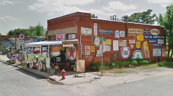
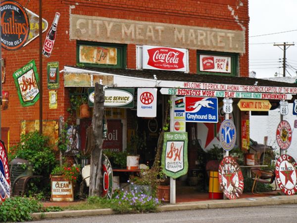
The former City Meat Market, now Sandhill Curiosity Shop
Index to this page
About Erick, Oklahoma
Facts, Trivia and useful information
Elevation: 2,064 ft (629 m). Population: 961 (2024).
Time zone: Central (CST): UTC minus 6 hours. Summer (DST) CDT (UTC-5).
Erick the second town in Oklahoma nearest the Texas state line, after Texola. It is located on old Route 66 in Beckham county.
This was open country with few trees and little rainfall, farmers were not keen on the area until it was opened to settlement and the railway arrived allowing produce to be shipped to distant markets (1902).
Prior to that the area south of the North Fork of the Red River had been claimed by Texas, until the U.S. Supreme Court ruled in 1896 that it was part of the Choctaw Nation in the Oklahoma Territory, where it became Greer County.
The post office opened in February 1900, and it was named DEnis, but it changed to Erick on November 16, 1901. The town was incorporated that same year.
Like most of the Route 66 towns in this part of Oklahoma, the town was developed by the Choctaw Townsite and Improvement Co., which purchased lots along the right of way of the Choctaw, Oklahoma and Gulf Railroad line (later the Chicago, Rock Island and Pacific Railway) which was being built westwards towards the Pacific.
Erick, the name
It was named after Beech Erick, the President of the Choctaw Townsite and Improvement Company, that laid down and developed the town of Erick.
The line reached the town in 1902 (in those days it was part of Greer County). At statehood in 1907, Erick became part of Beckham County.
It was initially a farming community producing cotton (it had cotton-gins) and cattle. Salt was extracted from the nearby salt springs. In 1926 Route 66 was aligned through the town at a time when oil was discovered causing a population boom (peaking at 2,231 residents in 1930).
The drought of the "Dust Bowl" caused farmers to fall on hard times with many residents migrating west to California. World War II saw traffic grow along Route 66 and motels and service stations sprung up to cater to the travelers' needs.
When local celebrity Roger Miller was asked by an interviewer what was Erick close to, Miller wryly replied "It's close to extinction"
At that time the local Chamber of Commerce printed a promotional brochure: "Erick is not a war spoiled town or just another boom town but a town with a half century of service".
Route 66 was bypassed by I-40 in the mid 1970s, causing loss of business to the town, as traffic moved to the freeway.
Where to Stay
Book your hotel near Erick
There are several hotels in nearby towns along Route 66
> > Book your Hotels in nearby Elk City or Sayre
Lodging Near Erick along Route 66
There are several hotels in the area close to this town. Alternatively you can also find your accommodation along Route 66 in the neighboring towns and cities. We list them below (listed from east to west):
On Route 66's Main alignment
Eastwards
Westwards
>> There is a RV campground close to Erick.
Erick’s Weather

Location of Erick on Route 66
This part of Oklahoma is a relatively dry region. The yearly rainfall is around 24.7 in (627 mm). Summers are hot but with lower temperature during the night which make them bearable.
May and June see most rain (4.1 and 3.7 in. - 104 and 94 mm).
The average high during summer is around 95.6°F (35.2°C) and in winter it is 50.7°F (10.4°C). The average low in summer is around 67.7°F (19.8°C) and in winter is 22.5°F (-5.3°C).
Snow: Snow falls in this region at any time between September and May (the first snowfall takes place usually, on the first week of December). Its altitude causes greater snowfall than locations further east: averaging 17” per year (with maximum values of about 40”) - 43 to 102 cm.
Tornado risk
Erick is located in Oklahoma's "Tornado Alley and experiences about 11 Tornado watches every year.
Tornado Risk: read more about Tornado Risk along Route66.
Map of Route 66 through Erick
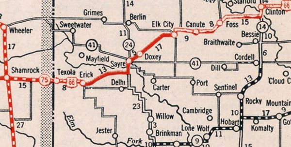
The map below was published in 1931, it shows the alignment of US66 between Clinton Oklahoma and Texas. Erick is on the left of the map. Only a part of the alignment was paved (solid red line), the rest was an "All-weather road" west of Erick, unpaved.
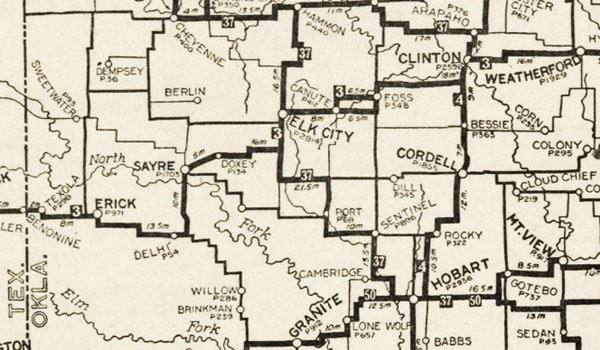
An earlier map, from 1924 -two years before Route 66 was created, shows the alignment of Route 66 through Erick
Our Map of Route 66 Map in Oklahoma shows all of the US-66 alignments in the state, and all the towns along it.
This map shows US 66's alignment in Erick
Route 66 Alignment near Erick
- Texola to Amarillo (next)
- Clinton to Texola (Erick's)
- Yukon to Clinton (previous)
Route 66 landmarks & attractions
Sights in Erick
Historic Context
In his "A Guide Book to Highway 66", published in 1946, Jack DeVere Rittenhouse tells us about the town in its Route 66 heyday:
ERICK. (Pop. 1,591; alt. 2,055'; Elms garage; cafes; gas; DeLuxe Court, also Erick Ct. and Trailer Park; stores.) US 66 crosses the one main street of the town, which is the first town you encounter, going west, which has any of the 'true' 'western' look, with its wide, sun-baked street, frequent horsemen, occasional sidewalk awnings, and similar touches Rittenhouse (1946)
Town Attractions
The first "Western town" on Route 66.
We will tour Erick from east to west.
Windmill Garden
As you approach Erick from the east, the highway curves and takes a east-west course. Just 1.5 miles ahead, to your right, you will see a collection of windmills, around twenty of them, jutting out of the ground, and behind them, dozens of old rusty vintage cars.
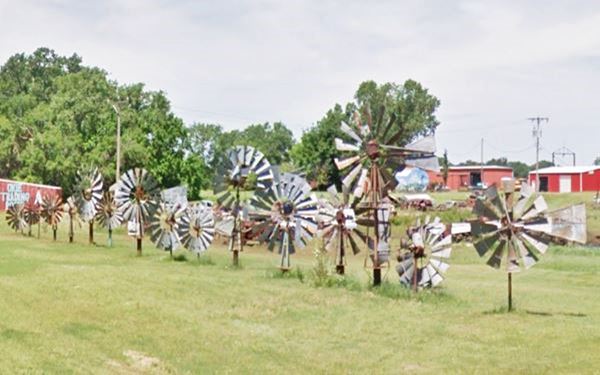

Welcome to Erick, Source
Click image for Street View
Welcome to Erick sign
Continue west, the four-lane divided highway converges into a wide street, to your left is the "Welcome to Erick" sign. This is the eastern side of the town.
Texague Style Texaco Gas Station
Ahead, to yor right are the remains of a Texaco gas station.
At 615 Roger Miller Blvd. The station is now the only Texaco in Erick, the other one, further west has been torn down.
Though it has lost its canopy, you can make out its modern, austere and clean design created in 1938 by Walter Teague for Texaco.
Below is a photo of the station when it still had its canopy.
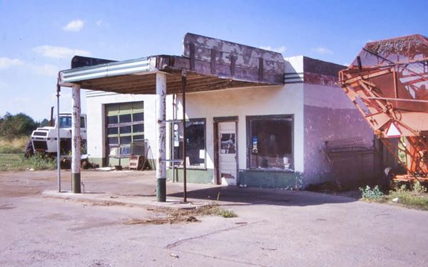
Click image for St. View
>> Learn all about the Teague-style Texaco service stations along Route 66
Vintage Gas Station
595 Roger Miller. Now Route 66 Motors, this old station, has a two bay garage with multiple glass panes on the doors. A red band across the top of the building and an office. A canopy protects the pumps area. oblong box design is from the 1940s, but we can't identify the brand.
Ahead, to your right (419 Roger Miller Blvd.) is another oblong box gas station (maybe a Phillips 66?), see its street view. It has a two bay garage, concrete pump islands, and lacks a canopy.
Neon sign of the Cabana Motel
The now razed Cabana Motel promoted itself as having "Ultra Modern Comfort". It was located to your left, by the fire department on Route 66 and Poplar St.
All that remains is the repurposed neon sign as you can see in the images below.

Old Motel neon sign. Source
Sheb Wooley and Route 66 (Roger Miller)
Drive west until you reach the main intersection in town, Route 66 and Sheb Wooley Ave. Below is a view, looking east along Route 66 from this junction, in the 1950s, and today.
The Town's Country Musicians
Two very popular Contry music performers lived in Erick: Sheb Wooley and Roger Miller. The town has named its two main throughfares after them.
Wooley was born in Erick in 1921 and was also a songwriter and an actor. Miller though born in Texas grew up in Erick.
Roger Miller (1936 - 1992)
Roger Dean Miller, Sr. Was an American songwriter, musician, singer and actor. His most recognized tunes included the chart-topping country-pop hits "King of the Road", "Dang Me" and "England Swings", all from the mid-1960s Nashville sound era. He acted in the Tony-award winning Broadway musical "Big River".
He was inducted into the Country Music Hall of Fame in 1995.
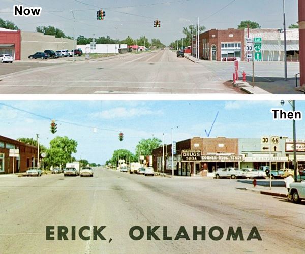
Click image for Street View
First National Bank
101 Sheb wooley Ave, Erick, OK. (SW corner of US 66 and Wooley).
Listed in the National Register of Historic Places.
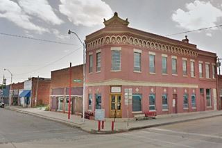
A historic building dating back to 1907 on the main corner of Erick, it houses the 100th Meridian Museum.
The two story red-brick building was erected in 1907 and served as the town's bank, it also had a barber shop. The top floor was used for office space. A bank operated here until 1968.
100th Meridian Museum
Corner of Roger Miller Blvd & Sheb Wooley Ave, Erick OK
A tribute to the 100th meridian, the border with Mexico first, and later with Texas, with exhibits on life along the meridian from prehistoric days till early day Erick.
Facing the Museum, on the SE corner, is another red brick building which used to be the "Roger Miller Museum", it closed for good. The building was built in 1929.
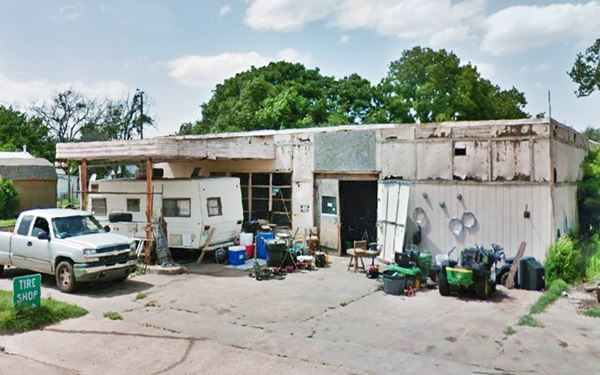
Sandhill Curiosity Shop
Head south along Sheb Wooley Ave. for one block, and to your right on the corner of W. 3rd St. is a classic Route 66 attraction, Erick's Sandhill Curiosity Shop.
Covered with old enamel signs, the fascia of its awning reads "Insanity at its Finest", "See Rednecks Work and Play in Their Own Environment", and "Welcome to Erick Oklahoma: the "Redneck Capitol (sic) of the World" Yee-Haw!".
Its Route 66 Roadside attraction sign tells us that it is "the oldest brick building in Erick. It is now the home of Harley and Annabelle, 'The Mediocre Music Makers'".
Return to Route 66, turn left and head west for 1 block. Ahead are two old gas stations, a Mobil, a Phillips 66, and a third one, now razed, which was al Texaco.
Site of the now gone Texaco station
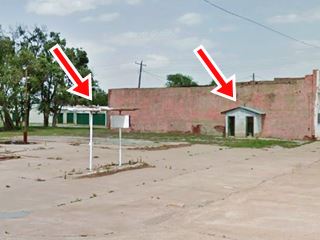
The magnificent 1930-40s Driggers Texaco station stood on the NE corner of Route 66 and N Walnut Ave. It was torn down, and all that remains (see the red arrows in the pictures) are the gas pumps and the outhouse. Below is a set of photos showing it before and after it was demolished.

The Texaco before it was razed.
Cottage Style Phillips 66
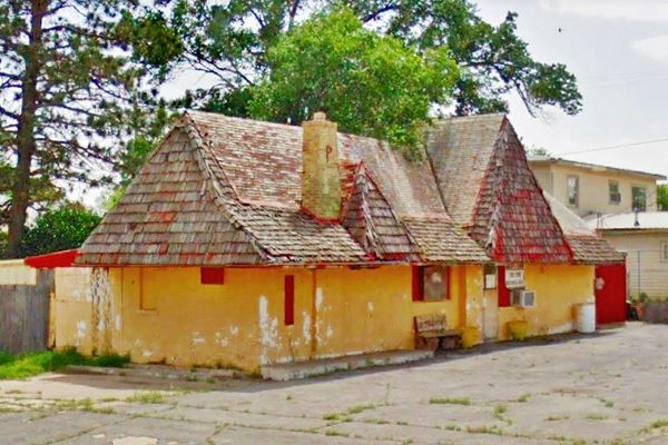
Facing the Texaco, on the SW corner of Route 66 and S Walnut Ave. is this hardly recognizable Phillips 66 station. The "Brandin Iron" Bar.
Phillips built these stations from the late 1920s into the late 1940s. In 1947, they changed the color theme, to a tan paint and orange roof. This building now has added extensions to the roof, with shingles. The chimney shows us it was a Phillips station, it has the "P" that identified these stations.
DeLuxe Court
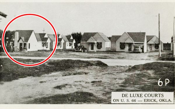
Surprisingly, the DeLuxe Court, an auto court or 1930s motel mentioned by Rittenhouse also had a Phillips 66 station, could it be the same one? This one seems to be larger as the original roof beyond the shingles shows. However, it may have been enlarged at a later date. Below is a vintage postcard of the DeLuxe Court, the Phillips 66 is marked with the red circle. We have not been able to find any reference to its address in Erick.
There is a third vintage gas station at this intersection, a Mobil.
Mobil gas station
On the NW corner. The old station is in pretty bad shape, but it can be identified as a Mobil because of its modern-style design: Flat roof, canopy flush with roofline and extending from the office. The canopy has rounded corners and narrow poles supporting it. Three red and white bands extend around the canopy and these were typical of Mobil (Magnolia) stations.
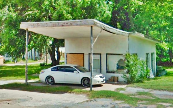
Continue west, on the second block, to your left is a non-descript vintage service station, it has an angled canopy and a very small office, no garage and a single pump island.
Erick "past and present", a vintage Route 66 Service Station shielding a modern car. Erick, Oklahoma
West Winds Motel
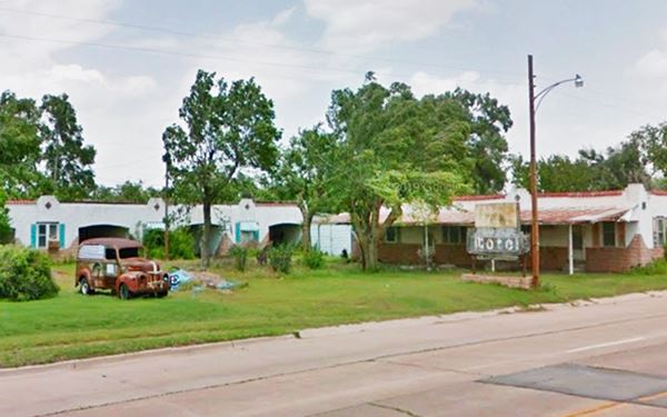
Drive 3 blocks west, to your right, you will see a historic motel.
W 623 Roger Miller Blvd, Erick, OK. (NW corner of W Wade and Choctaw Ave.)
Listed in the National Register of Historic Places.
The remains of a vintage late 1940s Route 66 Motel.
Built after World War II, it was five blocks west of the main junction in town. It was built in Mission Revival style with stucco walls and metal roof sheeting shaped like red tiles.
It has two buildings and once sported a flashing neon sign with the hotel name pained beneath a bucking horse. The sign is still there.
Both buildings were located at right angles (south and east) with the owners house located on the west side giving it a "U" shape. It was probably built by Ralph Fails or Floyd Pamplin sometime between 1946 and 1948, after Rittenhouse passed through Erick (he didn't mention it). The Pamplins operated it for many years.
The neon sign, still there, but rusty, displayed a painting of a bucking bronco.
There is a Ford panel truck (1946?) parked on the property. A "Panel Truck" is a small delivery truck with a closed body. It has no windows in the cargo area.
Doc West Garage
Across Route 66, on the SW corner of S Birch Ave. is a 1930s garage built in brick, with a wide doorway facing the side street.
Garages were common in the days when cars weren't as reliable as they are now. A trip along Route 66 would probably include a stop and some garage along the way.
Keep west, at Highland Drive to your left is a classic motel and to your right another vintage gas station.
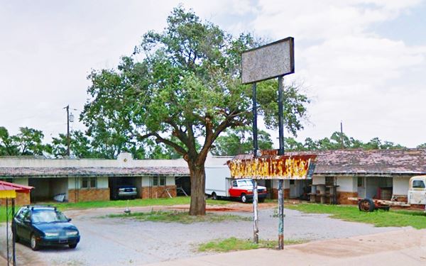
Elm Motel
823 W. Roger Miller Blvd. This motel was built in 1940 (perhaps the Erick Court mentioned by Rittenhouse), it has garages between the rooms and an L-shaped layout. The rusting sign still says "Reasonable Rates" on its bottom box.
Another vintage station
On the south side of Route 66 is another oblong box garage.
The well maintained white building has a two bay garage, and an office on its western side. There is no sign and the pumps island has been removed. It is a 1940s design, but the brand is unknown. It is pictured below.
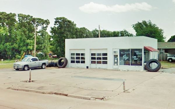
We are now reaching the western tip of Erick. Two more Route 66 landmarks: a motel and a Phillips 66 station from the 1950s.
Satellite Motel
To your left, after the gas station. This motel's postcard tells us that it had "TV, Refrigerated Air, Family Units, Room Phones, Wall to Wall Carpet, Tile Baths, Heated Swimming Pool" it was a Best Western.
The building is there, and the swimming pool too (red arrow). The neon sign has gone. Below a "Then and Now" view.

Satellite Motel postcard. Source


The station appears in a Satellite Motel postcard. Source
Gull Wing Phillips 66 station
Next to the motel, are the remains of a Phillips 66 gas station.
The image shows part of a Satellite Motel postcard and in it, you can see the gas station.
The slanted V-shaped canopy is typical of the Gull Wing stations built by Phillips 66 in the early 1960s.
In the street view (click image to see it) you can see that the office also had canted plate glass windows, which were also part of this modern "Googie" design. The canopy covered the pump island and you can make out the circular base of the pylon that supported its apex (red arrow).
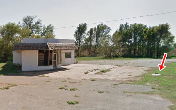
> > Read more about the Gull Wing stations along Route 66
This ends your city tour of Erick
National and State Parks
Black Kettle National Grassland
Located 42 miles northeast of of Erick (Map with directions).

Black Kettle National Grassland
OK-47 and OK-47A, Cheyenne, Oklahoma. he Grassland spans around 30,000 acres of rolling hills, wetlands and prairies cut by serveral rivers and streams. Ideal for hicking, horseback riding, wildlife viewing.
There are deer, turkey, geese, coyotes and bobcats. It also has three lakes which are used for swimming, fishing and watersports.
Free admission. More information (580) 497-2143.
Sandy Sanders Wildlife Area
13.7 mi. south of Erick (Map with directions).
Covers almost 30,000 acres of rolling land to the north of Elm Fork of the Red River.
A place for hiking, birdwatching and hunting. More information: (580) 471-3371.
Some sponsored content
>> Book your Hotel in Tulsa

Credits
Banner image: Hackberry General Store, Hackberry, Arizona by Perla Eichenblat
Linda D. Wilson, Erick. Encyclopedia of Oklahoma History and Culture, www.okhistory.org
Jack DeVere Rittenhouse, (1946). A Guide Book to Highway 66.


