US 66 on the Red River
Old 1958-1969 gas station on Route 66
Index to this page

TheRoute-66.com is reader-supported. When you buy through links on our site, we may earn an affiliate commission at no additional cost to you.
About Sayre, Oklahoma
Facts, Trivia and useful information
Elevation: 1,808 ft (551 m). Population: 4,375 (2010).
Time zone: Central (CST): UTC minus 6 hours. Summer (DST) CDT (UTC-5).
Sayre is the county seat of Beckham County, in western Oklahoma, roughly halfway between Oklahoma City, and Amarillo, Texas along Route 66 and I-40, its motto is: "Main Street On Historic Route (66)"
The Western part of Oklahoma has been inhabited for more than thousand years, however the first records date back to 1541 when Spanish explorer Francisco de Coronado passed through the region seeking for "Quivira", a mythical city of gold.
The U.S. government relocated to Oklahoma Native Amerian tribes from eastern US (from Ohio to Delaware to Florida) in the mid 1800s. Later natives from other parts west of the Mississippi River were moved to Reservations in the "Indian Territory", as Oklahoma was known in those days.
Vintage 1930s Postcard of Sayre
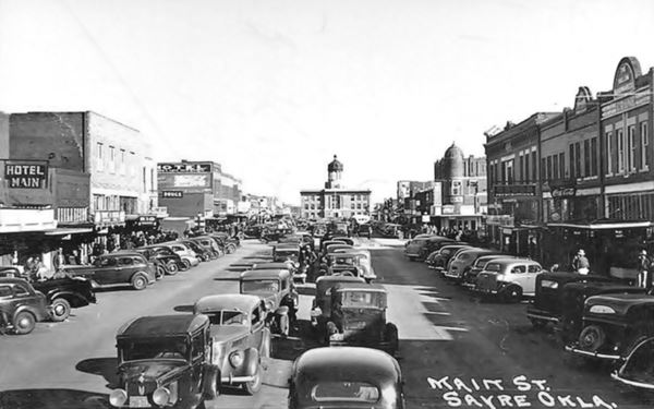
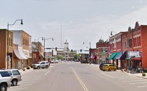
The same view nowadays, you can identify many buildings that appear in both photos.
Main Street Sayre nowadays
However, in the 1880s the government's policy changed. It decided that the natives had to be assimilated. This led to the dissolution of the Reservations. The individual tribe members were each given a plot of 160 acres and the government
purchased the rest of the land creating a vast surplus territory that was "opened" to settlement to non-natives.
The land around Sayre was settled in the 1892 Cherokee & Arapaho Opening, but as with most towns along Route 66 in this part of Oklahoma, the townsite was the outcome of the railway expansion westwards, into Texas, heading towards the Pacific.
There were some two hundred settlers in the area at the time that the Choctaw, Oklahoma and Gulf Railroad (later Chicago, Rock Island and Pacific Railway) laid its tracks through it in 1901. The Choctaw Town Site and Improvement Company platted a town at a suitable site and sold lots to new settlers. The town was incorporated on 14 September 1901 and grew quickly.
The Name: Sayre
The town was named after Robert Heysham Sayre, of Pennsylvania the chief engineer and a stockholder of the railroad. The surname Sayre reached England during the Norman conquest in 1066 AD, and was the place of residence of the family in St. Saire, Normandy. It may derive from the trade name (assayer of metals) or share its root with Sawyer (woodcutter).
The town was located on the north side of the North Fork of the Red River. Initially it was part of Roger Mills County, but in 1907 a new county was created by taking
the southern portion of Roger Mills and the northern part of Greer County. Beckham county was formed and Sayre became the county seat in 1908 after defeating Erick.
It was a farming community that also processed cotton in its cotton gins. Oil was discovered in the 1920s and strenghthened the economy. When Oklahoma Highway No. 3 was incorporated into US Route 66 in 1926 and aligned through Sayre, a steady flow of travelers passed through town, linking its Main Street
to Route 66.
The Grapes of Wrath in Sayre
John Steinbeck wrote the Pulitzer Prize-winning novel "The Grapes of Wrath" in 1939, and the following year John Ford directed a movie based on it, and won an oscar as best director. In this work, Steinbeck tells the tragic journey of a group of evicted farmers during the Great Depression and the Dustbowl, as they moved from their midwest farm to California seeking a better life.
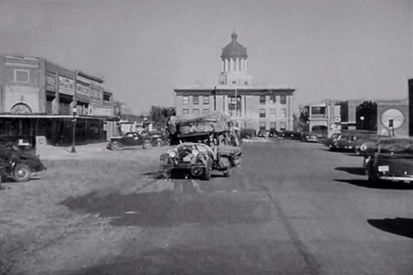
The family drove down Route 66 to reach California. There is a scene in the movie that used Sayre's Beckham County Courthouse as a backdrop, it is shown below, a mix of poverty, despair, hope and the stern County building looking down on them.
Read More at our Grapes of Wrath page.
Where to Stay. Accommodation in Sayre
Book your hotel at Sayre, there are several hotels in Sayre
> > Book your Hotel in Sayre
Lodging Near Sayre along Route 66
There are several hotels in the area close to this town. Alternatively you can also find your accommodation along Route 66 in the neighboring towns and cities. We list them below (listed from east to west):
On Route 66's Main alignment
Eastwards
Westwards
>> There are RV campgrounds in Sayre.
The weather in Sayre

Location of Sayre on Route 66
Western Oklahoma is a dry region. During summer it is warm and slightly wetter while winter is cool and dry, with occasional snow storms
Temperature: average high in summer (Jul) is 92.7°F (33.7°C) and the low is 68.1°F (20°C) . During winter (Jan), the average high 46.7° (8.2°C) is and the low is below freezing: 22.1°F (-5.5°C). Rainfall is 28.7 inches per year (729 mm), reflecting the drier conditions of this part of Oklahoma.
Snow does fall in the area and it can be encountered between September and May (the first snow usually falls on the first week of December). Its altitude causes greater snowfall than locations further east: averaging 11” per year (with maximum values of about 40”) 27 to 102 cm.
Tornado risk
Sayre is located in Oklahoma's "Tornado Alley and experiences about 11 Tornado watches every year. Tornado Risk: read more about Tornado Risk along Route66.
Map of Route 66 through Sayre
Route 66 was created in 1926, and was unpaved during its first years. It followed a longer and irregular alignement at first. The map below, from 1924 shows the alignment that would be followed by Route 66 between Elk City and Sayre through Doxey, and from Sayre to Erick via Delhi.
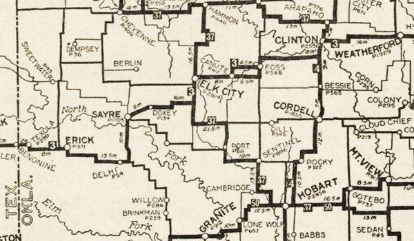
In 1929 it was paved and realigned, following a shorter and straighter course. The map below, published in 1931, shows the alignment of US66 between Clinton Oklahoma and Texas. Saure is on the left side of the map. Part of US 66 was paved (solid red line) at that time. West of Erick, it was an unpaved "All-weather road".
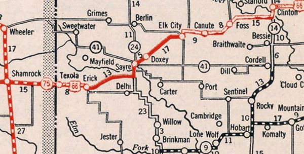
Visit our Map of Route 66 Map in Oklahoma page. The map shows all the Route 66 alignments across Oklahoma as well as the towns and cities along it. See this map showing US 66's alignment in Sayre (it is the classic alignment). Route 66 followed different alignments through the city, we describe them further down.
Route 66 Alignment near Sayre
- Texola to Amarillo (next)
- Clinton to Texola (Sayre's)
- Yukon to Clinton (previous)
Route 66 landmarks & attractions
Sights in Sayre
Sayre's Rloute 66 sights
We will do our "City Tour" driving from East to West along the 1929-58 alignment into the city. Starting at the North Frontage Road, by Exit 25, we will head into Sayre. After 1 mile you will reach a classic motel and the site of a gas station.
Stardust Motel
To your right is the motel, built in the 1950s. Its postcard tells us the following "Stardust Motel and Restaurant. "Sayre's Newest And Finest Motor Hotel" All units have room phones. TV. tub and shower, electric heat, carpeting, and air conditioning. Enjoy home cooked meals and steaks in our fine restaurant Family rooms and connecting units - John Shattuck. Owner.
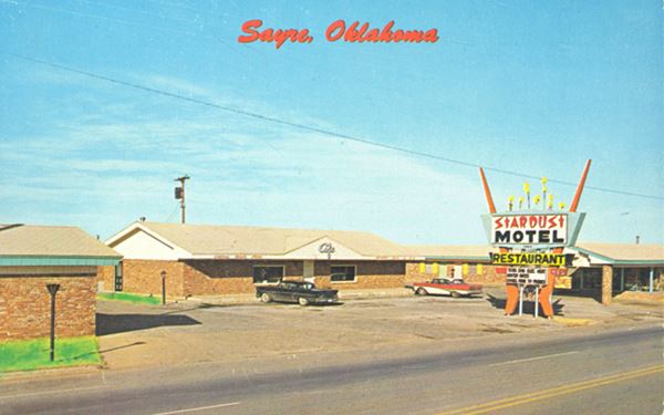
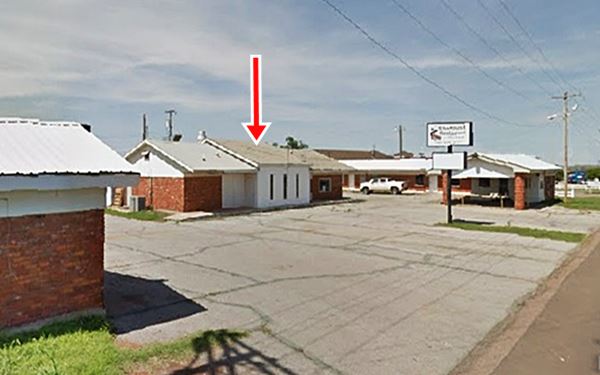
The amazing neon sign has been replaced, what a loss! And the central building's roof has changed (red arrow), but the rest remains the same.
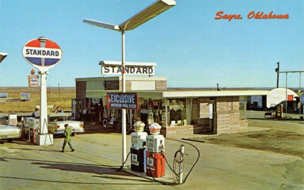
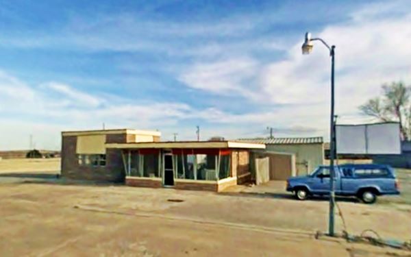
Spence & Russell Standard Station
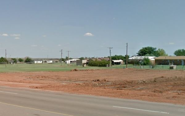
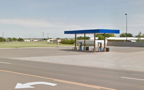
Across the road, was the Spence and Russell gas station. The postcard pictured below, had the following text printed the back of the card: "Spence & Russell Standard Station 'Friendly Service Since 1949' Known from Coast to Coast for quality products and guaranteed service. Full line of Atlas tires, batteries, and accessories. Western souvenirs and curios. Decals of all 50 states. Tourist supplies, maps, and highway information. Clean Rost Rooms Open 24 hours Phone WA 8-2370 East Highway 66 Sayre, Oklahoma".
It was located on the south side of Route 66 northeast of Sayre between Wade and N. Watts St. It was still there in 2008, but the building was demolished in 2013 to make way for "progress", another icon of Route 66 gone forever.
Time goes by in Sayre, Route 66 fades away...Spence & Russell Standard Station, then and now
Drive west to see a classic motel and its great neon sign.
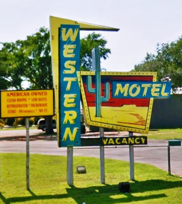
Western Motel and Neon Sign
0.2 mi. west, at 315 N E Hwy 66, Sayre.
Still open, the motel's late early 1960s postcard tells us it was "The newest and most modern motel in Sayre. Refrigerated air conditioning - Family Units - Vented Heat - Wall To Wall Carpets - Combination Tub & Shower - Tile Baths - Storm Shelter - 25 Units - Telephones - Playground. Ollie & Ruby Elliott, Owners & Managers."
The motel hasn't changed and its neon sign is intact as you can see below.
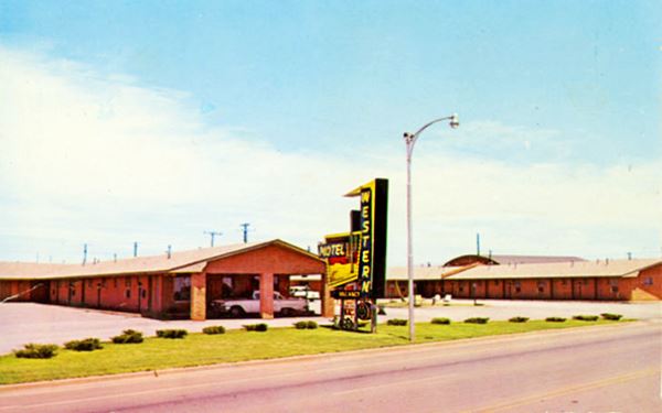
The motel's Neon Sign has survived and is in excellent conditions:

Sayre 66 Lounge Mural
To your left, with a mural on its eastern wall. Pictured below.

Mural at Sayre Lounge. Source. Click for St. View
1940s Sinclair gas station
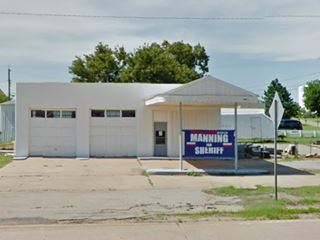
NE corner of Route 66 and Central Dr. This 1940-50s former Sinclair service station had a modern oblong box design with detached V-shaped canopy. It has two garages, with multi-light windows on its doors. The office has a single door and large Large plate glass windows. It is pictured above.
1940s Mobil Station
Across Central Dr. at 199 NE Hwy 66 is another old station, this one was a Mobil.
You can make out the flat canopy, with curved tips, and ridge-grove design, typical of Mobil stations. It has two garages with glazed service bay doors. A later add-on is the gabled roof over the flat canopy, see its picture below.
Old Garage
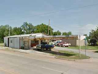
Tignor's Garage is located across Route 66 from the Mobil station. On a triangular shaped block. It is likely that it wasn't a gas station because there aren't any pump islands under the long canopy. It is an old building, pictured above.
El Paso-Dixie station
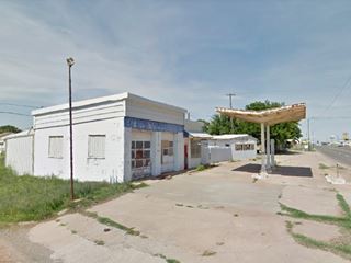
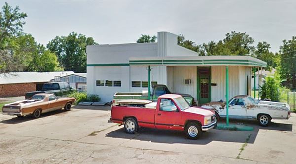
Ahead, Route 66 takes a curve and heads south. On the curve, to your right is a former El Paso-Dixie station. It has a modern box-like shape, with a canopy that extends out, flat, from the roof of the office which is lower than the service bays. The canopy has slender metal poles and square corners.
In 1958, El Paso Natural Gas Products Co. and the Dixie Oil and Gas Company merged and they sold gasoline under the El Paso-Dixie brand name. Their gas stations had the distinct feature of a vertical pier that extended above the roof displaying their logo on both sides. See its picture at the top of the page.
1926-28 US 66 Alignment
Two blocks ahead, when you cross Benton Ave., you meet the original alignment of US66 coming from the Elk City. It used Benton to enter Sayre between 1926 and 1928, when it moved to the alignment now followed by I-40 and NE Route 66 into Sayre.
Pedestrian Underpass
Drive south for 0.6 miles to N 4th St. and E Elm St., here is a tunnel built by the New Deal Works Progress Administration (WPA) as part of a job creation project during the Great Depression.
Built in 1939, it is 75 feet long (23 m) and runs east to west under Route 66, providing a safe crossing for pedestrians -imagine the heavy traffic along US 66 in those days.
Now it has been equipped with tornado resistant steel doors and a sign next to it indicates "Severe Weather Shelter Area". It has a WPA plaque inside the entrance. There is another pedestrian tunnel under Route 66 in Chelsea, OK.
Downtown Sayre
Drive five blocks south to the downtown area. To your left on E Poplar St., before crossing the railway tracks is the local Museum and Depot.
Sayre Rock Island Depot and Museum
Listed in the National Register of Historic Places
106 E Poplar. This was the Sayre Rock Island Depot, built in 1927 which now houses the local Museum. It is a brick and stucco Italian Renaissance Revival building. The railroad gave it to the town in 1972 when passenger service ended. Today it houses the museum.
Shortgrass Country Museum
Open since 1992. Artifacts, photographs and replicas of early the life in the shortgrass prairie during the early years.
Sayre Downtown Historic District
Route 66 alignment splits
The 1926 to 1958 alignment of US66 turns right along West Main Street. Later, from 1958 to 1970, it continued south along South 4th St.
Main and 4th Streets, Sayre, OK
Listed in the National Register of Historic Places
The heart of Sayre, the community's business center, with over 30 historic buildings erected between 1903 and 1952. There are many red-brick faced buildings with flat tops along Route 66.
The image depicts the Bank of Sayre, 102 W Main. The building has the year 1905 written on its parapet, and is now a City building.
Owl Drug Store
4th and Main St. NW corner. The Pharmacy and Soda fountain has the longest antique soda fountain in Oklahoma. It operated from 1901 to 1992.
It is on the north side of Main St, facing the Bank.
Beckham County Courthouse
Listed in the National Register of Historic Places
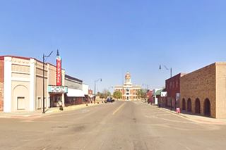
To your left, looking east along Main Street. The building, finished in 1911 is topped by a large dome, the three-story Neoclassical building has stood for over one century as the center of Sayre's civic life. It was built in brick and stone and 12 Doric columns support the dome.
Drive east towards the Courthouse, and on the second block, to your left is a classic movie theatre.
Stovall Theatre
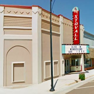
210 E. Main Street. The 800-seat Stovall Theatre opened in June 1950. After closing for good, it was purchased by the Main Street Program in 2005 and restored to its former glory. Below is a "Then and Now" set of photos.

Photo of Stovall Theatre in 1951 Source
Return to Main and 4th St. turn left one block to see three Route 66 sights.
Easter gas station and Motel
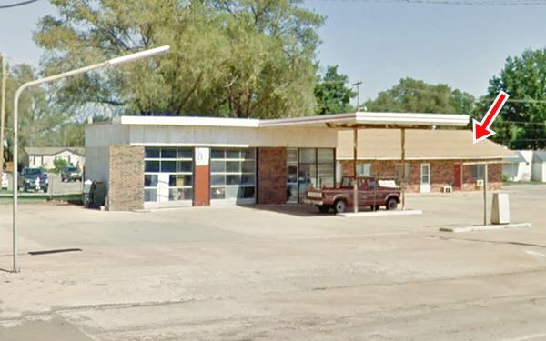
On the NE corner of S 4th St. and E. Walnut (116 S. 4t). Thomas Elvern Easter (1924-2014) purchased the Easter's Service Station and Easter's Motel in Sayre in 1971. The station closed in the late 1990s, but he ran the motel until his death. It was a Mobil station that had belonged to the Wingets. The image below shows the gas station and behind it (red arrow) the motel.
Phillips 66
Across E Walnut St. on the SE corner is a former Phillips 66 gas staton. It has the typical "Rock Frame" design from the early 1950s. This design had large plate-glass windows that were canted (or slanted) like you can see in this station. It also used a curtain wall system combining glass and concrete blocks that were faced with rocks (hence its name "rock frame") like this station has. The canted windows reduced the glare of car headlamps and increased the visibility and indoor light. On the corner is the tall steel column that held the Phillips 66 shield.
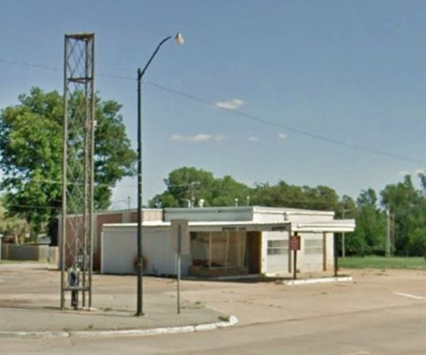
The 1958-1970 alignment continues south along S 4th St. and crosses the North Fork of the Red River, but there are no more "66 sights" along that segment. Turn around and head back to Main St. turn left and go west along the 1926-58 alignment.
Trivia: The Red River boundary controversy
The North Branch of the Red River runs half a mile south of Main Street. The border between Texas and the territories north of it was set at the Red River, but it has several forks. Texas claimed that the north fork was the boundary and the US government, and later the Territory of Oklahoma, said it was the South Fork. The United States Supreme Court ruled in 1894, that the boundary ran along the Red river's southern branch.
The 1926-1958 Alignment
Champin Service Station
Listed in the National Register of Historic Places
126 W Main St. A 1934 Route 66 service station on Sayre's Main Street. Built to serve locals and Route 66 travelers.
It is a one story building with concrete walls and large windows with a streamlined Art Moderne design, popular at the time.
The Prince Brothers built the first service station and sold it to the Champlin Refining Co. in 1928. They operated it until I-40 drew customers away from the city four decades later.
Conoco Station
On the NW corner of W Main and 6th St. (301 W main) is a remodelled former Conoco service station according to the Oklahoma Route 66 Resources Survey of 2002.
It has solid box pillars supporting the flat roofed canopy, a single bay garage to the right, and the office to the left, the canopy extends from the office. It is pictured above.
Half way up the block, is a historic hotel.
Old Boggs Hotel
311 W Main St. The hotel was built in 1910 and after 1926 it served the needs of Route 66 travelers for many years.
It needs repairs. It marks the western edge of the Historic District.
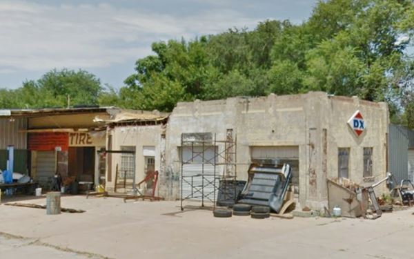
Sinclair ⁄ DX
On the next corner is a former Sinclair ⁄ DX gas station. From the 1930s.
The decoration of the garage has a Mission or Spanish Eclectic stylistic influence.
It has suffered some alterations on the western side of the building where the office is.
The "Y" and curve on US66 west of Sayre
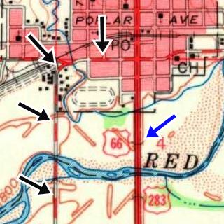
See the 1960 USGS map of Sayre (click image for large sized map). The Black arrows mark the 1926-58 alignment. The Blue arrow shows the alignment after 1958. Notice the curve at the "Y" fork (upper left corner black arrow), where US66 turns sharply southwards
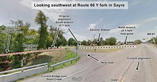
The road originally had a sharp 90° curve where OK-152 continued with a western course, crossing the railroad, and Route 66 turned south. Later a "Y" fork was built here, both highways split at the fork with US66 heading in a curve towards the south.
The remains of the old road can be seen. The original fork has been abandoned and linked to the present W Main St. on the western side of Short Creek.
Ahead there is a 90° turn next to the railroad.
Click on the thumbnail for a full size view of the fork today. This is the Street View.
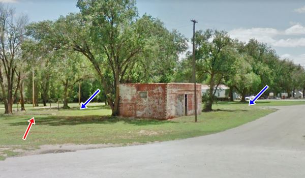
Savmor Station
Inside the Y-fork, facing both the extant south branch (blue arrow) and the eliminated north one, and with its back to S 9th St. (current US66) which wraps round it (90° turn).
It is a red-brick building with no other markers. You can make out the concrete pump islands and some rusting steel poles jutting out of them (red arrow).
Route 66 alignment north of the N. Fork of the Red River
The 1926-58 alignment continues south towards the North Fork of the Red River, where it is cut off: the bridge has gone. See this map with directions.
Route 66 alignment south of the N. Fork of the Red River
You can drive on the south side of the river, see this map with directions of the 1929-1958 alignment.
1926-29 Alignment
The first (1926-29) alignment continued south along BK-21 now cut by I-40. See these two maps: map north of I-40 and map south of I-40 all the way to Erick. This one wasn't paved while it was US66.
1958-70 alignment
Continues south from downtown Sayre along S 4th St., and as it curves to meet I-40, the eastbound lanes of the original alignment are now buried under the westbound lanes of the freeway. The westbound lanes of US66 now are part of the N. Frontage Rd. See this map with directions.
On the south side of the North Fork of the Red River you can visit the Historic Sayre City Park. Accessible from both old (1928-58) and new (1958-70) Route 66 alignments.
Sayre City Park
I-40 and BK-Q (NW corner of W Wade and Choctaw Ave.)
Listed in the National Register of Historic Places
The park was built by WPA (Works Progress Administration - a Federal employment plan) in 1940-41. It had campsite, gazebo and a Pueblo-Revival style bathhouse with a swimming pool. It even had a mini-golf, pump house, tennis courts and, for those traveling along Route 66: camping facilities, fire pits and picnic tables for those willing to stop, rest or spend the night. See its Street View.
This ends your city tour of Sayre. Head west to visit Erick.
National and State Parks
Black Kettle National Grassland

Black Kettle National Grassland
OK-47 and OK-47A, Cheyenne, Oklahoma (see Map and Directions)
The Grassland is located 30 miles north of Sayre and covers about 30,000 acres of rolling hills, wetlands and prairies cut by serveral rivers and streams. Ideal for hicking, horseback riding, wildlife viewing. There are deer, turkey, geese, coyotes and bobcats. Three lakes are used for swimmng, fishing and watersports. Free admission.
History
It was the home of the Comanche Indinas who hunted and camped in the area. The area was a Cheyenne and Arapaho Reservation in 1867, and the following year Lt. Col. A. Custer attacked a Cheyenne village ("Battle of Washita") killing the chief Black Kettle (1803-1868) and more than 100 Native Americans. It was later opened to White settlers in 1892 and after the drought of the 1930s (Dust Bowl) it was bought back by the government for restoration and designated a national grassland in 1960.
Some sponsored content
>> Book your Hotel in Tulsa

Credits
Banner image: Hackberry General Store, Hackberry, Arizona by Perla Eichenblat
Jack DeVere Rittenhouse, (1946). A Guide Book to Highway 66.
Linda D. Wilson, "Sayre". Encyclopedia of Oklahoma History and Culture, www.okhistory.org
ODOT Route 66 maps
Sayre Oklahoma Historical Society


