Index to this page
Historic Route 66 Clinton to Texola
Oklahoma Route 66 Itinerary and maps
Each leg of Route 66 described below has an interactive map and many image maps so you can follow the alignments of the highway along the way:
- KS-OK state line to Vinita - map of this segment
- Vinita to Tulsa - Map of this segment
- Tulsa to Chandler - Map of this segment
- Chandler to Yukon - Map of this segment
- Yukon to Clinton - Map of this segment
- Clinton to Texola - Map of this segment
Texas, next leg
Kansas, previous leg
Background on Historic Route 66
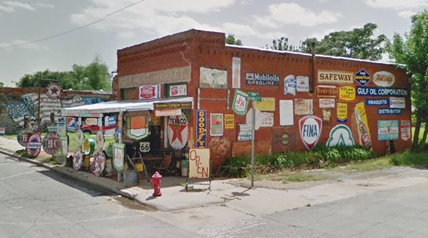
The former City Meat Market, now Sandhill Curiosity Shop
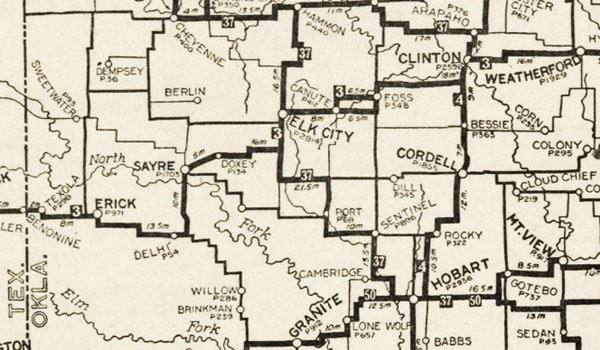
Route 66 was aligned along existing roads, all of them unpaved. Below is a map published in 1924 -two years before Route 66 was created. It shows the roads that existed a that time. Route 66 followed the alignment from Clinton to Texola, through Foss, Elk City, Sayre and Erick.
It was long, had many 90° turns as it followed the "section line roads" that marked the lines used by surveyors to map the counties and towns. Farmers used them as roads, and the main ones became the first highways.
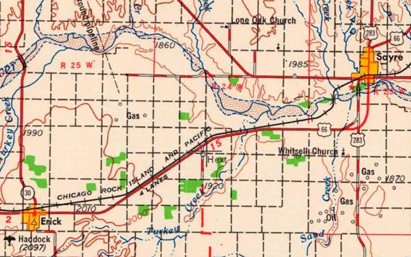
This first alignment was straightened out, shortened, and paving began in 1931. Below is a map published that year; it shows the alignment of US66 between Clinton Oklahoma and Texas. Only a part of the alignment was paved (solid red line), the rest was an "All-weather road" west of Erick, unpaved.
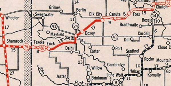
This alignment would be improved, and the highway was expanded to a four-lane "expressway" in the late 1950s. Finally I-40 would replace it in the late 1970s.
Route 66 in Clinton
Neon sign of Glancy Motel, Clinton, Oklahoma
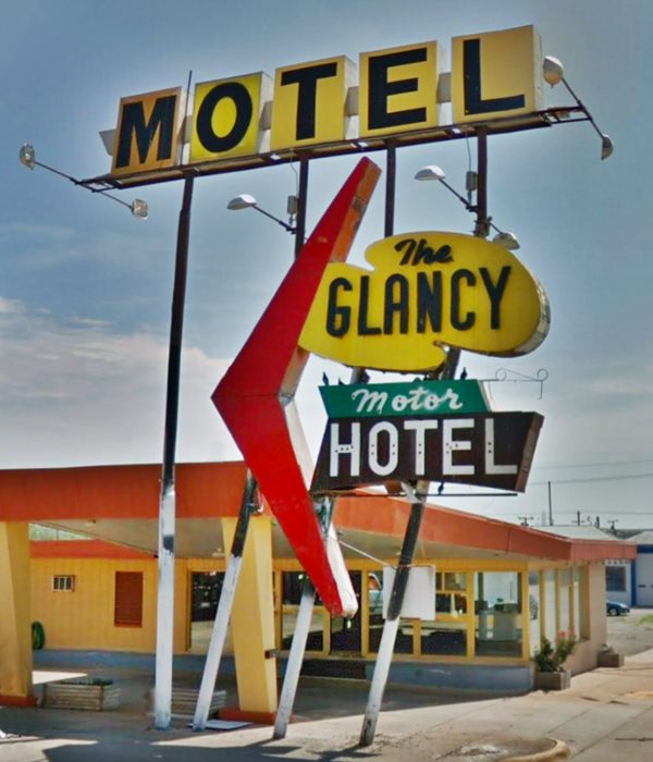
We will begin our journey on the eastern side of the town of Clinton, Oklahoma.
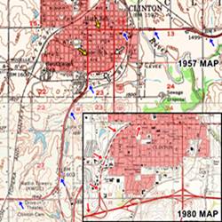
Click on the thumbnail image to see the different alignments of Route 66 through Clinton. Our custom interactive map shows all of them too.
1926 Alignment
>> red line in our custom map is the 1926 alignment across Clinton
The blue arrows in the image map show the eastern tip of the 1926 alignment it remained in use till 1985.
This first US 66 (1926) followed Gary, 4th St, Frisco and then south along 10th St.
Realigned in 1935
In 1935 it followed Gary and then 10th. southwards cutting two right angle turns off the alignment
>> pink line in our custom map is the 1935 realignment
1941 Separate traffic flows
After 1941 and until 1959 it took two separate alignments across Clinton, they can be seen in the 1957 USGS image map. Notice how at that time Gary Blvd. didn't curve around the western side of the city. It was built later.
1. White arrows. Eastbound traffic, along 4th St. and Opal St. (map)
>> blue line in our custom map is the 1941-59 eastbound traffic alignment
2. Yellow arrows. Westbound traffic, along 10th St.
1959 Alignment around Clinton
In 1959, a four lane freeway was built east of Clinton towards Weatherford and at what is now I-40's exit 69, it linked with the old alignment into Clinton. At the same time, Gary Blvd. was extended parallel to the railroad along western Clinton to what is now exit 65 (red arrows in image map). Here it continued west as a four-lane freeway (now I-40).
The freeway continued east to Exit 65A, linking with the 10th St. alignment. The current I-40 that loops around the SE side of Clinton didn't open until 1970. Route 66 was decertified in 1985.
>> yellow line in our custom map is US66 along Gary (after 1959)
South from Clinton
The original road south of Clinton continued along Neptune southwards from modern I-40 and then headed west after a curve along W. Commerce Rd. This segment was paved in concrete in 1931. It met what is now the modern I-40's alignment at Exit 62, and ran west from there along the S. Frontage Rd.
>> green line in our custom map is the 1926-59 US 66 South and West of Clinton

US 66 cut by I-40 at Exit 57
Route 66 runs as the South Frontage Road from Exit 62 westwards until a point just west of N 1280 Rd. by what is now Exit 57 it had a curve arching north as you can see in this 1955 aerial picture, now cut by I-40, then it forked, the 1926-31 alignment went west, the 1931-56 went southwest:
>> Alignments at Exit 57 in our custom map are color coded as follows:
Green: western tip with curve and fork. Teal: 1926-31 alignment into Foss. Navy blue: 1931-56 alignment south of Foss
1926-1931 road into Foss and westwards
This road was not paved, it was the old Postal Road. It headed straight west along a now missing section at the eastern tip of E1060 Rd; you can reach the existing segment via North frontage Road of I-40 and then take a right along N 2160 Rd. to E1060 Rd, where you should turn left. Keep west until reaching OK-44 and then head south towards Foss.
Go through the town along Broadway and keep straight until reaching modern OK-66.
The alignment continues towards Canute with a zig-zag alignment: Head south cross I-40 and keep south until reaching SW 1095 (turn right), then left on N2130 Rd. then turn right on E 1100 Rd. and follow it until you reach I-40 by Turkey Creek. The old road kept west along the north side of I-40 but now freeway cuts its path at S US 66 by Turkey Creek.
It is here that its path joins the one followed by the 1931-1956 alignment.
Old Kobels Place Service Station in Foss, slowly falling apart.
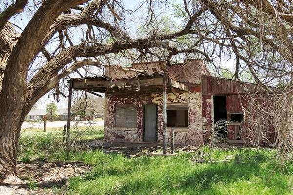
1931-1958 US 66 in Foss
When the road was paved in Portland concrete in 1931 it was straightened eliminating the sharp 90° turns and it bypassed Foss completely. From modern Exit 57, it ran along the current north frontage Road passing south of Foss. At Exit 50 it curved further south than the current alignment and is cut by I-44, here it merged with the 1926-1931 aligment and ran west (now along the north side of I-40, that cuts it here). See the blueline in our custom map at this point.
After 1958
Upgraded to a 4 lane road, it laid down the path followed later by I-40.
Lake Clinton and Canute Segment
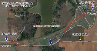
As mentioned above, Route 66 is cut after Exit 50 by Lake Clinton and I-40. Click on the map to enlarge it; the yellow arrow shows the 1926-31 alignment. The blue arrows mark the 1931-1956 and 57 alignments. These are now cut by I-40, which was built in 1956-57 in this area. The red lines mark the missing roadbed of Route 66, disrupted and cut off by I-40.
Through Canute
West of this point US 66 runs west on the north side of the Freeway towards Canute.
>> red line in our custom map is 1926-70 US 66 east of Canute
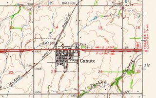
The old alignment is cut again by I-40 on the eastern side of Canute it is once again cut by I-40 which curves around the north side of the town, this bypass opened in 1970. The original 1926 to 1970 Route 66 kept on with a straight westerly course.
Route 66 runs through across the town located on the south side of I-40 for almost 2 miles. And at its western tip, the two lane highway forks, with the original alignment (1926-50s) on the north side -westbound lanes), now it is a local traffic road because through traffic takes the southern fork, which originally was the eastbound 1950s-70 Route 66.
Half Curbs
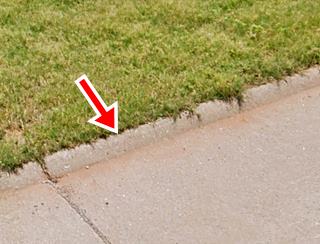
Drive along the old alignment and check out the "half-curbs" built when the road was paved in 1931; they were an experiment designed to keep the traffic from wandering off the paved roadbed onto the shoulder and prevent accidents. In fact they did the opposite. There are similar half curbs on Route 66 in Rolla MO also paved in 1931.
The old roadway merges into the later lanes ahead. It used to carry on straight, but now it is cut by I-40, it ends in a dead end.
The original US66 continues as the North Frontage Road on the western side of the cut-off.
Below is a view looking west along the westbound lanes, the original 1926-50s alignment. The red arrows show the half curbs on each side of the roadway. The blue arrow marks the newer (1950s) eastbound lanes into Canute.

West of Canute towards Elk City
>> yellow line in our custom map is the 1926-85 US66 into Elk City
This is a 3 mile-long segment, paved with the original 1931 portland cement which is only cut at the overpass of N2050 Rd. This was a two lane road between 1926 and 1956. The whole segment ends at the Super 8 motel at the entrance of Elk City.
In 1956 the highway was improved and became a four-lane expressway and this road became the westbound lanes of the new freeway until 1958. After that Route 66 moved to what is now I-40 and the old road became what it is now, a service road.
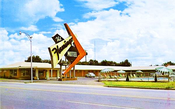
The 1926 to 1985 Route 66 enters Elk City west of Exit 41, itt originally ran along the westbound lanes. Later the eastbound ones were added. This was paved in 1931-32 with concrete. Ahead it curved south along Van Buren Ave. and then west along 3rd St. The bridge at Elk Creek was built in 1929 and at Washington St. the 1926 to 1929 alignment split south to follow a zig-zag alignment with right angle turns all the way to Sayre. In 1929 the highway was realigned westwards. Below we describe both alignments:
1926-28 alignment from Elk City to Sayre
>> green line in our custom map is the 1926-28 Elk City to Sayre alignment
It ran south along Washington St., west along 7th St., and again south along Randall St. Now it is cut after crossing West Elk Creek, by the lake. It continues on the south side of the lake and then runs with a general westwards direction until it is cut by a creek. Drive round to pass the creek and start at OK-34 and E1170 Rd. Go west. After going through Doxey a small long gone railway depot and community (green marker in custom map is Doxey).
Now you must cross the railroad, turn south along BK24, cross the tracks again and head west along BKW (later BKO) passing I-40 and entering Sayre along Benton Ave.
1929-85 Elk City to Sayre
The alignment in 1929 was shortened, it continued west and after leaving the city, along the modern westbound lanes of OK-66 that curved with a SW course.
>> red line in our custom map is 1929-85 Elk City US66 westwards
After meeting I-40 at Exit 32 it continued as the North Frontage Rd. with a NE to SW course. The highway used this alignment from 1929 to 1956, when it moved to I-40 west of Exit 32 into Sayre.
>> violet line in our custom map is 1929-56 US66 into Sayre
Timber Creek Bridge
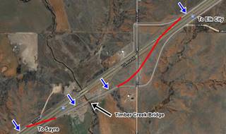
At the present overpass at N1910 Rd. (see custom map) the highway originally curved south to cross Timber Creek, and this part is now cut by I-40; the original alignment continues on the south side of the freeway and crosses the creek using a historic 1928 steel truss bridge. Then it swung back (now under I-40) returning to its course along what is now the N. Frontage Road.
Old 1928 Timber Creek Bridge on Route 66 near Sayre, Oklahoma
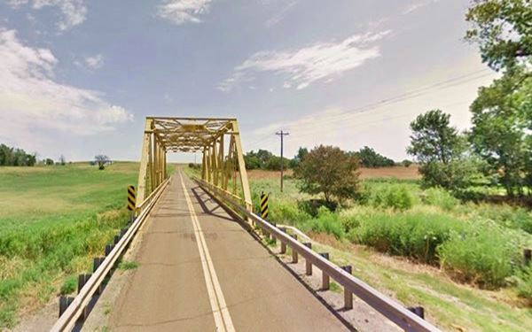
From 1956 to 1966 this roadway became the westbound lanes of the four-lane US66. After 1966 it became the Frontage road of I-40 ⁄ US66.
Route 66 across Sayre
Historic US66 (violet line in custom map) continued along the North service Rd up to Exit 25 where it enters Sayre.
Route 66 then turned south along N 4th St. It met the 1926-28 alignment at Benton Ave (green line in custom map) and continued to downtown Sayre (turquoise line in custom map) to Main Street, where the alignments forked over the years at Main and 4th Street.
>> Alignments into Sayre in our custom map
1926-58 US 66 West of Sayre
>> bordeaux line in our custom map is 1926-58 US66 west of Sayre
The "Y" and curve on US66 west of downtown Sayre
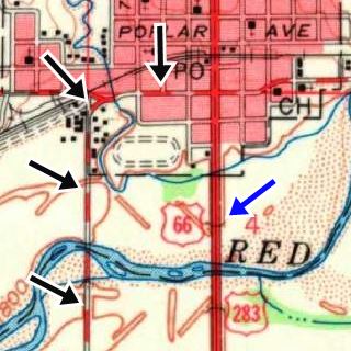
See the 1960 USGS map of Sayre (click image for large sized map): The Black arrows mark the 1926-58 alignment. The Blue arrow shows the alignment after 1958. Notice the curve at the "Y" fork (upper left corner black arrow), where US66 turns sharply southwards
The road originally had a sharp 90° curve where OK-152 continued westwards after crossing the railroad. Here Route 66 turned south. Later a "Y" fork was built here and US66 heading in south with a soft curve. The remains of the old road's curve can stil be seen.
The 1926-58 alignment continues south towards the North Fork of the Red River for 1⁄4 mile, where it is cut off: the bridge has gone. But you can drive to the south side of the river where the roadway reappears 1⁄2 mile south of the river, see this map with directions of the 1929-1958 alignment south of the river.
1926-29 Alignment in Sayre
The first (1926-29) alignment continued south along BK-21 now cut by I-40.
>> gray line in our custom map is 1926-29 US 66 in Sayre
On the south side of the freeway the 1926-29 Route 66 took a zig-zag course all the way to Erick. This one wasn't paved while it was US66. Further down we describe this 1926-29 Alignment into Erick
>> yellow line in our custom map is the 1926-29 US66 into Erick
1958-85 alignment in Sayre
The later wider and straighter alignment used from 1958 to 1985 continues south from downtown Sayre along S 4th St., and as it curves to meet I-40, the eastbound lanes of the original alignment are now buried under the westbound lanes of the freeway. The westbound lanes of US66 now are part of the N. Frontage Rd.
>> green line in our custom map is 1958-70 Sayre alignment
Sayre to Hext
The map shows a four-lane Route 66 (USGS 1955). Current I-40 was built later, and runs south of US 66. Click on the map to see a large size map.
The original two-lane Route 66 west of Sayre all the way to Hext and beyond, up to Erick, was upgraded to four lanes in 1956. Later, in 1975 when I-40 opened, its westbound lanes were built on top of the two eastbound lanes of US66, leaving only the two former westbound lanes which now make up the North Frontage Road.
>> purple line in our custom map is the Sayre to Hext alignment
Further ahead where the railroad and US66 converge and I-40 curves to the SW, the old four-lane alignment has survived. Though the 2 westbound lanes cannot be driven, and are partly covered by bushes and trees that have grown on it since 1970, and can still be seen and walked. We marked the eastern and western tip of this roadbed with purple markers in our custom map:
>> purple markers in our custom map are the west and east tips of the surviving roadbed.
The image shows the current and old lanes as they cross Turkey Creek.
Current two lanes and the two old westbound lanes of US66 in Hext
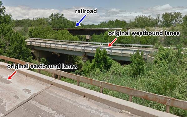
These westbound lanes run on the north side, and parallel to the remaining lanes that are still open to traffic. They end just east of I-40s Exit 11, where the road becomes a real four-lane highway (the original four-lane Route 66). Then the higheay crosses the freeway and continues like that all the way into Erick.
Abandoned lanes of Route 66 in Hext, Oklahoma
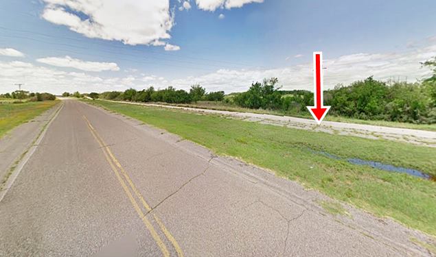
The now abandoned and closed westbound lanes of the 1956-1970 four-lane Route 66 in Hext
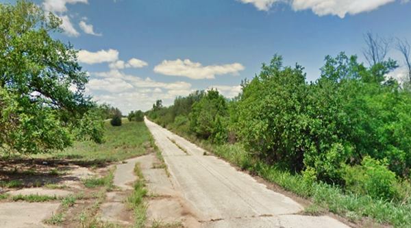
I-40 was built south of Hext in 1975. The four lane Route 66 begins again just north of Exit 11 and runs west towards Erick.
Hext to Erick
From Exit 11, US 66 1929 - 1975 alignment becomes a four-lane highway (the second set of lanes was built in 1956) all the way to Erick
>> pale blue line in our custom map is 1929-75 Hext to Erick US66
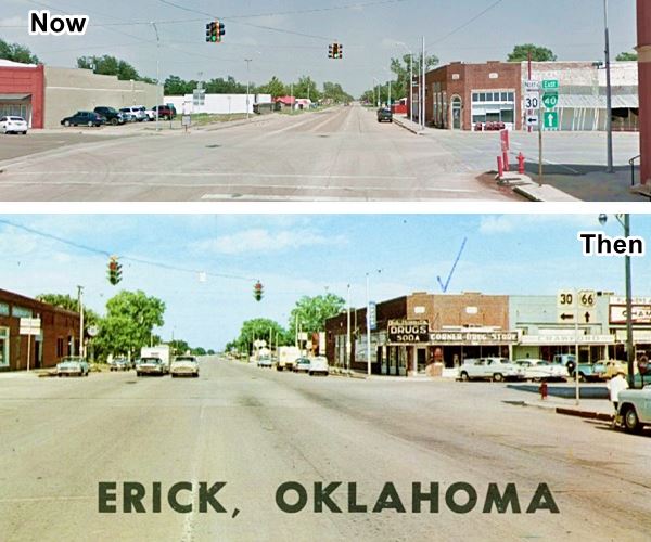
Click image for Street View
1926-29 Alignment into Erick
>> yellow line in our custom map is the 1926-29 US66 into Erick
The original unpaved Rute 66 ran along another alignment, from Sayre, it came through the community of Delhi (map with directions).
It didn't enter Erick it ran along the south side of the town. On the SE side of town at 12th St. and South Sheb Wooley you can see the remains of an ancient gas station on the original '66.
Old Gas station in Erick, on 1926-28 Route 66
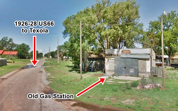
The road passed just south of downtown Erick, and continued west to Texola. This alignment met the later one paved in 1931, just 2.2 miles west of Texola.
At this crossroads, on the SW corner of US 66 and N 1680 Rd. you can see the remains (ruins) of Crossman's Camp, a camping area and primitive motel and gas station.
>> pink line in our custom map is the 1926-29 US66 Erick to Texola
Final leg of this segment and Oklahoma
Historic Route 66 alignment Erick to Texola
After 1929 alignment left Erick along W 3rd St. and continued with a straight course towards Texola. It became a four-lane highway in 1956.
>> pale blue line in our custom map is Erick to Texola alignment after 1929
Original segment of the 1929 roadway
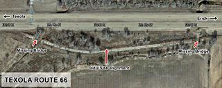
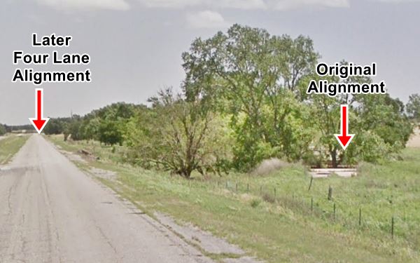
You can spot a small section of the original two lane road to your left, on the south side of the eastbound lane at Little Turkey Creek, 2.8 miles east of Texola.
>> orange line in our custom map is the 1931 roadbed at Little Turkey Creek
The old road runs with a curved alignment between two culverts on the Creek, one at each tip of the segment. The culverts are gone and the road cannot be driven. See this map showing its location.
State Line and End of the Journey
The highway ran through the town of Texola, curved to the NW and 0.4 mi ahead reached the Texas - Oklahoma state line, marking the end of this leg of your Route 66 Road Trip from Clinton to Texola.
Next Section
Route 66's alignments from Texola to Amarillo
Previous Section
Route 66's alignments from Yukon to Clinton

Some sponsored content
> > Book your Hotel in Sayre

Credits
Banner image: Hackberry General Store, Hackberry, California by Perla Eichenblat
Jack DeVere Rittenhouse, (1946). A Guide Book to Highway 66
Route 66 Maps. Oklahoma D.O.T.


