Site of Cotton Boll and Washita motels
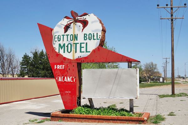
Cotton Boll Motel neon sign
Index to this page
About Canute, Oklahoma
Facts, Trivia and useful information
Elevation: 1,896 ft (578 m). Population: 541 (2010).
Time zone: Central (CST): UTC minus 6 hours. Summer (DST) CDT (UTC-5).
Canute is a town on Route 66 in the nortwestern part of Washita county, Oklahoma.
Classic Washita Motel

Spanish explorer Coronado passed through this part of Oklahoma in 1541 seeking for the mythical Eldorado (city of Gold). Later Mexican and Spanish miners sought gold in the rivers and it is said that the Fabled gold-mining town of Cascorillo was located on Turkey Creek.
Oklahoma was the land where the U.S. government relocated Native Americans after forcibly removing them from their original homelands east of the Mississippi or, as with the Cheyenne and the Arapaho, from their territory west of that river.
The natives were granted land in Reservations in the Indian Territories. Canute now stands on land once granted to the Cheyenne and Arapaho people.
Cheyenne & Arapaho
The Cheyenne originally lived near the Great Lakes in Minnesota and in the 1700s moved to the Great Plains in the 1700s. The Arapaho lived in Montana, Wyoming, South Dakota and Canada. Both tribes met in the plains and formed an alliance with a territory that extended from Texas to Montana.
Successive treaties with the US led them to be relocated to what is now Oklahoma.
Cheyenne Arapaho Opening
In the 1880s, the US government changed its policy and decided to assimilate the natives. It gave each tribe member 160 acres of land and bought back the surplus Reservation land. It set this land apart for settlement by Europeans and non-native Americans.
3.5 million acres of land were opened for settlement by the U.S. government on April 19, 1892. The settlers rushed to the Oklahoma Territory for their homestead in the former Arapaho-Cheyenne Reservation.
Canute Service Station, Historic Site.

By the end of the "opening", almost 80% of the land remained unclaimed, and by 1892 only 7,600 people had settled there.
The first settlers in the Canute area were homesteaders that arrived during the Cheyenne and Arapaho "opening" of 1892. The first community in the area was located about four miles northwest of the current townsite. It was named Keen, after the owner of the local general store (Robert Keene). He later moved his business to Oak, which was one mile north of modern Canute.
In 1898, the St. Francis of Assisi Catholic Church was established and dedicated in 1901. It was located 3 miles to the southeast of what is now Canute.
The Name: Canute
The town was named after "Cnut the Great" (c. 985 - 1035), King of England (1016 - 1035), of Denmark, Norway, and part of Sweden. He is commonly known as Canute. He was a Viking, and his succession led in 1066 to the conquest of anglo Saxon Britain by the Normans.
Keene moved again, this time to the site of Canute in 1899 and that same year a post office was created.
In 1902, when the Choctaw, Oklahoma and Gulf Railroad -which later became the Chicago, Rock Island and Pacific Railway extended its tracks westwards towards Texas, the Great Southwest Townsite Company surveyed the land and held a lottery for town lots; Canute had been founded.
The town grew to have a bank, newspapers, hotels, cotton gins and many stores. The population reached 366 in 1930.
The first oil well in Western Oklahoma was drilled in Canute in 1917 and it was the deepest well in the world at the time.
Route 66 was aligned through the town in 1926, in those days it followed Oklahoma State Highway No. 3. The road was later paved and soon travelers were stopping at the local motels and service stations bringing prosperity to this small rural town.

Getting to Canute
Heading east from Canute down Route 66 are the towns of: Foss (7 mi.), Clinton (21 mi.), Weatherford (37 mi.) and even further, Oklahoma City (110 mi.)
To the west, is Elk City (6 mi.), Sayre (24 mi.) and Erick (40 mi.) and even further, in Texas is the town of: Shamrock (63 mi.).
Accommodation: Where to Stay in Canute
Book your hotel near Canute. There are several motels and hotels in nearby towns along Route 66
> > Book your Hotel in Elk City
More Lodging Near Canute along Route 66
There are several hotels in the area close to this town. Alternatively you can also find your accommodation along Route 66 in the neighboring towns and cities. We list them below (listed from east to west):
On Route 66's Main alignment
Eastwards
Westwards
> > There are RV campgrounds in Elk City.
Canute’s Weather

Location of Canute on Route 66
Average Summer (Jul) temperature: low 68.9°F (20.5°C); high 94.8°F (34.9°C) . Average Winter (Jan) temperature: low 23.6°F (-4.7°C) and high 48.9°F (9.4°C).
As you head west in Oklahoma rainfall decreases: the average yearly rainfall is 26.9 inches (683 mm), with most rain falling during May, June and Sept. (4.6, 3.9 and 3.3 inches - 117, 99 and 84 mm respectively). Least rainy month is January (0.7 in. - 18 mm).
Snow falls in this region at any time between September and May (the first snowfall takes place usually, during the first week of December). There is more snow here than in the eastern parts of the state: more than 10 inches (25 cm).
An ice storm in 2002 cut power lines causing a 5 day power outage.
Tornado risk
Canute is located in the "Tornado Alley and experiences around 11 Tornado watches every year.
Tornado Risk: read more about Tornado Risk along Route66.
Map of Route 66 through Canute
The "Auto Trails" map below, printed two years before Route 66 was created in 1926, show Highway #3, or "Postal Highway" running along two alternate alignments from Foss to Canute, and then straight into Elk City. Route 66 was aligned along these earlier highways.
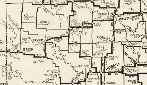
In 1926 it was a dirt road, but it was paved with Portland cement in 1931. It ran along what is now the North Frontage Road. Now it is cut by I-40 as it arches to the north to bypass the town. On the western side of the freeway US 66 ran into Canute along the westbound lanes of Historic Route 66. The eastbound lanes were added in 1957.
The highway crossed the town with an East-West course, passed beneath the railroad, that crossed the highway on a tressle built in 1931, and headed west along what now are the westbound lanes. Once again, it is cut off by I-40, that swings back after bypassing Canute. On the western side of the freeway, US66 continued along the North Frontage Rd. I-40 bypassed the town in 1970.
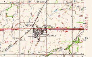
The thumbnail image of a USGS map (click map to see large size version) shows Route 66 crossing Canute in 1961.
See this Map of US66 through Canute.
Our Map of Route 66 Map in Oklahoma shows all of the US-66 alignments in the state, and all the towns along it.
Route 66 Alignment near Canute
- Texola to Amarillo (next)
- Clinton to Texola (Canute's)
- Yukon to Clinton (previous)
Route 66 landmarks & attractions
Sights in Canute
Historic Context
After driving Route 66 from Chicago to Los Angeles in 1946, Jack DeVere Rittenhouse wrote "A Guide Book to Highway 66". In it he described Canute.
Canute (Pop. 374; alt. 1910'; gas; Mahl Bros. garage; 1 trailer court but no cabins). Rittenhouse (1946)
He mentioned the "unusual bronze statuary" at the Cemetery and the cotton gins along the highway in town and the deeply red soil of the area.
Canute, a Classic Route 66 Town: its Attractions
We will tour Canute from east to west, starting at the point where the westbound and eastbound lanes split, on the eastern side of town. Just 0.3 miles ahead, to your left are the historic markers, and to your right, the cemetery and grotto.

Canute Cemetery Crucifixion Group, Source
Canute Cemetery
You can drive (with due respect for those who rest there) to the Grotto and Crucifixion bronze sculptures mentioned by Rittenhouse.
The Bronze Cucifixion group and Grotto were commissioned by the parishioners of the local Holy Family Church of Canute in 1928. It has a life-size depiction of Christ on the cross and the Virgin Mary with Mary Magdalen.
The Grotto is a monument to honor the pioneers and settlers of Western Oklahoma. The stone used to build it was brought from Red River, and the red granite is from Granite, Oklahoma, 40 miles away.
Im 1954 the State of Oklahoma declared it as a Tourist Attraction. See a Street View.
Canute's Stone Markers
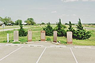
There are five red stone markers, and one white column across from the Cemetery, in the median area between west and eastbound lanes. You can park here.
These markers tell the stories of St. Francis Church, David Lee Walters, History of Canute, the Canute Centennial, and The Great Western Trail.
- St. Francis of Assisi Church. It was the first outpost of Catholicism in Western Oklahoma. Founded by Father Steber in 1899 three miles to the southeast of modern Canute. The marker also mentions the Groto and Crucifixion in the Cemetery.
- David Lee Walters. He was Oklahoma's 24th Governor (1991-95), and was born in Canute in 1951.
- Canute Town and County Centennial. Covers the history of Canute with a timeline and a description of the main events over the hundred years since it was founded (1902-2002).
- Canute Marker. With the town's history form the days of the Indians onwards.
- Great Western Cattle Trail. A red granite marker and a white trail "GWCT" pole. The trail was used between 1876 and 1895 when settlement impeded its use, to move 7 million longhorn cattle from Texas to Dodge City for shipment to the eastern US markets. The Trail crossed US66 and I-40 1.5 mi east of where Canute is now located.
First State Park
Adjacent to the Cemetery, on its western side (to your right) is the "First State Park in Oklahoma" to be built on Route 66 by the Works Progress Administration (WPA) in 1936. WPA's goals were to employ local labor, which was idle due to the Great Depression. Today it is a City Park.
Hoy Family Church
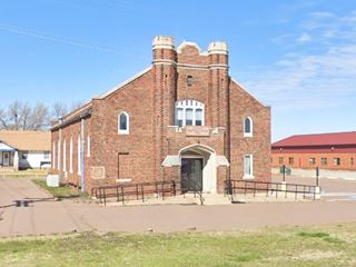
On the next corner, NW one, at N 2080Rd (9th St.) and Route 66. This red-brick building faces east, and has a plaque above its entrance that reads "Canute Heritage Center 1994". It was established in 1926 with Father P.P. Schaeffer as its first pastor. It closed in 1970 and now is private property. Renamed in 1994 as the "Heritage Center".
Unusual artistic Bridge
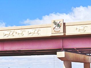
If you head north, 1⁄4 mile to the freeway, the N 2080 Overpass at I-40's Exit 47 has some unusual artistic touches.
The bridge was recently restored and repaired and the external face of the parapets that line de deck was embellished with galloping horses carved into the concrete and the decorative medallion of the Oklahoma state flag.
Trivia. Oldest Bank
Head back to Route 66 and go west, to your left, on the SW corner of the second block, at 7th and Route 66 you will see a stone building. This is the Oldest Bank in Oklahoma.
The Canute Bank is the oldest state chartered bank still in operation. It was chartered in 1902 as the First State Bank of Canute. In 2021 the Citizen Potawatomi Nation acquired it.
Cotton Boll Motel
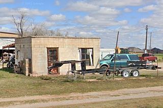
Ahead, to your right, half way down the block is the former "Cotton Boll Motel" now a private property, with its fantastic vintage neon sign.
The back of the postcard shown below reads: "COTTON BOLL MOTEL On Highway 66 Canute, Okla. 16 Units Completely New & Modern Wall to Wall Carpets - Tile Baths Free TV in Rooms - Refrigerated Air-Conditioning - Baby Cribs - Laundry Service for Customers at Motel. Mr. & Mrs. Woodrow Penick Owners & Managers." it was postmarked in 1960.
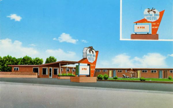
The slanted roof of the canopy is unchanged (red arrow), and also the units, on the north side of the property. Fortunately the neon sign has survived (for now).
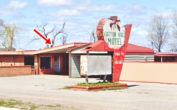
Viola and Woodrow had been cotton farmers. They named their motel after their former occupation. It opened in 1960 and closed in 1979 after I-40 bypassed the town.
Lion statue and rotating temperature "Clock"
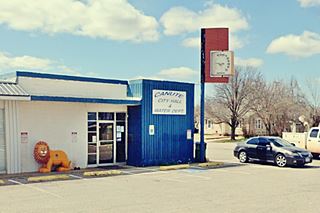
Across the street, on the SE corner with 6th St. is the City Hall & Water Dept. with a Temperature "Clock" on the corner (the "lion" is from the Lions club next door).
Snowder Station
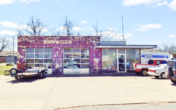
Head west, to your left, on the SE corner of Main St. and Old Route 66 you will see a classic 1950s gas station.
It has a double service bay with multiple glass panes on its eastern side, and an office with plate glass windows to the west. It has a "stepped" design: The office's flat roof is lower than the service area roof, and wide eaves on the office. This was a style favored by Conoco in the 1950s. It lacks a canopy and has no gas pumps. The word "Snowder" is painted across its facade.
Canute Service Station
Across the street you will see the Historic Canute Service Station, on the SW corner of Main St. and Route 66, Canute, OK.
Listed in the National Register of Historic Places
This is a vintage 1936-39 service station with an unusual "Pueblo Deco Design."
The Canute Service Station was built along the lines of a local Pueblo Deco style (popular along Route 66 in the Southwestern states). It is a one-story building with stuccoed walls. The concrete block building has gabled roof concealed behind a stuccoed belt that covers the front of the building. The canopy and main building's corners have castellations with triangular pediments decorated with red tiles and diamond shaped inserts.
Canute Service Station seen from the east.

The service station was built in two stages (1936 and 1939). The 1936 part on the west, was initially a dance hall but local businessman Clarence Kelly added the gas station in 1939 on the eastern side and altered the original western wing to match the new building's style. It also had three service bays facing Main St.
It fixed punctured tires, repaired engines and offered other services to motorists. Today it is a reminder of the inspiring architecture of the old days along Route 66.

Canute Jail
Source. Click on image for St. view
Canute Jail
Behind Canute gas station, on the alley to its right (western side) halfway down the block southwards from Route 66.
The building is not visible from Route 66. It is a solid Jailhouse built in 1918. With bars on the windows.
Kupka's Texaco Service Station
105 Old US Highway 66, Canute, Oklahoma. Ahead, to your right, across Route 66 ia another classic gas station.
This gas station used to sell Sinclair and Texaco gasoline. The locals know it as "Kupka's Service Station". Now it is abandoned.
Kupka Service Station

It has a canopy over the service bay that blends into the roof of the office and garages. The style is the 1930s Streamline Moderne design, with curved canopy corners and the metal facing that contours the base of the roof and canopy.
It has some features created by Walter Teague in the mid-1930s for Texaco, like the two parallel, rounded forms that project across the canopy from back to front (a rounded front was added to them on this building, on the tip of the canopy). It also has three Texaco green bands around the building, canopy, and above the display and service bay doors.
It is hard to imagine the cars lining up to fill their tanks along a bustling Route 66 in the bygone days before the Interstate was built.
>> Learn all about the Teague-style Texaco service stations along Route 66
Another old filling station
Head west. To your right on the NE corner of Route 66 and 1st St. is a small block shaped building with a single entrance and window.
No service bays, and a single concrete pump island overgrown with grass.
Across the highway, to your left is the other Canute motel, the "Washita".
Washita Motel

Canute Washita Motel Neon sign. Click for St. view, Source. Click for St. view
This motel has a classic neon sign. Located on the SE corner of 1st St. and Route 66.
Named after the county, which in turn was named for the Ouachita Native Americans. The name comes from the French trappers, who transliterated a word used by the Caddo people, that means "good hunting grounds".
The building has an L-shaped layout and 8 units. It's most outstanding feature is the neon sign, slowly flaking and fading away, but outstanding as a classic Route 66 attraction.
We have read but haven't found proof, that the Washita was once located in Foss, and in the 1960s moved to Canute.
Leaving Canute
Ahead is the tressle underpass built in 1931 to avoid a grade crossing with the railroad, followed by a more rural setting. There seems to be another gas station (?) to the left (street view) with an odly angled roof.
After passing it, the two lane highway forks, with the original alignment (1926-50s) on the north side -westbound lanes), now it is a local traffic road because through traffic takes the southern fork, which originally was the eastbound 1950s-70 Route 66.
Half Curbs
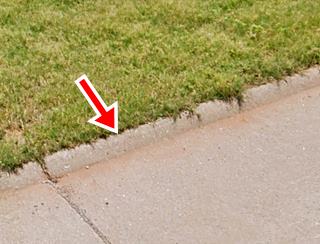
Drive along the old alignment and check out the "half-curbs" built when the road was paved in 1931; they were an experiment designed to keep the traffic from wandering off the paved roadbed onto the shoulder and prevent accidents. In fact they did the opposite. There are similar half curbs on Route 66 in Rolla MO also paved in 1931.
The old road merges into the later lanes ahead. It used to carry on straight, but now it is cut by I-40, it ends in a dead end.
The original US66 continues as the North Frontage Road on the western side of the cut-off.
Below is a view looking west along the westbound lanes, the original 1926-50s alignment. The red arrows show the half curbs on each side of the roadway. The blue arrow marks the newer (1950s) eastbound lanes into Canute.

This is the end of your Canute City tour along Route 66, continue your road trip westwards, into Elk City
Some sponsored content
>> Book your Hotel in Tulsa

Credits
Banner image: Hackberry General Store, Hackberry, Arizona by Perla Eichenblat
Historic Place registration, Canute Service Station NPS
Jack DeVere Rittenhouse, (1946). A Guide Book to Highway 66.


