Route 66 in Bagdad CA
Index to this page
About Bagdad U.S.A.
Facts, Trivia and useful information: Ghost Town
Elevation 787 ft (188 m). Population 0 (2025).
Time zone changes when you cross the California - Arizona state line. Time zone: Pacific (MST): UTC minus 8 hours. Summer (DST) PDT (UTC-7).
Bagdad is a ghost town on Route 66, west of Amboy and east of Ludlow, in central-western San Bernardino County, southeastern California.
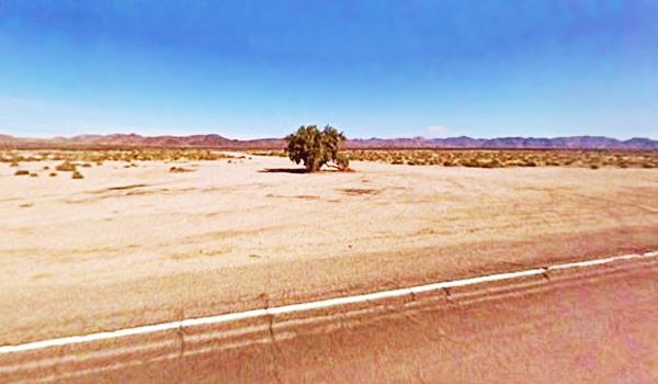
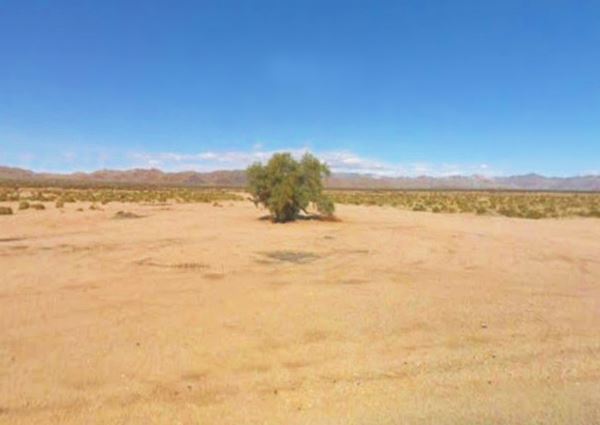
Only a tree marks the site of Bagdad. View from Route 66
The History of Bagdad, California
Visit our Barstow web page to learn more about the early history of this area.
The main wagon trail into California used in the late 1800s crossed the Mojave to the north of what is now Bagdad, along the Mojave Trail.
Railroad in Bagdad
However the railways were approaching: the Atlantic & Pacific Railroad or A & P (In 1897 it was absorbed by the Atchison Topeka and Santa Fe Railroad) reached Needles, California 1882, after crossing New Mexico and Arizona.
In the meantime, a rival railroad, the Huntington and the Southern Pacific (SP) laid a line eastwards from Barstow to Needles to block any advance of their competitors, the A & P into California. So an interchange was built at Needles, CA linking both lines as a cargo transfer point between them.
But the A&P decided to reach Los Angeles on its own, directly, and started to build a line parallel to the tracks of SP. This forced SP to negotiate the sale of their Mojave line to A&P in Oct. 1884. In 1885 A&P linked its Barstow - Needles Branch via Cajon Pass to San Bernardino and Los Angeles, reaching the Pacific coast.
The Railroad built a stop in this part of the Mojave desert and named it Bagdad. It was a coaling and watering place for the steam locomotives which had to replenish water quite frequently. Fresh water was brought in using 20 tank cars every day from Newberry Springs as the water in Bagdad's wells was briny.
West of Amboy, the railroad rose gradually out of a Basin where, a former now dry lake bed. The highest point on the railroad was west of Bagdad at Ash Hill, the divide at 1,944 feet. The whole area is volcanic, with plenty of lava flows and cinder cones.
The Name, Bagdad
The station was named after the ancient city of Baghdad in Iraq, founded in 762 AD by Abu Jafar al-Mansur a city with over 9,000,000 inhabitants the second largest city in the Arab world.
The Californian town's name dropped the "h", because the correct spelling is "Baghdad" the name comes from Middle Persian "bag-dat" meaning: "Given by God".
The ghost town got its name because of its setting in the Mojave desert.
The post office opened in 1889 and two roads were built to link it with the gold mine at Orange Blossom and the silver and lead mines to the south. The ore was shipped out by railcars.
The 1900s saw Bagdad grow into a village with a Harvey House hotel for those traveling by rail located at the railroad depot, and a post office. There were many SF Railroad buildings too as you can see in the picture taken in 1943, notice the palm trees.

1943 view of Bagdad depot by Jack Delano. Source. Click to enlarge
The station and the palms are no longer there.
National Old Trails Highway
In the early 1910s when the National Old Trails Highway (N.O.T.) was built for automobiles, from Barstow to Needles, and it followed the railroad, passing through Bagdad.
The Automobile Club of Southern California (ACSC) map of 1912 shows Bagdad, but it is merely marked as a station 7 miles west of Amboy followed by "numerous cross washes" until Siberia (that nowadays is also a Ghost Town) located 8 miles futher west. The road continued in a winding course through "Very Heavy Sand" past Klondike which was not on the road, and Ash Hill, also, to the north of the highway. It reached Ludlow and crossed the SF RR to its north side, after 21 miles.
The 1913 Arizona Good Roads Association map of 1913 shows "many cross washes and gutters" between Amboy and Bagdad, where there was a water tank at the station. Even more cross gutters and light sand to Siberia followed by "Heavy sandwash" to Ash Hill "summit".
Three years later, the ACSC map infomed that Bagdad had no services and a sandy wash preceded its arrival to the area near Klondike station.
A fire burned down most of the town in 1918 and the town never recovered. The 1922 the ASCS map showed Bagdad as lying north of the road and offering "Meals - Gas - Oil. "The post office closed in 1923.
US 66 is created in 1926
By the late 1920s, mines had become exhausted, but traffic along Route 66 grew so 1,000 ft. south of the former station, a small community grew to cater to the tourists. A motel opened as well as a truck stop.
After Route 66 was created and aligned along the N.O.T. road, it was straightened out, widened, and the bridges were improved. It was also paved.
By 1934, the ACSC map showed Bagdad as clustered on both sides of the railroad, and two roads reaching the station from the North to Orange Blossom Mine, and South into Lead Mountains. A constant flow of travelers during the years following WWII kept the community going.
But this prosperity came to an end when I-40 opened in 1973, bypassing Route 66 between Ludlow and Needles. Bagdad declined and died.
Now all the buildings have been razed, and only the rubble or foundations remain, and one solitary tree.

Where to Stay near Bagdad
There is nothing in Bagdad but you can find your lodging nearby in Barstow or Needles:
> > Book your Hotel in Needles or Barstow
More Lodging Near Bagdad along Route 66
Below you will find a list of some of the towns along Route 66 east and west of Bagdad; click on any of the links to find your accommodation in these towns (shown from east to west):
You are so close to Las Vegas and the Grand Canyon!
>> Check out RV campground near Bagdad
The weather in Bagdad
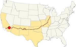
Location of Bagdad on Route 66
The ghost town named Bagdad is located in the Mojave Desert and has a "Subtropical desert climate" with very dry and hot weather.
There are 290 sunny days every year.
During summer, the average high temperature (Jul) is a very hot 107.4°F (41.9°C), with a hot average low of 78.8°F (26°C).
The winter average high (Jan) is a balmy 65°F (18.3°C) and the average low is a rather cool 37.2°F (2.9°C).
Rainfall is very scarce in the ghost town: some 10 in. (254 mm) every year and there are 30 rainy days each year. The dryest months are April to July which are followed by the "rainy" summer monsoon season. Watch out for severe thunderstorms during summer. Snow is extremely rare with scarcely 3 in. per year or less.
Tornado risk
Bagdad is located far to the west of the Rocky Montains so there is virtually no risk of any tornados in this area.
Tornado Risk: read more about Tornado Risk along Route66.
Extreme Heat and Dehydration Warning
During summer make sure you stay hydrated. The hot and dry desert climate can dehydrate you quickly. Drink plenty of water and dress for the heat.
Read more how to keep healthy in hot temperatures.
Weather Record in Bagdad
Bagdad has the record for the longest dry spell in the whole of recorded American history: not one single drop of rain fell there between October 3, 1912 and November 8, 1914. This means a total of 767 days without rain (1).
Map U.S. 66 in Bagdad
Read about the Topock to Barstow alignment in our dedicated webpage. Below is an interactive map of this section:
Map of this segment in Bagdad.
The first alignment of Route 66 in 1926
The first highway was an Auto trails one, built in the 1910s, a dirt track. You can see its alignment in the thumbnail map and the map below.
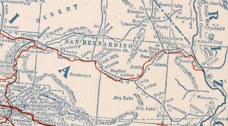
1927 Road map, western CA
Click on image to enlarge.
source
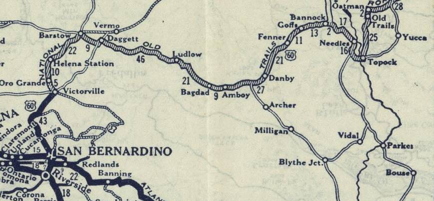
1926 Road map, western CA
Click on image to enlarge.
source
The map above (from 1926) -click on thumbnail to see large size map- shows the Highway as U.S. 60! Read why Route 66 was almost named Route 60.
This map is the first to show the alignment of a U.S. highway in Western California.
The first dirt road is shown in the map as "Old Road" (Further up in our "History" section we describe the National Old Trails Highway) and passes north of Bagdad in the Automobile Club of Southern California's Road Map of 1915 along the north side of the railroad.
In 1926 Route 66 was aligned along the N.O.T. road. and remained on it until I-40 bypassed Amboy in 1973.
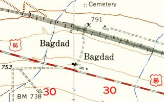
USGS map of 1956, showing Bagdad.
West of Amboy, the highway skirted the Amboy crater's lava flows and reached Bagdad (8 mi.). US 66 ran straight and then curved towards the northwest at Siberia Wash, having passed the southern tip of a mountain range (12.7 mi).
After the curve it kept on straight passing through another demolished ghost town Siberia (15 mi.)
At 16.5 mi. the railway curved away from the road in a climb out of the basin where Bagdad and Siberia are located, heading for Klondike while the road turned slightly to the north-northwest, to curve around a mountain range located to the left (west) of its course and again, curving towards the northwest (20 mi.) close to the tracks, after Klondike.
From here it ran in a straight line, while the railway went across the divide at Ash Hill further north.
Map of US 66 from Amboy to Ludlow through Bagdad.
Route 66 Alignment near Bagdad
With maps and full information on the Mother Road.
- Barstow to Pasadena (Next)
- Topock to Barstow (Bagdad's)
- Kingman to Topock (Previous)

Bagdad: Ghost town attractions
An abandoned & razed town
Historic Context
Jack Rittenhouse mentions Bagdad in his classic 1946 self-published guidebook to U.S. higway 66:
Except for a few railroad shacks, this community consists solely of a service station, café, garage and a few tourist cabins, all operated by one management. At one time, Bagdad was a roaring mining center. Between 1875 and 1910 the mountains of the Mojave were extensively exploited for their deposits of copper, silver, borax, gold, and other minerals... Rittenhouse (1946)
He added that "skeletons of abandoned cars are frequent along the roadside... a bleak desert indeed!
The same desolate view of the Mojave is given by the WPA's A Guide to the Golden State published in 1939 (2) reports that the road after Amboy was not easy for "On the vast desert, here and there, lies an abandoned auto, sometimes on its back like an upturned turtle, or an occasional little pile of rocks, marking the boundary claims of some hopeful prospector or, topped with a weathered cross, the resting place of some luckless wanderer", it goes on to describe the now ghost town:
BAGDAD (accommodations)... (787 alt., 20 pop.), is merely a shell of the rip roaring camp that thrived here when the War Eagle and Orange Blossom gold mines to the north were active. The few old buildings that escaped destruction by fire in 1918 are threatened by fierce desert winds, as a huge oil tank with its sides blown in attests. Except for one other spot, Bagdad has less rain than any other place in or near the Mojave Desert a mean annual average of but 2.3 inches; in four out of 20 years it has had no rainfall at all. WPA (1939)
It also mentioned Siberia: "For 20 miles westward US 66 covers a desolate terrain almost as primitive as it was thousands of years ago. The railroad tracks are dotted with lonely stops without accommodations, which bear such curiously incongruous names as Siberia and Klondike."
Bagdad: Ghost Town on your US66 Road Trip
Coming from Amboy after 7.5 miles you will reach the spot where Bagdad onece stood. There was, just as Rittenhouse mentioned. Below is a picture of it back in the 1930s.
Looking towards the Northeast
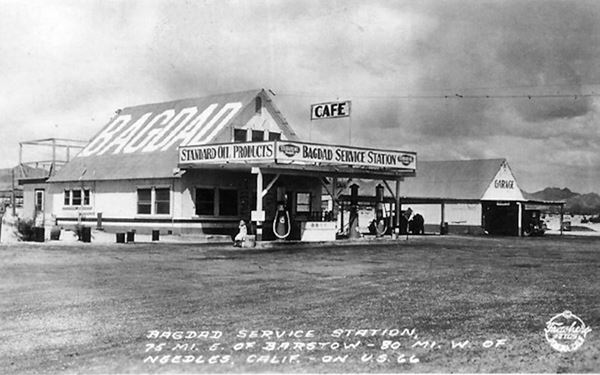
The bustling town with saloons, stores, school, passenger railway station with a Harvey House restaurant had already gone after the mines went bust. So in the 1940s all that stood was the depot and the original Bagdad Cafe.
Looking towards the Northwest
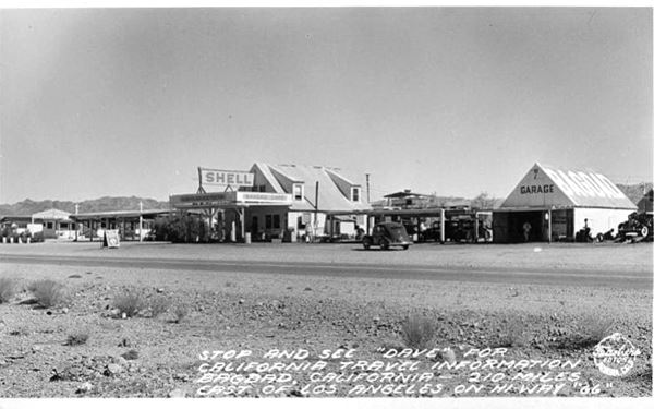
Same spot nowadays: nothing remains!
One of the garages was operated by Harry Luce who committed suicide there in 1933 (3).
There was a Shell filling station in Bagdad by 1939 as well as a garage and a café. Later the Shell changed to a Union Gas station around 1948.
After World War II, diesel engines replaced the old steam locomotives. Water stops were no longer necessary. The Santa Fe Railroad demolished the old station, but business was focused on US 66 and did so for the next 25 years
A local, Paul Limon who worked at the gas station in the 1940s and 50s recalled in an interview that the cafe was ran and owned by Mrs. Alice Lawrence and that it was the only place with a juke box and dance floor for miles around. It also offered respite for overheated cars, here they could stop and get water. Cars in those days tended to boil over (4).

Bagdad for Sale, Oct. 5, 1957. Source. Click to enlarge
In the early 1940s it appears that Mrs. Lawrence sold the property to R. W. Ragland. Fifteen years later he was still operating the motel, filling stastion, garage and cafe. He owned the 10-acre townsite just like like Roy Crowl owned neighboring Amboy. But in 1957 he decided to sell the "Whole town of Bagdad... Not the one in Asia" for $60,000 (adjusted by inflation that is roughly $652,000 nowadays). The San Bernardino Sun published an article -see image- on Sunday Oct. 5, 1957 informing that R. W. Ragland who bought the property 15 years before (1942) was putting it up for sale. He had already sold a truck business he owned, and planned on retiring, but needed to sell Bagdad. (5).
We don't know if he succeeded but nowadays you will see no buildings at Bagdad. The small community was abandoned in the early 1970s after I-40 bypassed it and business died. The buildings fell into disrepair and in 1991, the old school house and remaining structures were demolished. All you will see is a solitary tree on the north side of the road. Bagdad has gone.
Origin of Bagdad Cafe Movie

Bagdad Cafe poster. Source. Click to enlarge
Bagdad -the ghost town- was the inspiring muse for Percy Adlon, a German film producer and director who was attracted by the mysterious name "Bagdad" while driving in California with his wife and children during Christmas 1985: "We saw the name Bagdad on a map, and we went there and there was nothing: just a few trees and a rundown gas station" he said in an interview published in 2018 (6). The town was gone but the place remained in the back of his mind and that spurred him to make a movie about this middle-aged Bavarian wife stranded in the dusty desert by a cafe and motel in the middle of nowhere.
The film was shot in 1987 40 miles away in Newberry Springs because by then nothing existed in Bagdad. The location there now renamed Bagdad Cafe was in those days the Sidewinder Cafe.

Still from the movie Bagdad Cafe, 1987. Source

Still from the movie Bagdad Cafe, 1987. Source
Cemetery at Bagdad
The USGS 1956 map shown further up marks the Bagdad Cemetery on the north side of the tracks, and also several sidings next to the station (which was on the north side of the line, and the pipeline. There were several buildings at the junction of the road leading to the station and US 66.
The old cemetery is still there, abandoned in the desert. This map marks the exact location of the Cemetery. Click on it and zoom in, you can see the stones that outline some of the graves.
The graves are marked with crosses but no indication is given about those buried there. Were they Chinese railroad workers or Mexican "Traqueros", which the Southern Pacific Railroad had hired in growing quantities when it laid the track from Barstow to Needles?
Another option is some of them were the victims of the June 20 1914 Bagdad train wreck, that killed two passengers and injured eight when the east-bound California Limited train crashed into an open switch, demolishing two cars (7).
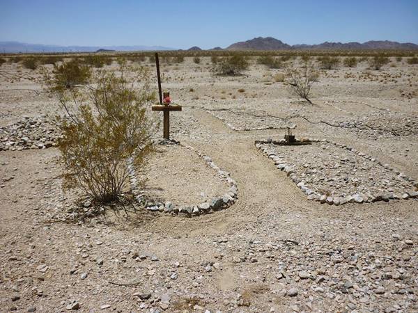
This is a cemetery and as such deserves respect, so please don't touch, don't litter, don't take anything.
Head back to the highway and continue your journey, westwards to another ghost town: Siberia, which is 7 mi. away (Map with directions).
Siberia
Ghost Town
Elevation 1,283 ft. (391 m). No population.
Siberia is another Ghost town on Route 66, it was 8 miles to the northwest of Bagdad.
The Name: Siberia
Siberia is the vast eastern part of Russia, in northwestern Asia. The name is said to derive from "Sibir" a Tartar fortress built at the confluence of the Irtysh and Tobol rivers. Which in turn comes from Tartar "Sib Ir" or "Sleeping land". Another version is that it is the name of a mysterious tribe, the "Sipyrs" who lived in the region.
The Santa Fe railroad used exotic names for sidings here: Klondike, Siberia, Siam and Bagdad are good examples.
At one time, it was a water stop for the steam locomotives. But when steam was replaced by diesel power, the station closed and only the stop for Route 66 Travelers remained. This too closed down after Interstate 40 opened in 1973, eliminating traffic along the old US 66.
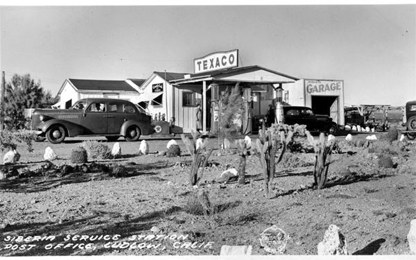
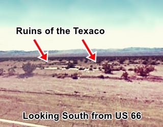
There was a store and a Texaco Gas station there with a garage since the 1930s. The foundations of this building can be seen (although it is also likely to be the remains of a railway structure), north of Route 66 as shown in the map.

Siberia USGS 1950s map, Route 66 CA.
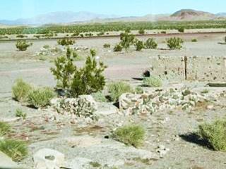
Ruins of Siberia, US66 CA. Source
See map showing where the ruins are close to the tracks, perhaps on the original N.O.T. alignment and US 66 until 1931 when it was paved and moved to its present course. There are more ruins and foundations on the south side of the highway as you can see in this map showing the Texaco Ruins.
Continue your Road Trip
Your journey through Bagdad ends here. Continue your road trip by heading west towards Ludlow.
More sights

Lake Havasu City

Lake Havasu City, the lake, and London Bridge. Source
The resort town of Lake Havasu City on Lake Havasu has beaches along the lake's scenic shoreline, an active nightlife and the original London bridge (you can take a Tour to visit it)
The adjacent state park is open 24 hs, and there is an entrance fee. It is located on a reservoir on the Colorado River. You can hike and enjoy the riverside.
Visit the scenic shoreline with beautiful beaches, nature trails, boat ramps, and many convenient campsites.
>> Book your Hotel in Lake Havasu City
Learn more about the outdoor sites in the Havasu State Park official website.
>> Book your Hotel in Barstow


Credits
Banner image: Hackberry General Store, Hackberry, Arizona by Perla Eichenblat
A Guide to the Golden State, by the Federal Writers' Project of the Works Progress Administration, Hastings House, New York, 1939.
Jack DeVere Rittenhouse, (1946). A Guide Book to Highway 66.


