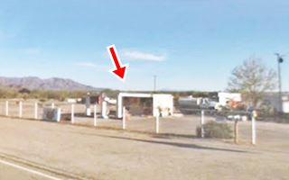
Route 66 in Chambless CA
Index to this page
About Chambless California
Facts, Trivia and useful information
Elevation 721 ft (220 m). Population n⁄a (2025).
Time zone changes as you cross the California-Arizona state line. Time zone: Pacific (MST): UTC minus 8 hours. Summer (DST) PDT (UTC-7).
Chambless is a another small unincorporated community, basically a Ghost Town set in the central-western part of San Bernardino County, in southeastern California, on "old Route 66" which here is known as the "Old National Trails Highway".
The History of Chambless, California
Visit our Needles web page to learn more about the early history of this area.
In 1884 the Atlantic and Pacific Railroad (which later was acquired by the Atchison Topeka and Santa Fe Railroad) purchased the line of its competitor, the SP Railroad from Needles to Barstow and linked its main line from St. Louis to the Californian coastal area.
It established a station and called it Cadiz, its name, like those of all the stations located east of Amboy, all the way to Needles followed an alphabetical order (there were exceptions: the small sidings between those stations, which are shown below between brackets)
Amboy, (Saltus), (Altura), Bengal - also Bristol, Cadiz, (Siam), Danby, (Arimo), Essex, Fenner, (Piute), Goffs, Homer, (Bannock), Ibis, (Klinefelter), Java, Khartoum.
So Cadiz, was the station "C" and it was located in a spot where it could supply water for the steam engines used in those days.
The name: Cadiz
Cádiz is a city and port in Spain, in the region of Andalusia, founded by Phoenicians in 1100 BC under the name of 'Gadir' which means 'walled stronghold'.
A small village sprung up next to the station and was also a rail junction as the line branch line from Phoenix Arizona which crossed the Colorado River at Parker, met the main line here. This line is nowadays the Arizona & California Railroad.
The National Old Trails (N.O.T.) highway that linked Los Angeles with New York, was built following the Santa Fe Railroad in the early 1910s, and therefore passed through Cadiz.
In 1926 U.S. Highway 66 was aligned allong the N.O.T. route. When the highway was pave din 1931, it was shortened and straightened out, and was realigned 3 miles north of Cadiz. A small comunity appeard at the junction of the road leading to Cadiz station (named Cadiz Road) and Route 66.
This community adopted the name of Chambless after the family that settled there. They had come to Amboy from Oklahoma in the 1920s (see the 1940 Census data) and two of the Chambless, Melvin and Fanny built the local service station and cabins there, on their homestead, to cater to the tourists.
The name: Chambless
This surname has two origins. One comes from a place name in France: "Chambles" means "bend", and the people from there adopted it as their family name. The other is from an occupation, the distorted form of "Chalmers" derived from Old French "de la Chambre" or the chamber attendant. The final "s" was added much later. It entered Britain with William the Conqueror after 1066 AD.
Business boomed in Chambless until I-40 was built further north in 1973, bypassing the whole of Route 66 between Ludlow and Fenner, and also Goffs. The town simply vanished, and it is a shadow of its former self.

Where to Stay: Find your Hotel near Chambless
There are plenty of accommodation options on Route 66 in neighboring Needles or Barstow so you won't have difficulty to book your room there:
> > Book your Hotel in Needles or Barstow
More Lodging Near Chambless along Route 66
Below you will find a list of some of the towns along Route 66 east and west of Chambless; click on any of the links to find your accommodation in these towns (shown from east to west):
You are so close to Las Vegas and the Grand Canyon!
>> Check out RV campground near Chambless
The weather in Chambless
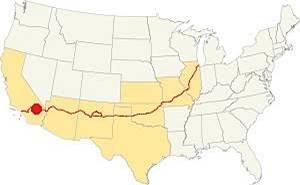
Location of Chambless on Route 66
Chambless is located in the Mojave Desert and therefore has a "Subtropical desert climate": very dry and hot.
There are 290 sunny days every year. Summer average high temperature (Jul) is a hot 107.4°F (41.9°C) and the average low is a warm 78.8°F (26°C). During winter, the average high (Jan) is 65°F (18.3°C) and the average low is a cool 37.2°F (2.9°C).
Very little rain falls in Chambless: 10.6 in. (269 mm) yearly, over 34 rainy days each year, the dryest months are April to July. Followed by the "rainy" monsoon season during summer when severe thunderstorms can take place. Snow is extremely rare with a dustiing of 3 in. yearly on average.
Tornado risk
Chambless is located far to the west of the Rocky Montains so there is virtually no risk of any tornados in this area.
Tornado Risk: read more about Tornado Risk along Route66.
Extreme Heat and Dehydration Warning
During summer make sure you stay hydrated. The hot and dry desert climate can dehydrate you quickly. Drink plenty of water and dress for the heat.
Read more how to keep healthy in hot temperatures.
Map U.S. 66 in Chambless
Read about the Topock to Barstow alignment in our dedicated webpage. Below is an interactive map of this section:
Map of this segment in Chambless.
The first alignment of Route 66 in 1926
The first highway was an Auto Trails one, built in the 1910s, a dirt track. You can see its alignment in the thumbnail map and the map below.
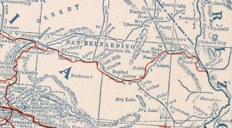
1927 Road map, western CA
Click on image to enlarge.
source
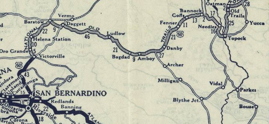
1926 Road map, western CA
Click on image to enlarge.
source
The map above (from 1926) -click on thumbnail to see large size map- shows the Highway as U.S. 60! Read why Route 66 was almost named Route 60.
This map is the first to show the alignment of a U.S. highway in Western California.
The first dirt road is shown in the map as "Old Road" and passes close to Cadiz in the Automobile Club of Southern California's Road Map of 1915. It did not show Chambless as the town did not exist at that time. The later maps of 1926 and 1927 don't show Chambless either.
In 1926 Route 66 was aligned along the N.O.T. road. The terrain to the southwest, from Danby along Route 66, is that of a broad desert valley and the road runs with a straight course across it, heading towards Bristol (also known as Iron) Mountains. There is evidence of volcanic activity in the area with lava and tuff.
The road reaches the Iron or Bristol mountains and crosses it, passing by Summit (a now defunct stop). The range is a narrow but prominent one, so the railway opted to bypass, heading around its southern end and then curving back towards the NW, into Cadiz.
Actually the road dropped slightly towards Summit from Danby, then climbed slightly to cross it and then dropped considerably into Chambless.
West of Cadiz - Chambless, the road and the tracks run between wide basins and mountain ranges and it reaches the lowest part of the basin near Amboy. The road ran in a perfectly straight line into Amboy, where it crossed to the southern side of the railroad.
Road Closures
Updated July 4 2023
Since 2017 Route 66 has been closed west of Fenner to Essex and from there, to Danby and to Chambless. There is complete information, with maps at the San Bernardino County Road Closed web page.
West of Essex, US66 is cut at Essex Rd. However Essex Rd. from Essex to I-40's exit 100 is open, so you can go along it, take I-40 westbound and then reach Chambless or Amboy and retake Route 66 has a partial cut on westbound lanes at Kelbaker Rd. But you can reach Chambless from Exit 78.
Westwards from Essex through Chambless to Amboy
As mentioned above, the old highway 66 is cut and closed to traffic between Essex and Chambless and west to Kelbaker Rd., the blue line in our map marks this segment.
Route 66 was aligned along the N.O.T. road in 1926 and after crossing the broad desert valley to the SW of Danby it crossed the Bristol or Iron Mountains through Summit, dropping down into the basin where Chambless was located in 1932 when the road was realigned further north when it was shortened, straightened, and paved.
West of Chambless, the road and the S. Fe Railway tracks run between wide basins and mountain ranges, reaching the lowest part of the basin near Amboy. The road ran in a perfectly straight line into Amboy, where it crossed to the southern side of the tracks and headed west towards Bagdad.
This is the Map from Chambless to Amboy with some detours due to road closures.
Route 66 Alignment near Chambless
With maps and full information of the old roadway.
- Barstow to Pasadena (Next)
- Topock to Barstow (Chambless')
- Kingman to Topock (Previous)
Sights and Attractions in Chambless
A Ghost Town on US 66 in the Mojave
Historic context, the classic Route 66 in Chambless
Jack DeVere Rittenhouse wrote his "Guide Book to Highway 66" in 1946 and thanks to his record, we can have a pretty good idea of what Route 66 was like during those boom days following WWII.
Nine miles southwest of Danby, Rittenhouse mentions a now defunct spot: "Summit... A handful of tourist cabins, a cafe and gas station" and he describes it as a "desert oasis".
Then, 4 miles west is Chambless:
Chambless... A wide porched gas station, with a cafe and several tourist cabins... one of the few shady spots in the entire desert route Rittenhouse (1946)
He added that there were no "towns" worth that name between Needles and Ludlow. There was an artillery range used for World War II troop training opposite Chambless. He was refering to the Mojave Anti-Aircraft Range (later Fort Irwin) which had been established there.
Driving westwards from Danby towards Chambless, you reach the Bristol -or Iron- Mountains that cut across the path of the highway, rising abruptly from the surrounding flat desert. At the top of the ridge that US66 crossed, you will spot the remains of the Summit Cafe, station and cabins.
Summit Cafe, Filling Station and cabins
It was located 3.5 mi. east of Chambless, as shown in this map with directions.
On the north side of the road (left coming from Chambless) you will see the ruins of a complex built here in the 1930s-40s. They were mentioned by Rittenhouse (see above) but nowadays the place is in ruins.
It was opened by Tom Morgan who moved there from Amboy and operated a cafe and a Texaco filling station with some cabins. He sold it to George Tienken in 1936 who ran it until 1942 and improved the facilities. They sold it to Kim and Mae Flannagan who ran it till the early 1960s and sold Standard Oil gasoline. A fire burned most of the site at that time and after a few years Dick and Nadine Cruse ran it until it closed for good when I-40 wass completed in the early 1970s bypassing Cadiz Summit.
A 1949 photograph of the Summit Service Station, café and cabins.

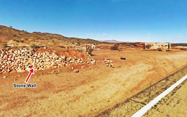
Another view of the Summit Service Station nowadays
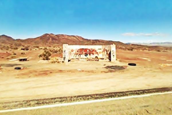
The ruins shown above are those of the garage-shed shown on the far right side of the 1949 photo and in the current view, further up, the passage of time is unrelenting.
Chambless Camp
Continuing your drive head west and at the junction of Route 66 & Cadiz Rd. to your left you will see the original store. This is the main sight in town, it is located on the southwestern corner of the junction.
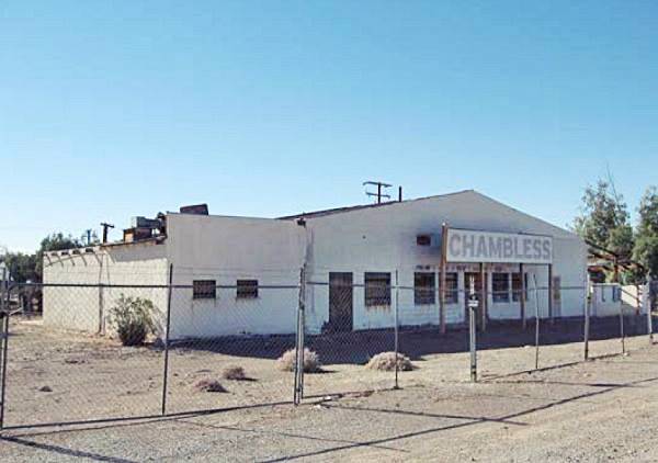
You can't miss it, as it is a large white faced building with a gabled roof, facing the highway, four cabins facing Cadiz Rd. and an office behind the main building.
It was Chambless Camp, built in 1931 by the Chambless family, inspired in the McCarty's Camp at Needles, as a one-stop-serves-all place.
It promoted itself as follows: "Modern, Fireproof, Hollow Tile Cottages. We have the only private Well, furnishing plenty of fresh water between Needles Calif. and Newberry Calif"... "On the desert - Free Showers for All".

Originally the building had a small canopy, that grew over the years into a large canopy with a gabled roof (shade was critical) over the two lanes of the gas station, it provided plenty of shade (as noted by Rittenhouse above), the park surrounding the camp had many trees too.
The cabins can still be seen, behind the main building.
The following photograph shows the Chambless Service Station in "Cadiz" in 1949:
A 1949 photograph of the Chambless Service Station by Burton Frasher.
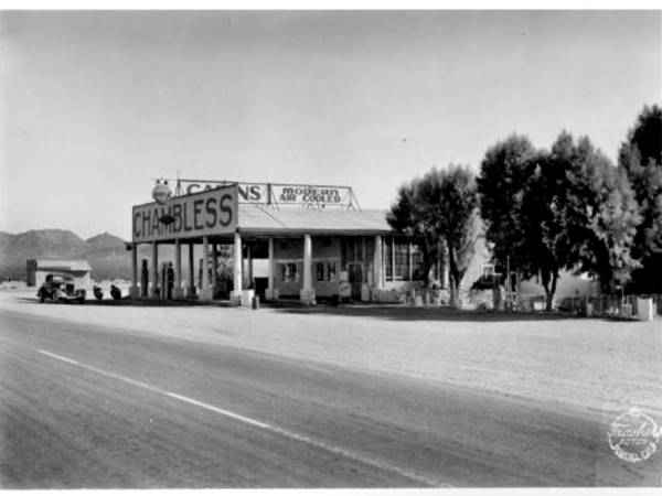
It lost its canopy over the years, but the building can still be seen standing by Route 66. Though its roof has caved in since this photograph was taken.
View of the Chambless Service Station nowadays
Route 66 shields on the road
Don't miss the U.S. highway 66 shields painted on the road's tarmac.
National Trails Highway Route 66 Marker
Across the road opposite the old camp (St. view) on the north side of the junction with Cadiz Rd., is a Marker with a plaque that reads:
Old Route 66. Perhaps no other highway in the U.S. is as fabled as Old Route 66. It has been immortalized in song, literature, and even a T.V. Series as the Main Street of America. Autumobiles came early to the desert, following the railroad with its reliable water sources. in the early 1900's the route was known as the National Old Trails Road. In 1926 it became U.S. Highway 66, and within a decade was paved all the way from L.A. to Chicago. Heavy travel by dustbowl emigrants led John Steinbeck to label it The Mother Road. Chambless, where you now stand, was a typical roadside stop. It was bypassed by Interstate 40 in 1973, and the Route 66 designation was officially dropped in 1985.
Billy Holcomb Chapter
The Ancient and Honorable Order
E Clampus Vitus
May 3, 1992
"Cadiz" Whiting Bros station ❌
There was a Whiting Brothers built a gasoline station one-quarter mile west of Chambless Camp to your left on the SW corner of Mac Tul Rd. and Route 66. You can see it to your left, the shell of the former building. This 1977 aerial photo show it with its long canopy. It closed in the 1980s (1).
Drive westwardswest for another 1.2 miles and you will reach the abandoned Roadrunner's Retreat.
Roadrunner's Retreat
Perhaps the most photographed site in Chambless, this is a former truck stop, gas station and cafe is located to your left on the south side of the highway. The Dotsons owned the property before Roy and Helen Tull took over in the ealy 1960s and like all the business catering to Route 66 travelers, it closed when I-40 bypassed them in 1973 choking off traffic.
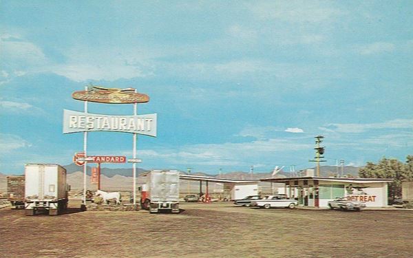
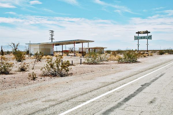
There are two buildings, one is a Service Station, with a large flat roofed canopy and the other is the former "Roadrunner's Retreat", a Restaurant and Cafe with its famous tall sign. Bill Murphy and his family owned the property since 197. The cafe partially burned and finally closed in 1995.
The mid 1960s postcard below says: "Restaurant, Standard Gasoline - 9 Miles East of Amboy - 65 Miles west of Needles on Route 66. Never Closed."
Restoring and preserving the Roadrunner Retreat
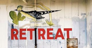
Restoration is ongoing, Roadrunner Retreat. Source. Click to enlarge
About Roadrunners
My childhood favorite was the Bugs Bunny Show, and two characters, Wile E. Coyote and the Road Runner were among my favourite. The greater roadrunner (Geococcyx californianus) is a long-legged bird related to the cuckoo family, that lives in the Southwestern United States and Mexico. Its legs aren't as long as Warner Brothers' Road Runner, but when I saw one in Suwanee New Mexico driving old Route 66, I felt great.

Roadrunner café and filing Station in 2014.
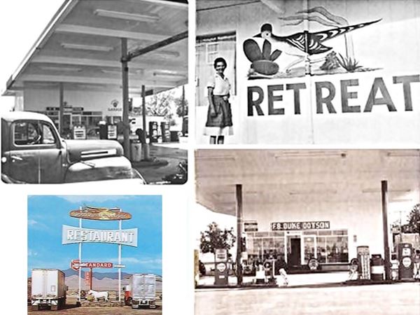
The place is being renovated, cleaned up and restored by a group of volunteers, read about their efforts: https://www.facebook.com/Roadrunnersretreat/ and https://www.roadrunnersretreat.com/.
Continue your Road Trip
Your journey through Chambless ends here. Continue your road trip by heading west into the village Amboy. Note that US66 is closed due to some bridges having been washed away, so there is a detour to reach Amboy: map.
More sights

Lake Havasu City

Lake Havasu City, the lake, and London Bridge. Source
The resort town of Lake Havasu City on Lake Havasu has beaches along the lake's scenic shoreline, an active nightlife and the original London bridge (you can take a Tour to visit it)
The adjacent state park is open 24 hs, and there is an entrance fee. It is located on a reservoir on the Colorado River. You can hike and enjoy the riverside.
Visit the scenic shoreline with beautiful beaches, nature trails, boat ramps, and many convenient campsites.
>> Book your Hotel in Lake Havasu City
Learn more about the outdoor sites in the Havasu State Park official website.
>> Book your Hotel in Barstow


Credits
Banner image: Hackberry General Store, Hackberry, Arizona by Perla Eichenblat
Jack DeVere Rittenhouse, (1946). A Guide Book to Highway 66.


