Route 66 in Amboy CA
Index to this page
About Amboy California
Facts, Trivia and useful information
Elevation 615 ft (188 m). Population 4(?) (2025).
Time zone changes when you cross the California - Arizona state line. Time zone: Pacific (MST): UTC minus 8 hours. Summer (DST) PDT (UTC-7).
Amboy is a very small unincorporated community, in central-western San Bernardino County, in southeastern California, on "old Route 66", that here is named "Old National Trails Highway".
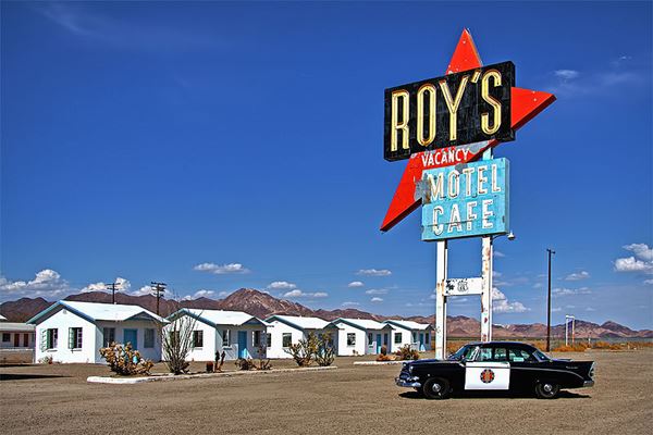
Amboy: Roy's Cafe and Motel
The History of Amboy, California
Visit our Needles web page to learn more about the early history of this area.
Pursuing its goal of reaching Los Angeles, the Atlantic and Pacific Railroad - A& P (later acquired by the Atchison Topeka & Santa Fe RR) bought the line a competitor, the Southern Pacific RR in 1884. This line linked Needles on the Colorado River with Barstow in the west.
The A&P built a station and named it Amboy a name which followed an alphabetical sequence all the way to Needles. However, as you can see belwo there were some exceptions, because the sidings were given other names (shown below between brackets)
Amboy, (Saltus), (Altura), Bengal - also Bristol, Cadiz, (Siam), Danby, (Arimo), Essex, Fenner, (Piute), Goffs, Homer, (Bannock), Ibis, (Klinefelter), Java, Khartoum.
Therefore Amboy was the first of the sequence, with the letter "A". It owed its existence to the mining wealth of the salt flats located to the south of town because water was briny and had to be brought in by railcar.
The name: Amboy
Amboy may derive from the town of Perth Amboy in New Jersey, settled in 1690 where the Amboy part of the name is a Delawere Indians place name "Embolink" or "Emboli" or "hollow on the inside" as the place resembled a bowl, a low basin surrounded by hills, and Perth comes from the city in Scotland.
Starting in the late 1800s, the gypsum was dug out of the soil, from pits and sent by a small railway to the Pacific Cement Plaster Co.'s mill at Amboy where it was processed for use as wall plaster. That and the mines in the mountains were Amboy's source of income. The plant closed for good in 1924.
The National Old Trails (N.O.T.) highway created in the early 1910s to link Los Angeles with New York crossed the Mojave Desert following the railroad. So it was routed through Amboy en route to Needles.
The Automobile Club of Southern California (ACSC) shows Amboy in its 1912 map as having gasoline. In their 1915 map, the road had shifted from the southern side of the Santa Fe Railroad to the north side, and at Amboy the road crossed back to the south side, following the older alignment. The town at that time had two "Club Signs" beside the road. By 1922 the map showed Amboy as having a Motel (perhaps J.M. Bender's hotel), Gas and Oil plus a Cemetery.
The National Old Trails Guide published in the 1920s, mentions that it had a population of 50, "Store, modern camp ground, garage and good hotel".
In 1923, the Automobile Blue Books informed about "J. M. Bender west end of Town Amboy - California General Merchandise Garage. Hotel."
Route 66 was created in 1926 and it was aligned along the N.O.T. road through Amboy. This increased the flow of traffic and created new opportunities for business.
The Great Depression slowed things down as did World War II, but after the war Amboy lived from tourists driving along Route 66 until it was bypassed by Interstate 40 in 1973. Below we will look into Roy Crowl, his wife Velma and how they made Amboy what it is today.

Where to Stay near Amboy. Accommodation
There are many lodging options close to Amboy along Route 66 in both Needles and Barstow
> > Book your Hotel in Needles or Barstow
More Lodging Near Amboy along Route 66
Below you will find a list of some of the towns along Route 66 east and west of Amboy; click on any of the links to find your accommodation in these towns (shown from east to west):
You are so close to Las Vegas and the Grand Canyon!
>> Check out RV campground near Amboy
The weather in Amboy
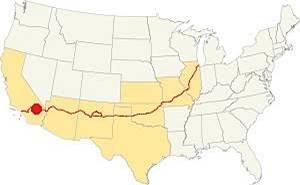
Location of Amboy on Route 66
Amboy is located in the Mojave Desert and has a "Subtropical desert climate" with very dry and hot weather. There are 290 sunny days every year.
During summer, the average high temperature (Jul) is a searing 107.4°F (41.9°C), with a very warm average low of 78.8°F (26°C). The winter average high (Jan) is a balmy 65°F (18.3°C) and the average low is a rather cool 37.2°F (2.9°C).
Rainfall is very scarce in Amboy around 10.6 in. (269 mm) every year and there are 34 rainy days each year. The dryest months are April to July which are followed by the "rainy" summer monsoon season. Watch out for severe thunderstorms during summer. Snow is extremely rare with scarcely 3 in. per year.
Tornado risk
Amboy is located far to the west of the Rocky Montains so there is virtually no risk of any tornados in this area.
Tornado Risk: read more about Tornado Risk along Route 66.
Extreme Heat and Dehydration Warning
During summer make sure you stay hydrated. The hot and dry desert climate can dehydrate you quickly. Drink plenty of water and dress for the heat.
Read more how to keep healthy in hot temperatures.
Map U.S. 66 in Amboy
Read about the Topock to Barstow alignment in our dedicated webpage. Below is an interactive map of this section:
Map of this segment in Amboy.
The first alignment of Route 66 in 1926
The first highway was an Auto trails one, built in the 1910s, a dirt track. You can see its alignment in the thumbnail map and the map below.
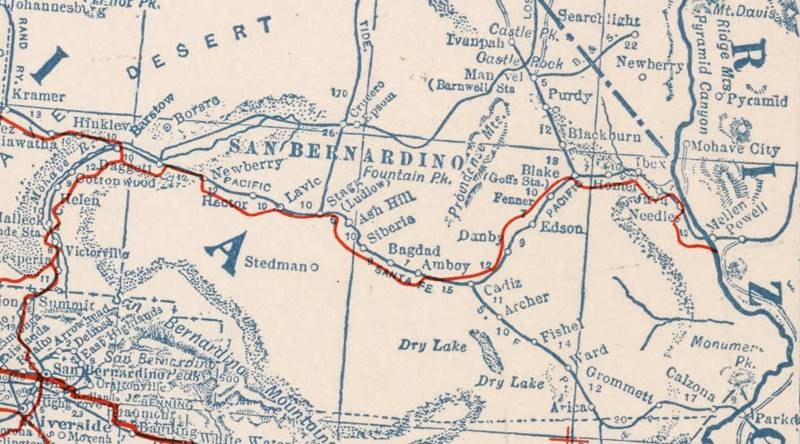
1927 Road map, western CA
Click on image to enlarge.
source
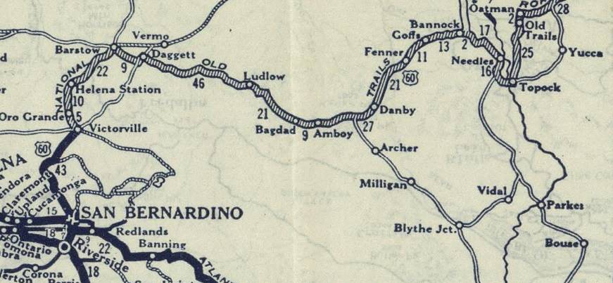
1926 Road map, western CA
Click on image to enlarge.
source
The map above (from 1926) -click on thumbnail to see large size map- shows the Highway as U.S. 60! Read why Route 66 was almost named Route 60.
This map is the first to show the alignment of a U.S. highway in Western California.
The first dirt road is shown in the map as "Old Road" and passes through Amboy in the Automobile Club of Southern California's Road Map of 1915 it ran along the north side of the railroad.
In 1926 Route 66 was aligned along the N.O.T. road. and remained on it until I-40 bypassed Amboy in 1973.
Coming from Chambless in the east, the road and the S. Fe Rairoad tracks run between wide basins and mountain ranges, reaching the lowest part of the basin near Amboy. The road ran in a perfectly straight line all the way into Amboy, where it crossed to the southern side of the tracks and headed west towards Bagdad.
This is the Map from Chambless to Amboy with some detours due to road closures.
The road, at Amboy railway depot curved towards the south to cross the A.T. & S.F. RR tracks and then curved west again, running parallel to the tracks in a straight line. Just to the west of Amboy, it skirted the lava field of the Amboy lava flow, next to the Amboy Crater (2.5 mi.) and then it kept westbound reaching Bagdad (8 mi.), the next "town" (now gone) on the highway.
Road Closures
Since 2017 Route 66 has been closed west of Fenner all the way to Essex and from there, to Danby and all the way to Chambless. There is complete information, with maps at the San Bernardino County Road Closed web page.
West of Essex, US66 is cut at Essex Rd. However Essex Rd. from Essex to I-40's exit 100 is open, so you can go along it, take I-40 westbound and then reach Chambless or Amboy and retake Route 66 has a partial cut on westbound lanes at Kelbaker Rd. But you can reach Chambless from Exit 78.
Westwards from Essex through Chambless to Amboy
As mentioned above, the old highway 66 is cut and closed to traffic between Essex and Chambless and west to Kelbaker Rd., the blue line in our map marks this segment.
Route 66 was aligned along the N.O.T. road in 1926 and after crossing the broad desert valley to the SW of Danby it crossed the Bristol or Iron Mountains through Summit, dropping down into the basin where Chambless was located in 1932 when the road was realigned further north when it was shortened, straightened and paved.
West of Chambless, the road and the S. Fe Rairoad tracks run between wide basins and mountain ranges, reaching the lowest part of the basin near Amboy. The road ran in a perfectly straight line all the way into Amboy, where it crossed to the southern side of the tracks and headed west towards Bagdad.
This is the Map from Chambless to Amboy with some detours due to road closures.
Route 66 Alignment near Amboy
With maps and full information of the old roadway.
- Barstow to Pasadena (Next)
- Topock to Barstow (Amboy')
- Kingman to Topock (Previous)
Amboy's Landmarks & Sights
Site of Roy's Motel and Cafe
Historic context, the classic Route 66 in Amboy
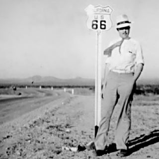
Jack DeVere Rittenhouse, Mojave Desert, Route 66 in 1941. Source
Jack DeVere Rittenhouse (1912-1991) wrote a now classic self-published book in 1946 ("Guide Book to Highway 66") that is a valuable resource for those interested in the history of Route 66 as it gives a great insight into its golden days during the Post-War period.
Rittenhouse mentions Amboy placing it mi. west of Chambless. He mentions the Amboy Crater and records Amboy's population as 165, adding that it had:
two cafes, a garage and a cafe- nothing else. Rittenhouse (1946)
Road Trip leg through Amboy
Driving westwards from Chambless, the highway follows a straight course across the desert.
Modern Landmark: Chinese lions
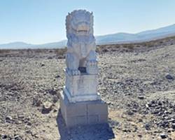
Guardian Lion, Amboy Route 66. Source
Roughly four miles east of Amboy, coming from Chambless (map marking the spot) there are two large statues about 200 ft. from the highway, to your left (south). These are traditional Chinese guardian lions. One to the east, one to the west spaced apart one-quarter mile.
They appeared around 2013 and nobody knows who placed them there. Guardian lions in China and Southeast Asia protect homes from evil spirits; they protect the place. But what do they protect here? The Mojave?
Ahead, on the eastern side of the town is the site of the unfortunante tamarisk known as the shoe tree.
Shoe Tree (gone) ❌
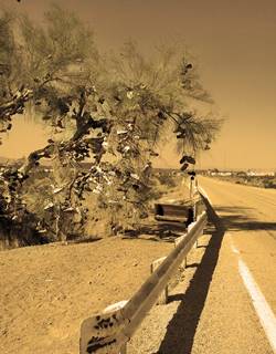
Amboy Shoe Tree. Source. Click for street view
The Tamarisk (Tamarix chinensis) also known as saltcedar, is an invasive tree in the Mojave desert. It lives by washes and rivers absorbing water and depositing sand in the soil. Its dry leaves and branches fuel desert fires but it sprouts quickly and displaces local trees and shrubs due to the salty soil it thrives in. Since it arrived in California in the early 1800s, it has endangered the native cottonwood and willow trees that also grow by rivers. Removing tamarisks is complex because an endangered bird, the southwestern willow flycatcher nests in them (lacking cottonwoods and willows to do so) meaning that the tamarisks have to be removed without harming the birds!
Tamarisks are not good for the desert environment in the Mohave
Having said this, a very large tamarisk tree grows on the eastern side of Amboy, half a mile from the Cafe's neon sign next to the bridge of a desert wash. It became a shoe tree, as people driving by began hanging shoes on its branches. The weight of these shoes plus the surface they added to the tree that increased the heat absorbed from the sun and also multiplied the wind load (force exerted by the wind on an object; think of a sail) brought the tree down in 2010 after many years of abuse by those passing by.
This map marks the spot. There was another of these trees on Route 66, the Shoe Tree in Stroud Oklahoma that perished, crushed by the shoes strung up upon it.
Personally, I am against this practice for several reasons: it contaminates a pristine place with sneakers and shoes with synthetic polymer soles, shoe laces and metal eyelets can harm the wildlife. It pollutes a place visually, it harms a living creature (the tree) and trees give shade and food to the local animals. Travel and Leave No Trace, that is the best option.
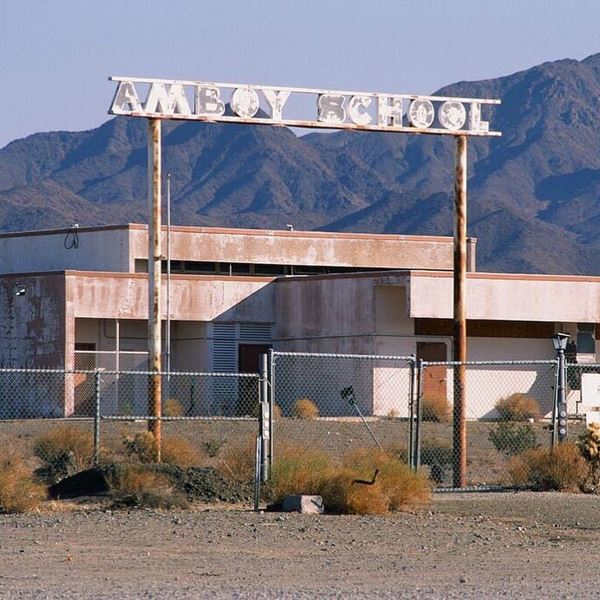
Drive west and you will reach Amboy. As you cross the bridge on the eastern side of town you will see to your right (north) the old school. It closed in 1999 due to lack of students. The gateway has some faded letters spelling "Amboy School."
Roy's Service Station, Motel and Cafe
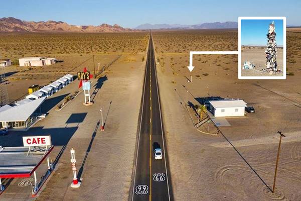
Next to the school, also to your right is the famous Roy's Motel, Cafe, and gas station the main landmark and attraction in town at 87520 Old Trails Hwy. Amboy.
The Story of Roy's
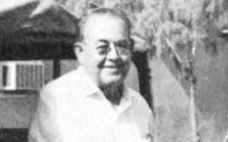
Roy Crowl, 1970. Source. Click to enlarge
The site is named after Roy Irving Crowl (1902-1977). He was born in Arizona and on their way to Los Angeles with his wife Velma in 1924, their car broke down in Amboy and Roy had to work there as a mechanic to pay for the repair job. He stayed on working at the salt mine while Velma worked at one of the cafes in town.
Both learned their trades and saved some cash. They bought some land and opened a garage. They also had a wreck truck to haul broken-down cars, something quite common in the desert in those days.
Roy recruited the help of his son-in-law Herman "Buster" Burris who also invested in the project.
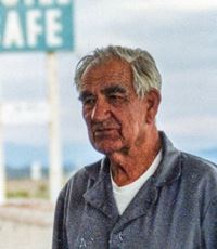
Buster Burris. Source
Herman Bazzell "Buster" Burris (1909-2000) was born in Bandera, Texas and was a pilot of the Air Corps from 1925 to 1939. He met his wife. Roy's daughter, Betty May Crowl Burris (1925-1979) in San Bernardino, where he worked as a pilot at the Air Depot, and moved with her in 1939.
They converted a room of the garage into a cafe, and added a duplex for those who had to stay overnight for repairs. They built more and more rooms to cover the demand. The cabins were built with concrete blocks and their gabled roofs gave them a neat appearance. They added an 18-room two-story block at the back. By 1952 they had 30 units.
In 1940 a gypsum and salt mill was built in Amboy and the population boomed to 600. After the war Roy, Betty and Buster continued to grow their business. Roy retired and Buster eventually owned the whole town. After Betty passed he remarried and kept on running the place.
In 1989 he felt he was too old to keep on working long shifts so he put the whole town up for sale for $2.5 million. The tag included service station, tire shop, motel, cafe, post office, airstrip, hangar, some homes and 53 acres of land in Amboy plus 40 acres east of the town (1)(2).
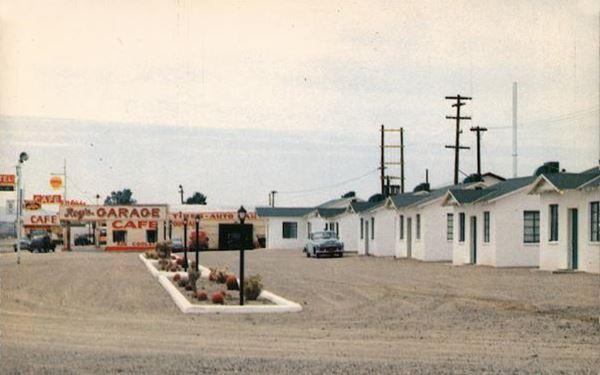
In the meantime, it was the location of the terrifying murder scene of the 1993 movie Kalifornia starring Brad Pitt (see the video warning: nasty).
The property remained unsold so in 1995 Buster leased it to Timothy White and his business partner Walt Wilson who planned to use it for movie locations. They agreed to pay $710,000 in February 2000. Buster died in August 2000 feeling he'd accomplished his goal.
But the buyers defaulted on their payments and the property was repossessed by Bessie, Buster's widow in 2005. She put it all up for sale in an auction that failed. But Albert Okura, one of the frustrated bidders came forward with a cash bid of $425,000 and bought the whole town.
Albert Okura (1951-2023) an entrepreneur who launched Juan Pollo chicken restaurant chain, was also a philanthropist keen on preserving and restoring Route 66. He had already saved the Original McDonald's stand in San Bernardino in 1998 where Juan Pollo's corporate headquarters are now located and also a museum with memorabilia about the classic landmark. Okura passed in 2023, at the age of 72 due to complications from sepsis.
His plans for Amboy included restoring the cafe, neon sign and gas station. He reopened them in 2008, but lack of infrastructure - mainly potable water - in Amboy has thwarted his plans for rehabilitating and reopening the motel have been cut short by his untimely death.
The Café's modern futuristic architecture
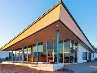
Amboy Café Googie style building. Source. Click to enlarge
The café as you can see in the picture is a classic sight, with the thick slab-like slanted "flying-V" roof over a glazed first floor, held up by slender steel poles that give it the futuristic appearance typical of "Googie architecture" (Street view).
Googie Architecture
Pronounced "gu:gi", it was a form of modern building design inspired in the Atomic and Space ages, with its geometric shapes, vast glass surfaces and symbolic motion designs (atoms, boomerangs, wing shapes, disks, and stars) with Space Age themes.
It appeared in California in the late 1940s and was popular until the mid 1960s. Cafes, motels, diners, and service stations sported these modernistic designs. And Roy's Café and its sign are clear examples of it.
1960s view of Roy's complex on Route 66, Café center.
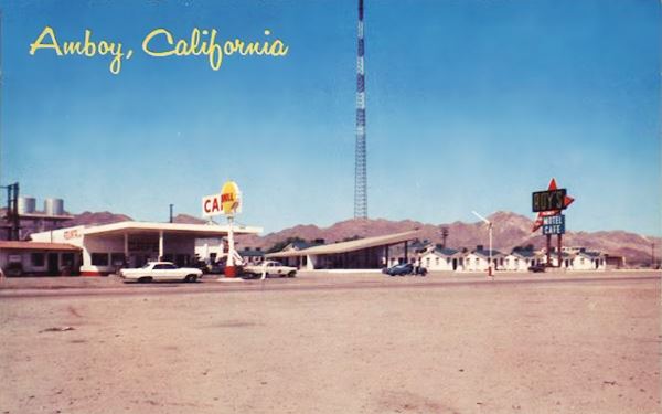
Roy's Motel neon sign
The world-famous sign was erected in 1959 during US 66's heyday. It has a bold combination of colors with the red arrow pointing at the cabins, inviting passersby to stop. Its height made it stand out from a distance. The name in yellow on a black background announced the famous attraction.
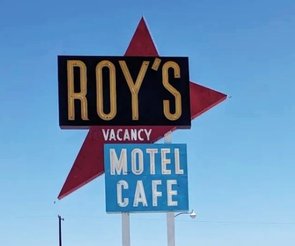
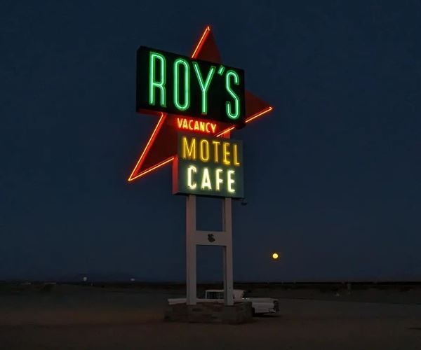
The sign has also served as a backdrop for many world-class brands' advertisements.

Olympus Advertisement.
The Motel
There is a single line with six cabins facing the highway on the right side of the cafe. And behind them the two-story motel complex. All are closed until they are rehabilitated.
The Service Station
The westernmost part of the complex is a flat foofed canopy gas station with two parallel sets of pump islands. The sign above the canopy reads "Cafe". It sold Shell gasoline in the 1960s and the old signpost with two steel tubes is still standing (without the logo) in front of the building.
The Other Cafes and gas stations in Amboy
All gone!
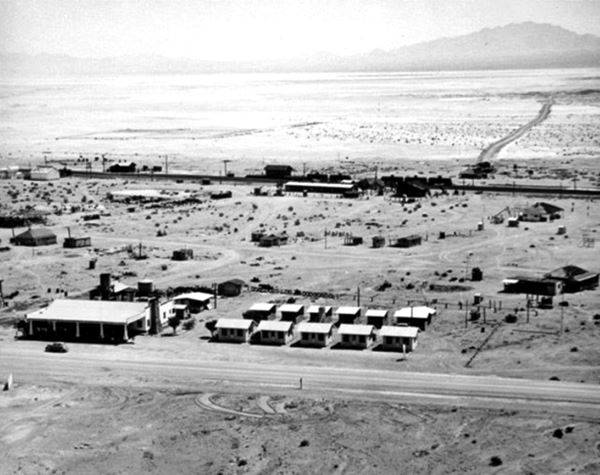
When Roy Crowl arrived in 1924, two years before Route 66 was created, the N.O.T. highway already drew considerable transcontinental and interstate traffic through Amboy. The image below shows the town in March 1925. The N.O.T. looks paved but it isn't it is an oiled dirt surfaced road.
Amboy, 1925, South is on the left, North to the right, East is bottom, West it top.
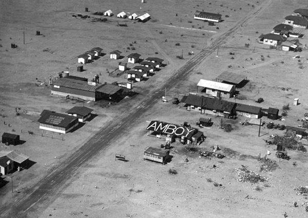
Roy's Cafe didn't exist at this time it would be built where the building with "Amboy" painted on the roof stood.
Benders Cabins and gas station ❌
The cabins and gas station on the left (south) side of the highway were those of J. M. Bender; located in front of where Roy's now stands. It had several "cabins" and a service station that resembled the one at Chambless, further east.
The image below, taken in 1940, shows Route 66, and Benders with its cabins. In the distance is the railroad and Amboy Depot. Roy's is out of sight on the lower left side of the image.
Conn's Cafe & Cabins ❌
Bender's sold out to the Conns who operated "Conns - one stop super service station" with a cafe that Constantinos "Conn" Pulos ran with his wife Lillie. Conn's Store burned in the late 1940s, but the motel and cabins survived.
Looking southeast from US 66 to Conn's in 1948.

Bill's Texaco ❌
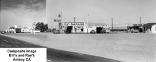
Image combines two views of Bill's and Roy's c.1940s. A. Whittall. Source 1, Source 2. Click to enlarge
On the north side of the highway (right in the 1925 picture) was Bill's Texaco and Garage. You can see it below in a view looking from the western side of Amboy. To the right is Conns that replaced Bender, to the left is Bill's. The signs at Bill's read: "Garage, Cafe, Radiator Cleaning, Texaco Service Here, Bill's Texaco Station Garage and Cafe. Air Cooled Fountain." It was located just west of Roy's Cafe.
It lasted until 1973 when I-40 bypassed Amboy and the last owners, the Kleins, moved out. It was torn down.
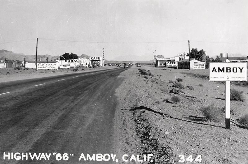
In the image (click to enlarge), I combined a picture of Bill's (left) taken by Burton Frasher in 1948 and a postcard of Roy's (right) into a new image to give an idea of what the north side of Route 66 looked like in those days. It looks towards the NW along Route 66. Below is another view looking in the opposite direction. Bill's canopy partly hides Roy's business.
Looking east along Route 66 in Amboy c.1940.
Post Office
On the south side of the highway, opposite Roy's cabins-
The post office was originally located in the store at Conn's To make more space for his customers, Conn moved it to one of the motel's cabins. Later it moved into a trailer. Finally, Buster Burris and Art Parke built the current building on its original site. The palms in front of it were planted at that time.
St. Raymond Church
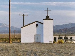
Amboy's St. Raymond church. Route 66. Source
The Catholic Church is located 500 ft. south of the post office along Amboy Rd. Roy Crowl donated the land for the church, which was dedicated in 1951 as St. Raymond Church. It closed for good on Aug. 3, 1970 and ownership reverted to Burris in the 1980s. Now it is owned by Okura's estate. The cross on its steeple was blown over by the strong desert winds. It was restored in 2018.
Clothing Post
On the south side of the highway (this map marks the spot) a modern totem to garbage? a fetish? a place thought to preserve the desert's trees from more damage (like the shoe tree)? This is a post with clothes, purses, and all sorts of junk nailed on it. Another modern bizarre and wacky landmark on old '66.
Route 66 shield on the road
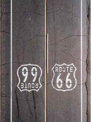
Shields on Route 66. Source
Don't miss the U.S. highway 66 shield painted on the road's tarmac, they are on both lanes, in front of Roy's service station and to the east, just past the cabins. Learn all about the shields painted on US 66.
Amboy Crater
Outdoors and Nature
National Natural Landmark
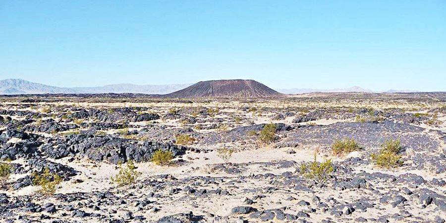
You can see the volcano ahead, from Roy's Cafe. Head west, cross the railroad and 2.5 mi. west of Roy's Cafe just south of Route 66 is the parking area. See this map with directions.
Amboy is in the lowest part of a large relatively flat basin and to the south are some dry lakes, which as salt flats yield, salt and gypsum. Towards the west, heading for Baghdad and Ludlow, you climb out of the basin going from around 600 ft. at Amboy to 1800 ft. in Ludlow.
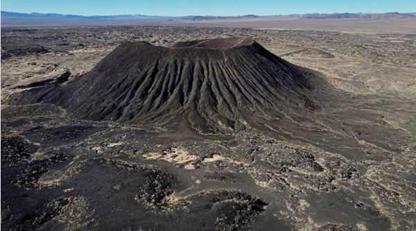
To the north lie the Marble Mountains and west, beyond Chambless is the Iron or Bristol Mountain Range.
To the west, and heading towards the northwest is a volcanic field, between Amboy and Bagdad, the Amboy Volcanic Field.
Amboy crater is a notable example of a volcano and due to its visual appeal and geological significance, it has been designated a National Natural Landmark.
The volcano, is a cinder cone that rises 250 ft. above the desert (76 m) and 1,500 ft diameter at its base (460 m). It has a crater on its summit. Its summit elevation is 945 ft above sea level (288 m).
It is relatively young speaking in geological terms: between 600 and 6,000 years old.
Inside the crater, light colored clay has accumulated, creating two small flat areas.
There is a breach on the west side of the crater where basaltic lava poured out covering 24 sq. mi. with lava, 62 km2.
The crater formed in the Barstow-Bristol trough, a fault along the boundary between the Mojave and Sonoran tectonic blocks.
Walk the Trail to the Crater
3.5 mi. round trip (5.6 km) - 2 hour trek. Trek Trail map
A trail leads up to the crater and into it. Good views. Restrooms and Shaded spots. Tables for picnics.
Check the weather conditions before your trip. It can get very hot (this is a Desert). Take plenty of water with you, hat, sun screen and look out for spiders, snakes, and scorpions.
Rittenhouse wrote, in 1946: "An extinct volcano, whose lava flow touches US 66 about 2 miles west of town. There is a footpath to the top of the carter, providing an opportunity to visit a volcano."
There are more lava flows on Route 66, like the McCartys Lava Flow (Malpais) in New Mexico, next to the town of Grants NM, which are the youngest flows in the whole of the U.S.
Continue your Road Trip
Your journey through Amboy ends here. Continue your road trip by heading west into the ghost town of Bagdad.
More sights

Lake Havasu City

Lake Havasu City, the lake, and London Bridge. Source
The resort town of Lake Havasu City on Lake Havasu has beaches along the lake's scenic shoreline, an active nightlife and the original London bridge (you can take a Tour to visit it)
The adjacent state park is open 24 hs, and there is an entrance fee. It is located on a reservoir on the Colorado River. You can hike and enjoy the riverside.
Visit the scenic shoreline with beautiful beaches, nature trails, boat ramps, and many convenient campsites.
>> Book your Hotel in Lake Havasu City
Learn more about the outdoor sites in the Havasu State Park official website.
>> Book your Hotel in Barstow


Credits
Banner image: Hackberry General Store, Hackberry, Arizona by Perla Eichenblat
Jack DeVere Rittenhouse, (1946). A Guide Book to Highway 66.


