Table of Contents
Index to this page:
>> See our custom interactive Map of this segment.
Route 66 from Topock AZ to Barstow CA
California Route 66 Itinerary and maps
Each leg of Route 66 described below has an interactive map and many image maps so you can follow the alignments of the highway along the way:
- This leg: Topock to Barstow - Map of this segment
- Barstow to Pasadena - Map of this segment
- Pasadena to Santa Monica - Map of this segment
Santa Monica End of the Trail!
Arizona, previous leg
Historic Background of this section of US Highway 66
Route 66 was created in 1926 and it used pre-existing highways as its first alignment. The original highway in the area was the "National Old Trails" a private sponsored highway created in the 1910s. It was known as an "Auto Trail" and formed part of the publics demand for "better roads"; a movement that lobbied for good highways that could be used by motor vehicles, and also signs to mark them and help drivers to find their destination.
The thumbnail (Click to see large size map), shows some of the "Auto Roads" or "Auto Trails" that could be driven by cars in 1927 in the area between Barstow and Topock. These trails are marked with red lines.
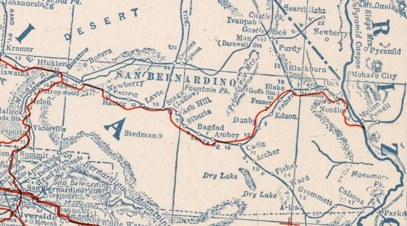
1927 Road map, western CA
Click on image to enlarge.
Credits
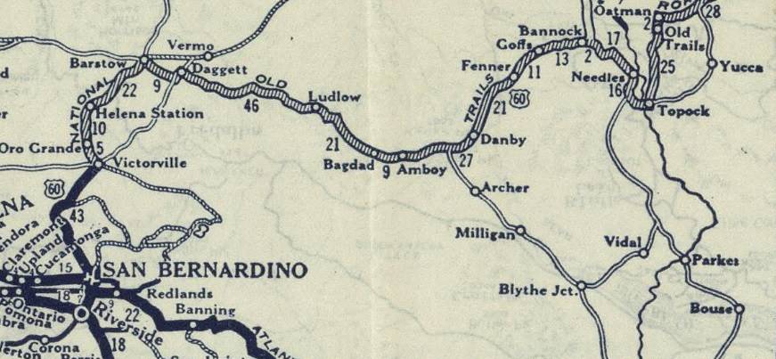
1926 Road map, western CA
Click on image to enlarge.
Credits
The map above (from 1926) -click on thumbnail to see large size map- shows the Highway as U.S. 60! Read why Route 66 was almost named Route 60.
This map is the first to show the alignment of a U.S. highway in Western California.

The bridges across the Colorado River in Topock
The bridges linking Arizona with California
Five bridges were built to cross the Colorado River south of Needles:
- The First Railroad Bridge, gone, 1883 - 1890
- The Red Rock Railroad Bridge, 1890 - 1947 Railroad Bridge (later 1947-66 U.S. 66 Bridge)
- The Trails Arch Bridge, 1916 - 1947 (Road Bridge)
- The New Red Rock Railway Bridge (since 1945)
- The Freeway Bridge, after 1966
First Railroad Bridge
The site for the first bridge was a "Eastbridge", 3 miles south of Needles. There the local workers drove pilons into the soft river bed to support the wooden bridge they would build across the Colorado River. The bridge, completed in August 1883 was washed away by the spring flood season.
A new bridge was built in 1884, and again in 1886, and in 1888. The floods and the unsuitable location for the bridge site (sandy clay soil) led the engineers to relocate the bridge further south in 1890.
Red Rock Railroad Bridge
It replaced the "Eastbridge"; the engineers chose a point further south, beyond the marshes and the mouth of the Sacramento Wash, at a narrow spot in Beal, CA, facing Topock where there was a solid rock foundation for the bridge. There they built a steel cantilever bridge, the Railway Red Rock Brige.
The steel cantilever bridge
The bridge cost over $460,000 which is more than $16 million in 2023 dollars; it was America's longest cantilever bridge.
As trains and their cargo increased in weight the bridge was reinforced in 1901 to carry heavier loads and later, a support pier was added in the middle of the span.
It is the bridge in the middle in the following image:
Looking east from California into Arizona, the three bridges.
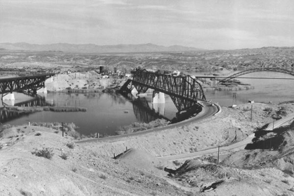
The picture above taken between 1947 and 1969 show, from left to right, the New Red Rock Railroad Bridge, the "old" Red Rock Railroad Bridge, that carried US 66 from 1947 to 1966, with the highway leaving its western tip and curving left (north), and the original Trails Arch bridge (far right) with its access road, the 1926-47 US 66 crossing the image along the bottom. Topock can be seen in the distance, in Arizona.
Trails Arch Bridge
Listed in the National Register of Historic Places in 1988.
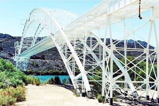
The Topock Bridge, Arizona & California. Credits
The cars that drove along the roads of the 1910s, crossed the Colorado River using the Needles Ferry. But a flood razed the ferry in 1914 so the cars crossed the river using the railroad's Red Rock Bridge: planks were laid across the tracks and the cars crossed between trains.
There was a bridge on the "Ocean-to-Ocean" route at Yuma, but the Los Angeles to St. Louis National Old Trails Highway also required a bridge across the Colorado River
In 1914, the states of Arizona and California, the US Bureau of Indian Affairs and San Bernardino County agreed to build a bridge.
The structure is a steel arch bridge with a "cantilever system" where the arch was assembled in two halves on each side of the river and then hoisted into place and linked together with a ball-and-socket central hinge.
At 800 ft. (243 m) in length and with a span of 600 ft. (182 m), it was the longest arch bridge in America until 1928.
The bridge was completed on Feb. 20, 1916 and carried the traffic of the N.O.T. highway. In 1926, U.S. 66 was aligned across it and remained so until 1947 when it was replaced by the Red Rock Bridge which the AT&SF railroad had just stopped using.
Its deck was removed in 1948 and a natural gas pipeline was laid across it; it is still in use.
We marked the course of the 1926-47 Route 66 from Topock AZ to California across this bridge with a pink line in our custom map of Route 66 in California.
Viewing the Trails Arch Bridge
From the California side of the river you can get a good view the old Arch Bridge from this vantage point (Map and Directions from Topock AZ), there is a concrete billboard and a parking space. The Billboard says "Welcome, Turn Right Next Exit" with a Route 66 shield.
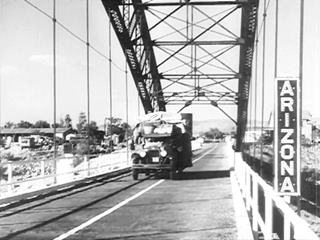
Dust Bowl and the Great Depression, "Grapes of Wrath", US66 and the Colorado River Bridge
The black and white image is a still from the movie "The Grapes of Wrath" showing the Joads crossing the Colorado River along the steel arch bridge in 1940.
The Grapes of Wrath and the Trail
The book by John Steinbeck and the movie it inspired, directed by John Ford (1940), portrayed the tragic story of an Oklahoma family, the Joads, who lost their farm during the Great Depression and migrated to California seeking new opportunities.
In this Pulitzer Prize-winning work, Steinbeck (who later won the Nobel Prize in Literature) depicts their tragic journey (along Route 66). He also coined the phrase "Mother Road", referring to U.S. 66.
>> Learn more on our Grapes of Wrath page.
New Red Rock Railroad Bridge
The heavy military cargoes during World War II led the AT&SF railroad to plan and build a new bridge just north of the original one.
It was completed in February 1945: a high level double-track bridge. This bridge is still in use today.
Route 66 Red Rock Bridge: Carried vehicles after 1947
The Trails Arch Bridge was a very narrow bridge and only one lane crossed it, it also had a sharp 90° turn on the Californian side. It had a low carrying weight (11 tons); as trucks carried heavier loads a new bridge became necessary.
When the railway completed the "new Red Rock Bridge" the "old" bridge was modified to accommodate U.S. 66 trafic in 1947 and continued carrying traffic until it was replaced by the I-40 bridge in 1966. The old steel structure was removed in 1978.
We marked the course of the 1947-66 Route 66 from Topock AZ to California across this bridge with a dark blue line in our custom map of Route 66 in CA.
These two aerial photographs reflect the changes over the years:
This aerial photograph taken in 1947 shows, from top (north) to bottom (south), the three bridges that crossed the Colorado River at that time. The 1969 aerial photo shows all bridges, including the one carrying I-40.
Into Needles California
The construction of I-40 and the removal of the Red Rocks Bridge as well as the new use given to the Trails Arch Bridge as altered the original roadbed of old Route 66 in the Colorado River bridges area, you will have to cross the river into California using I-40. However, ahead you can drive along the 1930s alignment, this map map to the vantage point.
The vantage point overlooks the Colorado river and has a great view of all the bridges it takes you to the western bridgheads of all the historic bridges. To reach the vantage point leave I-40 at Exit 153 and head north along Park Moabi Rd. for 1⁄2 mi. until reaching the National Trails Highway. Take a right and follow it eastwards and then south. You will pass under I-40 and reach a parking area next to the "Welcome" Sign of Route 66 on the western tip of the now demolished "Red Rock Bridge"
This is also the starting point of Route 66 in California. One of the hottest and driest parts of the Route 66 alignment, in the Mojave Desert region, which was the toughest on both drivers and vehicles in the old-days.
We will follow the 1930s alignment northwards into Needles. Retrace your steps to Park Moabi Rd., but instead of turning keep straight ahead. The National Trails highway turns towards the SW and paving ends.
The road ahead is unpaved, it has boulders, gravel, loose sand and potholes, it is difficult, rough, with off-road sectors.
If your feel you can drive it, you can continue along this dirt, gravel and sand road. As shown in this map. It passes under I-40 (orange line in our custom map) where it runs along a dry river bed and heads west, the road curves towards the NW and runs parallel to I-40 until reaching the "Five Mile Road" at I-40s Exit 148. Here the paving begins again.
A more reasonable option, for all of us who don't fancy driving along difficult dirt roads you can take an easier route: From Park Moabi, get back on I-40 at Exit 153 and head westbound until Exit 148, leave it there (6 mi.), turn west until you meet the paved "Five Mile Road" just west of the Interstate (map with directions), the road turns north and meets U.S. 95, it continues nortwards, now as US 95, passes under I-40 (at Exit 144) and enters Needles along Broadway Street.
Needles
The town was named after the peaks of a mountain range located further south, sharp like needles.
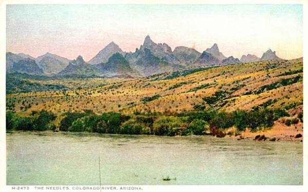
Needles was the Western Terminus of Route 66
On Aug 26, 1963 the state's Higway Commission (CHC) requested the "Elimination of Route 66... Between Jct. U.S. 95 Needles and Santa Monica" it was approved by the AASHO on Nov. 14, 1963. I-40 and I-15 replaced the former alignment between Needles and Santa Monica. At the same time the state had also requested eliminating Alt 66 from Pasadena to Los Angeles through Eagle Rock. This was also authorized. 1
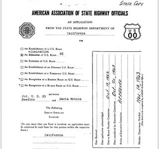
End of Route 66 moved from Santa Monica to Needles, 1964. Source.
Click image to enlarge
The first segment of Route 66 to lose its certification was the one located in Los Angeles County in 1964, it was replaced by State highways Route 2 and Route 11.
The western terminus of Route 66 was "officially" moved from Santa Monica to Needles in 1964 using I-15 and I-40 all the way from San Bernardino to Needles. However, the state's Highway Commission included the alignment of Route 66 between Pasadena and Needles in its maps until 1970 as shown in the map image. Also see more maps with US 66 shields by the CHC after 1964.)

1970 Road map, western CA
Click on image to enlarge.
Credits
When I-40 was completed across the Bristol Mountains in 1972 (2) or 1973 (3). US 66 was decommissioned all the way from Pasadena to the "intersection of U.S. 95 near Needles, California."
There were two intersections with U.S. 95, the terminus was moved to the eastern intersection on the south side of Exit 144 of I-40 (Red arrow). See the 1970 map (click on it to enlarge it).
At the request of both California and Arizona highway departments, the American Association of State Highway and Transportation (or AASHTO) decided to move it again on June 20, 1979 from this point just south of Needles to Sanders Arizona. This marked the end of Route 66 in California. The Western Terminus of Route 66 remained in Sanders until the whole highway was eliminated in 1985.
Decertified in California and most of Arizona - 1979
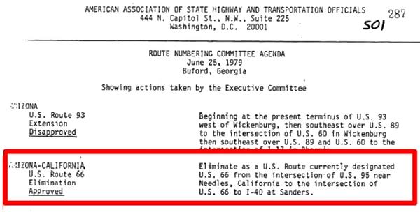
The Route 66 in Needles
The highway crosses the town along Historic Route 66 and Needles Highway as shown in this map of US66 in Needles.
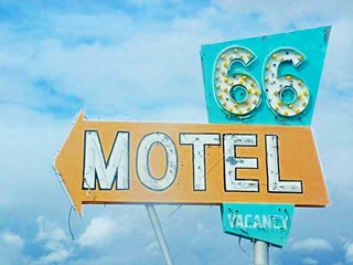
Route 66 Motel sign in Needles, California,
Source

Needles USGS map, 1952. Route 66 alignment
As the USGS map above shows, Route 66 took a right here on G Street and passing by the west wing of El Garces Hotel, turned west again along Front Street and crossed the railroad with a grade crossing at N Street. See it also in this 1947 aerial photo.
Later the highway was realigned along Broadway when the railroad viaduct was built in 1965 to accommodate the ramp and curve that couldn't be built safely using Front St.
However, before the freeway was built and until the early 1969s, when the overpass was built over the tracks on the west side of the town, the highway followed the alignment marked with a yellow line in our map, along Front Street with a sharp turn north along N St. There is another gap at Exit 141 where the original road was cut to make space for the Exit, this red line marks it in our custom map, a new alignment was built to link the segments. And the section shown in this map was removed from the alignment.
West of Needles lie the Sacramento, Piute, and Old Woman mountains which run with a NE to SW direction, more or less parallel to the Colorado River. They had to be crossed to reach the Mojave desert and California's west coast.
The first to do so was the railway, and its engineers chose a long wide arch towards the north. The National Old Trails (N.O.T.) road followed the tracks in the early 1910s. By 1912 Needles already had gasoline and by 1924 it had a hotel and a garage. The N.O.T. guide printed in the 1920s informed that the village had "Free ice water, splendid store, camp ground garage, a cool place on Mojave Desert".
When U.S. Highway 66 was created in 1926, it was aligned along this original N.O.T. roadbed it remained on it for many years.
West of Needles
The highway left Needles along Needles Highway (see map further up), there is a gap at West Park Rd. and our custom map marks this missing segment with a turquoise line, west of this point the highway from 1926 to the 1960s is buried under the freeway so you have no option but to drive along I-40.
Thunderstorm looms over the Mojave in California.
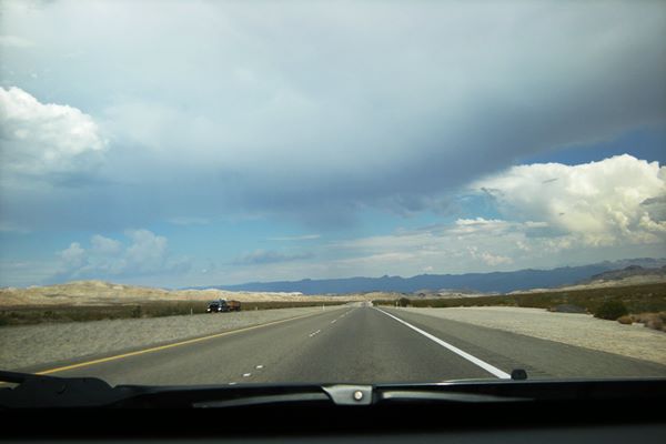
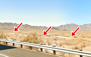
Further north the highway and railroad curve west and I-40 crosses the tracks. Here the 1926-50s alignment splits from the freeway; we marked this old roadbed with a violet line in our custom map. The image shows (red arrows) the old roadbed here.
Goffs
There is a fork just ahead. The 1926-31 highway turns north towards Las Vegas heading to Homer and Goffs. The map shows the gap in magenta. To drive this section from Needles to Goff, you will have to use I-40 and US 95, this is the 1926-1931 Route 66 map from Needles to Goffs.
In those days, Goffs was on the main road between Los Angeles and Salt Lake City, because the corridor now used by I-15 did not exist.
Traffic went through Goffs and then took a right along a dirt road that went to Utah passing through Searchlight and Las Vegas in Nevada.
The road to Nevada and Utah split from Old Route 66 at "Arrowhead Junction" (on what now are Route 66 & US 95) and this road was known as "Arrowhead Highway" (Arrowhead Junction map).
Fenner
From Goffs, the highway curved south to Fenner (map with directions) where there is a gap due to I-40 cutting across the old road and a road closure by the DOT from Exit 107 all the way to the junction with the N.O.T. Highway north of Essex (green line in our custom map).
The 1931 alignment of Route 66
In the early 1930s, route 66 was realigned, shortening it and paving it, improving bridges and shoulders. The Needles to Essex section was no exception.
A shorter alignment six miles south of Goffs was built across the Piute Mountains. It had a steeper grade than the older road, but cut off 8 miles from the original 1926 alignment.
The new road opened on Dec. 4, 1931, and Goffs was bypassed.
It followed the earlier road up to Klinefelter Spring, and then headed straight west, passing through Mountain Spring Camp. It met the 1926 alignment 3 mi. south of Fenner and 2 mi. north of Essex.
See the 1931 - 1960s Route 66 map from Needles to Essex. Its first section to I-40's exit 115 is overlaid by the Freeway.
This was the road used by Rittenhouse in 1946, who describes it in his Guidebook as follows: the road went along the west bank of the Colorado River and then turned west towards the mountains, crossing them 20 mi. from Needles via the South Pass (2,650 ft.) (here was a gas station there).
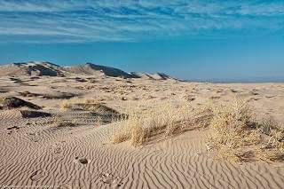
Kelso Dunes in Mohave Preserve CA. Source
1940s Roadtrip adventures
In those days cars had no airconditioning, they were slower and tended to overheat.
So Rittenhouse recommended back in 1946 that during summer "it is advisable to make the drive from Needles to Barstow, over the Mojave Desert, either in the evening, night or early morning hours"; he also suggested carrying extra water in case the car overheated.
Ten miles west of the pass, Route 66 reached Mountain Springs (now gone) with gas, lunchroom, cabins and a garage. Surprisingly Water had to be paid for unless you loaded gas!
Essex
The road then dropped down towards the Mojave Desert and, 44 miles from Needles, it reached Essex with 55 residents, gasoline, diner, small grocery and a post office.
Road Closures
Updated January 31 2024
Since 2017 Route 66 has been closed west of Fenner all the way to Essex and from there, to Danby and all the way to Chambless. There is complete information, with maps at the San Bernardino County Road Closed web page.
West of Chambless US66 is cut at so from Essex go to I-40's exit 100 is open, so you can go along it, take I-40 westbound and then reach Chambless or Amboy via Exit 78.
Westwards from Essex to Danby to Amboy
As mentioned above, the old highway 66 is cut and closed to traffic between Essex and Chambless, this includes Danby, the blue line in our map marks this segment.
Danby
This first N.O.T. westwards from Danby crossed at Danby Station to the eastern ⁄ southern side of the Santa Fe tracks. It remained on that side all the way to Ludlow, passing south of Amboy station.
The Automobile Club of Southern California's Road Map of 1915 shows that road from Danby to Amboy had by then been moved to the northern side of the Santa Fe R.R. and Amboy was shown wiith Gasoline and Oil.
Route 66 was aligned along the N.O.T. road in 1926 and after crossing the broad desert valley to the SW of Danby it crossed the Bristol or Iron Mountains through Summit, dropping down into the basin where Chambless was located in 1932 when the road was paved.
Chambless
West of Chambless, the road and the S. Fe Rairoad tracks run between wide basins and mountain ranges, reaching the lowest part of the basin near Amboy. The road ran in a perfectly straight line all the way into Amboy, where it crossed to the southern side of the tracks and headed west towards Bagdad.
This is the Map from Chambless to Amboy with some detours due to road closures.
Amboy
The road, at Amboy railway depot curved towards the south to cross the A.T. & S.F. RR tracks and then curved west again, running parallel to the tracks in a straight line. Just to the west of Amboy, it skirted the lava field of the Amboy lava flow, next to the Amboy Crater (2.5 mi.)
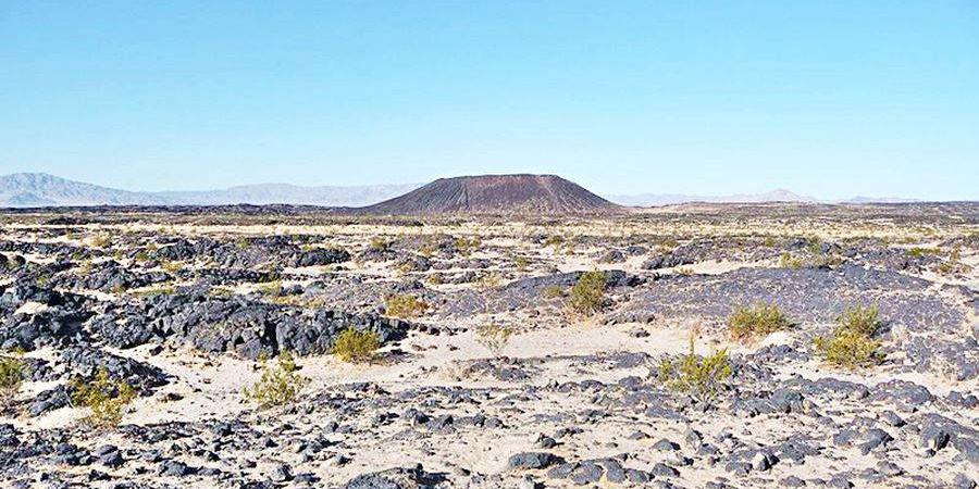
Bagdad
It kept westbound reaching Bagdad, (8 mi.), now a razed ghost town of which only the cemetery remains. US 66 ran straight and then curved towards the northwest at Siberia Wash, having passed the southern tip of a mountain range (12.7 mi).
After the curve it kept on straight passing through another demolished ghost town Siberia (15 mi.)
At 16.5 mi. the railway curved away from the road in a climb out of the basin where Bagdad and Siberia are located, heading for Klondike while the road turned slightly to the north-northwest, to curve around a mountain range located to the left (west) of its course and again, curving towards the northwest (20 mi.) close to the tracks, after Klondike.
From here it ran in a straight line, while the railway went across the divide at Ash Hill further north.
Ludlow
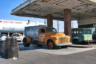
Two old trucks at the Service Station in Ludlow. Source
Route 66 crosses the tracks in an overpass (25.7 mi.) and then turns west, running between I-40 (right) and the railroad (left). Main Street branches off to the left at mile 27.5 as it enters Ludlow, the road passes by several derelict buildings (motel, cafe, service stations), reaching the main junction in town, at Main Street and Ludlow Road (Route 66) just south of I-40's Exit 50 (28.2 mi.)
The Alignment of Old Route 66 in Barstow
Ludlow to Newberry Springs
The road, from Ludlow to Newberry Springs originally headed west from Ludlow Cafe on the south side of what is now I-40 for 1.3 miles, after which it is now cut by the freeway, see the orange line in our custom map; it continues on the north side as the National Trails Hwy., you will have to head to the north of I-40 at Exit 50, take a left and go west.
Ahead, at Argos there is another gap where the original highway curved to the south at a wash, we marked it with a pink line in our custom map.
At Lavic (8.5 mi.) the National Trails Highway crosses to the south side of I-40 and turns right (west) at Lavic Rd. it crosses to the south of the SF railroad (level crossing at 11 mi.) and runs beside the Lavic Lava Field, a black jumble of basalt to your left. The gap here is marked with a green line in our custom map.
Newberry Springs
It keeps to the south of both railway and Interstate, all the way into Newberry Springs 31.6 miles from Ludlow.
This is the modern alignment of US 66 that can be driven from Ludlow to Newberry Springs.
From Newberry Springs to Daggett
1926 - 28 alignment
The road, from Newberry Springs to Daggett ran on the south side of the tracks of the Santa Fe Railroad up to Minneola, a small train stop. There it crossed to the north side of the tracks (see the violet line in our map and went through Daggett along Santa Fe St. (map, crossing to the south of the railway at the Dagget - Yermo Rd. and then turning west and heading straight towards Barstow.
1928 realignment
US 66 was realigned to shorten it and make it safer so the two grade crossings were eliminated and the road kept a straight course west of Minneola, on the south side of the SF Railraod. Just west of that station, it passed through the California Agricultural Inspection Station. It bypassed the old commercial district in Daggett.
Daggett to Marine Base at Nebo
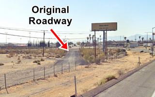
West of Daggett, the original roadway passes through a military facility, now it can't be driven. We marked this gap at Nebo with white line in our custom map. Part of the old alignment can be seen on the north side of the highway at Exit 2 (see image).
To bypass the Base you must take a detour at Nebo St., head south to I-40 (Exit 5) and head west to bypass it. Get off I-40 at Exit 2 and head west along E. Main St. in Barstow (map Daggett to Barstow).
Into Barstow
At Exit 2, follow E Main St. westwards and take a right at Montara Rd. passing under I-40 head north. Here is another gap caused by Exit 1, we marked it with a violet line in our custom map. The highway heads to the N.E. as East Main St. curves as it meets the SF tracks. The road then crosses over I-15. Keep on Main Street all the way into downtown Barstow.
This marks the endpoint of this segment on the eastern side of Barstow. Ahead lies the Mojave River valley and Cajon Pass the access to San Bernardino and Los Angeles.
Accommodation: Hotels along this leg of your road trip
Topock has plenty of lodging options for those travelling along Route 66, you can book a hotel or motel there:
> > Book your Hotel in Needles
More Lodging Near Needles along Route 66
Below you will find a list of some of the towns along Route 66 east and west of Needles; click on any of the links to find your accommodation in these towns (shown from east to west):
You are so close to Las Vegas and the Grand Canyon!
Continue your Route 66 Road trip:

Sponsored Content
>> Book your Hotel in Barstow

Credits
Banner image: Hackberry General Store, Hackberry, AZ by Perla Eichenblat
Jack DeVere Rittenhouse, (1946). A Guide Book to Highway 66.


