Route 66 in Fenner CA
Index to this page
About Fenner, California
Facts, Trivia and useful information
Elevation 2,100 ft (600 m). Population 2023 n⁄a (2025).
Time zone changes as you cross the California - Arizona state line. Time zone: Pacific (MST): UTC minus 8 hours. Summer (DST) PDT (UTC-7).
Fenner is an unincorporated community located in western San Bernardino County, in southeastern California.
View of Fenner from Route 66
Fenner's History
Check our Needles page for the early history of the region.
After the natives were subdued in Arizona, the transcontinental rail link was built by two competing railroads: The Huntington and the Southern Pacific (SP) which laid a line from Barstow to Needles across the Mojave in 1883 and the Atlantic and Pacific Railroad (A&P) from New Mexico westwards. SP sold its line to A& in 1884 and later it was absorbed by the AT & Santa Fe Railway.
Fenner was a siding on this railroad, in the Mojave, on the western flank of the Piute range of mountains and was named due to a curious method used by the railroad: all the watering stations for the steam engines between Amboy and Needles were named following an alphabetical order from west to east (however there were exceptions: the small sidings between those stations, shown below between brackets)
Amboy, (Saltus), (Altura), Bristol, Cadiz, (Siam), Danby, (Arimo), Essex, Fenner, (Piute), Goffs, Homer, (Bannock), Ibis, (Klinefelter), Java, Khartoum.
The name: Fenner
A Fen is a wetland, like a bog; a low lying marshy area. And a "Fenner" (also Venner) was either a person who lived in a fen. The surname is found in Germany, Britain and the Netherlands. Later it was applied to those who drained fens, dissecating them, a process that began in the 9th century.
It was merely a stop on the railroad until in the 1910s the National Old Trails Highway (N.O.T.) was built from Los Angeles to Needles, passing through Fenner. This brought a growing flow of travelers and a service station opened in 1912. By 1915 it had added "meals - lodgings".
The road of course was unpaved, and south towards Essex railroad dept there was "light sand" (in those days Essex offered no services to the traveller either). This first road, ran further to the west of the Santa Fe Railroad; in the early 1920s it was realigned near the tracks.
By 1924 Fenner had "Hotel, Gas, Oil" and in 1926 when US 66 was created, it was aligned along the old N.O.T. highway.
Despite being in the Mojave Desert, the "town" got its water from Fenner Spring, located Southeast of the settlement in the Piute Mountains, so trees could grow under irrigation.
But prosperity did not last. Only five years later Route 66 was realigned, bypassing Fenner. The new paved road ran with a shorter and straighter course 3 miles south of Fenner. This led to the demise of Fenner and the growth of Essex (which was located on the new alignment). Route 66 is now known as Goffs Road.
When I-40 was built across the desert, an Exit (107) was built just next to Fenner, so the famous Gas station there does get plenty of customers but it has no relation to the original alignment.

Where to Stay: Find your Hotel near Fenner
There are plenty of accommodation options on Route 66 in neighboring Needles and Barstow so you won't have difficulty to book your room there:
> > Book your Hotel in Needles or Barstow
More Lodging Near Fenner along Route 66
Below you will find a list of some of the towns along Route 66 east and west of Fenner; click on any of the links to find your accommodation in these towns (shown from east to west):
You are so close to Las Vegas and the Grand Canyon!
>> Check out RV campground near Fenner
The weather in Fenner
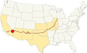
Location of Fenner on Route 66
Fenner is in the Mojave and has very hot weather, with a "Subtropical desert climate" that is both dry and hot, with strong thunderstorms during the summer monsoon season.
Summer average high (Jul) 109.4°F (43°C) and average low 78.8°F (26°C). During winter, the average high (Jan) is 68°F (20°C) and the average low 42.8°F (6°C).
Rain is scarce in Fenner; only 6.8 in. (173 mm) fall every year with only 25 rainy days per year with April to July being the dryest period. Snow is very uncommon.
Tornado risk
As Fenner is located far to the west of the Rocky Montains there is virtually zero risk of tornados in the area. Tornado Risk: read more about Tornado Risk along Route66
Extreme Heat and Dehydration Warning
During summer make sure you stay hydrated. The hot and dry desert climate can dehydrate you quickly. Drink plenty of water and dress for the heat.
Read more how to keep healthy in hot temperatures.
Map U.S. 66 in Fenner
Read about the Topock to Barstow alignment in our dedicated webpage. Below is an interactive map of this section:
Map of this segment in Fenner.
The first alignment of Route 66 in 1926
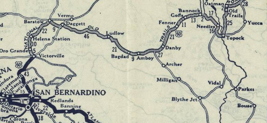
The first highway was an Auto Trails one, built in the 1910s, a dirt track. Map below. Fenner appears in it.
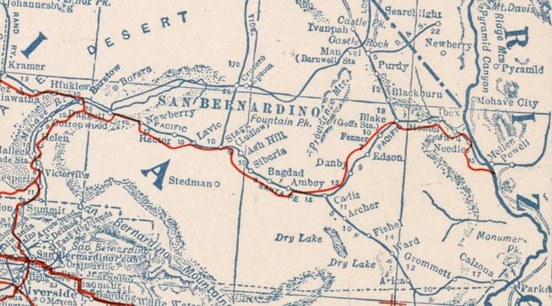
1927 Road map, western CA
Click on image to enlarge.
source
1926 Road map, western CA
Click on image to enlarge.
source
The map above (from 1926) -click on thumbnail to see large size map- shows the Highway as U.S. 60! Read why Route 66 was almost named Route 60.
This map is the first to show the alignment of a U.S. highway in Western California.
Driving westwards from Goffs the 1926 to 1931 highway curved south towards Fenner (map with directions) where there is a gap due to I-40 cutting across the old road and a road closure by the DOT from Exit 107 to the junction with the N.O.T. Highway north of Essex (green line in our custom map).
The 1931 alignment of Route 66
In the early 1930s, route 66 was realigned, shortening it and paving it, improving bridges and shoulders. The Needles to Essex section was no exception.
A shorter alignment six miles south of Goffs and Fenner was built across the Piute Mountains. It had a steeper grade than the older road, but cut off 8 miles from the original 1926 alignment.
The new road opened on Dec. 4, 1931, and Fenner was bypassed.
It followed the earlier road up to Klinefelter Spring, and then headed straight west, passing through Mountain Spring Camp. It met the 1926 alignment 3 mi. south of Fenner and 2 mi. north of Essex.
See the 1931 - 1960s Route 66 map from Needles to Essex. Its first section to I-40's exit 115 is overlaid by the Freeway.
Route 66 Alignment near Fenner
With maps and full information of the old roadway.
- Barstow to Pasadena (Next)
- Topock to Barstow (Fenner)
- Kingman to Topock (Previous)
Getting to Fenner
You can reach the town driving along old Route 66 or I-40 at Exit 107, and also from Las Vegas, Nevada, along US 95.
Fenner its attractions: the Oasis
Historic context, the classic Route 66 in Fenner
In 1946 Jack DeVere Rittenhouse drove along US 66 gathering information for his "Guide Book to Highway 66". At that time, 15 years had already passed since Fenner had been bypassed by the realignment of Route 66 further south into Essex. For that reason we have no reference from Rittenhouse about Fenner.
The original settlement around the railroad tracks and depot were located on a segment of the National Old Trails highway that was eliminated when the access to the freeway's exit at Fenner was built. I-40s overpass across the tracks meant that the access ramps had to be built further from the tracks, a new roadway was built, curving west towards the exit and then back towards the old road south of the interstate. The original road at Exit 107 is marked with a green line in our custom map.
As you can see in this 1977 aerial photo long after Fenner had been bypassed, there were some buildings there, at the fork on the north side of Fenner (where the curve begins) and along the now erased alignment 900 feet further south. The modern gas station hadn't yet been built.
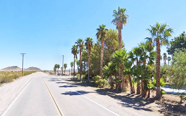
As shown in the vintage image below, which looks north along US66, Fenner had many buildings in the 1920s: to the left is the "Hotel Fenner", and there are many trees along the highway. The railway tracks can be seen to the right side of Route 66.
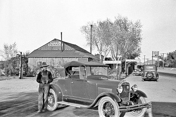
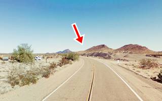
Nowadays as you can see in the image, this same area is dry, parched and with no buildings or trees. The red arrow marks the same hills that can be seen in the vintage photograph further up.
Gasoline Station
To your left, at 31251 Goffs Road, Fenner. The "Hi Sahara Oasis Inc" filling station has an air of a Saharan Oasis with its palm trees and clear water ponds. The kitschy statues are a great example of Route 66 Americana.

The statues in the ponds at Fenner.
To the west, you can see a range of mountains, 10 miles long, which is named Clipper Mountain. It was formed by Tertiary volcanic rocks with peaks of over 1,500 ft. high. The slopes ar yellow, brown due to the oxidation of the lava. Fenner lies in a valley between Clipper and Paiute Mountains.
Historic WW II marker on the Freeway
Eastbound Rest area before Exit 107, I-40.
Just west of Fenner, on I-40, there's a historic marker: "Camp Clipper Desert Training Center". You can see it near Exit 107 in the eastbound Rest Area. (Marker location map).
Camp Clipper was established at a site that reached from Essex Road to the location of the marker, in the spring of 1942. It was one of twelve such camps built in the Southwestern Desert to train United States troops for service in North Africa during World War II.
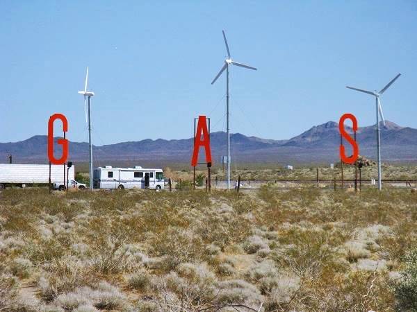
Gas sign at the Fenner service station
Continue your Road Trip
This building marks the end of your journey through Fenner. Continue your road trip by heading west along Highway 66 into the ghost town of Essex. Note that the highway towards Essex is closed.
Road Closures
Updated July 6 2023
Since 2017 Route 66 has been closed west of Fenner to Essex and from there, to Danby and to Chambless. There is complete information, with maps at the San Bernardino County Road Closed web page.
West of Chambless US66 is cut at Essex Rd. from Essex to I-40's exit 100 is open, so you can go along it, take I-40 westbound and then reach Chambless or Amboy and retake Route 66 has a partial cut on westbound lanes at Kelbaker Rd. But you can reach Chambless from Exit 78.
More sights

Lake Havasu City

Lake Havasu City, the lake, and London Bridge. Source
The resort town of Lake Havasu City on Lake Havasu has beaches along the lake's scenic shoreline, an active nightlife and the original London bridge (you can take a Tour to visit it)
The adjacent state park is open 24 hs, and there is an entrance fee. It is located on a reservoir on the Colorado River. You can hike and enjoy the riverside.
Visit the scenic shoreline with beautiful beaches, nature trails, boat ramps, and many convenient campsites.
>> Book your Hotel in Lake Havasu City
Learn more about the outdoor sites in the Havasu State Park official website.
>> Book your Hotel in Needles


Credits
Banner image: Hackberry General Store, Hackberry, Arizona by Perla Eichenblat
Jack DeVere Rittenhouse, (1946). A Guide Book to Highway 66.


