
Route 66 in Needles CA
Index to this page
About Needles, California
Facts, Trivia and useful information
Elevation 495 ft (151 m). Population 4,754 (2025).
Time zone changes as you cross into California from Arizona. Time zone: Pacific (MST): UTC minus 8 hours. Summer (DST) PDT (UTC-7).
Needles is a city, in western San Bernardino County, on the state line between Arizona and California, in the southeastern part of the latter state.
The Route 66 Motel Sign

Needles's History
The valley of the Colorado River has been inhabited for the over 10,000 years, since the end of the last Ice Age. The land is the home of the Mojave people, a name which derived from the words "aha", water, and "macave", along; that is "beside the water" (of the Colorado River).
The Native Americans lived to the south of what is now Hoover Dam beyond what is now Parks Dam.
California belonged to the Spanish colonies in America, but the desert that stood between their settlements in Los Angeles and the Colorado River deterred any attemt to establish themselves in the area.
Mexico took possession of the land after its independence from Spain in 1821 only to loose it to the U.S. after being defeated in the 1846-48 war.
The U.S. Government set out to explore the area and sent Capt. Lorenzo Sitgreaves in 1851 followed in 1853-54 by Lt. Amiel Weeks Whipple and Joseph C. Ives to survey a Pacific Railroad along the 35th parallel. (See a map of their expedition), both groups passed through what is now Needles. Lt. Edward "Ned" Fitzgerald Beale surveyed a wagon route in 1857, passing just north of Needles during his journey.
In 1859, the military established a fort on the Arizona side of the Colorado River, north of Needles: Camp Colorado, later changed to Ft. Mojave 1859 to protect the settlers heading towards California.
Only after the Civil War and the pacification of the Natives was a rail link built across the Southwestern US, and the Atlantic & Pacific Railroad -A & P (In 1897 it was absorbed by the Atchison Topeka and Santa Fe Railroad) reached the area in 1882, after crossing Arizona.
They built the first bridge across the Colorado River and established "the first Needles", as a station built on the Arizona side of the Colorado River, on Feb. 18, 1883.
The unsuitable location was soon changed for the Californian side of the river once it had been bridged and Needles was relocated on a low terrace above the Colorado River flood plain.
The Name: Needles
The town was named it after a range of volcaninc mountains with jagged needle-like pinnacles, located about 3 mi. southeast of Topock. They were known as "The Needles".
The Whipple-Ives map of 1854 shows the mountains and gives the native name for them: Asietic Häbí.

In the meantime, a rival railroad Huntington and the Southern Pacific (SP) laid a line from Barstow to Needles across the Mojave to block any advance of the A & P into California. An interchange was built at Needles linking both lines and it was the point where cargo was transfered from one line to the other.
However A&P decided to reach Los Angeles directly and started to build a line parallel to the tracks of SP. This forced their rival to negotiate the sale of their Mojave line to A&P in Oct. 1884.
The following year the Barstow - Needles Branch was linked via Cajon Pass to San Bernardino and Los Angeles, reaching the Pacific coast.
In the early 1910s when the National Old Trails Highway (N.O.T.) was being discussed Needles lobbied actively through the "Mojave County Good Roads" to have the highway built through town, and in 1912 they succeeded in their efforts and the road went into Needles and crossed the Colorado River further south, towards Topock.
The N.O.T. guide printed in the 1920s informed that Needles had a "Harvey House, hoels and garages, stores and camp grounds. Soon after, in 1926, Route 66 was aligned along the N.O.T. highway.
The town incorporated in 1913 and became a charter city in 1959.
There was a Prisoner of War camp near Needles and the Desert Training Center which was the largest in the U.S. during World War II was located nearby and trained troops for the imminent North Africa campaign.
The improvements along the Colorado River led to an inflow of tourists interested in watersports and the town thirved until bypassed by Interstate 40 in the 1970s.
Needles is still a tourism and recreation center both for the River, the game and gambling towns to the north (Laughling) and is also the eastern gateway to the Mojave National Preserve, a scenic desert National Park.

Where to Stay in Needles
There are plenty of accommodation options on Route 66 in Needles so you won't have difficulty to book your room in the city:
> > Book your Hotel in Needles
More Lodging Near Needles along Route 66
Below you will find a list of some of the towns along Route 66 east and west of Needles; click on any of the links to find your accommodation in these towns (shown from east to west):
You are so close to Las Vegas and the Grand Canyon!


>> Check out RV campground near Goffs
Weather in Needles

Location of Needles on Route 66
Needles is located at a low altitude so it has very hot summers. The area has a "Subtropical desert climate". Dry and hot, with severe thunderstorms during the summer monsoon season.
Summer average high (Jul) is 109°F (42.8°C) and the average low is 84°F (28.9°C). Winter has an average high (Jan) of 65°F (18.3°C) and an average low of 44°F (6.7°C).
Rainfall is scarce, only 4.6 in. (117 mm) per year with only 23 rainy days per year. Hardly any snow falls though, in 1949, 12.2 inches of snow fell in the area.
Tornado risk
Needles is far to the west of the Rocky Montains, there are virtually no tornadoes there. Tornado Risk: read more about Tornado Risk along Route66.
Extreme Heat and Dehydration Warning
During summer make sure you stay hydrated. The hot and dry desert climate can dehydrate you quickly. Drink plenty of water and dress for the heat.
Read more how to keep healthy in hot temperatures.
Map U.S. 66 in Needles
Read about the Topock to Barstow alignment in our dedicated webpage. Below is an interactive map of this section:
Map of this segment in Needles.
The first alignment of Route 66 in 1926
The first highway was an Auto trails one, built in the 1910s, a dirt track. Map below.

1927 Road map, western CA
Click on image to enlarge.
source

1926 Road map, western CA
Click on image to enlarge.
source
The map above (from 1926) -click on thumbnail to see large size map- shows the Highway as U.S. 60! Read why Route 66 was almost named Route 60.
This map is the first to show the alignment of a U.S. highway in Western California.
Into Needles California
The construction of I-40 and the removal of the Red Rocks Bridge across the Colorado River from Arizona, as well as the new use given to the Trails Arch Bridge as altered the original roadbed of old Route 66 in the Colorado River bridges area, you will have to cross the river into California using I-40. However, ahead you can drive along the 1930s alignment, this map map to the vantage point.
The vantage point overlooks the Colorado river and has a great view of all the bridges it takes you to the western bridgheads of all the historic bridges. To reach the vantage point leave I-40 at Exit 153 and head north along Park Moabi Rd. for 1⁄2 mi. until reaching the National Trails Highway. Take a right and follow it eastwards and then south. You will pass under I-40 and reach a parking area next to the "Welcome" Sign of Route 66 on the western tip of the now demolished "Red Rock Bridge"
This is also the starting point of Route 66 in California. One of the hottest and driest parts of the Route 66 alignment, in the Mojave Desert region, which was the toughest on both drivers and vehicles in the old-days.
We will follow the 1930s alignment northwards into Needles. Retrace your steps to Park Moabi Rd., but instead of turning keep straight ahead. The National Trails highway turns towards the SW and paving ends.
The road ahead is unpaved, it has boulders, gravel, loose sand and potholes, it is difficult, rough, with off-road sectors.
If your feel you can drive it, you can continue along this dirt, gravel and sand road. As shown in this map. It passes under I-40 (orange line in our custom map) where it runs along a dry river bed and heads west, the road curves towards the NW and runs parallel to I-40 until reaching the "Five Mile Road" at I-40s Exit 148. Here the paving begins again.
A more reasonable option, for all of us who don't fancy driving along difficult dirt roads you can take an easier route: From Park Moabi, get back on I-40 at Exit 153 and head westbound until Exit 148, leave it there (6 mi.), turn west until you meet the paved "Five Mile Road" just west of the Interstate (map with directions), the road turns north and meets U.S. 95, it continues nortwards, now as US 95, passes under I-40 (at Exit 144) and enters Needles along Broadway Street.
Route 66 in Needles
The highway crosses the town along Historic Route 66 and Needles Highway as shown in this map of US66 in Needles. However, before the freeway was built and until the early 1969s, when the overpass was built over the tracks on the west side of the town, the highway followed the alignment marked with a yellow line in our map, along Front Street with a sharp turn north along N St. There is another gap at Exit 141 where the original road was cut to make space for the Exit, this red line marks it in our custom map, a new alignment was built to link the segments.
West of Needles lie the Sacramento, Piute, and Old Woman mountains which run with a NE to SW direction, more or less parallel to the Colorado River. They had to be crossed to reach the Mojave desert and California's west coast.
The first to do so was the railway, and its engineers chose a long wide arch towards the north. The National Old Trails (N.O.T.) road followed the tracks in the early 1910s. By 1912 Needles already had gasoline and by 1924 it had a hotel and a garage. The N.O.T. guide printed in the 1920s informed that the village had "Free ice water, splendid store, camp ground garage, a cool place on Mojave Desert".
When U.S. Highway 66 was created in 1926, it was aligned along this original N.O.T. roadbed it remained on it for many years.
West of Needles
The highway left Needles along Needles Highway (see map further up), there is a gap at West Park Rd. and our custom map marks this missing segment with a turquoise line, west of this point the highway from 1926 to the 1960s is buried under the freeway so you have no option but to drive along I-40.
Western Terminus of Route 66
Terminus moved in 1964 From Santa Monica to Needles
On Aug 26, 1963 the state's Higway Commission (CHC) requested the "Elimination of Route 66... Between Jct. U.S. 95 Needles and Santa Monica" it was approved by the AASHO on Nov. 14, 1963. I-40 and I-15 replaced the former alignment between Needles and Santa Monica. At the same time the state had also requested eliminating Alt 66 from Pasadena to Los Angeles through Eagle Rock. This was also authorized. 1

End of Route 66 moved from Santa Monica to Needles, 1964. Source.
Click image to enlarge
The first segment of Route 66 to lose its certification was the one located in Los Angeles County in 1964, it was replaced by State highways Route 2 and Route 11.
The western terminus of Route 66 was "officially" moved from Santa Monica to Needles in 1964 using I-15 and I-40 all the way from San Bernardino to Needles. However, the state's Highway Commission included the alignment of Route 66 between Pasadena and Needles in its maps until 1970 as shown in the map image. Also see more maps with US 66 shields by the CHC after 1964.)

1970 Road map, western CA
Click on image to enlarge.
source
When I-40 was completed across the Bristol Mountains in 1972 (2) or 1973 (3). US 66 was decommissioned all the way from Pasadena to the "intersection of U.S. 95 near Needles, California."
There were two intersections with U.S. 95, the terminus was moved to the eastern intersection on the south side of Exit 144 of I-40 (Red arrow). See the 1970 map (click on it to enlarge it).
At the request of both California and Arizona highway departments, the American Association of State Highway and Transportation (or AASHTO) decided to move it again on June 20, 1979 from this point just south of Needles to Sanders Arizona. This marked the end of Route 66 in California. The Western Terminus of Route 66 remained in Sanders until the whole highway was eliminated in 1985.
Decertified in California and most of Arizona - 1979

Thunderstorm looms over the Mojave in California.

Route 66 Alignment near Needles
With maps and full information of the old roadway.
- Barstow to Pasadena (Next)
- Topock to Barstow (Needles')
- Kingman to Topock (Previous)
Getting to Needles
You can reach Needles driving along Historic Route 66 in Arizona and California, or I-40 from Flagstaff or Barstow, and also from Las Vegas, Nevada, by US 95.
Route 66 Sights and Attractions in Needles, California
Gateway to the Golden State
If you want to visit Las Vegas here are some tours
Sponsored content
Historic context: Classic Route 66 in Needles
Jack DeVere Rittenhouse drove along Route 66 in 1946, collecting information which he included in his book "A Guide Book to Highway 66". Which is a great reference for learning about US 66 during the post-war period. Rittenhouse mentions the following about Needles:
... hotels: California, Gateway, El Garces, Monarch; courts: Monarch, West End, Gray's, Swain's, The Palms, Havasu Court & Trailer Camp, Motor Inn Motel...Rittenhouse (1946)
He added that during the war, the "Town was jammed" but was then "returning to its leisurely way of life again. Local folk lounge in the plaza...."
Route 66 Road Trip leg across Needles
Route 66 is Broadway Street, which is Needles' main street. Coming from the west, from Topock AZ, you will begin our city tour at Needles' eastern tip, as you approach I-40's Exit 144.
We will use the ❌ symbol to mark the landmarks that have been torn down.
Trivia: Needles and Peanuts

Spike, a Peanuts character Source
As you approach the freeway, to your left is Spike Road, that meets Schulz Road 0.2 miles from the highway (Street location map). The city of Needles named these two roads to celebrate the artist Charles M. Schultz and one of his characters, Spike, who was portrayed as living here, in the desert near Needles.
Cartoonist Charles M. Schulz (1922-2000) created the comic strip Peanuts. He lived in Needles during his childhood, going to second grade there while his father was a barber (1928-30).
His character Spike was Snoopy's older brother. He was also a Beagle, though thinner than Snoopy. He appeared for the first time in the cartoon on August 4, 1974. He has a moustache, and weares a hat. Schulz said "Spike is the loner brother of Snoopy and lives out in the desert near Needles, California. Though most of his life is spent lying on rocks, talking to cacti, and writing letters to Snoopy, he has left the desert on occasion. Most of the time the reason for his outing is either a trip to look for chicks in Needles or a visit to his brother" (3).
Riverview Motel ❌

Riverview Motel in 2011, Needles US66. Click for St. view
Located at 1241 Hwy 95, on the right side of the highway the motel had a cafe, gas station and a line of cabins that ran perpendicular to the highway on the south side of the property as you can see in this aerial photo from 1947. Nowadays (St. view) only the concrete foundations of the old gas station remain and some palm trees. Below is a vintage postcard and the smaller image is a view from 2011 when the gas station was stwill standing.

Shell Station 1960s

1960s Shell, Needles CA US66. Click for St. view
Drive west into the city, after the freeway, to your left at 805 E Broadway is a 1960s Shell gas station with the typical Ranch Style, a long and low builidng with a low-sloping two-part gabled roof facing the front with a second one for the office. They had brick finish, and broad roof eaves and large transoms (the glass above the service bays) which here have been filled in). There was a brick-faced extension above the roof that displayed the Shell logo. It was in style from 1950 to 1970 and mainly in the 1960s.
Carty's Camp
After the curve, to your left, at 201 E Broadway St you can see some empty cabins, a former office building and to the left is the vacant service station quite well kept, that at one time was known as Carty's Camp. It had a flat box-shaped canopy that promoted "Lunch, hot-cold drinks and Groceries" as well as gas, lubrication and batteries.
Grapes of Wrath and Carty's Camp

Still from the Grapes of Wrath, 1940 at the Colorado River Bridge

Still from The Grapes of Wrath, 1940 at Carty's Camp. Source. Click to enlarge
The Grapes of Wrath and the Trail
The book by John Steinbeck and the movie it inspired, directed by John Ford (1940), portrayed the tragic story of an Oklahoma family, the Joads, who lost their farm during the Great Depression and migrated to California seeking new opportunities.
In this Pulitzer Prize-winning work, Steinbeck (who later won the Nobel Prize in Literature) depicts their tragic journey (along Route 66). He also coined the phrase "Mother Road", referring to U.S. 66.
>> Learn more on our Grapes of Wrath page.
The stills above are from the movie and show the Joads driving into California heading towards Needles across the old steel arch bridge, followed by Carty's Camp and the railway tracks that in those days crossed Route 66 as a spur.
William Carty and Dick Mansker opened it in 1923 (three years before Route 66 was created!). William bought out Mansker and sold it to Howard Carmody in 1940. At that time it had 28 cabins. Carmody switched from Shell to Standard Oil. But when Howard left to enlist in the US Army in 1943, it was ran by S. Stewart. After the war Howard sold it to the Ames who ran it until 1971 with a Chevron when they closed for good (4).
Carty’s Camp in a vintage 1920s photograph

Later, as Ames' Chevron
Carty’s Camp as it stands nowadays

Route 66 Motel

66 Motel nowadays, Needles. Click for St. view

66 Motel neon sign, Needles. Click for St. view

Neon sign on the corner 66 Motel. Click for St. view
Right behind Carty's, to your left, along Desnok Street, on its eastern side is the classic Route 66 motel.
It appears in the 1947 aerial photograph of the spot and it had opened after WWII. It grew at the expense of Carty's.
The restored neon sign on the corner with Route 66 is a classic 1950s -pictured.
After I-40 bypassed the town in the 1970s, guest flow decreased.
Since the 1990s it rents its apartments.
It is a typical one story motel with a rectangular plan: a central office surrounded by six units.
We wonder why was it built half a block away from the main highway?
Wheelers Flying A Service Station

Wheelers Flying A Service Station. Needles, US 66. Click for St view
Just west, to your left at 101 East Broadway is a former Flying A station, with a long canopy over two parallel pump islands supported by steel poles. The vacant sign can be seen on the western side of the property. Now it is a garage.
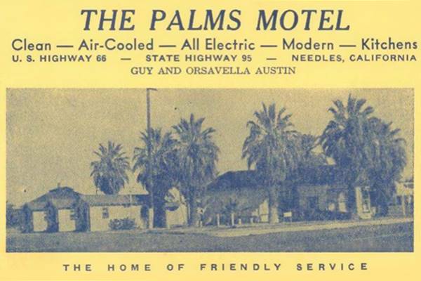
Two blocks west, there is a fork. Route 66 along Broadway takes the four-lane avenue to the left and Front Street runs parallel to the tracks to the right. Here at the fork is a classic Route 66 Motel, the old Palms Motel (now Old Trails Inn).
Palms - now Old Trails Inn
The Palms Motel was at one time a cabin court (the predecessors of modern motels) built in the 1930s. it has several separate "cabins" as units for its guests. It promoted itself as being "Clean, Air-Cooled, Modern - Reasonable... The Home of Friendly Service."
Owned by Guy and Orsavella Austin, it was -and still is- surrounded by the typical palm trees so common in Needles and they gave it its name. Later it changed hands, finally closed and in the 1990s reopened as a Bed and Breakfast changing its name to "Old Trails Inn". Below is a "Then and Now" set of pictures.
Old 1930s photo of the Palms Motel
Palms Motel nowadays:

There are some US 66 shields painted on the road by the motel.
The Palm trees
The palm trees found in Needles include date palms and especially, a local palm tree, the Neowashingonia filifera (desert fan palm or California fan palm). It is the only palm native to the Southwest of US and NW Mexico.
It can live from 80 to 250 years.
Across Broadway, to your left, at 305 E is the site of the "Women's Club of Needles" in an ancient historic cottage (St. view). The club incorporated in 1954.
Welcome to Needles Borax Wagon

Borax wagon in a 1950s postcard, Needles US66. Source
Just ahead, also on the left, the famous Borax Wagon that welcomes Needles' visitors. It was located on the triangular block between Acoma St. and Route 66. The fork onto Acoma was closed and realigned on A St.
The famous "Welcome to Needles" wagon was originally part of the decor of the El Rancho Motel on the west side of town that was torn down to make way for the freeway in the late 1950s. At that time it sported a sign that said: "El Rancho - Needles - Cooled by refrigeration - Swimming Pool - Room Phones". The cart was preserved and now it says "Needles - California". The white paint veneer has been removed, leaving a natural wood look to it (probably the boards have been replaced. Below is a "Then and Now" set of images.

A 1950s photo of the El Rancho Motel with "the" borax Wagon.
Source. Click to enlarge

Welcome Borax Wagon, Needles nowadays.
Click for St. view
This isn't a chuck wagon, it is a "borax wagon" that was used to move out the borax (a type of salt) dug up at Death Valley to the railway sidings in the 1880s. These wagons were pulled by teams of eighteen mules and two horses.

Former Swains Motel, Route 66. Source. Click to enlarge
Swains Motel ❌
On the 500s block just ahead to your left, at 511 W Broadway was the now gone "Swains Motel" it offered "32 Units with complete accommodations from singles to family connecting suites and kitchenettes. All cooled by refrigeration. Carpeted floors and tiled combinations tub and shower baths. Ample off street parking and garages. Located in downtown Needles, in the heart of the famous Colorado River Hunting and Fishing Country." It was torn down in the late 1990s.
Colorado River Ford
To your left at 539 Broadway is a large building that looks like a warehouse on the SE corner of Broadway and C St. It is the Colorado River Ford, and it was Bob Rudasill's Ford dealership with a Red Crown gasoline filling station back in the 1930s as you can see in the picture below, with its current view. The gas station later became Rudasill's Shell.

Garage on C St. and Route 66 Needles, c.1930 Source. Click to enlarge

Former Garage on US66 and C St. nowadays. Click for St. view
Service Stations - Oblong box style
Opposite the site of Swains and the Ford, on the right side of the street are two gas stations from the 1950s with flat canopies, box-shaped and two parallel pump islands to be able to attend more customers. Located at 500 and 568 W Broadway (the latter was Bill Advocate's Richfield gas station):

Old Gas station in Needles. Click for St. view

Richfield station, Needles. Click for St. view
Imperial Motor Inn
Keep on driving and on the right side of the road is a classic 1960s Motel at 644 West Broadway St. It replaced a Texaco that had stood on the corner since the 1930s and was ran by two brothers, Russel and Jack Weart. The old gas station's sign can be seen in the mid 1950s picture further down marked as (2).
It is a two story complex with stucco plastering, with an L-shaped layout. Imperial 400 was a motel chain founded in 1959 and its buildings had a characteristic "Gull Wing" shaped roof (like this motel has) with Space Age connotations. It went broke in the mid 1960s and sold out to new owners.
There are more on Route 66: Imperial 400 in Barstow,
the Imperial Winslow AZ, the Vagabond Inn Pasadena CA (former Imperial 400 Motel) and the
Imperial 400 Motel in Albuquerque, NM.
The postcard below (from the 1960s) says: "IMPERIAL 400 MOTEL On Highway 66, Downtown... 644 Broadway Needles, California Air Conditioning ... T.V.... Room Phones Kitchenettes... Heated Pool... Free Coffee Free Advance Reservations Major Credit Cards Accepted..."
Imperial 400 in a 1960s postcard


Closed since the pandemic, it retains its original structure but without the red and blue colored bands on the building.
Imperial '400' Motels and Route 66
Learn all about these Space Age motels along U.S. 66.
> > Read more: Visit our Imperial "400" Motels on Route 66 webpage.
The building on the eastern side of the motel, with a slanting roof was built in 1959 to house Cubs Liquor shop, it was designed by Pierce Woodman of Ontario (5).
Desert Inn Motel
Opposite the Imperial 400, on the SE corner at 625 W Broadway St. is the former "Desert Inn Motel." Now it became the "Riverstone Apartments Senior", an apartments building. It has preserved its original appearance, including the trapezoidal-shaped base of the old corner signpost on the facade of the office on the corner. You can see it in the mid 1950s image further down, marked (1); at that time it was owned by Winnie Schaffer.
Desert Inn Motel in an old postcard

Former Desert Inn Motel nowadays:

The next block (600s) has undergone many changes over the years with motels and gas stations being torn down. Below is the story and the buildings that have survived and vanished. The image below looks westwards along Route 66 (Broadway) from D Street.

Click image to enlarge
The image above -click on it to enlarge it- shows the Desert Inn to the left with its neon sign (1) and the Texaco opposite, where the Imperial 400 now stands (2).
Irene's Hamburger Hut

Irene's Burger hut nowadays. Click for St. view
To the left, on the western side of D Street is a Drive In. It was Irene's Original Burger Hut (4). It is still standing as you can see in the St. view. Below is a lae 1950s picture. Lee Astor McCary (1916-1987) opened it in the 1950s and he named it after his wife Irene Evelyn McDaniel McCary (1923-2001). It has been closed for some time.

McConnell Motors Chevrolet

McConnells nowadays, Needles CA. Click for St. view
Opposite marked with a (3) on the NW corner is the building built in the 1940s to house R. J. McConnell's Chevrolet dealership. Later it became McConnell Motors Buick. At the time that picture was taken it was the Bank of America. Later it was a Drug Store and a Store (Deco Foods). Below is a view of it as a dealership, it includes the Texaco (2) and more buildings that we will describe below.


Old Trails Garage c.1930s. Source
Old Trails Garage ❌
Marked with a (5) this garage had a false front parapet with a stepped shape and its name written across it. The garage was endorsed by the ACSC National Olt Trails monthly magazine as trustworthy (6).
John Lorimer (1861-1935) migrated from Scotland to America and reached Needles from Chicago in the early 1900s. He was Needles' first Mayo. He bought the Old Trailer Garage in 1912 with his partner George. It was the first fully equipped shop in the Mojave. His son Robert Burns “Bob” Lorimer (1889-1958) ran it until his death (7). Notice the pump on the sidewalk in the image.

Now the lot is empty (St. view).
Overland Motel ❌

Overland Motel (gone) 1964. Needles Route 66. Source
Click to enlarge
To your right, on the north side of Broadway at 712 W Broadway St. was the Overland Motel, marked with a (6). It was torn down in the mid 2010s. The place is now an empty lot (current St. view).
It postcard below tells us: "OVERLAND MOTEL 712 Broadway On U.S. 66 in center of Needles 40 units beautifully furnished in Italian Provincial...
Family Suites... King Size Beds... Individual Air Conditioning and Heating... Tub and Shower... Swimming Pool... Television. COFFEE SHOP... DINING ROOM..." See its 2011 St. view while it was still standing.
Next to it was the also razed Sambo's Restaurant, part of a chain named after the its founders Sam Battistone Sr. and Newell Bohnett, it operated between 1957 and 1981.
Claypool & Co.
Opposite the Overland and almost adjacent to the Old Trails garage, to your left, at 725 W Broadway St. is the Claypool store, we marked it with an (8)

Claypool Store nowadays. Click for St. view
The store on the southeastern corner of E Street began as a hardware store in the early 1900s. This building was built in Art Decó and opened in 1930 just as the Great Depression was starting. During the 1950s and 60s it's classic facade was covered over to make it more hip as you can see in the image below.
It finally closed in the 1990s but was restored and it now houses the Palo Verde College.
Art Deco Style
Art Deco style flourished between both World Wars (1914 - 1940). It was a symbol of wealth, luxury and elegance that adopted symmetry, rich colors and bold rectilinear geometric shapes to exalt the technological progress of the early twentieth century. In this store, the chevrons that decorate the facade, the angled entrances, steel grating over the upper windows, the rhomboids set in triangles above the first floor windows are typical of Art Deco style.
Gas Stations Corner ❌
Opposite the store and next to the Overland, on the NE corner of E street was a service station that we marked with a (7). It began as a Chevron, of Standard Stations Inc. in the 1930s, and became a Union 76 in the 1960s. Now the lot is vacant.
Gateway Hotel ❌

Needles Gateway Hotel, 1922. Source. Click to enlarge
One block north along E Street takes you to Front Street, that ran beside the tracks. The Gateway Hotel mentioned in 1946 by Rittenhouse stood on the 700s block, to your right. It had 50 rooms and five-stories. The tallest building in town. Surrounded by cafes, stores, and close to the railroad depot. The picture depicts it in 1922. The blocks have been greatly altered, all those old buildings are long gone.
Needles Theater
Back on Broadway, the 800s block has only one surviving landmark on its SE corner with F Street, the movie theater built by the Masonic Order in 1929 who occupied the second floor, it opened in 1930 and had a capacity for 700 spectators. Its roof caught fire in 1992. The order donated it to the city who partially restored it. Below is a "Then and Now" set of pictures of it.

The Theater in 1941 Route 66. Source. Click to enlarge

Needles theater nowadays. Click for St. view
California Hotel ❌
Across F Street, on the SW corner of Broadway once stood the California Hotel, a two-story brick building that was "aircooled" and had 50 rooms. It was mentioned by the 1934 ACSC National Old Trail Road guide and endorsed by their magazine as a good spot to stay at. Rittenhouse mentioned it in 1946. A fire razed in around 1980 and the city tore it down.

The image above looks along F St. southwards, the California Hotel is upper right, with Broadway (US 66) running in front of it from left to right. Beyond is Robinson's motel. The Shell station sign opposite the California can be seen. Closer is the Monarch Hotel and Quinn St. forking to the right.
Robinson's Motel
Still standing one block south of Route 66 along F Street, with its neon sign on the corner beckoning those driving along the Mother Road. 1953 postcard describes it as follows: "223 F. St. - 1 Block So. of U. S. 66... A fullty modern, carpeted motel... Private Garage. Cooled by Refrigeration... away from traffic." Across from the motel at 221 F St. was Robinson's Motel Garage, now River Valley airconditioning.

Robinson's Motel, Needles in 1953. Source. Click to enlarge

Robinson's Apts. nowadays. Click for St. view
Monarch Hotel
Heading north, opposite the California Hotel, on the NW corner of Broadway and F St. stood a Shell station ❌ and adjacent to it, facing both F and Quinn Streets was the Monarch Hotel, with 35 rooms in a two-story building. Rittenhouse mentioned it back in 1946.
Same view nowadays (Shell and California hotel gone)

Opposite the Monarch Hotel, across Santa Fe plaza, a square with palm trees that faces Quinn St. you will see the Historic El Garces Hotel.
El Garces Hotel
Listed in the National Register of Historic Places.

El Garces c.1930s. Source. Click to enlarge

El Garces Hotel nowadays, Needles CA. Click image for St. view
Also mentioned by Rittenhouse in 1946. Located at 950 Front St. After the original railway station burned down in 1906, the AT & SF railway built a new one that included a hotel and retaurant.
It is a two story building styled like a Greek temple style, with Tuscan columns. It opened in 1908. It was named after a Spanish Missionary who explored the region in 1771-74, Francisco Garcés, the first European to cross the Mojave Desert.
It was ran by the Fred Harvey Company, and thus was a "Harvey House", an expensive hotel favored by railroad passengers and the motorists until the Post-War period.
The hotel closed in 1949 and became the railway offices in Needles. It was abandoned in 1988 but a local group (Friends of El Garces) rescued it in 1999, had it listed as a Historic Place (2002) and managed to get a $10 million renovation work started.
Needles Regional Museum
Facing the Santa Fe plaza , just down the block from the former Monarch, at 929 Front St. is the local museum. It was the building of JC Penney's store which after 1995 became the site of the museum. Plenty of memorabilia and artifacts from Needles' past. Open Mon. through Sat., 9AM - 2PM from Sept. through May.
Continuing west along Broadway, head back to the Theater and on the 900s block, to your right there are three buildings from the Golden days of Route 66:
Shell Service Station
On the corner at 900 W Broadway is the old Shell station. It has been greatly altered, but you can see it was a gas station (St. view). It is pictured below in the 1960s view (click image to enlarge it).

City Center, Shell and Red Dog c.1960s. Source. Click to enlarge

City Center motel nowadays US66 Needles. Click for St. view
City Center Motel
At 910 W Broadway is a gable roofed building resembling a cottage. It was a ten room motel in the 1960s as you can see in the picture above (it also shows the Shell, and the Standard station on the NE corner of Broadway and F St.) its sign reads "Motel".
Shamrock Cafe - Red Dog

1950s Shamrock Cafe Needles CA. Source. Click to enlarge
At 914 W Broadway, the building is unchanged, stone veneer on the lower part of the front wall, two windows (now walled in) and the stepped parapet. It was the Shamrock Cafe in the earlhy 1950s when R.J. McConnell built it and his wife Sue ran it. The place closed in 1964 and reopened later as a bar that changed names over the years: Red Dog (as you can see in the mid 1960s picture further up), Iron Horse, and again now as the Red Dog. This is its St. view.
There was a Texaco on the corner next to the cafe. And on the corner across G St. is the Welcome to Needles monument pictured below.

Needles Monument on US66. Click for St. view

Needles USGS map, 1952. Route 66 alignment. Click for St. view
As the USGS map above shows, Route 66 took a right here on G Street and passing by the west wing of El Garces Hotel, turned west again along Front Street and crossed the railroad with a grade crossing at N Street. See it also in this 1947 aerial photo.
Later the highway was realigned along Broadway when the railroad viaduct was built in 1965 to accommodate the ramp and curve that couldn't be built safely using Front St. There are no existing structures along Front or Broadway east of the viaduct.
The Broadway Motel stood on this south side (left) of the block between G and H Streets, it was a cottage style building owned by Bill and Phyllis Cannon (8).

Current view, Sage Motel, Needles CA. Click for St. view
The Sage Motel
The highway crosses the tracks using the overpass and at the foot of the viaduct, to your right is an old motel:
At 1624 N St. Built in 1955, it has a "L-shape" design and a one-story building. It still has the original faded and peeling neon sign.
The Sage Motel in an old postcard

West End Motel & Cafe ❌

West End Motel and Cafe, Route 66. Source. Click to enlarge
Opposite the Sage, on the SW corner of Route 66 and Market St. at 1627 W Broadway to your left was the West End Cafe, owned by Dollie and Bill Glabb. Later it became the West End Truck Stop it sold Wilshire Gas.
Traveler's Motel ❌

1950s Travelers Motel Ad. Needles. Source. Click to enlarge
Diagonally opposite the West End, on the NE corner of Market and W Broadway was this L-shaped motel, ran by the Binks it lasted into the early 1990s. Now there is an oil change business on the spot. The motel was built in the 1950s on what used to be "Needles Camp Grounds."
On the corner ahead the highway turned left along what is now Needles Highway. Here, to your left, on the SE corner was a classic Tourist Camp. You can see it in the upper part of the 1960s black and white aerial photograph further down.
Needles Camp Grounds ❌

West end of Needles c.1960s. Source.
Click image to enlarge
The Needle Camp Grounds had "Clean Cottages" and a Texaco gas station it was owned and ran by Austin O. Fahey it offered groceries, ice and cold drinks. The cabins and campground extended south along the eastern side of N St. Formerly it had beenknown as "West Stide Camp Ground." The highway curves in front of it to the west at the modern junction of N St. and Needles Hwy., in those times there were plenty of salt cedar trees. Below is a "Then and Now" set of pictures. And you can see it on the lower right side of the crossroads in this 1947 aerial photograph with the corner building, cabins and trees. The black and white aerial picture further down shows the curve at N and Needles Hwy in the 1960s before I-40 cut across this area. You can still see some cabins in the campground (upper right side of the image).

1930s Needles Camp Grounds. Needles Source. Click to enlarge

Needles Camp Grounds site nowadays. Click for St. view
McConnell Shell and Foster's Freeze ❌
Across from the campgrounds, on the SW corner there is now a place of worship, Kingdom Hall (St. view). It was the site of McConnell Motors Shell Station and Cafe that were ran by the Booths and you can see it on the corner in the 1960s aerial view further up. It had a Shell gas station and the cafe was behind. The cafe later brecame Loma's Cafe with the famous "mile-high" meringue. Both buildings have gone. But below are two vintage photographs of them (compare them with the aerial picture).
Next to it, on the south side was Foster's Freeze (now the church's parking area) a drive in popular in the late 1950s.

Route 66. Source. Click to enlarge

Fosters, c.1950s, Needles Route 66. Source. Click to enlarge
Continue west as the highway turns sharply towards the left along Needles Hwy. To your left is a 1950s motel:
River Valley Inn

River Valley Inn nowadays. Click for St. view
Beside the Jehova Witnesses church, at 1707 Needles Hwy. Its postcard when it was the River Valley Motor Lodge tells us it had "Heated pool, Free Coffee & Ice. One mile to Colorado River and Marina...." It is still open as a motel. You can see it in the 1960s aerial view further up, with two long parallel sets of units just after the curve, to the right.


Adobe Motel. Source
Adobe Motel ❌
The now gone Adobe Motel (St. view of the vacant lot) stood opposite, on the north side of the highway, and you can see its dual gable roof cabins aligned along O St. in the 1960s aerial view. It was owned and ran by Ehrma Lee Watkins until it closed in the 1980s (9).
El Rancho Motel ❌
Next to the Valley Inn, on the south side of the highway, the El Rancho was to your left. It had 24 units wth a L-shaped layout, central pool by two palm trees and the neon sign. The aerial picture from the 1960s shows it to the right just beyond the curve.

At one time it had a wagon as part of its signage, it was moved after the motel closed to the eastern side of the city.
Del Rhea Lodge

Del Rhea motel nowadays US66. Click for St. view
Arcoss the street, opposite El Rancho, on the left side of KFC is a vacant motel, formerly the Del Rhea and now an apartment complex. Their 1950s poscard places it on "U.S. 66 and 95. West end, Needles Calif" and announced it offered "A very lovely, "roomy", modernistingly furnished Motor Hotel, cooled by Refrigeration... Filtered Swimmins Pool. Owner Operated." Its pool has been filled in.

Two motels stand on the north side of the road, just before the freeway:
Needles Travelodge

Best Motel, closed, 2022. Click for St. view
The Travelodge stood beside the Del Rhea at 1900 Needles Highway it became the "Best Motel" but is now vacant. It retained its original layout and has kept its neon sign, adapting it to its new name. Its postcard states: "Restaurant & Cocktail lounge on premises - 4 blocks from Colorado River and Golf Course." It appears in the 1960 aerial view.

Royal Inn

Desert Mirage (old Royal Inn), closed. Click for St. view
Right beside the freeway at 1910 Needles Hwy. It was built in the mid 1960s as the Royal Inn, whose postcard proclaimed "Always be treated like a king" and which had "46 new modern units-luxuriously furnished". It is basically unchanged however, its classic neon sign has been replaced by a bland one. It later became the now vacant "Desert Mirage Inn & Suites."

Union 76 - Minute Man Service

Union 76 service station, US66 Needles. Click for St. view
Pass under I-40 and you will see a classic service station to your left on R St. and Route 66, the Minute Man Service that at one time was a Union 76. It appears in the 1960 aerial photograp (lower right -at that time there was no freeway cutting across Route 66). It has a very large canopy a long truncated triangle with a definite Space Age Googie style typical of the late 1950s and early 1960s.
American pop artist Edward Ruscha lived in Los Angeles and drove frequently along Route 66 (he was captivated by it). His 1963 book Twentysix Gasoline Stations depicts black and white pictures of 26 gasoline stations along Route 66 with the location and gas brand sold. One of them is this Union station in Needles photographed in October 1962 shown below:
Edward Ruscha's Union 76, 1963© 1962 From Twentysix Gasoline Stations, Union, Needles")
Union Oil Co. of California adopted the number 76 as its logo back in 1931, it paid homage to the "Spirit of 1776" and they complemented it with their "Minute Man Service" (did you know that the colonial militia that fought in the American Revolutionary war, known as Minutemen, got their name because they could be ready at a minute's notice?).
Former Wilshire Gas station

Former Wilshire gas station, Needles. Click for St. view
Across R. St., following the Minuteman, to your left is another Service Station with a modernistic canopy, streamlined and held up with two poles that pierce it. Two steel cables hold it up like a modernistic sculpture. This was the style used by Wilshire gasoline, later part of Gulf. Built in the 1960s, see the San Bernardino Wilshire on US 66 in San Bernardino CA and the Santa Monica Wilshire in Santa Monica CA with this same canopy style.
Kiva Motel
Across US 66, to your right is this classic motel, named after a Pueblo Indian word for "room". Now it is the Budget Inn


Le Brun Motel ❌
2109 W Broadway. Facing the Kiva, on the south (left) side of US66 was the former Le Brun Motel torn down in 2017 this is a view of its neon sign and the property shortly before it was razed.

Le Brun Motel (gone). Click for St. view

Neon sign of the Le Brun Motel, US66 Needles. Click for St. view
Dawe's Chevron, Needles CA. Source. Click to enlarge
Dawe's Chevron ❌
Route 66 crosses the wash and continues west. Here to your left, after the bridge at the wash was Dawe's Chevron (gone) followed by an A &W stand (gone).
Texaco gas station
Just ahead before the curve, to your left is a restored Texaco gas station. It was owned by Bea and Harold Stout, and later it became a Mobil till it closed in the 1970s. It is a simple service station with one service bay, office and a flat canopy, neatly restored. Below are a set of "Then and Now" pictures:

The old Stout Texaco restored:

The right side of the highway has undergone many changes over the years.

Relax Inn in 2016. Needles US66. Click for St. view
Nomad Motel (later Relax Inn) ❌
On the corner of Route 66 with T St., to your right (2208 W Broadway) was the Nomad motel, there were others along Route 66 (in Ash Fork, and Seligman AZ), the Middle Eastern domes fell out of favor after the Iranian Hostage crisis in 1979 so they were removed. The place became the Relax Inn and has been partly torn down. The office has survived, with the arches facing Route 66 and its triangular shape (view in 2021).

Ranch House Restaurant ❌
Long before the Nomad was built, the Ranch House restaurant was located here exactly opposite Stout's Texaco. It was ran by Stringham, and also served as a truck stop.

Ranch House Truck Stop 1940s. Source. Click to enlarge

Blakely's gas station, Needles. Source. Click to enlarge
Blakely's Gas ❌
Across the narrow dirt road to the west, where the Denny's was later built, stood the Blakely Service Station owned by Joe McIntyre, right on the curve. The image above shows it, and Stout's Texaco in the 1955 flash flood. Notice the rocket on Blakely's neon sign.
Monroe and Vincent Blakely opened their first station in Gilbert AZ in the mid 1930s and ended up with 80 of them. They sold the chain to Gulf Oil in 1964.
Denny’s Diner
The former Denny's Diner was built on the site in the mid 1960s; it has the classic "Boomerang Roof", a design from the early 1960s by Armet & Davis.
German filmmaker Wim Wenders photographed it back in 1983 when he was touring the Southwest seeking locations for his classic movie "Paris, Texas". He published the photos in a book "Written in the West" with fascinating images.

A 1983 photo by Wim Wenders

Dennys nowadays. Click for St. view
Red Roof Inn (former Hyatt Chalet)
The highway curves right around Denny's and heads north, to your right, at 2306 West Broadway St. is a mid 1960s motel. It is still operating and is now the Red Roof Inn.
This chalet-style with a steep gable roof is a design that dates back to 1960 when Hyatt planned to build some 200 similar motels by 1966. They were part of Hyatt Lodges, a new division within the company.

Vintage postcard of Hyatt Lodge, Needles. Source. Click to enlarge

Old Chalet Hyatt Lodge nowadays. Click for St. view
At 2402 W Broadway, across Race St. was the Whiting Brothers gas station ❌; it was torn down in the early 1990s (1969 aerial photo).
Route 66 continues towards the north here it has a slight gap due to the freeway, and it curves at Exit 141; this red line marks the old alignment in our custom map, a new alignment was built to link the segments.
Stuckey's ❌

Stuckey's on Route 66, Needles CA. Source. Click to enlarge
On the north side of I-40 at the junction of the old Route 66 alignment with the new one, there was a bowling alley in the 1960s to your right, on the eastern side of the highway. One thousand feet north at the concrete ford, to your left along a now empty stretch of highway is the site of Needles Stuckey's that opened in 1964. Soon bypassed by the freeway. The concrete islands that supported its butterfly canopies are still there in the sand (view). The 66 Truck Stop further west can be seen in the image.
Lad Motel (Fender's)

Fender's neon sign. Route 66. Source. Click to enlarge
Ahead at 3396 Needles Hwy, to your right, is "The only motel on the River" (on the Colorado River) in Needles. Now it is Fender's River Road Resort, but its original name was Lad Motel and you can see it in a 1962 advertisement below and the original sign has been restored.

66 Truck Service Cafe ❌

66 Truck Stop, Route 66. Source. Click to enlarge
Ahead, is the "Y" where Route 66 forks to the left to head west and Needles Highway keeps north following the Colorado River. Here to the left are the concrete foundations of the buildings of the 66 Truck Stop. Lomas' restaurant was also at the stop.
This satellite view shows the remains of the buildings.
Continue your Road Trip
This fork in the highway marks the end of your journey through Needless. Continue your road trip by heading west along Highway 66 into the ghost town of Goffs.
Tours and Outdoors
Mystic Maze
Also known as "Topock Maze"-
Listed in the National Register of Historic Places.

The stone patterns at Mystic Maze. Source
South of Needles, at I-40s's Exit 153, head to the south side of the highway, and drive east for 1.1 miles. The maze is 100 yards to the north, behind a fence. Map with Directions.
It is an intriguing site: a "geoglyph" (a large design made on the ground with rocks or stones) built by the natives some 600 years ago.
It consists of winding parallel patterns, following the countour of the hill, and cover about 15 acres of desert (6 ha.); in the past it was larger but was destroyed in part by the railway building,
It was created by removing the stones with a jet black varnish, revealing the lighter colored soil below as you can see in this Satellite view.
It had a religious significance for the local Natives but what it meant is a mystery, even to the modern Mojave Indians.
It is a National Wildlife Refuge Systems Archaeological site and despite being similar to agricultural terraces, it was not used for growing crops.
Mojave National Preserve

Kelso Dunes in Mohave Preserve CA. source
The Mojave National Preserve protects almost 1.6 million acres of desert habitat; it is a scenic National Park located just west of Needles, between I-40, I-15 and the California-Nevada state line.
Observe wildlife like the Desert Tortoise or Bighorn Sheep. Visit the "Hole in the Wall" area, the Cinder Cones, Cima Dome and Kelso Dunes.
Read more at the National Parks website.
More sights

Lake Havasu City

Lake Havasu City, the lake, and London Bridge. Source
The resort town of Lake Havasu City on Lake Havasu has beaches along the lake's scenic shoreline, an active nightlife and the original London bridge (you can take a Tour to visit it)
The adjacent state park is open 24 hs, and there is an entrance fee. It is located on a reservoir on the Colorado River. You can hike and enjoy the riverside.
Visit the scenic shoreline with beautiful beaches, nature trails, boat ramps, and many convenient campsites.
>> Book your Hotel in Lake Havasu City
Learn more about the outdoor sites in the Havasu State Park official website.
>> Book your Hotel in Needles
Credits
Banner image: Hackberry General Store, Hackberry, Arizona by Perla Eichenblat
Jack DeVere Rittenhouse, (1946). A Guide Book to Highway 66.
1. Route Numbering Archive AASHTO file Other (49).PDF, search terms: Route Number: 66.