Route 66 in Goffs CA
Index to this page
About Goffs
Facts, Trivia and useful information
Elevation 2,595 ft (791 m). Population n⁄ (2025).
Time zone changes as you cross the Arizona - California State Line. Time zone: Pacific (MST): UTC minus 8 hours. Summer (DST) PDT (UTC-7).
Goffs is a ghost town in western San Bernardino County, in southeastern California.
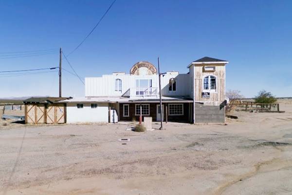
View of the Goffs General Store
History of Goffs
Check our Needles page for the early history of the area.
The Huntington and the Southern Pacific (SP) laid a line from Barstow to Needles across the Mojave in 1883, passing through what would later become Goffs station. The following year they were forced to sell it to the Atlantic and Pacific Railroad (which later became the AT & Santa Fe Railway).
The station was founded in 1893 but it was originally named Blake after Isaac Blake, who built the "Nevada Southern Railway" from there, northwards.
Nevada Southern Railway Co.
This railroad was incorporated in 1892 and laid its tracks north, from Goffs (which was named "Blake") to a ranch area known as Barnwell and renamed Manvel (after the owner of the company) it carried goods to the mining districts of Goodsprings, Ivanpah and Eldorado.
At Goffs it linked with the AT & Santa Fe Railway. In 1895 it changed its name to the "California Eastern Railway", extending into Searchlight, NV. In 1911 it was acquired by the AT & SF. only to be abandoned in the 1920s.
In 1902 the station was renamed Goffs, an odd name for which there is only one explanation (which is applicable to all the stations between Amboy and Needles:
The AT &SF named these stations following an alphabetical order - there were exceptions: the small sidings between those stations, shown below between brackets:
Amboy, (Saltus), (Altura), Bristol, Cadiz, (Siam), Danby, (Arimo), Essex, Fenner, (Piute), Goffs, Homer, (Bannock), Ibis, (Klinefelter), Java, Khartoum.
The name: Goffs
Goff derives from Welsh, the nickname for a red-haired person (Gough). Also, in English (of Cornish and Breton origin) it was applied to the horse-smith. In Ireland it can be found as McGoff.
Where did it get the final "s" from? Perhaps from the possessive form Goff's.
The station was located just west of the railroad divide (2,584 ft), on the northern tip of the Piute Mountains and the southern mouth of Lanfair Valley. It had a deep well providing water for the steam engines. In 1915 it was described as "... an old settlement supported mainly by gold, silver and copper mines in the mountains."
By that time, the National Old Trails Highway (N.O.T.) had been built from Barstow to Needles and went through Goffs. Route 66 was aligned along the N.O.T. highway in 1926, but the village would remain on the Mother Road for a short period of time: in 1931 US 66 was realigned further south, bypassing the town for ever.

Where to Stay: Find your Hotel near Goffs
There are plenty of accommodation options on Route 66 in neighboring Needles and Barstow so you won't have difficulty to book your room there:
> > Book your Hotel in Needles or Barstow
More Lodging Near Goffs along Route 66
Below you will find a list of some of the towns along Route 66 east and west of Goffs; click on any of the links to find your accommodation in these towns (shown from east to west):
You are so close to Las Vegas and the Grand Canyon!
>> Check out RV campground near Goffs
The weather in Goffs
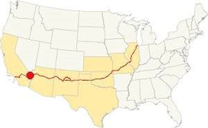
Location of Goffs on Route 66
Not much rain falls in Goffs, only 6.8 in. (173 mm) per year with only 25 rainy days per year with April to July being the driest period. Snow is very uncommon.
Goffs is at a reasonable altitude so it is not so hot in summer as the lower areas (like Needles); nevertheless, it has very hot summers. The area has a "Subtropical desert climate". Dry and hot, with thunderstorms during the summer monsoon season.
Summer average high (Jul) 109.4°F (43°C) and average low 78.8°F (26°C). During winter, the average high (Jan) is 68°F (20°C) and the average low 42.8°F (6°C).
Tornado risk
Goffs is well beyond the Rocky Montains so there are virtually no tornadoes in the area.
Tornado Risk: read more about Tornado Risk along Route66.
Extreme Heat and Dehydration Warning
During summer make sure you stay hydrated. The hot and dry desert climate can dehydrate you quickly. Drink plenty of water and dress for the heat.
Read more how to keep healthy in hot temperatures.
Map U.S. 66 in Goffs
Read about the Topock to Barstow alignment in our dedicated webpage. Below is an interactive map of this section:
Map of this segment in Goffs.
The first alignment of Route 66 in 1926
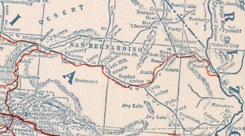
The first highway was an Auto Trails one, built in the 1910s, a dirt track. Map below. Notice it says "Blake (Goffs Sta.)"
1927 Road map, western CA
Click on image to enlarge.
source
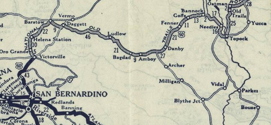
1926 Road map, western CA
Click on image to enlarge.
source
The map above (from 1926) -click on thumbnail to see large size map- shows the Highway as U.S. 60! Read why Route 66 was almost named Route 60.
This map is the first to show the alignment of a U.S. highway in Western California.
West of Needles to Goffs
West of Needles lie the Sacramento, Piute, and Old Woman mountains, which run with a NE to SW direction, more or less parallel to the Colorado River. They had to be crossed to reach the Mojave desert and California's west coast.
The first to do so was the railway, and its engineers chose a long wide arch towards the north. The National Old Trails (N.O.T.) road followed the tracks in the early 1910s. By 1912 Needles already had gasoline and by 1924 it had a hotel and a garage. The N.O.T. guide printed in the 1920s informed that the village had "Free ice water, splendid store, camp ground garage, a cool place on Mojave Desert".
When U.S. Highway 66 was created in 1926, it was aligned along this original N.O.T. roadbed it remained on it for many years.
The highway left Needles along Needles Highway (see map further up), there is a gap at West Park Rd. and our custom map marks this missing segment with a turquoise line, west of this point the highway from 1926 to the 1960s is buried under the freeway so you have no option but to drive along I-40.
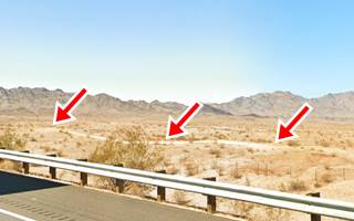
Further north the highway and railroad curve west and I-40 crosses the tracks. Here the 1926-50s alignment splits from the freeway; we marked this old roadbed with a violet line in our custom map. The image shows (red arrows) the old roadbed here.
There is a fork just ahead. The 1926-31 highway turns north towards Las Vegas heading to Homer and Goffs. The map shows the gap in magenta. To drive this section from Needles to Goff, you will have to use I-40 and US 95, this is the 1926-1931 Route 66 map from Needles to Goffs.
From Goffs, the highway curved south to Fenner (map with directions).
The 1931 alignment of Route 66
In the early 1930s, Route 66 was realigned, shortening it and paving it, improving bridges and shoulders. The Needles to Essex section was no exception.
A shorter alignment, six miles south of Goffs, was built across the Piute Mountains. It had a steeper grade than the older road, but cut off 8 miles from the original 1926 alignment.
The new road opened on Dec. 4, 1931, and Goffs was bypassed.
Route 66 Alignment near Goffs
With maps and full information of the old roadway.
- Barstow to Pasadena (Next)
- Topock to Barstow (Goffs')
- Kingman to Topock (Previous)
Getting to Goffs
You can reach the town driving along old Route 66 or I-40 at Exit 107, and also from Las Vegas, Nevada, along US 95.
What to see in Goffs, California
A Fading Village, the Desert Tortoise Capital of the World
Historic context, the classic Route 66 in Goffs
When Jack DeVere Rittenhouse drove along Route 66 in 1946, collecting information which he included in "Guide Book to Highway 66", it was already 15 years since Goffs had been bypassed when Route 66 was realigned six miles south of the village. We have no reference from Rittenhouse regarding Goffs, as he writes about the later, post-1931, road from Needles to Essex.
Almost a Ghost town on Old Route 66
Desert Tortoise
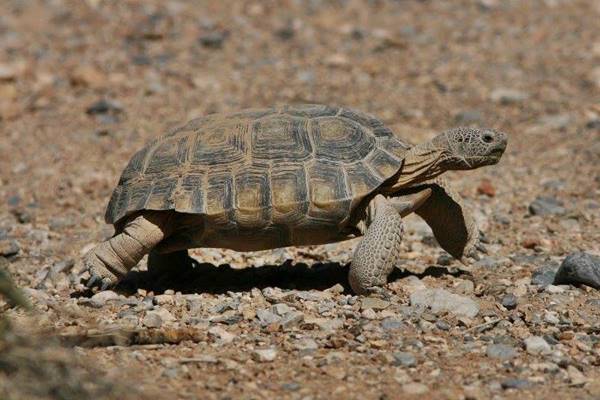
The desert tortoise (Gopherus agassizii) is a rugged denizen of the desert. It digs underground burrows 3 to 6 ft. deep (90 - 180cm) to escape the extreme heat and cold of the Mojave desert.
They hibernate underground from Nov. to Feb. and resurface in spring (Mar. to May) to mate and enjoy the summer and fall rainy season.
They are herbivores and absorb water from the plants they eat.
Important: Watch out for tortoises on roads
They may drink water in puddles on roads or shoulders and can be hit by cars and killed. Drive with caution and watch for tortoises on the road or near it.
They are listed as threatened by the federal government.
Photograph them from a distance, don't touch them or disturb them. They are a protected species. If frightened, they may empty their storage bladders and lose precious water, risking death.
A Desert Tortoise in the Mojave
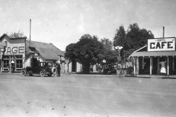
The original 1926 alignment was a dirt surfaced road, in 1926, the new alignment that ran further south was paved. We have a photograph of Goffs in the 1920s or early 1930s showing what it was like at that time, notice the car, the gas pump at the Garage (left) and the Cafe (right):
But little remains of those days, some landmarks have survived, restored or rebuilt, to rescue the past, others have burned down.
As you approach Goffs from the east, coming from Needles just before you cross the railroad is the site of the old store.
Goffs General Store ❌
The red cross symbol marks that it has gone, in this case due to a blaze.
It was the town's largest building but was in a sad state of disrepair. It was completely refurbished in 2000, but a few years later it was abandoned and gradually got worse. The march of time is a relentless and unforgiving one. And on June 8, 2021 it was consumed by a fire that destroyed it.
The building pictured at the top of this page (in 2009), was built in 1946. Sadly, another 66 "monument" has gone. At one time it had a gas station, a bar, and a dance hall. It was ran by the Swain family from the 1950s onwards until it closed in the 2000s.
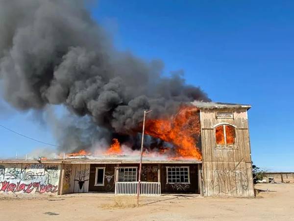
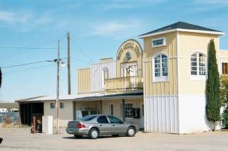
The store in 2000, in fair shape. Source
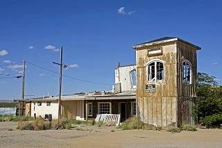
The store in ruins. Source. Click to enlarge
Drive across the railroad tracks, and just ahead after the highway turns left, take a right onto Lanfair Rd. to visit two landmarks of old Goffs:
Goffs Schoolhouse
National Register of Historic Places
37198 Lanfair Rd., Goffs. Two hundred years west of Old 66. To your left.
As the town grew and the mines expanded, more families moved to Goffs, and their children needed a school. This led to the establishment of a school in town in 1911 in rented quarters.
Three years later, the Shoolhouse building at Goffs was built by San Bernardino County. It opened in 1914. It is a one-room, one-floor building designed in Mission Revival style by architect Anthony Beimer.It also served as the local library and the community center.
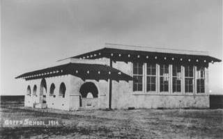
A 1914 photo of Goffs School. Source. Click to enlarge
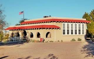
The restored Goffs School, nowadays. Source. Click to enlarge
It was a fairly large single-classroom (800 sq. ft. - 74 m2) with one teacher instructing children until 8th grade (they had to go to Needles for higher education).
During the depression, as mining declined and the town was bypassed by the paved alignment of US 66, the population fell and the Goffs School District merged with the one in Needles. The school closed for good in 1937.
World War II gave it a new use as a canteen for the troops training in the Desert Training Center.
After becoming private property and falling into disrepair, the Mojave Desert Heritage and Cultural Association (MDHCA) rebuilt the school and has turned it into a museum (do drop by and visit it), and the local cultural center.
Don't miss the cottonwood trees on the southwestern side of the building, carefully planted and watered in the desert.
Camp Goffs
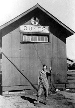
Camp Goffs during WWII. Source
There is a marker in Goffs with a plaque mentioning the fact that Goffs was the Headquarters of the 7th Infantry Division in 1942, and later fought in the Pacific Theatre against Japan.
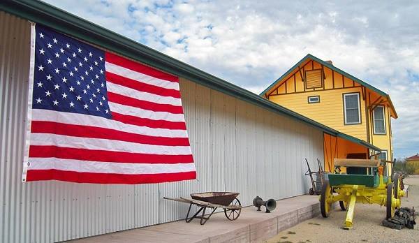
Replica of Goffs' station (Depot)
Ahed, just west of the school is The Mojave Desert Archives Library. It is housed in a building that is a replica of the Goffs Santa Fe Railway Depot, built in 1902 and demolished in 1956.
It houses the archives of the Association and was dedicated in 2008.
Replica of the 1902-1956 Goffs Depot
Continue your Road Trip
This building marks the end of your journey through Goffs. Continue your road trip by heading west along Highway 66 into the ghost town of Fenner.
Outdoors, National and State Parks
Mojave National Preserve
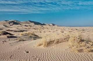
Kelso Dunes in Mohave Preserve CA. source
The Mojave National Preserve protects almost 1.6 million acres of desert habitat; it is a scenic National Park located just west of Needles, between I-40, I-15 and the California-Nevada state line.
Observe wildlife like the Desert Tortoise or Bighorn Sheep. Visit the "Hole in the Wall" area, the Cinder Cones, Cima Dome and Kelso Dunes.
Read more at the National Parks website.
More sights

Lake Havasu City

Lake Havasu City, the lake, and London Bridge. Source
The resort town of Lake Havasu City on Lake Havasu has beaches along the lake's scenic shoreline, an active nightlife and the original London bridge (you can take a Tour to visit it)
The adjacent state park is open 24 hs, and there is an entrance fee. It is located on a reservoir on the Colorado River. You can hike and enjoy the riverside.
Visit the scenic shoreline with beautiful beaches, nature trails, boat ramps, and many convenient campsites.
>> Book your Hotel in Lake Havasu City
Learn more about the outdoor sites in the Havasu State Park official website.
>> Book your Hotel in Needles


Credits
Banner image: Hackberry General Store, Hackberry, Arizona by Perla Eichenblat
Jack DeVere Rittenhouse, (1946). A Guide Book to Highway 66.


