Route 66 Road Trip in Topock:
Index to this page
About Topock, Arizona
Facts, Trivia and useful information
Elevation 456 ft (139 m). Population est. 850 (2025).
Time zone: Mountain (MST): UTC minus 7 hours. Summer (DST) no DST⁄ PDT (UTC-7).
The "modern" Topock is a small village, an unincorporated community in western Mohave County, on Route 66 in northwestern Arizona, next to the community of Golden Shores. Neither of these two towns have any Route 66 context, they are much more recent.
"Classic" Topock was located to the south of these villages, right beside the River and next to the bridges (This map shows where).
Topock's History

Captain John A. Mellon (1841-1924) Credits.
The Colorado River valley has been inhabited for the more than 10,000 years. It was the home of the Mojave people; whose name is a deformed version of and "macave", along or beside, and "aha", water = beside the water (of the Colorado river).
The Mohave lived south of what is now Hoover Dam along the Colorado River well beyond Parks Dam.
Arizona was part of the Spanish colonies in America but it was never settled. After its independence from Spain in 1821, Mexico "inherited" the territory but after its defeat in the 1846-48 War with the U.S., ceded it to America.
Capt. Lorenzo Sitgreaves explored the area in 1851 and Lt. Edward "Ned" Fitzgerald Beale surveyed a wagon route from Ft. Smith in Arkansas to California, passing just north of what is now Topock during his journey.
The Atlantic & Pacific Railroad (later the Atchison Topeka and Santa Fe Railroad) reached the area in 1882 and built a bridge across the Colorado River north of Topock (learn more below: Topock's bridges). In 1890 a definitive bridge (Red Rock Bridge) went up at Topock.
At that time, there was a steamer paddleboat service in the Colorado River and one of its veteran officers was Captain John "Jack" Alexander Mellon (1841-1924). He had come to the Colorado River from New Brunswick in 1863 and worked for George Johnson's Colorado Steam Navigation Line. His surname, deformed to "Mellen" became the name of the railway station at Topock.
There was a ferry landing next to the station. A post office opened there from 1903 to 1909. However, by 1915 the station was named "Topock" and the area around it adopted it as the local place name.
The Name: Topock
The word Topock (TOH pahk) is also found in San Bernardino County, California and is a Mojave word "tuupák" derived from the verb "Tapák-", "to drive piles".
Another version says that it comes from "ahatopok" which means "bridge", for the railroad bridge built there in 1890.
The locals pronounce it "Toe-pock".
In the 1910s, the National Old Trails Highway (N.O.T.) laid its route from California to Kansas, and the road crossed the Colorado at Topock, first using a ferry but by 1916 the historic Trails Arch Bridge was built.
The N.O.T roadmap spelled it "TOPOC" and pointed out that it was a "small village with good accomodation in all lines. Topock Bridge connects Arizona and California."
Route 66 was aligned along the N.O.T. in 1926 using the same bridge and during the 1930s many farmers escaping the "Dust Bowl" drought, crossed it westbound seeking jobs in California, as starkly portrayed in John Seteinbeck's 1939 book "The Grapes of Wrath". The movie based on the book, included a shot of Route 66's bridge across the Colorado River.
In 1952, Route 66 was realigned, bypassing Sitgreaves Pass on the Black Mountains and the mining town of Oatman. Instead it ran along level ground close to the railroad, to Kingman through Yucca.
Interstate 40 crossed the river in 1966 and replaced U.S. 66 in this area. The small settlement of Topock was bypassed as few cars left I-40 at Exit 1.
What is now known as Topock (and has the post office with that name) is next to Golden Shores a resort town, 5 mi. north of "old" Topock, haven to sun-seeking retirees and others fleeing the cold winters in the north.

Getting to Topock
You can reach the town driving along Historic Route 66 in Arizona from Kingman and Oatman, to the east or Topock or, along I-40 through Yucca; and also from Las Vegas, Nevada, by US 95 and I-11.
Two Videos of classic movies shot in Topock
Below are two videos of the movies filmed here, on Route 66 in Topock:
Video of Grapes of Wrath (1940)
Video of Easy Rider (1969)
Hotels and Motels in Topock
Lodging & accommodation in Topock; sponsored content. Find a room in town or in neighboring Needles California, just a few miles to the west:
> > Book your hotel in Topock
More Accommodation near Topock on Route 66
There are plenty of lodging options in the cities and towns along Route 66 east and west of Topock; click on the links below to find your accommodation in these towns, listed from east to west:
Eastwards
In Arizona Along Route 66
Westwards
You are so close to Las Vegas and the Grand Canyon!
>> Check out the RV campground here in Topock
The weather in Topock
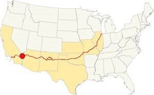
Location of Topock on U.S. Hwy. 66, Arizona
Topock's low altitude gives it very hot summers. The area has a "Subtropical desert climate". Dry and hot, with severe thunderstorms during the summer monsoon season.
Rainfall is scarce, only 4.6 in. per year with only 23 rainy days per year. Hardly ever snows though, in 1949, 12.2 inches of snow fell in the area.
Summer average high (Jul) 109°F (42.8°C) and average low 84°F (28.9°C). Winter average high (Jan) 65°F (18.3°C) and average low 44°F (6.7°C).
Tornado risk
As Topock is west of the Rocky Montains, there are virtually no tornados there.
Tornado Risk: read more about Tornado Risk along Route66.
Map of Route 66 in Topock, AZ
Map with the alignment of Route 66 through Topock
Visit our Kingman to Topock page for a detailed description of Route 66 through Topock. Below is the color coded interactive map:
>> Custom map of Route 66 in Topock
The next segment is described here: Topock to Barstow - Map of this segment

Thumbnail of the 1935 Arizona highway map. Credits
Click on thumbnail map to enlarge
Route 66 was aligned across the Black Mountains in 1926 it linked Kingman and Topock via Oatman, a rich mining town.
At Topock the highway crossed the Colorado River (we describe the bridges it used, in detail, further down).
The highway was realigned following the Santa Fe tracks along Sacramento Wash, via Yucca, in 1952. This was flat ground and avoided the dangerous mountain road with hairpin bends and Sitgreaves Pass between Oatman and Kingman.
See this map of the US 66 alignment from Kingman to Topock (1926-52). We describe it in detail in the link below (Kingman to Topock):
The Route 66 alignment in Topock
Visit our pages with old maps and plenty of maps and information about US 66's alignments:
- Topock to Barstow (Next)
- Kingman to Topock (Topock's)
- Williams to Kingman AZ (Previous)

Sights and Attractions in Topock, Arizona
If you visit the Grand Canyon
Some tours and sightseeing
Sponsored
Route 66 reaches the Colorado River Bridges
Historic context, the classic Route 66 in Topock
In 1946, just after World War II ended, and just as the large flow of veterans began their new lives along the Western Coast, many of them moving west along Route 66, Jack DeVere Rittenhouse wrote his book, "A Guide Book to Highway 66". It gives us an insight into what it was to drive along the Mother Road during its heyday. Rittenhouse mentions the following about Topock:
.Gas; grocery; few cabins; garage for light repairs; limited facilities Rittenhouse (1946)
All of these places have long since gone due to the changes introduced in the highways by the different bridges built to get across the Colorado River and by the construction of I-40.
Topock Then and Now
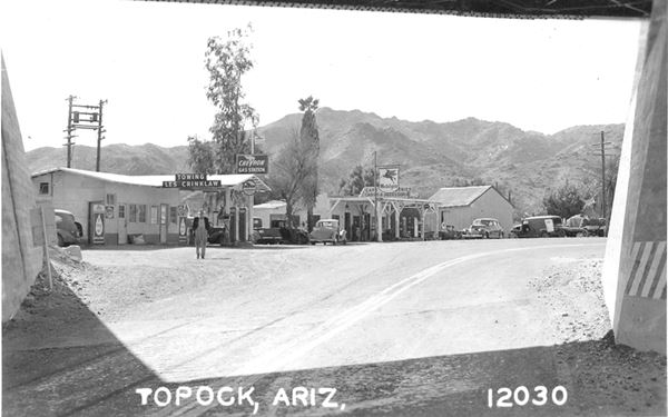
The image below shows Chevron and a Mobil gas stationsm Les Crinklaw's towing, and a cafe with cabins (now I-40 runs across it).
A view of "Old" Topock in a vintage postcard
The same US 66 underpass nowadays:
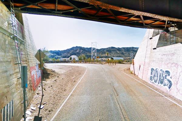
Topock: razed by I-40
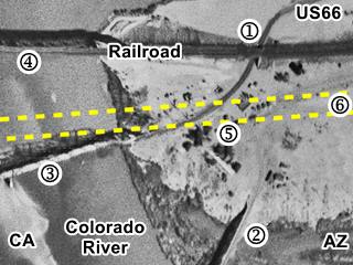
The thumbnail (click on it to see the full size image) image shows an aerial photograph taken in 1947. The main features are the following: (1) Route 66 underpass at the Santa Fe railroad. Still standing. (2) Is the Trails Arch bridge that carried US 66 from 1926 to 1947. (3) The old Red Rock railroad bridge, that in 1947 became the highway bridge carrying Route 66 across the Colorado River, when the railroad built the (4) "New" Red Rock bridge, still in use.
(5) shows the buildings at Topock and (6) as a yellow dashed line, the area now occupied by I-40 and its frontage roads that razed the original buildings at Topock.
A Description of Old Topock
The original Route 66 from Oatman curved southwards in a wide arch and passed under the Santa Fe railroad. The underpass was built in 1944 (perhaps to make it safer for the wartime traffic (1).
Water Tower
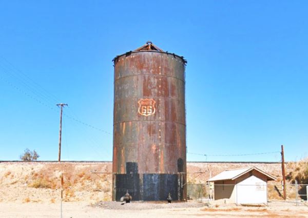
On the south side of the tracks was a small depot with a rusting water tower built by the Santa Fe railroad in 1908. It has a Route 66 painted on it. It is 24 feet diameter and 43 feet high with a conical roof. It contained raw water for the steam engines (2).
The gas stations (Gone)
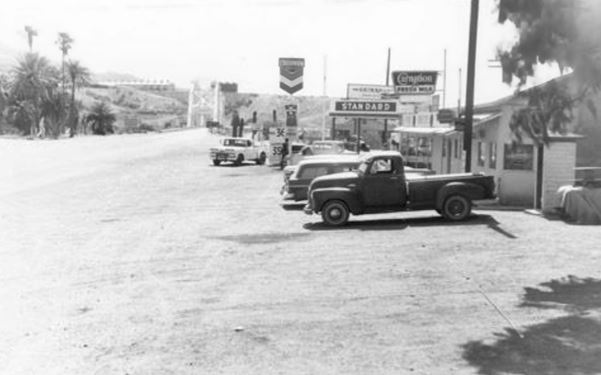
They were originally lined up towards the Arches Bridge, south of the underpass, but in 1947 realigned along the new course of US66 that curved west after the underpass towards the Red Rocks Bridge.
The picture below looks west towards California, to the right (north) are some gas stations, and in the distance the Red Rock bridge. The railroad embankment is to the right, out of view.
This picture was taken just before the construction of the freeway began in the 1960s.
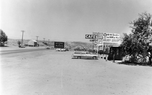
Below is the view looking eastwards into Arizona, showing the south side of the 1952 Route 66. Notice the "Welcome to Arizona" sign by the highway. The railroad can be seen on the left.
Check out all of these photos from 1968 online in their original sizes (external website).
The Needles
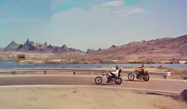
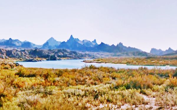
In the two views from the underpass, the mountains known as "The Needles" can be seen in the distance. They are part of Topock and its charm and have appeared as the backdrop in several movies.
The movies
Grapes of Wrath and The Needles
The book by John Steinbeck and the movie it inspired, directed by John Ford, portrayed the tragic story of an Oklahoma family, the Joads, who lost their farm during the Great Depression and migrated to California seeking new opportunities.
In this Pulitzer Prize-winning work, Steinbeck (who later won the Nobel Prize in Literature) depicts their tragic journey (along Route 66). He also coined the phrase "Mother Road", referring to U.S. 66.
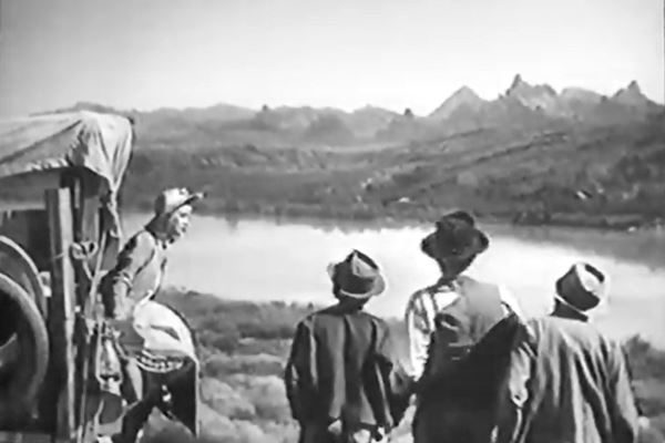
There is a long a scene (watch the Video further up) in the 1940 movie showing the Joads as they reach Topock and park by the Colorado River bridge, and then cross it. The still below show part of this scene and it shows "The Needles" beyond the curve in the Colorado River:
> > learn more about The Grapes of Wrath, full details on the book and the movie.
Easy Rider
The Needles and the Red Rock bridge appear in the 1969 movie "Easy Rider" with Peter Fonda and Dennis Hopper as two bikers Wyatt and Billy. The movie has many scenes shot in Arizona (Flagstaff, Bellemont). Below is a still with the jagged Needles and the old bridge in the opening scenes of the movie; watch the Video further up.
Topock and Hollywood Trivia: The Fondas
The Colorado River and Topock link actor Henry Fonda, who was filmed here in "The Grapes of Wrath" and his son Peter Fonda did so in the "Easy Rider".
The Geology of The Needles
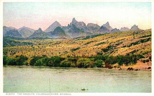
These mountains are about three miles south of Topock. They have a peculiar profile with sharp jagged peaks and pinnacles. Their height ranges from 1200 to 1600 feet.
They were named by Lt. A. W. Whipple during his expedition in 1854 to find a route for a transcontinental railroad along the 35th parallel. He wrote, describing the terrain:
the worst yet. It was a confused mass of gorges, precipices, and serrated crests several thousand feet high Whipple (1854)
Here the Colorado River runs between to abrupt mountain ranges: The Needles and the Chemehuevi Mountains; it formed the narrow Topock Gorge with its sharp Devil's Elbow turn.
The mountains have a complex geological history including massive basalt flows and intrusions, and a gigantic eruption of a volcano in the southern Black Mountains that covered the area with tuff some 19 Million years ago. Dikes can also bee seen, they are the remains of the lava that solidified in the chimneys of long gone volcanos.
PG&E Topock compressor station
On the south side of the freeway is a natural gas compressor station beside the old Arch Bridge. It was built to pump the gas from gas fields in Texas to northern California.
It is their pipeline that saved the old Trails Arch bridge: it carries the gas pipeline across the Colorado River.
Nowadays there are no visitor services at Topock. There is a restaurant, bar, gift shop, and swimming pool at Topock66 Resort and Topock Marina used by boaters to refuel, both of them located on the north side of the railroad, next to the Topock Marsh area.
The bridges in Topock
Five bridges were built to cross the Colorado River south of Needles:
- The First Railroad Bridge, gone, 1883 - 1890
- The Red Rock Railroad Bridge, 1890 - 1947 Railroad Bridge (later 1947-66 U.S. 66 Bridge)
- The Trails Arch Bridge, 1916 - 1947 (Road Bridge)
- The New Red Rock Railway Bridge, since 1945
- The Freeway Bridge, after 1966
Looking east from California into Arizona, the three bridges.
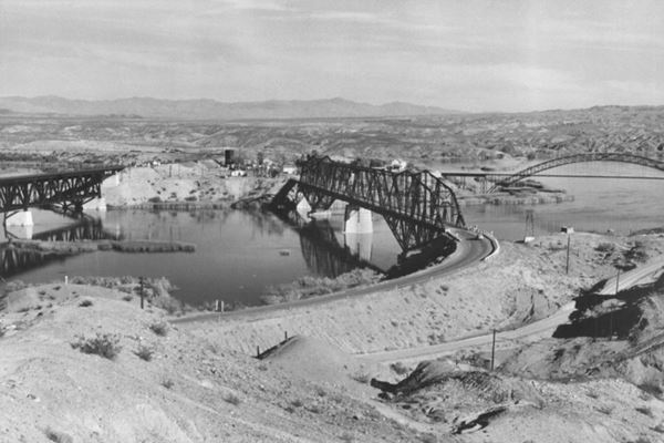
The picture above taken between 1947 and 1969 show, from left to right, the New Red Rock Railroad Bridge, the "old" Red Rock Railroad Bridge, that carried the railroad from 1890 to 1947 and US 66 from 1947 to 1966, with the highway leaving its western tip and curving left (north), and the original Trails Arch bridge (far right) with its access road, the 1926-47 US 66 crossing the image along the bottom. The freeway hadn't been built when the picture was taken. Topock can be seen in the distance, in Arizona.
First Railroad Bridge
The Atchison, Topeka and Santa Fe Railroad, (AT &SF) which controlled the Atlantic and Pacific Railway (A&P), built its line across Arizona from Kingman (1882) towards the Colorado River to reach Needles, California. They built a bridge and completed it on August 3, 1883, reaching Needles.
First bridges: destroyed by floods
The site for the first bridge was a "Eastbridge", 3 miles south of Needles. There the local workers drove pilons into the soft river bed to support the wooden bridge they would build across the Colorado River. The bridge, completed in August 1883 was washed away by the spring flood season.
Red Rock Bridge (1890)
A new bridge was built in 1884, and again in 1886 and 1888. The floods and the unsuitable location for the bridge site (sandy clay soil) led the engineers to relocate the bridge further south in 1890.
They chose a point with solid bedrock foundations beyond the marshes and the mouth of the Sacramento Wash, at a narrow spot at Beal, CA, facing Mellen Arizona (now known as Topock) where there was a solid rock foundation for the bridge. There they built a steel cantilever bridge, the "Railway Red Rock Brige".
The steel cantilever bridge
The bridge cost over $460,000 which is more than $15 million 2022 dollars) and was America's longest cantilever bridge.
Cantilever bridges
A cantilever bridge uses cantilevers which are structures that extende horizontally, from a supporting point, at one end. These cantilevers can range from simple beams to steel or concrete frames. Steel cantilevers can span more than 1,500 ft. (460 m) and are easily built.
It could carry 3,000 lbs. per linear foot, but trains and their cargo increased as time went by so the bridge was reinforced in 1901 to carry heavier loads.
To carry even heavier trains, a support pier was added in the middle of the span thus the bridge was no longer a cantilever bridge.
It spanned the river alone until 1916 when, a few hundred yards downstream, a new bridge was built for automobiles.
Trails Arch Bridge
Listed in the National Register of Historic Places in 1988.
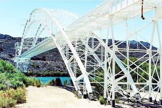
The Topock Bridge, Arizona & California. Credits
The cars that drove along the roads of the 1910s, crossed the Colorado River using the Needles Ferry. But a flood razed the ferry in 1914 so the cars crossed the river using the railroad's Red Rock Bridge: planks were laid across the tracks and the cars crossed between trains.
There was a bridge on the "Ocean-to-Ocean" route at Yuma, but the Los Angeles to St. Louis National Old Trails Highway also required a bridge across the Colorado River
In 1914, the states of Arizona and California, the US Bureau of Indian Affairs and San Bernardino County agreed to build a bridge.
The structure is a steel arch bridge with a "cantilever system" where the arch was assembled in two halves on each side of the river and then hoisted into place and linked together with a ball-and-socket central hinge.
At 800 ft. (243 m) in length and with a span of 600 ft. (182 m), it was the longest arch bridge in America until 1928.
The bridge was completed on Feb. 20, 1916 and carried the traffic of the N.O.T. highway. In 1926, U.S. 66 was aligned across it and remained so until 1947 when it was replaced by the Red Rock Bridge which the AT&SF railroad had just stopped using.
Its deck was removed in 1948 and a natural gas pipeline was laid across it; it is still in use.
We marked the course of the 1926-47 Route 66 from Topock AZ to California across this bridge with a pink line in our custom map of Route 66 in AZ.
Viewing the Trails Arch Bridge
From the California side of the river you can get a good view the old Arch Bridge from this vantage point (Map and Directions from Topock AZ), there is a concrete billboard and a parking space. The Billboard says "Welcome, Turn Right Next Exit" with a Route 66 shield.
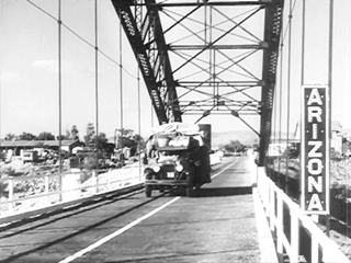
Dust Bowl and the Great Depression, "Grapes of Wrath", US66 and the Colorado River Bridge
The black and white image is a still from the movie "The Grapes of Wrath" showing the Joads on U.S. 66 crossing the Colorado River along the steel arch bridge in 1940.
New Red Rock Railroad Bridge
The heavy military cargoes during World War II led the AT&SF railroad to plan and build a new bridge just north of the original one.
It was completed in February 1945: a high level double-track bridge. This bridge is still in use today.
Route 66 Red Rock Bridge: Carried vehicles after 1947
The Trails Arch Bridge was a very narrow bridge and only one lane crossed it, it also had a sharp 90° turn on the Californian side. It had a low carrying weight (11 tons); as trucks carried heavier loads a new bridge became necessary.
When the railway completed the "new Red Rock Bridge" the "old" bridge was modified to accommodate U.S. 66 trafic in 1947 and continued carrying traffic until it was replaced by the I-40 bridge in 1966. The old steel structure was removed in 1978.
We marked the course of the 1947-66 Route 66 from Topock AZ to California across this bridge with a dark blue line in our custom map of Route 66 in AZ.
These two aerial photographs reflect the changes over the years:
This aerial photograph taken in 1947 shows, from top (north) to bottom (south), the three bridges that crossed the Colorado River at that time. The 1969 aerial photo shows all bridges, including the one carrying I-40.
Interstate I-40 Bridge
The Interstate system launched in 1956 reached the Colorado River in 1966 and a new bridge was built to carry it across the river: a four laned steel girder structure supported by concrete piers.
The old Cantilever bridge was abandoned and closed to traffic.
It was finally dismantled in 1978 and you can see its plaque at the nearby Needles Museum.
Continue your Road Trip along Route 66:
This marks the end of your city tour of Topock, continue your Route 66 Road Trip by heading west into California using the Freeway to cross the Colorado River and had towards Needles the next stop of your Route 66 road trip.
Tours, Outdoors, National and State Parks
Warm Springs Wilderness Area
The Black Mountains to the east of Topock are part of the Warm Springs Wilderness Area.
Topock Marsh and the Havasu National Wildlife Refuge
Topock Marsh was created by the backwater that flooded the lowlands north of Topock after the construction of Parker Dam.
There are several boat launches with access to the Colorado River such as the Topock Marina, Arizona (exit 1, I-40) and Park Moabi (across the river in California).
Topock Marsh is ideal for canoeing or kayaking. Reach the water at: North Dike, Five Mile Landing and Catfish Paradise.
It is a great bird watching spot too. Read more at the Official Havasu National Wildlife Refuge website.
The Historic Route 66 Back Country Byway

Back Country Byway sign. Austin Whittall.
Back Country Byway
This section of Route 66 from Kingman to Topock through Oatman has been designated a Back Country Byway, within the BLM (Bureau of Land Management).
The road is legally accessible by any vehicle under 40 feet in length. The part of the road passing through the mountains is a very narrow two-lane with no shoulders, extremely tight switchbacks and many steep drop-offs. Wide vehicles and vehicles over 30 feet in length should use extreme caution when driving this road.

Some sponsored content
Lake Havasu City

Lake Havasu City, the lake and London Bridge. Source
The resort town of Lake Havasu City on Lake Havasu has beaches along the lake's scenic shoreline, an active nightlife and the original London bridge (you can take a Tour to visit it)
The adjacent state park is open 24 hs, and there is an entrance fee. It is located on a reservoir on the Colorado River. You can hike and enjoy the riverside.
Visit the scenic shoreline with beautiful beaches, nature trails, boat ramps, and many convenient campsites.
>> Book your Hotel in Lake Havasu City
Learn more about the outdoor sites in the Havasu State Park official website.
>> Book your Hotel in Topock AZ

Credits
Banner image: Hackberry General Store, Hackberry, Arizona by Perla Eichenblat
Jack DeVere Rittenhouse, (1946). A Guide Book to Highway 66.


