Parks Arizona's Route 66
Index to this page
About Parks, Arizona
Facts, Trivia and useful information
Elevation 7,079 ft (2.158 m). Population 1,393 (2025).
Time zone: Mountain (MST): UTC minus 7 hours. Summer (DST) no DST⁄ PDT (UTC-7).
Parks is a tiny village located in Coconino County on the original Route 66 alignment in nortwestern Arizona between Williams and Flagstaff.
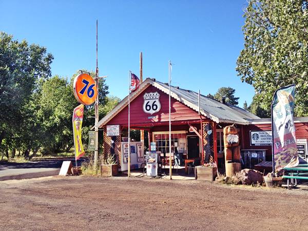
View of Parks General Store from Route 66
The forests between Williams and Flagstaff have been inhabited for over 10,000 years. Until the 1400s, the "Sinagua" natives -their name in Spanish means "without water", grew their crops in the area but were forced east after very severe dry periods. The Spanish who incorporated Arizona into their American colonies never settled the area, and left it to Mexico after it became independent in 1821.
Mexico lost Arizona to the U.S. after its defeat in the 1846-48 War and the region was explored by U.S. Army officer Edward "Ned" Fitzgerald Beale who surveyed a route from Fort Smith in Arkansas to California (roughly following the course taken later by Route 66 west of Oklahoma City).
Beale rode through what is now Parks in 1857 and the trail he opened can still be seen.
Arizona became a separate territory from New Mexico during the American Civil War (1863).
Settlers arrived after the Navajo were relocated to their reservation and sheep herders set up their homesteads in the grassy patches in the forest west of Flagstaff.
The Atlantic & Pacific Railroad (later the Atchison Topeka and Santa Fe Railroad) built its tracks westwards towards California and built a siding near modern Parks in 1883. T. Dennis opened a saw mill there, shipping out railroad ties cut from the local timber.
A village grew around the mill and the post office opened in 1898. Dennis named it "Rhodes", which somehow mutated into "Rhoades". Shortly after the U.S. battleship Maine was sunk in Havana, Cuba by an explosion in 1898 (which led to the Spanish - American war), the town and station were named Maine and approved by the U.S. Postal Service in 1907.
When the first highway was laid through the area in 1906, the village relocated two miles to the northwest, and the old station became "Old Maine" while the new town became "Maine".
It was then that the original general store was built by McMillan on a grant of land given to him by the U.S. Government in 1910.
The National Old Trails (N.O.T.) highway was completed through Parks in 1921 and the first road to the Grand Canyon was built north of the town that same year. Harold Longfellow and Harold Cameron opened a gas station and grocery store there (though some versions say that the store was built on the junction by Art Anderson and Don McMillan in 1921).
That same year, the town was renamed Parks, after the post office which had moved there in 1915. In 1926, Route 66 was aligned down the N.O.T and a growing flow of motorists drove down the new unpaved highway.
The name: Parks
The myth is that the owner of the general store was a man named Parks and the town took its name after him. But that is not true.
The village is located near many open areas, free of timber, which the local residents called "parks", and that gave it its name.
Later second road was completed to the Grand Canyon from Williams. Even as late as 1930, the town was still named "Maine" on some maps or Maine followed by (Parks P.O.). The Grand Canyon road and the town don't appear in the Arizona D.O.T. highway map of 1935, but it shows that route 66 was paved at that time. U.S. Highway 66 was realigned in 1964 along what is now I-40, bypassing the few stores and gas stations in Parks.
Getting to Parks
You can reach Parks along Old Route 66 from Bellemont or via Interstate 40 west of Bellemont at exit 178. Head east from Williams along old US 66 into Parks.
Accommodation: Where to Stay in Parks
Find your room in the motels in neighboring Williams, Bellemont, or Flagstaff (sponsored content):
>> Book your room in neighboring Bellemont
More Accommodation near Parks on Route 66
There are plenty of lodging options in the cities and towns along Route 66 east and west of Parks; click on the links below to find your accommodation in these towns, listed from east to west:
Eastwards
In Arizona Along Route 66
Westwards
You are so close to Las Vegas and the Grand Canyon!
There is an RV campground in Parks
The Weather in Parks
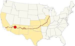
Location of Parks AZ on Route 66
Parks has a dry and semi-continental climate with well defined seasons. Winters are cold and have heavy snowfall while summers are hot and dry until the humid summer monsoon period that begins in July. Spring is windy but dry like Fall.
The average high temperature in summer (July) is 79°F (26°C) and in winter (Jan), the average high is 42°F (5.8°C).
The average low in summer is 44°F (6.4°C); falling in winter to a below freezing 11°F, (-11.4°C).
Rainfall is not abundant, reaching 20.1 in per year (512 mm). Of these about 8.8 in. (224 mm) fall during the Summer Monsoon period from July and Oct with another 8 inches during Winter.
Due to its height altitude there is a lot of snow during winter: 74 inches of snow fall in the area each year (188 cm) snow starts during late Sept. and even in early May you may encounter snow.
Tornado risk
Tornados are extremely rare west of the Rocky Mountains and almost unheard of in Arizona. Nevertheless there were tornadoes in neighbouring Bellemont, four miles east of Parks:
The 2010 Bellemont Tornadoes
Bellemont was hit by two tornadoes in the largest single-day tornado-event in the history of Arizona: eight tornadoes struck the state.
They hit during Oct. 2010 and the 1st Bellemont tornado was the longest tracked tornado in Arizona history with a path of 34 miles (54 km) it damaged 100 homes and injured 7 people.
Tornado Risk: read more about Tornado Risk along Route66.
Map of Route 66 in Parks, AZ
Visit our Winona to Williams Alignment page for a detailed description of Route 66 through Parks. Below is the color coded interactive map:
>> Custom map of Route 66 in Parks

Thumbnail of the 1925 N.O.T. map at Parks. Credits
Click on thumbnail map to enlarge
Click on the thumbnail map to enlarge it. Parks appears as "Parks or Maine" and future Route 66 is an "improved road" as marked by the dashed line; notice the highway heading north to the Grand Canyon. The numbers on the map mark the "Trails": 22 is the National Old Trails Road, 32 is the New Santa Fe Trail, 64 is the National Park to Park Hwy.
Access to the Grand Canyon
The National Old Trails (N.O.T) Highway built in the early 1910s was originally planned through Phoenix, but the local authorities managed to have it routed from Needles through Williams and then onwards to Flagstaff so it could provide access to the Grand Canyon.
The N.O.T highway was completed through Parks in 1921 and from there the first road to the Grand Canyon was built northwards
In 1926, Route 66 was aligned down the N.O.T and a growing flow of motorists drove down the new unpaved highway.
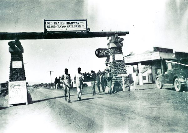
In 1928, the Trans-Continental Footrace was organized by C.C. Pyle and the runners passed through Parks as shown in the photograph below where you can see the General Store (right) and the sign by the right stone pillar pointing north along the Grand Canyon road:
The 1928 Trans Continental Route 66 Footrace and the General Store at Parks.
Later second road was completed to the Grand Canyon from Williams.
There were several alignments between Bellemont and Parks, and from Parks westwards into Williams. We describe them further down in the section about the Historic Segments of Route 66 in Parks (listed in the National Register of Historic Places.)
Route 66 Alignment near Parks AZ
With maps and full information of the old roadway.
- Williams to Kingman (next)
- Winona to Williams (Park's)
- Winslow to Winona (previous)
Parks Arizona, its Sights and Attractions
Things to Do and Places to See in Parks Arizona
Historic context, the classic Route 66
Jack DeVere Rittenhouse mentioned the small village of Parks in his book "A Guide Book to Highway 66", published in 1946. He tells us that:
Parks, another of those 'one establishment towns,' offer gas and a few cabins. Rittenhouse (1946)
He added that one mile west of the store was the "Fireside Inn" which also had gasoline and "a few cabins". Three miles west of Parks was a free camping spot maintained by the U.S. Government, followed, 2 miles west by the "Wagon Wheel Lodge" with gasoline and log cabins. Only the General Store and the Wagon Wheel are still standing.
We will tour Parks driving westwards from Bellemont into Parks and then westwards towards Williams:
The Alignment of Old Route 66 from from Bellemont to Parks
Historic Road Segment

Historic Route 66 sign, Parks AZ. Austin Whittall
Listed in the National Register of Historic Places
There are three separate sections of Route 66 at Parks that are listed in the National Register of Historic Places; they are the following:
Leave I-40 at Exit 185 and head north along the Frontage Rd. it soon heads north towards Brannigan Park in the Kaibab National Forest.
This is the map of the 6.2 mile segment, that you can drive all the way into Parks: Map of the Brannigan Road segment.
1. The older 1926 to 1931 alignment at Brannigan Park
As the route followed by the railroad and modern I-40 from Bellemont to Parks crossed abrupt and rugged terrain with some steep climbs, this alignment that had been used by the 1917 National Old Trails alignment, was abandoned around 1920-21 in favor of a longer but less difficult one that curved to the north around Fortynine Hill (7,850 ft). It ran through a meadow named Brannigan Park.
Route 66 in 1926 was aligned along this earlier 1920-21 roadbed. You can still see parts of the original road winding next to US 66. At Brannigan Park, a large and well-watered meadow set in the middle of the pine tree forest, the original 1926-31 US 66 took a different alignment, now obliterated by nature.
It west, and finally to the southwest, beyond the later Route 66 alignment built in 1931, meeting it close to Parks. You can see it marked with a blue line in our custom map.
There is only one part can be driven today (See map). It finally swung to the north of the later alignments and it can be still seen close to the General Store at Parks.
2. 1931-1941 Brannigan Park Road
Built in 1931-32, it was a 24 foot-wide road, and it was paved by 1934. Now it is partly paved.
This was also the highest point of the whole Route 66, at 7,405 feet above seal level, it was not easy for the early drivers to climb Brannigan Park pass on Fortynine Hill.
Highest Spots Along Route 66
There are several passes along Route 66 where it crosses mountain ranges, the highest spots are the following:
- 7,550 feet (2,301 m). Glorieta Pass NM, Sangre de Cristo Mountains. Highest point from 1926 to 1937. On the Santa Fe Loop.
- 7,405 feet (2,257 m). Bellemont to Parks, Arizona, crossing the San Francisco Mountains, 1931-41 alignment.
- 7,245 feet (2,208 m). Continental Divide, New Mexico, crossing the Rocky Mountains. 1927-85 alignment.
- 7,102 feet (2,166 m). Sedillo, NM on the 1937-45 alignment, replaced when it was realigned, by a spot at 7.057 feet (2,150 m). Comer's Cafe close to Sedillo on the 1945-85 alignment. Crossing the Sandia Mountains.
- 3,595 ft (1,096 m). Sitgreaves Pass near Oatman, California, crossing the Black Mountains. 1926-53 alignment.
3. Historic abandoned Section East of Parks
Listed in the National Register of Historic Places
This section, just east of the Parks General Store was part the road built in 1921, incorporated into US 66 in 1926, and improved by paving and widening it in 1931. (Shown in this map). Now it is a trail that can be walked. Along it are the remains of a springhouse where tourists would camp and get fresh water.
It has a asphalt paving and concrete culverts one of which has a brass plate stamped "1931". Below you can see the old alignment meet the later 1941 one (red arrow is the 1931 roadbed). We marked it with a green line in our custom map.
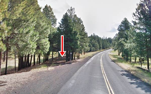
There were some tourist spots along Brannigan Park highway during Route 66's heyday: Jensen's Log Cabin resort with a restaurant, and Harwoods, a lodge with guest cabins and gas station. Both are long gone.
The original road alignment continued west, passing behind the General Store, on its northern side, and heading westwards from there to the north of the modern highway 66. This is a very short segment, and we describe it further down.
Later alignment: 1941 to 1963
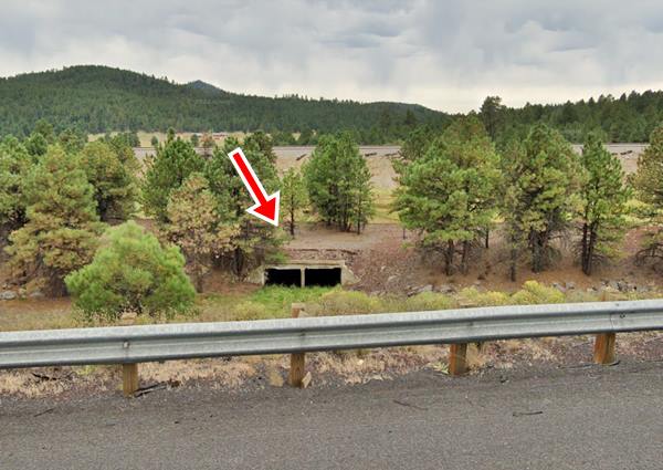
The Brannigan Park segment was replaced by a straighter and shorter roadway running more or less where I-40 is now located. You can see the old roadbed in several places. We marked the original road in our custom map with a purple line at the rest areas west of Bellemont, then it is overlaid by the freeway and again appears (orange line) to enter Parks east of the current Exit 178, where a short segment can still be driven (see this map into Parks 1941-63 Route 66.
Culvert of the 1941-63 Route 66 on the south side of I-44 east of Parks
Parks in the Pines General Store

1930s black and white postcard Parks AZ General Store,Source
To your right on the NE corner of Old Route 66 and N. Spring Valley Rd.
When the first highway was built through the area in 1906, the town moved away from the railway station and relocated on the new road, about 2 miles northwest of the old location.
Don McMillan built a general store there in 1907, at the townsite that was named Maine. In 1910 he received a land grant from the U.S. Government and therefore owned the land where he'd built the store.
When the road was improved and the The National Old Trails (N.O.T.) highway was completed through Parks in 1921, a road was built to the Grand Canyon, and it began right next to the General Store.
At that time Harold Longfellow and Harold Cameron opened a gas station and grocery store there.
In 1926 Route 66 was aligned along the old N.O.T., and its remains can still be seen west of the store on the north side of the road.
By the time it was paved in 1931 US 66 had already been realigned just a few yards to the south of its original alignment, and passed on the other side of the store the owners moved the gas pumps, windows and main entrance to face the new alignment.
Cabins
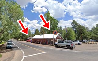
Cabins were added to the complex at that time. The images show a postcard from the 1930s and the same view nowadays, the red arrows mark the two buildings seen in the lower part of the black and white 1930s picture, the store and another woodframe building behind it:
The store, which predates the Mother Road is still open!
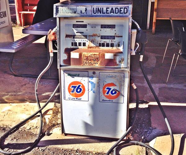
Route 66 Historic abandoned Section west of the General Store
The original 1920s roadbed continued west, passing on the north side of the iconic Parks Store roughly 50 yards north of the modern highway.
Listed in the National Register of Historic Places
A 0.35 mile section of road was built in 1921 as the National Old Trails road and incorporated into Route 66's alignment in 1926. It is a narrow road with a "paved" surface formed by tarred gravel. And it can still be seen and walked along as it lies just a few tens of yards north of modern Old Route 66. (See the green line right side of General store in our custom map).
Dead Man's Curve
The western tip of this segment ended in a sharp curve which the local newspaper called the "Dead Man's Curve" after the accidents it caused.
The 1931 realignment improved the road and straightened the road west of Parks.
Westwards towards Williams
The N.O.T and 1926-31 US66 alignment then turned to the SW and met current I-40 at the N. Spitz Spring Rd. overpass. (Green line in our interactive custom map); it can't be driven along this segment. It crosses the freeway several times and can only be driven along this segment towards Beacon hill.
The alignment after 1931
This is the map of the extant 1941-1963 road into Parks. The roadway that would become I-40 was built in 1964 and finished in 1979.
More Route 66 icons close to Parks
Parks had a strategic location on Route 66, roughly halfway between Flagstaff and Williams. It provided travelers with gasoline, lodging, and food. Besides the General Store mentioned above there were other places that catered to the tourists. Some are now gone, but others have survives.
Beside the General Store was "Pine Springs Camp" and a garage, both from 1933-35.
Cafe
Just ahead, to your right, the Arizona Route 66 survey mentions a "Cafe" at 12431 E Old Route 66. The stone building with a gable roof is still there, and it dates back to 1935.
Maurice's Motel and Café
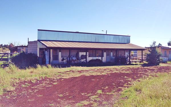
Head west, to your left is former "Maurice's Motel - Café" at 12260 E Old Route 66. It was operated by Pat O'Neil, who intended to restore the old Auto Court. Since his death in 2004, the place has gradually fallen in disrepair. It formerly was known as Louie Long Apartments & Louie Long Motel. Dating from the 1950s.
Maurice's Motel and Café Parks Route 66
Places that have closed or faded away
Three Bears
Across from Maurice's is a former cafe and garage; it was torn down in the 2010s. The Service Station was built in 1945 on the west side of the property, and the Three Bears Café built in 1948 to the right. it was located on the north side of the highway at 12913 E Old Route 66; below is a Then (1992) and Now (2022) sequence of pictures:
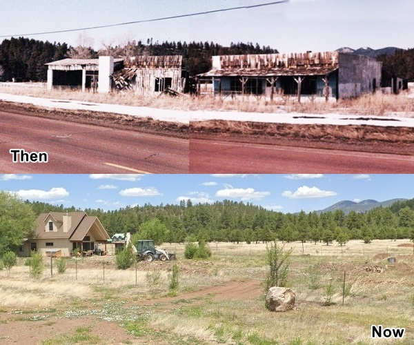
The Arizona Route 66 survey mentions another garage on the south side of the highway (12102 E Old Rte. 66) built in 1950, and to your right, just ahead, on the curve, was the Fireside Inn (at 11961 E Old Route 66), It was built in 1938. Rittenhouse mentions it as "Fireside Inn here, with gas and a few cabins".
Half a mile west is the old Spitz Springs Forest Camp, a camping spot mentioned by Rittenhouse; located on the south side of the highway it was a "tree-shaded" spot, but camping is no longer allowed there (Street View).
Pitman Valley and its log cabin: The Wagon Wheel
Head west for 4 miles and you will reach Pitman Valley, on the western tip of the Old Route 66 segment at Parks, next to Exit 171 on I-40.
The two story log cabin in Pitman Valley AZ
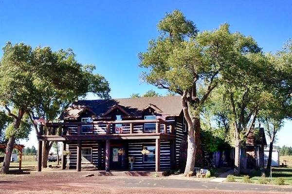
To your right is the oldest building in the area is a two-story log house, on the north side of the road just before interchange 171.
It was known as the "McHat Inn", and later as the "Wagon Wheel Lodge". Rittenhouse mentions it back in 1946; at that time it had log cabins and a gas station, now it is a private residence.
The Elmo Dance Hall which stood across the highway, is no longer there. The railway had a watering stop here, named "Chalender".
The highway continued in a straight line, now it is cut by the freeway. It resurfaces beyond Exit 171 on the south side of I-40 ( learn more: Alignment in Pitman Valley).
Your Route 66 road trip leg through Parks ends here. You can head west into Williams and continue your journey. You can also visit the Grand Canyon
Outdoors and Nature
Beale Wagon Road
A Historic Trail from the mid 1800s
This is a 48 mile tour from Parks to I-40 at Williams, through dirt roads in the Kaibab National Forest. Check road conditions with the locals. See Map.
The Beale Wagon Road was surveyed and opened by Lieutenant Beale and his expedition in 1857. It was the main route into California across the Great Plains from Fort Smith in Arkansas.
Gold seekers and settlers used this Trail to reach the Pacific coast until the railway replaced it in the early 1880s.
You can still see relatively undisturbed stretches of Beale's Wagon road and walk them or ride along them on horseback (cars, ATVs and bikes are not allowed on the trail).
In some section Beale's historic Road is now a Foreset Service Road and can be driven on. There are parking areas and interpretative stations along the way. Don't miss the words “Laws Spring” engraved on a basalt boulder, at the key watering spot in the area. It was the work of a tombstone engraver who was part of Beale's expedition.
Beale Wagon Road Trivia: Camels
The expedition led by Lt. Edward Fitzgerald "Ned" Beale (1822 - 1893) to survey and build a wagon road used camels, imported from Tunis as pack animals.
Though hardier than mules, the camels scared both horses and mules. The Army decided not to use camels in the future.
More information: Kaibab National Forest, Williams Ranger District, 742 South Clover Road, Williams, AZ 86046. (928) 635-5600.
Grand Canyon National Park
World Heritage site of UNESCO
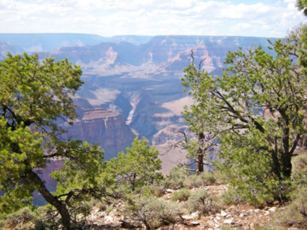
The famous park is only 68 miles north of Parks along old US66, NM 64 and US 180. See this Map with directions.
The incredible Grand Canyon is a short drive away from Williams; plan a full day trip to visit it. You can also go by train.
>>More information at our webpage: Grand Canyon and Route 66.
>> You can book a room in the Grand Canyon Area.

Some sponsored content
Lake Havasu City

Lake Havasu City, the lake and London Bridge. Source
The resort town of Lake Havasu City on Lake Havasu has beaches along the lake's scenic shoreline, an active nightlife and the original London bridge (you can take a Tour to visit it)
The adjacent state park is open 24 hs, and there is an entrance fee. It is located on a reservoir on the Colorado River. You can hike and enjoy the riverside.
Visit the scenic shoreline with beautiful beaches, nature trails, boat ramps, and many convenient campsites.
>> Book your Hotel in Lake Havasu City
Learn more about the outdoor sites in the Havasu State Park official website.
>> Book your hotel in Bellemont, next to Parks

Credits
Banner image: Hackberry General Store, Hackberry, Arizona by Perla Eichenblat
Jack DeVere Rittenhouse, (1946). A Guide Book to Highway 66.


