Route 66 Meets the Forest and Volcanos
Index to this page
About Winona, Arizona
Facts, Trivia and useful information
Elevation 6,240 ft (1.902 m). Population n⁄a (2025).
Time zone: Mountain (MST): UTC minus 7 hours. Summer (DST) no DST⁄ PDT (UTC-7).
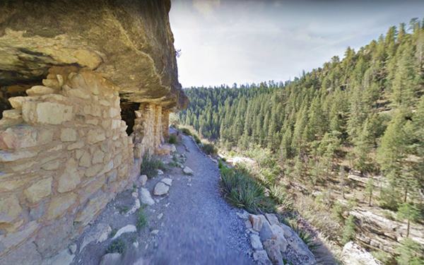
View at Walnut Canyon National Monument near Winona, Arizona; Route 66
Winona is a tiny unincorporated village in Coconino County in the nortwestern part of Arizona. In the 1950s it became a part of Flagstaff.
This part of northern Arizona has been inhabited for more than 10,000 years. The area near Winona was peopled by the "Sinagua" people who lived in an area around Flagstaff, close to the San Francisco Peaks between the Mogollon Rim, Verde Valley, Sedona, Wupatki, Sunset Crater and the Little Colorado River.
Sing at the Winona Trading Post, the San Francisco mountains in the background.

The name "Sinagua" comes from the Spanish words "sin" (without) and "agua" (water), which is the name they gave the San Francisco Peaks, which lacked permanent rivers.
They were hunter gatherers and farmers who grew corn, beans and squash. They flourished between 500 and 1220 AD. A dry period led them to move towards the southwest and east into New Mexico towards Zuni as did the Anasazi people. They had all gone by the 1400's.
Ruins of their homes can be seen in many sites across the region, such as Winona, Walnut Canyon, Elden Pueblo, and Wupatki. The hunter gatherer Navajo (Diné) people occupied the territory to the east of Winona, and the Hopi lived just to the northeast. The Hopi were neighbors of the Sinagua, and descend from the Anasazi people, and like them are farmers.
The Hopi village of "Old Oraibi" is one of the oldest continuously inhabited villages in the U.S.
The Spanish explored, but never occupied this area after they conquered Nueva Mejico in 1597. Following its independence from Spain in 1821, Mexico "inherited" the territory only to lose it to the U.S. after its defeat in the 1846-48 War.
Whipple Expedition
In 1853, the U.S. Congress commissioned Amiel Weeks Whipple (1817 - 1863), a Captain of the Army Topographical Corps, to survey a proposed transcontinental railroad.
He surveyed a wagon trail along the 35th parallel from Fort Smith, Arkansas to Los Angeles, California. He stopped at a spot with deep permanent water "tanks", just north of Winona, at Turkey Tanks.
In 1857, Lt. Edward Fitzgerald "Ned" Beale (1822 - 1893) surveyed a wagon road from Ft. Smith Arkansas to California and passed just north of Winslow en route to Flagstaff. Beale employed camels, imported from Africa as pack animals. Although they were hardier than mules the Army declined to use them in the future because the camels scared both horses and mules.
During the American Civil War, the Unionist government created the Territory of Arizona (1863) separating it from New Mexico and in 1870 a fort was built nearby at Holbrook. In 1876 the Mormons from Utah moved south to settle in Arizona, they used a trail which was later known as the Honeymoon trail
The Navajo people and the Apache were pacified between 1862 and the mid 1870s. Settlers arrived at that time, attracted by the timber and the chance to raise sheep and cattle.
In the early 1880s, the Atlantic and Pacific Railroad, later Atchison Topeka and Santa Fe Railroad (AT&SF) laid their tracks through what is now Winslow. In 1883 it linked up with their California railroad at Needles, CA. forming a transcontinental rail link.
The name: Winona
Winona was originally named "Walnut" when the railway reached the area, after the creek that flowed by the station.
The Arizona walnut was very common along the creek, but now are les so due to the decreased water flow caused by upstream dams.
The name changed to Winona in 1886 because there was another Walnut on the railroad. The name was "just another name" and was chosen for no special name.
However, an USGS Map from 1899 shows the station at present Winona named "Cosnino". By 1915 however, Cosnino had moved further west to its present location and Winona appeared on the map.
Winona is a femenine given name that means "Firstborn daughter" in Dakota language. It was the name of the daughter of Wapasha III, a Sioux Dakota Indian chief.
In the early 1900s a shorter route than Whipple's wagon road between Winslow and Flagstaff became necessary. The National Old Trails highway association surveyed one through Winslow. Route 66 was aligned along the National Old Trails in 1926 and traffic began flowing through Winona.
Where to Stay; lodging
There is lodging on Route 66 very close to Winona.
>> Book your Hotel in Flagstaff
Close to the Historic Route 66 bridge, you can rent a 4-bedroom home on airbnb.
Lodging Near Winona along Route 66
More Accommodation near Winona on Route 66
There are plenty of lodging options in the cities and towns along Route 66 east and west of Winona; click on the links below to find your accommodation in these towns, listed from east to west:
Eastwards
In Arizona Along Route 66
Westwards
You are so close to Las Vegas and the Grand Canyon!
>> There is a RV campground close to Winona
Weather in Winona
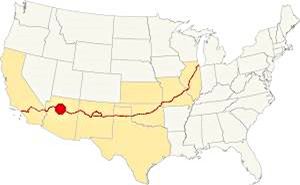
Location of Winona on Route 66
The climate in Winona is dry and semi-continental. Seasons are clearly marked, with cold winters with abundant snow and a dry windy spring. Summer is hot and dry until July, when the humid summer monsoon period begins. Fall is dry and pleasant.
The average high temperature in Winona in summer (July) is 81.2°F (27.3°C). The winter (Jan) average high is 42.5°F (5.8°C). The record high is 96°F (36°C) in July. The average low in summer is 50.9°F (10.5°C) and in winter it is 17.3°F, well below freezing (-8.2°C). Record low is -30°F (-34°C) in January.
Rainfall is scarce and averages 21.86 in per year (555 mm); around 8 in. (200 mm) fall during the Summer Monsoon period between July and Oct, and another 8 inches between December and March.
Yearly 101.7 inches of snow fall in the area (258.3 cm), between late Sept. and early May you may encounter snow.
There are 88 days a year with precipitation, 35 with snow and the relative humidity fluctuates from 34% to 62% (June and January).
Tornado risk
All the region located to the west of Rocky Mountains hardly has any tornados.
Tornado Risk: read more about Tornado Risk along Route66
Map of Route 66 in Winona, AZ
Visit our Winona to Williams Alignment page for a detailed description of Route 66 west of Winona, and see Winslow to Winona page for the eastern section. Below are the color coded interactive maps:
>> Custom map of Route 66 West of Winona
>> Custom map of Route 66 East of Winona
Check out Winona by clicking on the image.
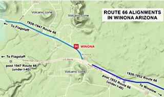
Route 66 Alignments over the years
There were several alignments at Winona. And many gaps that no longer exist. You can see them in our custom map with the missing segments of Route 66 in eastern Arizona.
See the parts that can be driven in the follwoing maps: the clasic 1926 to 1952 map into Winona from the east, and this is the 1926 - 1947 map of Route 66 west from Winona towards Flagstaff
Route 66's Historic US 66 through Winona
Historic U.S. highway 66, "Route 66" has been designated as an All-American Road and National Scenic Byway in the state of Arizona.
The National Old Trails highway became the Flagstaff - Winona highway in 1922 when it was improved using Federal Funds. At that time the Walnut Creek Bridge was built.
In 1926 the Winona to Flagstaff segment of this road became Route 66 and remained so until the road was realigned in 1947 west of Winona. The 1947 alignment is now overlaid by the roadbed of I-40 west of Exit 211 until Exit 204. To the east of Winona, after 1952, US 66 changed its alignment too. Now it is covered by I-40 all the way to Canyon Padre.
The 1926 to 1947 road that took a more northern course became what is now AZ-394.
Click for the Winona to Flagstaff alignment.
Below is a Then-and-Now sequence of images looking east from Winona. The upper image taken in 1966, shows the 1926-1947 alignment into Winona from Flagstaff (bottom left), the post-1947 Route 66 (bottom) and the post 1952 alignment (top) now forming the westbound lanes of I-40.
1966 photo of Winona from the air, looking east.
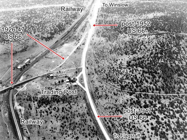
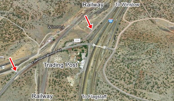
Below is the same view nowadays, I-40 was built and its two lanes running east now cross Winona. The red arrows mark the 1926 alignment.
2021 photo of Winona from the air.
Route 66 Alignment near Winona
With maps and full information of the old roadway.
- Winona to Williams (next)
- Winslow to Winona (Winona's)
- Lupton to Winslow (previous)
Sights and Attractions in Winona
If you visit the Grand Canyon
Some tours and sightseeing
Sponsored
What to Do, Places to See
- In Winona, see below.
- Tours & Itineraries
- Parks and outdoors
In Winona: The Town set between forests and volcanoes
Winona not only has its Winona Trading Post and the historic Walnut Creek Route 66 bridge, built in 1924; it also has many natural attractions too.
Don't miss Walnut Canyon National Monument and the "Chocolate Niagara" Grand Falls on the Little Colorado River.
Outodoors can be exciting, enjoy the forests at the San Francisco Mountains and Coconino National Forest, climbers can enjoy the Turkey Tanks steep rock walls.
Historic context, the classic Route 66
Shortly after World War II, Jack DeVere Rittenhouse drove along US 66 and wrote his "A Guide Book to Highway 66" published in 1946. It is an invaluable resource for those interested in capturing the essence of the "classic" Route 66 of the 1940s.
After leaving Twin Arrows (in those days it was known only as Toonerville), Rittenhouse describes the area as follows:
Many ancient pueblos have been found, since the early Indians undoubtedly also enjoyed the timber and shade.
Filling station operators between here and Flagstaff can direct you to some of these sites.
WINONA. (Alt. 6,005 ft) Winona Trading Post offers cafe, gas, groceries, and several cabins. US 66 now begins to climb more steeply, although there are no difficult grades between here and Flagstaff. Jack DeVere Rittenhouse (1946)
Some Winona Trivia:
Get your Kicks in Winona
"Route Sixty-six": is an emblematic song that immortalized Route 66 in the minds of several generations as an iconic Road Trip, a journey where the traveler can get his kicks, enjoying and savoring the moment and the freedom of riding the Mother Road. It was written by Bobby Troup in 1946 and since then, it has been a hit evoked by all those who have driven (or dream about driving along) Route 66.
Read More: Get your Kicks on Route 66, full details on the song and its context.
Winona is one of the three Arizona towns mentioned in the song (along with Flagstaff and Kingman), and it appears in the following stanza:
Now you go through Saint Looey
Joplin, Missouri,
And Oklahoma City is mighty pretty.
You see Amarillo, Gallup, New Mexico,
Flagstaff, Arizona.
Don't forget Winona,
Kingman, Barstow, San Bernardino.
It is the only town in the song that is not mentioned in its geographic sequence (it appears after Flagstaff, which is further west). This was due to the author's need to find a word that rhymed with "Arizona", and "Winona" was perfect.
Sights in Winona
Volcanic cones
A 1915 Railroad itinerary along the AT&SF railway mentioned the volcanoes: "at Winona there are two small cones a short distance south of the track."
As you approach Winona along I-40 you will notice these volcanos, to the south and the north of the freeway. Low hills that are being mined on their summits and flanks, exposing dark brown, black and red-brown volcanic rocks.
These are volcanic cones, part of the The San Francisco Volcanic Field and are mined for volcanic cinders.
Cinders are used on roads to improve the traction of vehicle tires. They are also used in gardens because being porous, it can hold water.
See this Street View of the volcanoes north of Route 66 in Winona.
Winona Trading Post
Access ramp to I-40 westbound at Exit 211.
After the National Old Trails highway was improved between Winslow and Flagstaff in the early 1920s, Billy Adams built the Winona Trading Post on the new highway near some Indian ruins (Winona Site).
The post office opened in 1924 and his wife Myrtle was the postmaster.
Adams built some wooden cabins and a 14-room motel the following year. In 1926 Route 66 was aligned right in front of his business and remained there until it was upgraded and displaced to a new alignment in 1952, where I-40 is now located.
The Trading Post kept operating on the new corridor; and also had cabins, cafe and a service station. The following postcards shows us what the Trading Post looked like over the course of the years.
Winona Trading Post on US 66 in its heyday. A photo from 1946.
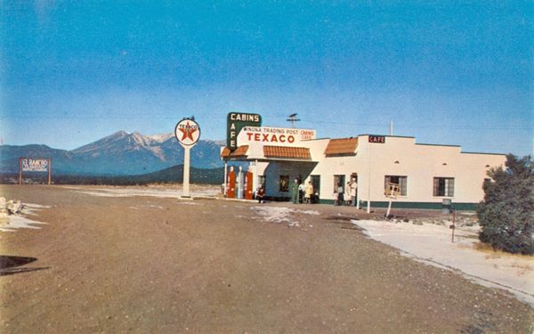
Winona Trading Post
We can see that the garage was added to the original 1946 building (on the left side of the image).
Winona Trading Post on US 66 in its heyday. A postcard from 1956.
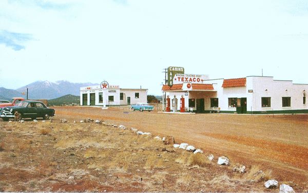
Winona Trading Post
This 1956 postcard has the following text on its back: "WINONA TRADING POST Winona, Ariz. Restaurant, Indian Rugs and Jewelry. One of the best views of San Francisco peaks. Located 16 miles east of Flagstaff on Highway U. S. 66. Mailing Address: Rural Rt. 1, Box 808, Flagstaff, Ariz.".
The current appearance of the place can be seen in the following image.
How the Winona Trading Post looks nowadays
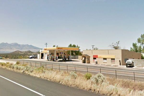
The original "main building" with the cafe and office still stands on the right side, and the old garage building is still there, and is still a garage.
A new modern Shell service station has been built between both buildings and the old pumps and canopy in front of the main building have gone.

Take the original 1926-1947 Route 66 and head west to tour the area.
Tours & Itineraries Near Winona
Route 66 Walnut Canyon Bridge
Old Route 66, Winona, AZ.
Listed in the National Register of Historic Places
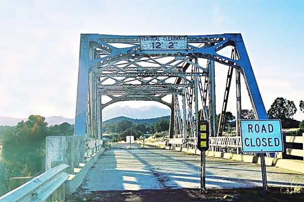
This bridge was built in 1924 to span the Walnut Creek in Winona; it carried Route 66 from 1926 to 1947.
It has a span length of 101 ft. (31 m) and is 124 ft. long (38 m). It is a steel Parker Throughtruss bridge built with five riveted panels.
It is now closed to traffic, but is in very good shape, on the north side of AZ-394. You can park at the pullout place next to it.
The river once carried water but now it is dry most of the time as the dams upstream retain the water in reservoirs for Flagstaff's population.
See a Street view of the bridge.
The bridge is located 1 mile west of I-40s Exit 211 along the 1926-47 Route 66 which is now AZ-394 (Map with directions).
The area around Winona
As you can see, the area surrounding Winona is forested with pines and junipers, a nice contrast to the deserts further east.
There is a historic place close to Winona, related to the conquest of the West.
Turkey Tanks - Cosnino Caves
Historic place
See this Map with directions, it is 4.9 miles north of Walnut Creek Bridge.
Amiel Whipple's expedition camped here on Christmas Eve in 1853. He was surveying a route from Ft. Smith Arkansas to Los Angeles CA.
Next to the water tanks (or watering holes) which he named Turkey Tanks, he found many caves whre the Indians lived. He nnamed them "Cosnino Caves" after the local natives (Coconino Indians).
Whipple's expedition was followed by Beale's in 1857, and Turkey Tanks became an important stop along Beale Wagon Road. When the railroad was built, traffic dropped along the road and the place was abandoned.
There is native rock art at Turkey Tanks (read more on this website).
Winona Meteorite
Arizona is the state with most meteors and metorites along Route 66. It has the gigantic Barringer Crater and the Holbrook Meteor fall of 1912.
There is also a meteor site linked to the native Sinagua people. This is the story.

The cist that contained the meteor
In 1928, a local Flagstaff amateur archaeologist J.A. Townsend while digging at a Sinagua site 5 miles northeast of Winona (map with rough location of the site), came across an unusual find.
He reported his finding to Profesor Byron Cummings of the University of Arizona, and it was reported by Heinman and Brady in the American Journal of Science.
Townsend had found a small "cist", a coffer or burial box made of stone 18 inches square (46 cm), but it didn't contain human remains, instead it held an egg-shaped rock that broke apart when it was taken out of the cist.
This rock was a meteorite that weighed 53 lbs. (24 kg). Being so close to the Barringer Meteor crater you would expect it to be a fragment of that meteor, but it isn't. It is a unique type of meteor, an achondrite that defines the "Winonaite group" composed of only 26 known meteors from places far apart, like the Antarctic, USA and Africa.
Since the Sinagua wouldn't have known it was a special type of meteorite, they must have built the cist to protect and revere the "falling star". In fact there is another Sinagua metorite that was also put in a similar cist.
Native Sites
There are several Sinagua sites in the region, the already mentioned Cosnino Caves and Winona Site, which is very close to the Trading Post (See map), the Ruins of Elden Pueblo is close to Flagstaff, Wupatki National Monument pueblos are north of both towns.
The Sinagua culture peaked between 500 and 1220 AD . But then a severe drought forced them to migrate into New Mexico together with the Anasazi people. By 1400 AD all of them had left Arizona.
Only their abandoned pueblos and dewellings remaind behind. You can see pieces of ceramic, rock art, and their stone homes.
National and State Parks
Enjoying the Outdoors and Nature
The San Francisco Volcanic Field
The volcanic field covers about 1,800 square miles (4.660 km2) is a great outdoors area. Most of it is lies within Coconino and Kaibab National Forests.
The forested volcanic ranges include Piñon, Juniper, Ponderosa Pine, Fir, and Bristlecone Pine. It is ideal for hiking, camping, skiing in winter, and wildlife viewing.
It is roughly centered on Flagstaff but reaches east past Winona and is made up of geologically-young volcanoes (6-million-years-old). The highest one is Humphreys Peak which is also the highest point in Arizona (12,633 ft - 3.853 m).
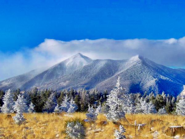
There are several parks to the west, near Winona, like the Sunset Crater Volcano National Monument, Wupatki National Monument, and the Slide Rock State Park; in our Flagstaff page you will find full information on the Outdoors and Parks in the area.
Walnut Canyon National Monument
It is 10 mi. southwest of Winona (see this Map with Directions).
Check the Official website for complete information.
Open daily except Christmas, it has several trails which allow you to spot wildlife and the remains of Native buildings that dot the canyon walls. It became a protected area as a Forest Reserve in the early 1900s, and was designated National Monument 100 years ago, in 1915.
Grand Falls
The "Chocolate Niagara"
It is a 26 mile drive (along a rough and unpaved road -check with the locals before driving there in a regular car) from Winona to the Grand Falls; see this Map with Directions.
Grand Falls on Little Colorado River
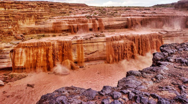
The falls are located inside the Navajo Reservation. March an April is the best time to visit the falls, which become a muddy water torrent falling 190 ft. (58 m). In summer it is mostly a trickle of water.
The Little Colorado River is dry most of the time. It only carries water between March and April during the spring snow-melt period so that is the best time to visit the falls.
A lava river flowed from Merriam Crater and spilled into the canyon of the Little Colorado River 150,000 years ago, it ran downstream for 15 miles and solidified. The lava dammed the river and caused it to deviate and fall over the Kaibab sandstone walls.
Check the Official website of the Navajo Nation Parks & Recreation for more information.
Visit the Grand Canyon
Tip: consider visiting the Grand Canyon on your Road Trip.
Some tours and sightseeing
>> You can Book your hotel in the Grand Canyon Area.
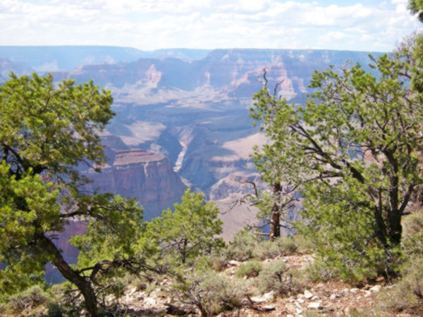
Grand Canyon National Park
World Heritage site of UNESCO
Some sponsored content
Lake Havasu City

Lake Havasu City, the lake and London Bridge. Source
The resort town of Lake Havasu City on Lake Havasu has beaches along the lake's scenic shoreline, an active nightlife and the original London bridge (you can take a Tour to visit it)
The adjacent state park is open 24 hs, and there is an entrance fee. It is located on a reservoir on the Colorado River. You can hike and enjoy the riverside.
Visit the scenic shoreline with beautiful beaches, nature trails, boat ramps, and many convenient campsites.
>> Book your Hotel in Lake Havasu City
Learn more about the outdoor sites in the Havasu State Park official website.
>> Book your Hotel in Holbrook AZ


Credits and Further Reading
Banner image: Hackberry General Store, Hackberry, Arizona by Perla Eichenblat
Robert Emil S. Heineman and Lionel Francis Brady The Winona Meteorite, American Journal of Science December 1929, s5-18 (108) 477-486; DOI: https://doi.org/10.2475/ajs.s5-18.108.477
Meteoritegallery.com, Winona, Winonaite, a photo gallery of the meteorite.
Will Croft Barnes, Arizona Place Names, University of Arizona Press, 1988.
Historic Route 66 in Arizona All-American Road, National Scenic Byway, www.fhwa.dot.gov.


