Foyil, on US 66 in Oklahoma
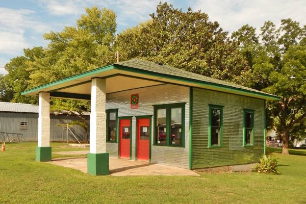
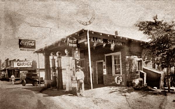
Restored Texaco gas station in Foyil, a historic site
Index to this page
About Foyil, Oklahoma
Facts, Trivia and useful information
Elevation: 761 ft. (233 m). Population: 234 (2010 census).
Time zone: Central (CST): UTC minus 6 hours. Summer (DST) CDT (UTC-5).
Foyil is a very small town 9 miles southwest of Chelsea and 10 miles north of Claremore, in Rogers County, northeastern Oklahoma.
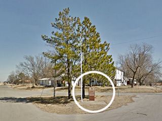
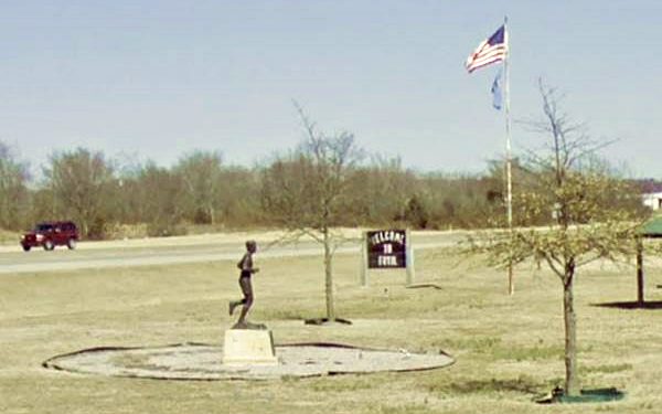
Foyil, Andrew Payne Monument and behind it the post 1962 Route 66
Foyil's History
See Chelsea, History for full information on the region's history.
The first settler in what would later be Foyil was Alfred Foyil. He had been a Confederate soldier and courier during the American Civil War, and he moved into the Indian Territories (which later became Oklahoma) in 1875.
He married the daughter of one of the leading Cherokee families and worked hard to build a log cabin and clear the land for a farm in Redland. He later became quite wealthy and moved west, to another site just north of Claremore, where he established another farm, in what is now Foyil.
The Name Foyil
The town got its name from its first inhabitant, Alfred Foyil. But the surname is quite peculiar. It is found in the US, in Arkansas and Oklahoma after the 1840s. Perhaps it is a deformation of Foyle which in turn is an English surname derived from the Old French word "fouille" which means "pit".
A post office opened on his land in 1890 and he became the first postmaster. The town developed around it. He also ran the local general store.
A drugstore opened in 1898, a bank in 1905, and that same year, the town was incorporated. By 1911 it even had newspapers, a hotel, and two physicians. The creation of Route 66 in 1926 brought some prosperity to the small community but the Great Depression and the Dust Bowl hit it hard.
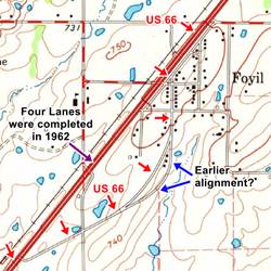
Route 66 was paved in 1931, and in 1962 expanded to a four-lane highway and relocated to the western side of the town.
Getting to Foyil
Foyil is 9 miles southwest of Chelsea. To the south, along Route 66 are Sequoyah and Claremore.
Hotels close to Foyil
Where to Stay
There are several hotels in the neighboring towns of Vinita and Claremore, to the north and south of Foyil. Below is a list of lodging in towns along Route 66 close to Foyil:
> > Book your hotel in Vinita or Claremore
There are several hotels in the area close to this town. Alternatively you can also find your accommodation along Route 66 in the neighboring towns and cities. We list them below (listed from east to west):
More Lodging along Route 66
On Route 66's Main alignment
Eastwards
Westwards
>> There are three RV campgrounds near Chelsea - Foyil.
The Weather in Foyil
Check the Weather and climate of Chelsea for historical weather information.
Tornado Risk: Foyil lies within the "Tornado Alley in Oklahoma and experiences some 8 Tornado watches every year.
Read more about: the risk of Tornadoes on Route66.

Location of Foyil on Route 66
Map of Route 66 in Foyil
Check out Foyil on our Route 66 Map of Oklahoma webpage. It has all of the alignments of Route 66 in the state, and all the towns along them.
An "AutoTrails" map, from 1924 showing the highway through Foyil that would, two years later, become Route 66.
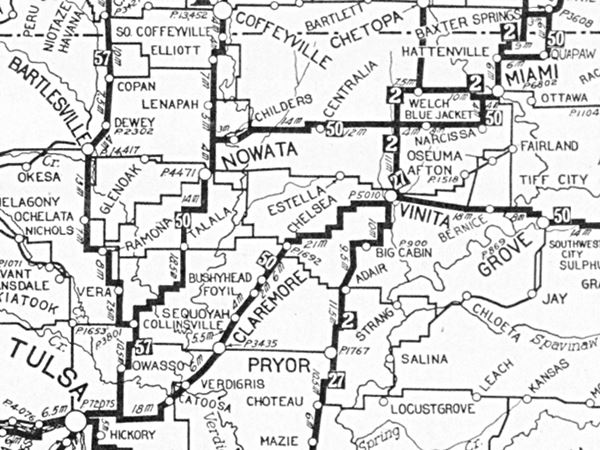
Foyil is in the middle, above Claremore, and the highway was marked as "50", meaning the "Ozark Trails".
Map with the alignment of Route 66 through Foyil
The map (click on it for a large sized map) shows the different alignments of Route 66 through Foyil. The red arrows mark the alignment into Foyil from the North from 1926 to 1962. Then it goes through the town, and meets the later (built in 1962) four-lane alignment south of Foyil.
The original alignment is now under the 1962 westbound lanes.
The curved section marked with a blue arrow is, according to the Oklahoma Dept. of Transportation, possibly the original 1926-31 alignment in Foyil. The red arrows mark the curved section originally paved in 1931 with portland cement, south of the town.
This is the US 66 alignment in Foyil.
Route 66 Alignment near Foyil
Visit our pages with old maps and plenty of information of the old US 66 roadway.
- Tulsa to Chandler (next)
- Vinita to Tulsa (Foyil's)
- KS-OK state line to Vinita (previous)
Route 66 landmarks & attractions
Sights in Foyil
In his 1946 work "Guide Book to Highway 66", Jack DeVere Rittenhouse described the whole of US 66 and mentioned Foyil as follows:
(Pop. 170; gas; small garges; groceries; no cafes or courts.) A small hamlet serving the farms and cattle ranches of the region. Jack DeVere Rittenhouse, 1946
The 1928 Route 66 Footrace Monument
We will tour the town from north to south. At Andy Payne Blvd. (which at one time was named Chestnut Ave.) and Poplar St. The original course of Route 66 north of this point is cut by the eastbound lanes built in 1962 when the highway was expanded to four-lanes. The original highway to the north is under the westbound lanes.
The buildings on the left side of Andy Payne Blvd. were torn down when US 66 became a four-lane highway. You will spot the monument to your right, in the small triangle between Poplar St., E 4th St. and Andy Payne Blvd.
The inscription reads: "Andrew Hartley Payne, a 1927 graduate of Foyil, won the 1928 transcontinental footrace, LA-NYC, a 3423.5 mi. world record in 573 hr 4 min & 34 sec. Andy "Greatest Long Distance Runner in History of Competitive Running" won in the 880 & mile (4:45). He practiced by running to Foyil School 5 miles from the family farm."
Foyil Hotel
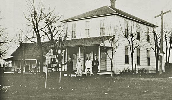
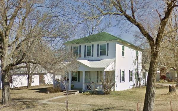
Facing the marker, across old Route 66 is a two-floor house with white wood siding, a front porch and a pyramid hip roof. At one time it was Foyil's hotel, on its Main Street.
It opened around 1900 and was managed by John Andrews. After 1928 Tom and Molly Peters ran it until 1938, when it became a home. As you can see below in the "Then-and-Now" sequence, it has remained unchanged and in great shape.
Historic Texaco Gas Station
Listed in the National Register of Historic Places
Drive along Andy Payne, southwards and on the next block, to your left is a historic landmark.
It is pictured at the top of this page, now fully restored.
The Foyil Filling Station is a "Craftsman style" building with a hipped roof that projects over the pump island. It is held up by two brick pillars and its walls are covered with a tin siding resembling bricks.
It was built in 1923 by Thomas B. Millard, who sold it to his brother William in 1926, the year Route 66 was created. It was bought by George Vincent in 1931 who in turn sold it to Tom Millard's brother in-law, Floyd Shaffer in 1937. He ran the station until the mid 1960s, when it closed for good.
A blurred photo ca.1930 of the Foyil Texaco gas station. Looking North along Route 66.

1931 Alignment in Foyil
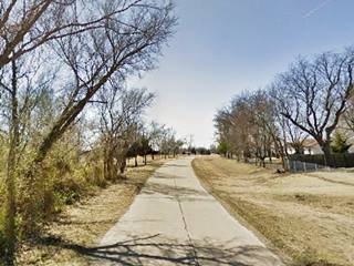
This 0.7 mile-long stretch of Route 66 begins at E 3rd St. and ends next to its intersection with the four-lane Route 66 built in 1962 (see this Map).
It is a narrow two lane road, paved with Portland concrete. Until then, the highway had a dirt surface. Route 66 curved through Foyil, and you can still see its SW tip, where it is cut off by the eastbound lanes of the later US66 alignment.
At the southern tip of this segment is the park with Andy Payne's statue.
Andy Payne Monument
12900 Andy Payne Blvd and Route 66, Foyil, Ok. The monument is set in a park between the new Route 66 and the Andy Payne Blvd. A bronze statue depicts Andy Payne running on the epic 1928 Transcontinental Race which he won. The site is a Historic Oklahoma Marker.
There is also a marker on the corner of E 4th St. and Poplar St. (East side of US 66) which commemorates the 1928 footrace.

Andy Payne statue. Jim Argo
Andrew "Andy" Hartley Payne (1907 - 1977)
He was a member of the Cherokee tribe, he was raised in Foyil, Oklahoma. During the 1928 Trans-America Footrace, which he won, he passed through the town.
He loved running, and practiced every day running the 5 miles that separated his family's farm from Foyil school.
He won the first Trans-America Footrace in 1928 and the $ 25,000 prize.
Payne had studied and graduated from Foyil's High School, and later earned a law degree in the Oklahoma City University. He served in the US Army and later worked for over half a century (56 years) as Clerk of the Oklahoma Supreme Court.
There is bronze marker attached to the statue's pedestal.
Trans-America Footrace 1928
The footrace (also known as the "Bunion Derby") was part of a plan by Charles C. Pyle to promote Route 66 which had been created two years before (1926). The first prize was $25,000 (which is equivalent to $350,000 today).
Most of the race took place along Route 66.
The event began in Los Angeles on March 24, 1928 and ended on May 26, 1928 in New York. Payne's total running time was 23 days, at an average speed of 6 miles per hour.
He ran all the way from Los Angeles to New York, covering a distance of 3,423.5 mile (5.509 km) in 573 hours, 4 minutes and 34 seconds.
Only one in four of the original runners made it to the Madison Square Garden's finish line (over 275 had started out in Los Angeles but half of them had dropped out by the fourth day).
Payne used the prize money to pay off the mortgage on his father's farm.
Charles C. "Cash and Carry" Pyle
Pyle was a theater owner and an entrepreneur who organized the event, and ended up almost broke after it ended (he took one week to pay the prize money to the runners).
He enlisted some professional runners, like English hundred-miler Arthur Newton and Estonian marathoner Juri Lossman. The group also included a Hindu philosopher who chanted as he ran and an Italian who raced singing arias.
He had the towns along the race route pay a fee, if they did not pay, they were pypassed (the course of the race was therefore quite odd). Racers were preceded into the towns by Pyle's footrace carnival which included a five-legged dog and the embalmed remains of a Far West outlaw.
He organized a second (and final) race in 1929, which left him temporarily bankrupt. He died in 1939 at the young age of 56.
More Foyil Attractions
King Kong in Foyil
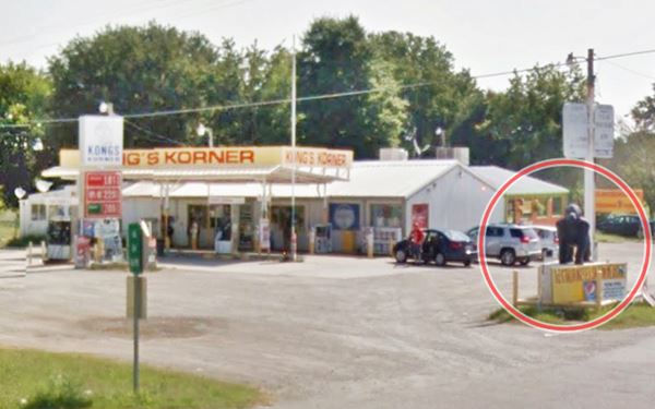
Just 0.4 miles south of the Pyle's statue, is a classic Route 66 landmark (Map with directions).
At E-430Rd and Route 66, on the eastern side of the road south of Foyil (14951 S Highway 66), is Kong Korner and Kongs Kafe Gorilla. Don't miss the gorilla statue at the junction (tip: not King sized though).

Kongs gorilla statue. Source

Kongs Korner Gas station sign. Source
The World's Largest Totem Pole
Turn around and head north to visit Foyil's most famous and kitschy attraction. It is a 5.3 mile drive (Map with directions).
Route 66 Kitsch
Listed in the National Register of Historic Places
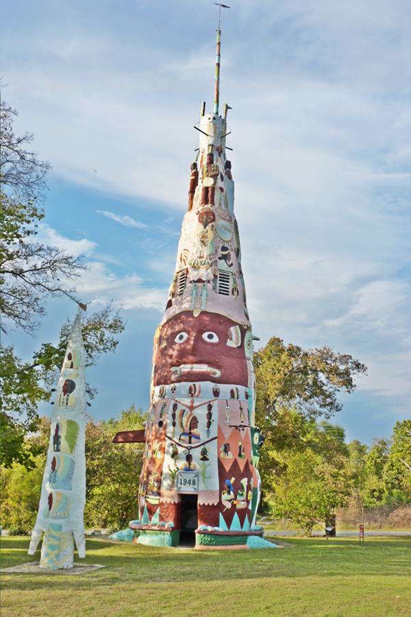
The Totem Pole Park is located at Hwy 28A, Foyil, OK. It is open during daylight hours. There is a Gift shop (918)-342-9149
The historic totem pole, completed in 1948, is 90 ft. tall and 9 ft. wide at its base.
It is the work of Nathan Edward "Ed" Galloway (1880 - 1962). He was born in Springfield Missouri and learned to carve wood as a boy and was a proficient craftsman. He worked at an orphans' home in Sand Springs, near Tulsa, Oklahoma teaching manual arts to the boys there.
He crafted violins and furniture which he displayed in his eleven-sided "Fiddle House" (built for that purpose), now it is a museum and gift shop.
Inspired by post cards and the National Geographic magazine, Galloway began working on the Totem Pole after he retired in 1937 to his 14 acre property north of Foyil. He finished his work in 1948. He did it because he wanted to have something to keep him busy and because he believed it may be an attraction for Boy Scouts to visit.
The Totem Pole has an internal structure of red sandstone framed with steel, scrap metal and wood which is covered with concrete. It is hollow, and has an internal ladder climbs the nine floors to the top of the structure.
The totem in numbers
- It is 90 feet (27 m) tall
- Its circumference is 30 feet.
- 28 tons of cement, 6 tons of steel and 100 tons of rock and sand were used to build it.
- It has 200 bas relief images
The ground floor is 9 ft. in diameter and its plastered interior is covered with painted murals. The top floor cone is open to the sky.
He did most of it himself, by putting in full work-days from sunrise to sunset. He kept on working in his other creations right up to his death.
The outer part of the structure is carved with bas-relief motifs and painted with bright colors; it depicts lizards, owls, Native American chiefs with their feather head dresses.
The base of the Totem Pole is a turtle carved from a sandstone outcrop.
There are other sculptures on Galloway's property (Totem Pole Park): birds, smaller totem poles:
The other sculptures and totems
He later (1950s) built an "Arrowhead Totem", a "Birdbath Totem" and a "Tree Totem".
There are totem picnic-tables with seats, and a totem barbeque. Bird shaped gateposts and a Fish-Arch gateway.
After his death, the Totem Pole began to deteriorate and it would take almost three decades for action to be taken: The concerted action of the Rogers County Historical Society (which bought the property in 1989), the Kansas Grass Roots Art Association, and the Foyil Heritage Association restored the sculptures and repainted them.
Is it really the largest Totem Pole?
It is the largest concrete totem pole. There are others, carved in wood, that are contenders: the 173 ft. tall (made from three sections) totem at Alert Bay, British Columbia, Canada. Also the Kalama, Washington, Chief Lalooska pole made from one single piece of wood: 140 ft. tall, but not made by Natives. And the Kake, Alaska, 132 ft. tall, which was made by natives with one single section.
About Totem Poles
The Natives along the Nortwest Coast of America carved tall red cedar poles with figures, they were known as Totem Poles.
They were crafted by Haida, Tlingit and Tshimishian people and other groups in Canada and the US.
These poles honored their families, clans and chiefs.
When you return to Route 66, to your right (you surely saw it as you turned off, when you drove to the Totem Pole Park, is a famous bar.
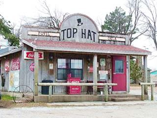
Former Top Hat now Annie's Diner Kevin, click for street view
Top Hat Dairy Bar - now Annie's Diner
Pictouresque building (from the early 1970s).
Good food, friendly staff. A place to stop and eat.
This ends your city tour in Foyil.
Some sponsored content
>> Book your Hotel in Tulsa

Credits
Banner image: Hackberry General Store, Hackberry, Arizona by Perla Eichenblat
Foyil Filling Station, National Park Service
Bob Burke, Eric Dabney, Historic Rogers County: An illustrated history, pp. 37
D. C. Gideon, 1901. Indian territory, descriptive, biographical and genealogical ... a general history of the territory, Lewis Publishing Co.
Harold "Red" Grange - Related Biography: Sports Agent Charles C. Pyle
Ed Galloway's Totem Pole Park, Foyil, Oklahoma, Route 66: A Discover Our Shared Heritage Travel Itinerary. National Park Service
George H. Shirk, Oklahoma Place Names, pp. 167.
Route 66 Map in Foyil. Oklahoma D.O.T.
Final Survey Report for the Oklahoma Route 66 Historic Resources www.okhistory.org
Jack DeVere Rittenhouse, (1946). A Guide Book to Highway 66.


