
Tiny town on US 66

Index to this page
About White Oak, Oklahoma
Facts, Trivia and useful information
Elevation: 770 ft. (230 m). Population: 210 (2025).
Time zone: Central (CST): UTC minus 6 hours. Summer (DST) CDT (UTC-5).
It is a very small village just west of Vinita, in northeastern Oklahoma. Historic Route 66 crosses the village from notheast to southwest.
White Oak's History
See Vinita, History for full information on the region's history.
White Oak is a small agricultural community. The post office opened in October 1898, and at that time there already were farmers living there, the railway passes by the western side of the small town, running parallel to Route 66.
A stagnated population led to the closure of the post office in 1957.
Today it is an unincorporated community and census-designated place (CDP) in Craig County.
The Shawnee Tribe
The Shawnee people were originally from Ohio where they were confined to reservations (1817) and relocated after the Indian Removal Act of 1830: some went to Kansas
and others to the Indian Territories in what would later become Oklahoma (1831).
After Kansas became a state in 1861, they were again removed and they migrated to Oklahoma after reaching an
agreement with the Cherokee people there by which they became citizens of that tribe and were granted land in what is now Rogers and Craig Counties, including White Oak.
It is for this reason that they are known as the "Cherokee Shawnee".
The name: White Oak
The White Oak or Quercus alba is one of eastern America's hardwood trees. It is a member of the oak family (Fagaceae), and native to the region comprised by the Atlantic Seabord to the east, southern Quebec and eastern Minnesota in the north to Florida in the South and the eastern parts of Kansas, Oklahoma and Texas in the west.
Its bark is a light gray (not white) color and that is the reason for its name. The town is on the western limit of its range. And they gave a boost to the local economy feeding the sawmills.
Route 66 passed through the town in 1926, and brought some prosperity until I-44 was completed in 1957, bypassing it.

Find your Hotel near White Oak
There are several hotels in neighboring Vinita, less than 7 miles east of White Oak. Alternatively you can also lodge in other towns along Route 66 in Oklahoma.
>> Book your Room in Vinita
More Hotels & Motels
There are several hotels in the area close to this town. Alternatively you can also find your accommodation along Route 66 in the neighboring towns and cities. We list them below (listed from east to west):
On Route 66's Main alignment
Eastwards
Westwards
> > There are two RV campgrounds close to White Oak.
Weather in White Oak

Location of White Oak on Route 66
Check the Weather and climate of Vinita for historical weather information.
Tornado Risk: White Oak lies within the "Tornado Alley in Oklahoma and experiences about 8 Tornado watches every year.
Read more about: Tornadoes on Route66.
Map of Route 66 through White Oak
See the description of this segment in our Vinita to Tulsa webpage.
The interactive map below show the alignment:
Map of this segment in this town

1948 Shell Roadmap northeast Oklahoma
Click on map to enlarge
Source
The thumbnail map (click it to enlarge) was published in 1948. It is a Shell Highway Map and it shows northeastern Oklahoma and SE Kansas. You can follow Route 66 from the upper right (Galena KS) to Claremore OK on the lower left. White Oak is in the middle (written "Whiteoak" as a single word).
Route 66 was paved from Vinita to the Rogers County line in 1933, using Portland cement. From there to Chelsea, it had been paved in 1931. The four-lane Route 66 west of Vinita ends shortly before White Oak, and was built in the early 1960s. The highway through White Oak is a two-lane roadway. The four-lane alignment begins again west of the county line.
Route 66 Alignment near White Oak
Visit our pages with old maps and plenty of information of the old US 66 roadway.
- Tulsa to Chandler (next)
- Vinita to Tulsa (White Oak's)
- KS-OK state line to Vinita (previous)
Route 66 landmarks & attractions
Sights in White Oak small town Attractions
Rittenhouse in his 1946 classic "Guidebook" to Route 66, described it as "a small hamlet with a couple of gas stations and groceries, plus a school and a few homes. No cafes, garages, courts (motels) or other accommodations here.", and it remains very much the same nowadays.
Start your city tour on the eastern side of the village. At North Main St. to your left is a "used car dealer", with some vintage jalopies (Street view).

Moose lodge some years ago, Source Click image for Street View
Moose Lodge
Ahead, on Route 66, 100 yards west of Main St. to your left. A building in ruins that at one time sported the "Moose Lodge Sign" as you can see in the image (red arrow).
The lodge is a fraternal organization, this one seems to be the #1366; and at one time the window announced "Bingo Thursdays 7:30 PM".
Native American roots: Dances, Cemetery and Ceremonies
In line with the town's Shawnee roots, it is the location of the Shawnee Tribe's ancestral annual Spring and Fall Bread Dances and Green Corn ceremonies.
Close to the village is the Little Shawnee Cemetery (Loyal Shawnee Tribe), see this map.
Sawmill
The main landmark is the Mill, just 250 yds. ahead, to your right, beyond the railroad tracks. To the southwest of the town.
Local oak wood was processed at saw-mills and used for barrel staves (the strips of wood that are used to make a barrel).


Little Tin Barn, click for Street View
Little Tin Barn
Head west from here for 1.4 miles (map) to visit a flea market cum curio store at 43305 E. Hwy. 66.
Several buildings and a vast yard full of collectibles, sculptures -of the odd type such as dinosaurs, cowboys, or dolphings; lawn ornaments and more!
Drive west towards Chelsea for 4.9 miles, and to the right is the site of a classic motel-now razed. Map with directions.
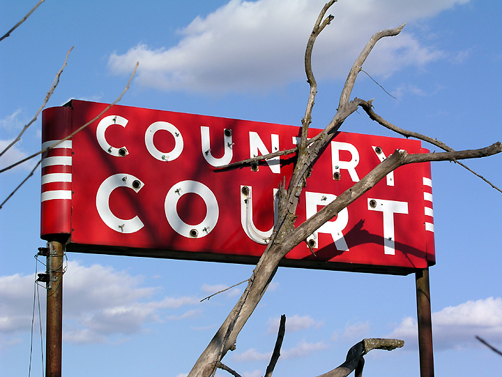
Country Court Motel
The map published in 1970 shows the cabins of the old Country Court, now only the foundations remain among the trees, the cabins were torn down.
The lovely red neon sign with white letters has also gone as you can see in these two street views: Now: sign gone, and Then: sign there.

Neon Sign Country Court, Source

1970 USGS Map and satellite view of foundations (click to see)
This ends your city tour in White Oak.
Sponsored Content

>> Book your Hotel in Vinita
Credits
Banner image: Hackberry General Store, Hackberry, Arizona by Perla Eichenblat
Jack DeVere Rittenhouse, (1946). A Guide Book to Highway 66