Route 66 at the Green-Gray River
Index to this page
- About Verdigris
- Weather
- Hotels near Verdigris
- Map of US 66 through the town
- What to see and do in Verdigris
About Verdigris, Oklahoma
Facts, Trivia and useful information
Elevation: 610 ft. (186 m). Population: 5,870 (2024).
Time zone: Central (CST): UTC minus 6 hours. Summer (DST) CDT (UTC-5).
A small town 8 miles southwest of Claremore and 4 miles north of Catoosa, in Rogers County, northeastern Oklahoma.
Historic Route 66 (OK-66) crosses the town with a notheast to southwest course.
Verdigris's History
Visit our Claremore webpage for an overview of the region's history.
French fur traders explored the Arkansas River and along its upper reaches, in the late 1700s, they discovered a river which they named Verdigris. In those days, this territory was part of the French Louisiana.
Louisiana was purchased by the USA in 1803, and what would later become Oklahoma, was initially designated as the Indian Territory. Many native groups were relocated there, evicted from their ancestral territories east of the Mississippi, during the 1830s: the Cherokee, Delaware, Ontario and Miami among other tribes.
The Cherokee Nation was assigned this territory and they settled it.
A small rural community grew along the stage coach route that followed the high ground southwest of Claremore. A post office was established at Verdigris on March 12, 1880. And a few years later, a stop of the St. Louis - San Francisco Railway which was built there.
Route 66 was aligned through the town in 1926 and re-aligned in 1936 west of Verdigris along its current roadbed, now it is Oklahoma highway 66. In 1954 the post office closed, and in 1957 the Interstate I-44 opened, leading to a drop of traffic along US-66.
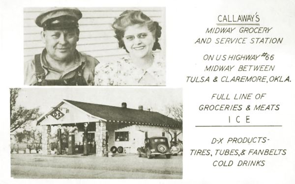
The highway was widened to a 4-lane alignment between Claremore and Tulsa County in 1957. Route 66 follows the westbound ones, and the buildings, such as Callaway's D-X station, and many others, in the path of the new eastbound lanes were torn down.

The town of Verdigris was incorporated in 1980, it is part of the Tulsa metropolitan area. It is mainly an agricultural community.
The Name Verdigris
The French traders called the river "Verdigris" after the words "Vert" (green) and "Gris" (gray), perhaps due to its "green-gray" tinted water.

Where to Stay
The towns close to Verdigris along US66 have plenty of motels.
> > Book your Motel or Hotel in neighboring <Catoosa
More accommodation near Verdigris
There are several hotels in the area close to this town. Alternatively you can also find your accommodation along Route 66 in the neighboring towns and cities. We list them below (listed from east to west):
On Route 66's Main alignment
Eastwards
Westwards
>> There are many RV campgrounds in Verdigris - Claremore.
Weather in Verdigris

Location of Verdigris on Route 66
Check the Weather and climate of Claremore for historical weather information.
The average temperature is 60°F (15.6°C), and the average rainfall is 43.4 inches (1.100 mm). A few inches of snow fall during winter.
Tornados
Tornado Risk: Verdigris lies within the "Tornado Alley in Oklahoma and experiences some 10 Tornado watches every year.
Read more about: the risk of Tornadoes on Route66.
Map of Route 66 through Verdigris
Map with the alignment of Route 66 through Verdigris
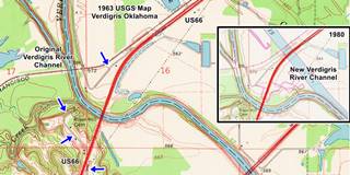
The image inset shows a USGS map with Route 66 published in 1963 and at that time the modern Verdigris River channel hadn't been built. The inset to the right shows a 1980 USGS map of the same place, where you can see the wide channel built in the 1970s.
The blue arrows mark the 1926-36 US 66 alignment in the area, and the main red colored roadway is US66, already a 4-lane highway running across the map from Verdigris (top) into Catoosa (bottom).
1926-36 segment
You can see it marked with a yellow line in this Map of the 1926-36 alignment to what is now OK-66. It was replaced when the 1936 bridge was built across the Verdigris River along the current alignment. It carried on, on the western side of the river (this Map shows the part that can be driven.
1936-57 segment
What is now OK-66, and is shown in this Map.
Route 66 Alignment in Verdigris
Visit our pages with old maps and plenty of information of the old US 66 roadway.
- Tulsa to Chandler (next)
- Vinita to Tulsa (Verdigris')
- KS-OK state line to Vinita (previous)
Route 66 landmarks & attractions
Sights in Verdigris
In his "Guide Book to Highway 66" written after he drove along Route 66 from Chicago to LA in 1946, Jack DeVere Rittenhouse tells us that 2 miles east of Verdigris there was a "Gas station and grocery", and that 3 miles west of the village, on the eastern banks of the Verdigris River (not the current one, the original river, now named Bird Creek there was a "Gas and curios at a station", surely Felix and Oscar (now gone). He also wrote a short entry describing Verdigris:
...Pop 64. Bowen's garage; gas; groceries; no tourist accommodation or cafe Jack DeVere Rittenhouse, 1946
We will start our City Tour of Verdigris on its eastern side and head west towards Catoosa. Nothing remains of the stores along US66, or Bowen's Garage. They were torn down when US66 was upgraded to a 4-lane highway. The village is on the north side of the railroad that runs parallel to Route 66. There was no space in between the tracks and the highway for buildings, so these were erected on the south side of Route 66, and in 1957 these were razed to make space for the two new eastbound lanes.
Verdigris Trivia
A short story by Kurt Vonnegut titled "Armageddon in Retrospect" has Verdigris as the headquarters of the United Nations Demonological Investigating Committee (UNDICO).
Nut House
On the western side of Verdigris, to your right at 26677 OK-66. Despite its name, it is not a lunatic assylum, it is a store that sells all kinds of nut products including locally grown pecan nuts, that opened back in the 1980s.
Verdigris River and Route 66
Two miles west of the town you will reach the modern Verdigris River Channel. It didn't exist during Route 66's golden days. It was built in the late 1960s (see the Map further up).
Verdigris River
The Verdigris river is a tributary of the Arkansas River and therefore part of the Mississippi River watershed.
Its sources are located in Kansas and its length is about 310 miles (498 km). The Tulsa port of Catoosa was built on the river just north of the town of Verdigris.
It is mentioned in the novel "Little House on the Prairie", written in 1935 by Laura Ingalls Wilder.
Tulsa Port of Catoosa
This port opened in 1970. Just north of Catoosa is the Tulsa Port of Catoosa, located at the end of the McClellan-Kerr Arkansas River Navigation System, an inland waterway that links it through the Verdigris and Arkansas Rivers to the Mississippi River and along it, to the Gulf of Mexico.
It is the first (or second behind Duluth, Minnesota according to other sources) most-inland seaport in the United States.
The port is in an industrial park and handles manufactured goods and agricultural products, exporting them to the whole world. It handles over 2.7 Million tons of cargo per year.
The waterway is ice free and its locks are managed by the U.S. Army Corps of Engineers.
New river channel
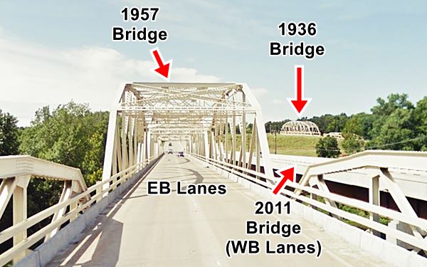
A new channel was cut, to straighten out the river, and renamed Verdigris. The original riverbed just west of it was called Bird Creek. New bridges were built to carry US66 across this new waterway, but these bridges spanning "modern" Verdigris River are not part of the original Historic Route 66 alignment through Rogers County.
Ahead are the original bridges across the original Verdigris River (now Bird Creek).
On a separate page you can read our description of all the bridges in Verdigris, and the old alignments, these bridges are pictured below.

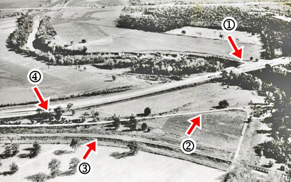
The image below is a late 1950s picture looking south towards Route 66, it shows: (1) the Verdgiris River bridges, (2) the 1925-36 Route 66 roadbed, (3) the railroad, and (4) the gas station mentioned by Rittenhouse, Felix and Oscar, located between the old and new alignments. Click on the picture to see the same view nowadays (3D satellite image).

Your trip across Verdigris ends here, head west to visit Catoosa.

Some sponsored content
>> Book your Hotel in Tulsa

Credits
Banner image: Hackberry General Store, Hackberry, Arizona by Perla Eichenblat
Jack DeVere Rittenhouse, (1946). A Guide Book to Highway 66.


