The great Cherokee
Index to this page
- About Sequoyah
- Weather
- Hotels near Sequoyah
- Map of US 66 through the town
- What to see and do in Sequoyah
About Sequoyah, Oklahoma
Facts, Trivia and useful information
Elevation: 669 ft. (204 m). Population: 671 (2000 census).
Time zone: Central (CST): UTC minus 6 hours. Summer (DST) CDT (UTC-5).
Secuoyah is a tiny town located on Route 66 in Rogers County, northeastern Oklahoma, between Chelsea and Claremore.
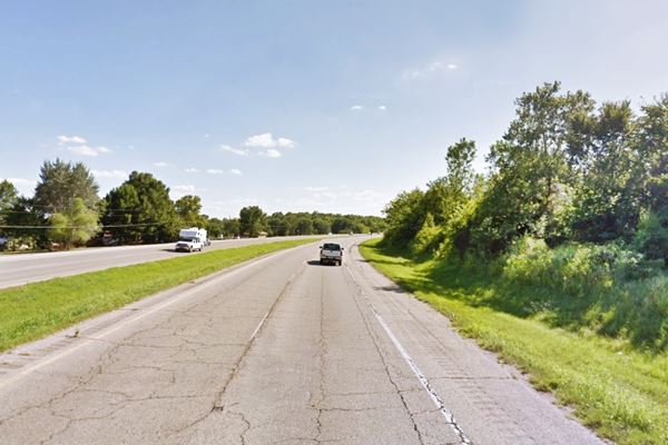
Looking west along Route 66 in Sequoyah Oklahoma

Sequoyah's History
Visit our Claremore, History section for full information on the region's history.
A post office opened at Sequoyah on August 10, 1871. Later a railway stop of the A&P railroad was built at the site.
It is said that the town changed its name to Beulah in 1909 and in 1913 it went back to the original name. Behulah was the name of the daughter of the Postmaster, Mr. Taylor. However. a Rogers County map clearly shows that Beulah was loated north of Sequoyah, and 4 miles south of Foyil.
It is a very small rural community which became part of Route 66 when the highway was created in 1926. However, even in the heyday of Route 66 it was a small hamlet.
The Name Sequoyah

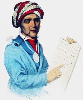
A lithograph from the portrait painted by Charles Bird King in 1828
The town's name honors Sequoya, the inventor of the Cherokee language alphabet
He was born in Tennessee, ca. 1770, the son af a white man, Nahtaniel Gist, and an Indian woman. His father abandoned them when Sequoyah was a child.
He became a silversmith and blacksmith, and was a good artist. He also devised a written alphabet for the Cherokee language which he finished in 1821.
He moved to Arkansas in 1818 and in 1828, he explored the lands in Oklahoma that the Federal government would give the Cherokee in exchange for their territories east of the Mississippi.
He then moved to what is nowadays Sequoyah County, Oklahoma. He died in Mexico in 1843 during an expedition there.
His is the first and only case of somebody who never learned to read or write and created on his own a new written language.
Sequoyah Trivia
Did you know that the gigantic redwood tree, Sequoia sempervirens is the tallest tree in the world and that the giant sequoia Sequoiadendron giganteum is the largest tree and living creature by volume? Both were named Sequoia in his honor, and so was the Sequoia National Park in California

Where to Stay: Find your hotel
There are several hotels in neighboring Vinita and Claremore near Sequoyah. Below is a list of lodging in towns along Route 66 close to it.
> > Book your Hotel in Vinita or Claremore
Find a hotel nearby
There are several hotels in the area close to this town. Alternatively you can also find your accommodation along Route 66 in the neighboring towns and cities. We list them below (listed from east to west):
On Route 66's Main alignment
Eastwards
Westwards
>> There are three RV campgrounds near Sequoyah.
Weather in Sequoyah

Location of Sequoyah on Route 66
Check the Weather and climate of Claremore for historical weather information.
Tornado Risk: Sequoyah lies within the "Tornado Alley in Oklahoma and experiences some 8 Tornado watches every year.
Read more about: the risk of Tornadoes on Route66.
Map of Route 66 through Sequoyah Oklahoma
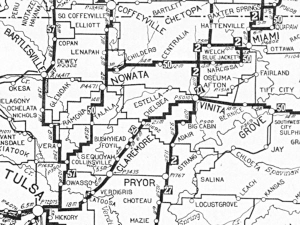
Below is a map that was published two years before Route 66 was estabilished. It marks the "car-worthy roads" or "Auto Trails" that existed before the US Highway system was created in 1926.
Sequoyah is in the middle of the map, just above Claremore. Highway "50", meaning the "Ozark Trails" passes through it. This would become Route 66 in 1926; you can follow it from Vinita (upper right corner) to Tulsa OK (on the lower right left corner).


This is the Route 66 map from Foyil to Claremore that goes through Sequoyah.
Route 66 Alignment in Sequoyah
Visit our pages with old maps and plenty of information of the old US 66 roadway.
- Tulsa to Chandler (next)
- Vinita to Tulsa (Sequoyah's)
- KS-OK state line to Vinita (previous)
Route 66 landmarks & attractions
In 1946 Jack DeVere Rittenhouse drove US 66 and published his "A Guide Book to Highway 66". In it he mentioned Sequoyah.
Listed on the maps as a 'town,' but actually consisting of a coal loader, a dozen homes, one gas station and store Rittenhouse (1946)
Nothing remains of the classic Route 66 buildings in Sequoyah, there was no space for them on the northern side of the highway (the railroad's right of way ended by Route 66), so they must have been located to the south, where the eastbound lanes were built in the 1960s.
Sequoyah Town Trivia
The town is the setting for the 2000 film Where the Heart Is, starring Ashley Judd and Natalie Portman
Head west and visit Claremore to continue your Route 66 road trip.
Some sponsored content
>> Book your Hotel in Tulsa

Credits
Banner image: Hackberry General Store, Hackberry, Arizona by Perla Eichenblat
Jack DeVere Rittenhouse, (1946). A Guide Book to Highway 66.

