Route 66 in Glendora CA
Index to this page
About Glendora California
Facts, Trivia and useful information
Elevation: 774 ft (236 m). Population 50,967 (2025).
Time zone: Pacific (MST): UTC minus 8 hours. Summer (DST) PDT (UTC-7).
Glendora is a city located on the 1926-33 and 1933-64 alignments of Route 66 in Los Angeles County in southern California on the San Gabriel Mountains' foothills; it is part of the Los Angeles metropolitan area.
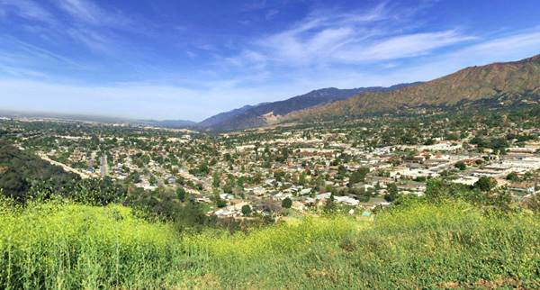
To the north lie the San Gabriel mountains, and to the south, the South Hills that reach a maximum elevation of 1,194 ft (364 m) and lie between the San Dimas Creek and Big Dalton Wash.
A view of Glendora from South Hills, looking northwest towards the San Gabriel Mountains
The History of the city of Glendora, California
This part of California has been inhabited for over 10,000 years. The Spanish explored the area in the 1600s and met the "Tongva" Native American people, which they called Gabrielino or Gabrieleño (after the San Gabriel Arcángel Mission that they established nearby in 1771).
The Mission owned a vast area of land which after Mexico became independent from Spain in 1821 was carved up and granted to local citizens during the "secularization" process that divested the Catholic Church's land holdings.
The Mexican Governor Juan Bautista Alvarado granted part of this land in 1837 to Ygnacio Palomares and to Ricardo Vejar who formed the 15,000 acre "Rancho San José" that included what nowadays is San Dimas, Covina, Walnut, Azusa, Glendora, La Verne, Claremont and Pomona.
After Mexico lost California (and the other Southwestern states) to the U.S. during 1846-48 war, it became a state of the Union in 1850, and following the death of Palomares (1864), and Vejar's bankruptcy, the land was sold to other investors like George Whitcomb, a wealthy Illinois business man.
Two former Civil War soldiers also settled there in 1874, John Bender and Bryant Cullen, staking their homesteads. In San Gabriel valley.
In the meantime, a subsidiary of the Santa Fe Railroad, the Atlantic & Pacific Railroad, linked the line that crossed the U.S from the Mississippi River to a new line built in 1887 from San Bernardino across the San Gabriel Valley and into Los Angeles.
The railroad and the development speculation of the mid 1880s led Whitcomb to develop a townsite and a surrounding agricultural community, which by the early 1900s had become a center of the citrus industry. Glendora incorporated as a city in 1911.
The Name: Glendora
George Whitcomb created the name by blending the word "Glen" (a long deep valley) with his wife's name "Leadora" (Leadora Bennett Whitcomb), which is a Greek name "Eleodora" meaning "she who came from the Sun".
The USGS survey along the Santa Fe railroad of 1915 says the following about the town and its surroundings: "... From Glendora to Azusa and in a wide area on the south are numerous orange groves and other orchards, most of them irrigated by canals from San Gabriel River, which comes out of a Large canyvon a few miles to the northwest. Pumping plants also add to the supply for there is considerable water in the sand and gravel under the plain. Near Azusa the railway is within a mile of the foot of the steep southern front of the San Gabriel Mountains, which has been followed all the way west from the mouth of Cajon Canyon and continues to Los Angeles."
The main throughfare in town at that time was E Foothill Blvd. that ran with a straight east-west alignment, on the eastern side of town it met the foothills of the mountains by Morgan and Canyons and turned sharply southwards along what Amelia Ave. and ran along the foothills with a NW-SE along Foothill towards San Dimas. The National Old Trails (N.O.T.) highway, created in the 1910s to link Los Angeles with New York followed this alignment.
Glendora's slogan Pride of the Foothills was was coined by Flora Jones Seaman Webb in the early 1900s for the local newspaper, the Glendora Gleaner. The picture below was taken at that time, notice the gateway with "Glendora" written on it. This is the same view nowadays. The City Hall on the right is still standing.
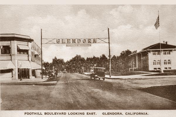
In 1926 Route 66 was created and it was aligned using the N.O.T. highway in California. It ran along Foothill Blvd. into Glendora. When the flood-prevention dams were built in the mountains, Route 66 was realigned (1933) along a new roadway (Alosta Ave.) on the south side of town, with a straighter course (Read more below).
The expansion of Los Angeles metropolitan area after the mid 1950s, soon reached Glendora that became part of the urban sprawl. The growing freeway system moved traffic away from Route 66. Glendora ceased being on the Mother Road when the western terminus of Route 66 was moved to Needles in 1972 in Western California.

Accommodation in Glendora
You can find your room in Glendora and in neighboring towns.
> > Book your Hotel in neighboring Monrovia
More Lodging near Glendora along Route 66
Below you will find a list some of the towns along Route 66 east and west of Glendora; click on any of the links to find your hotel in these towns.
>> Check out the RV campground near Glendora, in Pomona
The Weather in Glendora
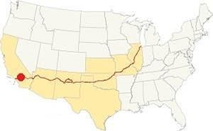
Location of Glendora on Route 66
The weather in Glendora is warm Mediterranean one; it is semi-arid, with hot and dry summers and cool - chilly winters.
The town has an average of 289 sunny days yearly. During fall the strong hot and dry Santa Ana wind blows from the desert, through Cajon Pass increasing the risk of wildfires the San Gabriel Mountain foothill communities.
During summer the average high is 90°F (32°C) and the average low is 62°F (17°C). During winter, the average high (Jan) is around 68°F (20°C) and the average low is 43°F (6°C). The peaks of the San Gabriel Mountains receive plent of snow, but none falls on Route 66 in Glendora.
Rainfall averages 18.2 in. per year (461 mm), with the period May to September being the driest one with less than 0.3 in. monthly (8.4 mm) and mostly 0.01 in (0.3 mm).
Tornado risk
Glendora is located very close to the Pacific Ocean and well beyond the Rocky Mountains (western limit for tornadoes) so there is no risk of tornadoes in town.
Tornado Risk: read more about Tornado Risk along Route 66.
Wildfires
The "Colby Fire" in Glendora lasted for 9 days in January 2014 and burned 1,992 acres fanned by the Santa Ana winds, 5 homes were burned and it led to the evacuation of 3,600 people. Wildfires are not common during winter, but a dry season led to an excess of dry brush in the foothills which later fed the fire.
Map of Route 66 in Glendora
>> Custom map of Route 66 through Glendora.
National Old Trails Highway (N.O.T.) in Glendora
By 1915, use of the automobile had grown greatly and the National Old Trails (N.O.T.) Association had been formed to promote a highway link between Los Angeles and New York. In California, Arizona and New Mexico the road was built running close to the Santa Fe railway. In 1912 map by the Automobile Club of Southern California published a map which shows the highway running from through Glendora, crossing the tracks there (28 mi.) and then going throughAzusa (26 mi. from LA), where it crossed the S. Fe railroad again.
Route 66
There were two alignments of U.S. Highway 66 across Glendora. The first one dates back to 1926, when the highway was created. It follows the alignment of the N.O.T. roadway. The following map was published in 1927, one year after Route 66 was born. It shows the highway all the way from Victorville in the east, through San Bernardino and then westwards into Los Angeles; you can see Glendora in it.
>> pale blue line is the 1926-33 alignment of US 66 in Glendora.

1927 Road map, SW CA
Click on image to enlarge.
Credits

1956 Shell Roadmap, SW CA
Click on image to enlarge.
Credits
Driving east to west, coming from San Dimas, the original Route 66 along E Foothill Blvd. took a sharp right curve heading north along Amelia Ave. and then, another sharp turn left along E. Foothill Blvd. The road then headed west, went through the center of Glendora and then took a left on N Citrus Avenue - which marks the boundary with the city of Azusa - known in those days as Dalton) where it headed west once again along Foothill until meeting Alosta Ave. (coming from the southeast, which later became the newer alignment of Route 66).
New alignment from 1933 to 1964
>> red line is the 1933-64 alignment across Glendora.

Detail 1930 roadmap
Click on image to enlarge.
Full map
The USGS map from 1939 (click on it to enlarge it) shows the first alignment along E Foothill and the later one, along Alosta Ave., further south. It avoided the sharp 90° turns and the grade crossing of the Santa Fe tracks in downtown Glendora (an underpass was built on the new alignment). Construction had to wait for the dams and hydraulic works to be completed in the Mountains, to make San Dimas and Big Dalton washes controlled streams that could be bridged.
The new roadway kept west along the brand new Alosta Ave., and after crossing Barranca Ave. entered Azusa where both old and new alignments met at the junction of Foothill Blvd and Alosta Ave. The black and white 1930 thumbnail map shows the alignment of Route 66 from Victorville to Los Angeles, it shows Glendora.
The final map further up, shows the same area in 1956; a freeway now links Victorville with Cajon and San Bernardino with Los Angeles.
In the 1950s, the freeway system in LA would start to divert traffic away from Route 66. In 1964, Route 66 was replaced by the freeway and traffic along Foothill Blvd. dwindled.
Route 66 Alignment near Glendora
With maps and full information on the Mother Road.
- Pasadena to Santa Monica (Next)
- Barstow to Pasadena (Glendora's)
- Topock to Barstow (Previous)
Glendora's Sights and Attractions
Landmarks and Classic US 66
Historic Context
The "Guide to the Golden State" written by the WPA and published in 1939, described Glendora as follows:
GLENDORA, 25.9 m. (776 alt., 2,761 pop.) another citrus-packing community, was founded in 1887 by George Whitcomb, a Chicago manufacturer, who coined the name from the word "glen" and his wife's name, "Ledora." The first commercial orange grove here, planted by John Cook in 1866, is still productive. WPA (1939)
A few years later in 1946, Jack DeVere Rittenhouse drove the whole of Route 66 and wrote his "Guide Book to Highway 66" in which he points out that the towns here "... are so close together as to be practically indistinguishable from each other..." adding "More towns you pass through include LA VERNE at 336 mi., GLENDORA, 241 mi.; AZUSA, 343 mi...." and did not add any other information.
Glendora and its Route 66 attractions
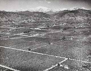
Glendora in 1941. Click image to enlarge. Source
Driving west from San Dimas it is hard to believe that this densely built-up area was once open countryside with orange and lemon groves, orchards and fields as shown in the 1941 aerial photograph (click on the image to enlarge it).
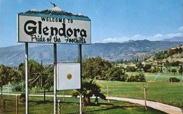
On the eastern side of the city is Glendora Country Club, created in 1954 on the former ranch of Charles C. Warren. It has an 18-hole golf course. The image below shows the "Welcome to Glendora" sign that stood there, on Route 66 at the eastern tip of the club (Same view nowadays).
1⁄3 mile ahead, to your right is the 1926-33 Route 66 alignment along Amelia Ave. and E Foothill Blvd. into Glendora (right). There are no surviving Route 66 attractions along this alignment; the 1949 telephone directory mentions the Glen Oaks Auto Park at 1456 E Foothill, which has vanished.
Below is a view of what it looked like along it in 1934 at N Loraine Ave. and Footill Blvd., notice the fruit stand to the left. See the same view nowadays; quite a contrast. Even as late as 1950, the first buildings appeared five blocks east of Glendora Ave. the rest was an area of arange groves and orchards.
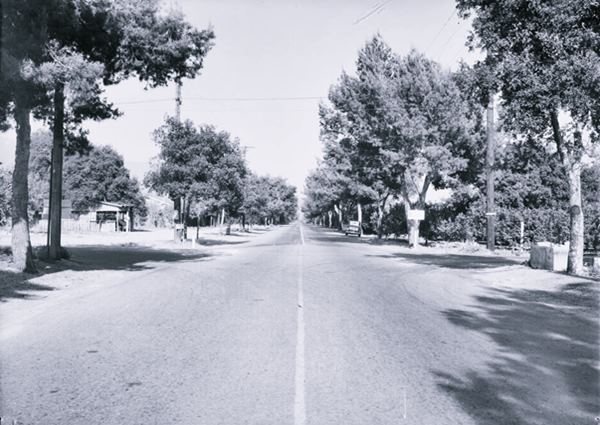
West of Amelia is the 1933-64 alignment of Route 66. It was built once the issues caused by flooding due to heavy rainfall in the San Gabriel mountains had been solved. This required the construction of a dam on San Dimas Wash and another on Big Dalton Creek 4 miles to the northeast of Glendora; it was completed in 1929 and controls flooding as well as conserving water. These works cleared the way for using a straight alignment between La Verne and Azusa.
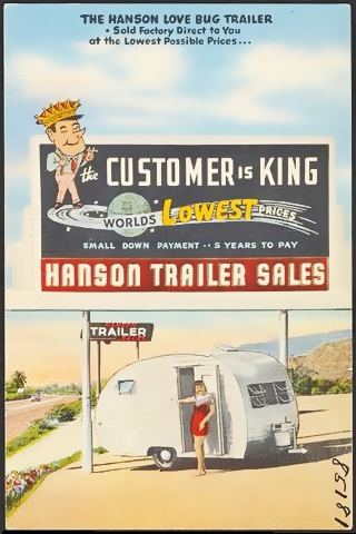
Hanson Trailer 1950s postcard, Glendora. Source
Hanson Trailer Sales
Roughly 1⁄4 mile west of Amelia Ave., to your left was a famous trailer manufacturer.
Hanson Trailer Sales was created in 1948 by Henry M. Hanson Sr.; his company built a tiny "Love Bug" trailer and larger coaches at his factory here at 2015 E Alosta.
Hanson had branch offices in Pasadena, Palm Springs, Elmonte and Long Beach. In 1958 he sold the business to Kenskill Traoñers.
The Model 10, a 10-foot trailer cost $99 down and one payment of $635 or 36 monthly installments of $27.90; adjusted by inflation this would be equivalent to $8,605 in 2024. 1
The highway was realigned along Alosta Ave. by paving a dirt trail with a SE-NW course till it reached the base of the South Hil, where it turned west.
The 1949 phone directory mentions
the now gone Howard Ramsey's Lone Hill Texaco Service at 1861 E Alosta (on the NE corner with Lone Hill Ave.), and there was a station there until recently.
Underpass on Route 66
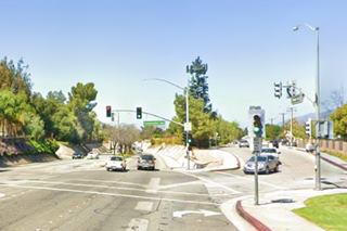
An underpass was built here to avoid the former grade crossing at Compromise Line Rd and S Valley Center Ave. The underpass was completed in 1932. Pictured below, looking west. Compromise Line Rd. can be seen to the right, behind the tree. The color image is the current view at the same spot. Big wash was moved to a new channel further west to avoid flood issues with the underpass.
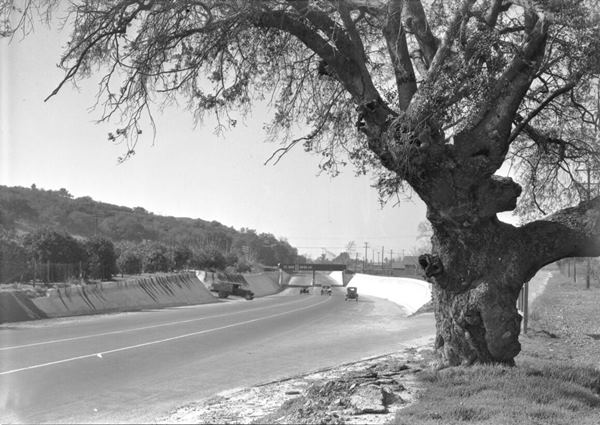
Recently a second bridge has been added here for the 12.3-mile Glendora-to-Montclair extension of the Metro Gold Line.
West of the underpass, you reach the south side of Glendora and the motels, diners and gas stations (most of them long gone), that catered to travelers.
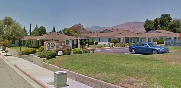
Twentieth Century Motel
It appears in the 1949 phone directory at 1345 E Alosta Ave (Route 66). It postcard called it "Motor Hotel" it is still open, as the 20th Century Motor Lodge.
The 20th Century Motel in a 1940s postcard
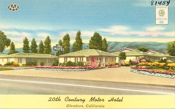
It had separate hip roofed buildings, and in the 1950s offered "heated Swimming Pool, Lanai Games and Play Areas... Panelray Heat, Radios, Television... Closed Garages...(See our Bridal Sites)."
Golden Spur Restaurant (closed)
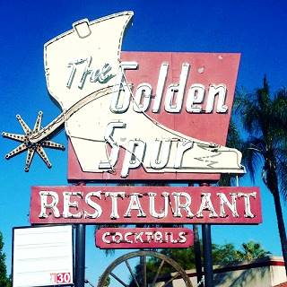
To your right at 1223 E. Route 66. This restaurant has been here for over 80 years. It's name hints at its origin, a hamburger stand that served meals to horse riders. Until it closed in 2019, it also sold steaks and seafood. Now it is a facility for disabled adults.
The best part is the neon sign, that can be seen on the ground, removed from its original position facing the highway. Surely it will be sold and lost for good. It is a classic from the 1950s, with its boot sporting a large spur.
Ahead to your left at 1046 E Alosta was Oscar W. Prussell's Trailer Park followed by the Bungalow Motel to your right at 947 E Alosta. Both have been torn down.
Motor Park, Gilpin's and Town House Motel
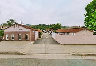
There were four motels mentioned in the 1949 telephone directory on the 800's block and two have survived. The Glendora Lodge at 831 E Alosta has gone, but the one at 826 E Alosta owned by Milblrandt William H. here at what now is the Alosta Mobile Park is still there. Pictured below.
Then came Gilpin's Motel Apartments at 818 E Alosta. Pictured above with two lineal sets of units on each side of a central driveway.
The other motel on the block was the Town House Motel at 800 E Alosta it was torn down in the mid 1980s. Finally, across the street, at 801 E Alosta was Bissontte & Champion Chevron Service Station.
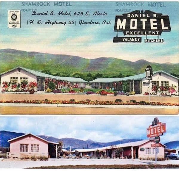
Daniel B Motor Inn ⁄ Shamrock (gone)
This place appeared in the 1948 aerial photographs and in the 1949 phone book as the "Daniel B Motor Inn" at 625 E Alosta. The motel later changed its name to Shamrock that was "A new, 16 unit, ultra modern, fire-proof, motel with full-tile baths; fully carpeted; de luxe kitchenettes; free television in rooms; 15 minutes to Santa Anita; 20 minutes to Pasadena; 40 minutes to Los Angeles; “Ideal vacation headquarters”."
It was torn down in the mid 2000s and the Best Western Route 66 Glendora Inn now stands on the property.
There were two additional motels along East Alosta; Bo Peep Motel at 445 E Alosta with only six units, owned by O. L. Stephens and one operated by Herbert S. Zadach at 205 E Alosta. Both torn down.
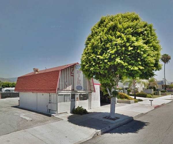
Alta Dena Dairy
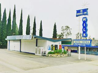
To your right at 437 E Alosta, this is a building that appears in the early 1960s aerial photographs. The Alta-Dena Dairy was founded in 1945 in Monrovia by three brothers of the Stueve Family, and they became a "certified dairy" in 1953. This used to be one of their stores. There is another Altadena store with an amazing googie style, on W. Foothill (the 1926-33 alignment of Route 66) in downtown Glendora
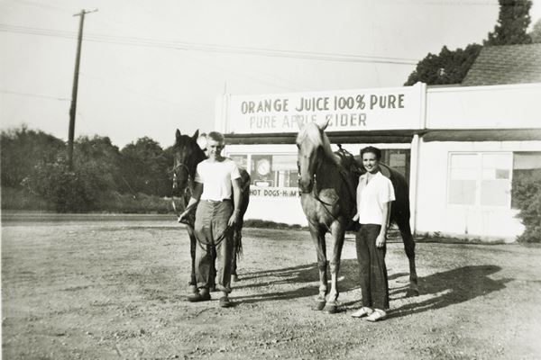
Main crossroads
Ahead is Glendora Ave. the main street running north into Glendora; its original name was Michigan Ave. Below is a view of the crosrroads in 1946, it was surrounded by orange groves and orchards. There is an orange juice and apple cider and hot dog stand behind the two people in the picture. You can see the building on the SW corner in this aerial photo taken in 1948.
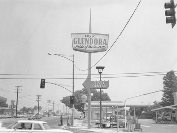
Roughly fifteen years later, there was a "City of Glendora - Pride of the Foothills" sign on that same corner. Notice the 1961 Chevrolet Biscayne, two door, flat top car driving by the ranch styled Shell service station.
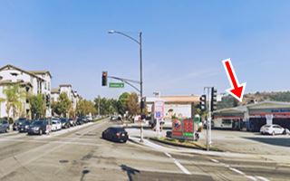
In 1957 Shell launched the ranch style service station, it had a residential look, brick veneer, a large two-part gable roof, with one part covering the three service bays and, the other, the office. They had a brick-faced chimney-like extension on the roof with the company logo that can be seen on the far right side of the image below. Now (click on image for street view), the red arrow shows the same building, but the chimney is gone and the building is a Union 76 station.
Route 66 returns to life
Glendora was the first city in California to change the name of its main street - which until 1964 was U.S. highway 66 and also known as Alosta Avenue, back to Route 66.
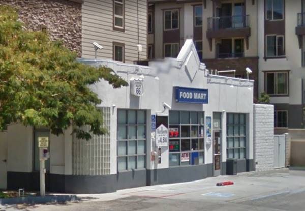
Across Alosta, on the NE corner is a modern classic station.
Vintage US Gas service station
The building at the back of the property is an original Route 66 gas station. Although it now has a modern canopy, the food mart and cashier is an Art Deco styled building with neat geometric lines that appears in the 1950s aerial photos but not in the 1949 phone book.
On the SW corner, the 1948 phone directory mentions the now gone Ideal Mobile Service at 100 W Alosta.
Downtown Glendora
One-half mile north along S Glendora Ave. is where Foothill Blvd (the 1926-33 Route 66) reached the downtown district of Glendora (map with directions.)
To your right, at the crossroads is the City Hall built in 1922 with a red tile roof topping a Spanish style building.
1949 phone directory mentions several filling stations along it as it headed west: Russell's Union Service (133 W Foothill), Sisson Associated Service Station (202 W Foothill), Foothill Service Station & Garage (406 W Foothill) and Guffey's Service (858 W Foothill). All of them gone. Turning left along Foothill, there is a classic Googie styled building.
Googie-styled Alta Dena Store
To your left, at 408 W Foothill Blvd. this store has a roof with gull wings and an amazing neon sign topped by a star with panels in blue and white. It has been here since the early 1960s according to the aerial photographs.
Googie style, pronounced "gu:gi", was a "modern" building design inspired in the Atomic and Space ages. It had geometric shapes, sweeping structures suggesting movement such as stars, atoms, boomerangs, wing shapes, and disks. It appeared in California in the late 1940s and was popular until the mid 1960s.
West Alosta Ave (Route 66)
Retrace your steps back to the 1933-64 Route 66 and drive west. The 1949 telephone directory mentions several motels along it, and some have survived. On the SW corner with S Vermont Ave. in the 1950s stood the now gone Spotless Clearners (308 W Alosta) offering"Low, low prices - Pants 5¢ - Suits $1 - Complete Family Laundry Service."
Next to it was the Dun Rovin Motel (330 W Alosta) where the Glendora Motel now stands. West of it were the Magnolia Trailer Park (422 W Alosta) and Sundeck Motor Lodge (444 W Alosta) and across the street was Welshans Motel (415 W Alosta); all of them gone except for the Glendora Motel.
Hickory Inn - Derby (gone)
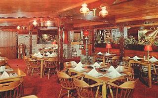
On the NE corner with Grand Ave was Hichory Inn. Walt Wiley had a fruit stand here in 1937 and Homer and Opal Weimer turned it into a resaurant in 1949 that offered "genuine hickory smoked brick oven cookery in a pleasant old English atmosphere." It closed in the 1980s and was replaced in the early 1990s by a branch of The Derby, a famous restaurant on Route 66 nearby, in Arcadia CA. It was torn down in the early 2000s. Now a Walgreen's stands on the corner.
The Hat Pastrami
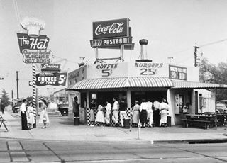
1st The Hat, 1951, Los Angeles CA. Source. Click image to enlarge.
To your right, at 611 W Route 66
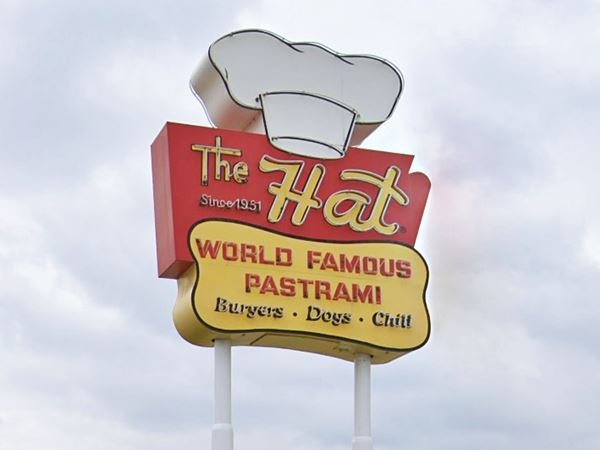
The Hat began in 1951 in Los Angeles and gradually expanded across the region. This diner opened on Route 66 in the early 1960s and is still going strong with its pastrami sandwiches. Don't miss the retro neon sign, which is a replica of the original one. Notice the prices back in 1951: Coffee 5¢ - Burgers 25¢!
Palm Tropics Motel
Next to The Hat, at 619 W. Route 66
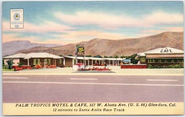
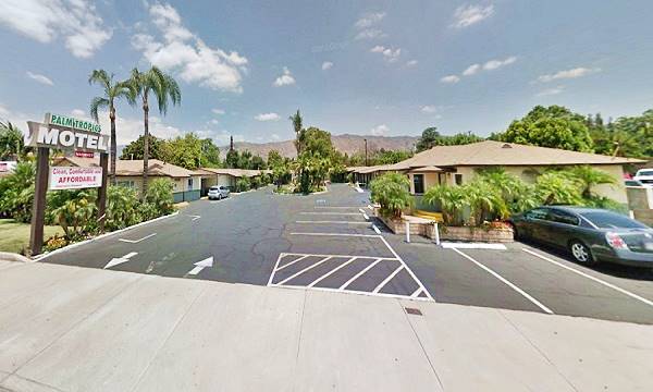
The 1949 phone book listed Blaul Robert - Palm Tropics Motel at 557 W Alosta, the numbers have changed because the motel is now numbered 617 W Alosta. West of it, in the 1950s there were no more buildings. There were only citrus groves and orchards. The postcard below also places the Palm Tropics Motel & Cafe at 557 W Alosta Ave.; "12 minutes to Santa Anita Race Track - A new, elegantly furnished fully-carpeted motel with singles, doubles and Pullman equipped kitchenetes. Full-tile baths, Panelray heat, radios. Excellent Cafe, in Connection - open Early and Late." It is still open, well maintained and receiving guests.
The Palm Tropics Motel and Cafe in a 1940s postcard
It seems to have kept its original apparance, the palms have grown to full size, and the old sign that stood in the middle of the entrance was moved to one side and replaced by a "modern" sign.
Across the street at 606 W Alosta is the Garden Inn Suites built in 1980, after Route 66 stopped running along Alosta. The Liquor Store ("La Tienda" - "The Shop" in Spanish) has been there far longer, at least since 1953.
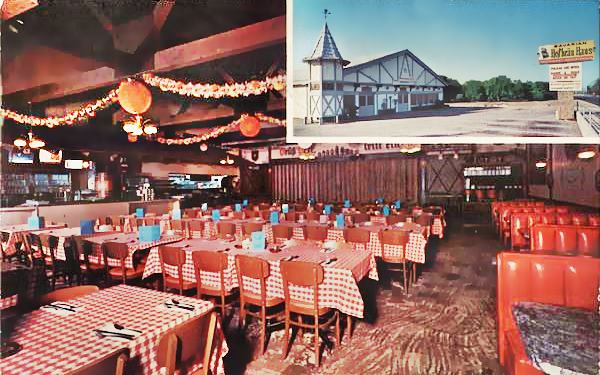
The Bavarian Hofbräu Haus (gone)
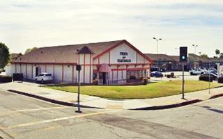
On the SE corner with Vecino Dr., where the Wendy's now stands, there once was a classic beer house between the early 1960s and 2022. Its postcard from 1965 shown below stated: "“German and American Restaurant” Famous for our buffet and stuttgart sandwiches... and delicatessen featuring German sausages, 10 different beers on tap." Before closing it was a Deli and sold fruits and vegetables. The turret, scaled down, was still there on the buildings NE tip.
Events
Flashback to the '50s Classic Car and Motorcycle Show
This is a end-of-summer party, which consists of a great car show with a broad selection of classic cars, motorcycles, trucks and also hotrods. They line Glendora Avenue and there is live entertainment, food and beverages (beer and wine). Read more at www.flashbackinfo.org.
Continue your Road Trip
Your Glendora leg of your Route 66 road trip ends here. Head west along Alosta to continue your journey and visit the next town along the highway: Azusa.

Sponsored Content
>> Book your Hotel in Santa Monica

Credits
Banner image: Hackberry General Store, Hackberry, Arizona by Perla Eichenblat
A Guide to the Golden State; Federal Writers' Project of the Works Progress Administration, Hastings House, New York, 1939.
Jack DeVere Rittenhouse, (1946). A Guide Book to Highway 66.


