Route 66 in La Verne CA
Index to this page
About La Verne California
Facts, Trivia and useful information
Elevation: 1,060 ft (323 m). Population 30,480 (2025).
Time zone: Pacific (MST): UTC minus 8 hours. Summer (DST) PDT (UTC-7).
La Verne is a small city located on old Route 66 in Los Angeles County in southern California and is part of the Los Angeles metropolitan area.
The History of the city of La Verne, California
For the early history of the area, read the History of Rancho Cucamonga because what is now La Verne was open ranch land until 1886. The Mexican Governor Juan Bautista Alvarado granted 15,000 acres of land to Ygnacio Palomares in 1837; this land spanned Pomona, Claremont, Glendora, and La Verne it was named "Rancho San José". Palomares later gave his nephew Jose Dolores Palomares a plot of his vast ranch. The historic Carrion adobe house was built there in 1868.
The current townsite was laid out by Isaac Wilson Lord a wealthy Los Angeles entrepreneur who had purchased part of the San Jose Ranch in the early 1880s. In 1886, the future town was named "Lordsburg" after him.
It was founded in 1887 on the Santa Fe Railroad that had acquired a railway line from San Bernardino to Pasadena that year to complete is link from the Midwest to Los Angeles. Counting on visitors and travelers, Lord built a 60-room hotel, that never lodged a single paying guest.
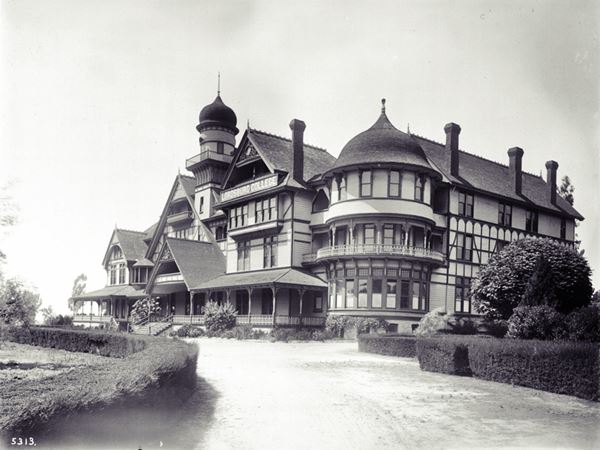
Speculators bought land, but real settlers did not show up. Lord's hotel went broke and in 1889 and the investors agreed to sell out and cut their losses, so they invited the Church of the Bretheren to visit the area and Mr. M. Eshelman purchased the bankrupt hotel and 100 city lots. The hotel was used to house their college, the University of La Verne which opened in 1891, pictured below.
The name: La Verne
The Bixby family, ranchers living in the foothills on the north side of town, used the name "La Verne" for that area, as it was green and "spring-like". The word has a Gaulish origin and means "alder" -a type of birch tree. Maybe related to the Latin word vernus that means "of spring".
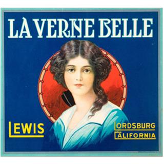
La Verne Belle oranges brand, 1910s. Source
The Bixbys formed a land development company and named it La Verne. The community incorporated in 1906 and tried to change its name in 1912 but Isaac Lord, who still owned land there, objected and it remained "Lordsburg." Only after his death in 1917 did the citizens vote to change the name to La Verne.
The image shows a citrus brand of that period and it is named La Verne Belle, but the city figures as Lordsburg.
The Church of the Brethren
This Protestant group originated in Europe in 1708. Persecution led them to migrate to America between 1719 and 1740. By the mid-1800s they had expanded west. There they split into different groups. One of them based in Kansas. In the 1890s Many Brethren moved into Lordsburg. They were also known as Dunkards.
The USGS survey along the Santa Fe railroad of 1915 says the following about this area "...West of Claremont a spur of the San Gabriel Mountains on the north extends nearer to the railway, and the San Jose Hills, a northern extension of the Santa Ana Mountains, approach from the south. Owing to these conditions the valley narrows to about 3 miles at Lordsburg. In order to pass the San Jose Hills the railway has been deflected to the northwest, a course that soon takes itnear the foot of the San Gabriel Mountains, which are closely skirted from San Dimas to Pasadena. Lordsburg was originally a Dunkard settlement. It has numerous orange and lemon groves."
By 1915, use of cars on the roads in California had grown considerably and the National Old Trails (N.O.T.) Association had advanced with their project for a highway linking Los Angeles and New York. This road followed the Santa Fe railroad tracks from California into Arizona and New Mexico. It was aligned along Foothill Blvd. in La Verne. In 1926, the N.O.T. road was incorporated into the brand new U.S. Highway 66. The road was slowly widened and improved. La Verne was a farming community, growing citrus for many years, its moniker was the "Heart of the Orange Empire" and it did not have any motels recommended by the AAA during the 1940s and 50s. After World War II, citrus farming declined and the groves were uprooted for development and subdivision. It is still a college town community.
During the 1950s, the LA freeway system grew and diverted traffic away from Route 66 which was replaced here as a major highyway around 1964 by I-10; traffic along Foothill Blvd. dwindled.

Accommodation in La Verne
You can find your room in neighboring Pomona or San Dimas.
> > Book your Hotel in neighboring Pomona
More Lodging near La Verne along Route 66
Below you will find a list some of the towns along Route 66 east and west of La Verne; click on any of the links to find your hotel in these towns.
>> Check out the RV campground nearby, in Pomona
The Weather in La Verne
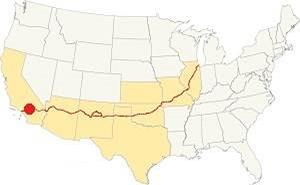
Location of La Verne on Route 66
The weather in La Verne is warm Mediterranean one. This means that it is semi-arid, and has hot and dry summers with cool & chilly winters.
The town has on average, 287 sunny days per year and the strong dry - hot Santa Ana wind blows through Cajon Pass during fall drying out the area and increasing the risk of wildfires the foothill communities.
During winter, the average high is (Jan) 68°F (20°C) and the average low is 43°F (6°C). During summer the average high is 90°F (32°C) and the average low is 62°F (17°C).
Rainfall averages 17.3 in. per year (440 mm), with the period May to September being the driest one with less than 0.2 in. monthly (5 mm).
During winter the peaks of the San Gabriel Mountains receive plenty of snow, but none falls on Route 66 in La Verne.
Tornado risk
As La Verne is located west of the Rocky Mountains that mark the western limit for tornadoes so th risk of tornadoes striking this region is almost nil.
Tornado Risk: read more about Tornado Risk along Route66.
Map of Route 66 in La Verne
>> Custom map of Route 66 through La Verne.
National Old Trails Highway (N.O.T.) in La Verne
As mentioned further up, in the 1910s the use of the automobile had increased and was becoming popular. However, there were no decent highways to drive on. So different groups were formed to lobby and promote the construction of good roads. One of them, the National Old Trails (N.O.T.) Association aimed at linking New York with Los Angeles. They built and placed signs along the dirt trail that ran along Foothill Blvd. It was improved over the years, widened and paved. The alignment in this area ran close to the Santa Fe railroad tracks. It was aligned along the north side of La Verne on Foothill Blvd.
Route 66
The N.O.T. highway became the first alignment of U.S. Highway 66 when it was created in 1926. The map below was published one year later (1927) and you can follow Route 66 from Victorville through Cajon, San Bernardino and then into Los Angeles; La Verne does not appear in this map, it lies between Glendora and Claremont.

1927 Road map, SW CA
Click on image to enlarge.
Credits

1956 Shell Roadmap, SW CA
Click on image to enlarge.
Credits
1930s Realignment
>> orange line is the 1926-30s alignment in West La Verne and San Dimas.

Detail 1930 roadmap
Click on image to enlarge.
Full map
The USGS map from 1928 (click on it to enlarge it) shows that Route 66 had a different course west of the intersection of Baseline Rd. and Footill Blvd. on the western edge of La Verne. Route 66 curved at this point leaving its SE-NW course and headed with a straight west direction along E Baseline Rd. up to N San Dimas Rd. where it turned sharply north, crossed San Dimas Wash, and then followed the SE-NW course of Foothill Blvd.
But the highway was realigned to avoid all these sharp turns when a new alignment was built to span the gap and extend Foothill Blvd. across San Dimas Wash here in the early 1930s.
The black and white 1930 thumbnail map shows the alignment of Route 66 from Victorville to Los Angeles, La Verne does not figure in this map (west of Claremont).
The final map further up, shows the same area in 1956; a freeway now links Victorville with Cajon and San Bernardino with Los Angeles.
In the 1950s, the freeway system in LA would start to divert traffic away from Route 66. In 1964, Route 66 was replaced by the freeway and traffic along Foothill Blvd. dwindled.
Route 66 Alignment near La Verne
With maps and full information on the Mother Road.
- Pasadena to Santa Monica (Next)
- Barstow to Pasadena (La Verne's)
- Topock to Barstow (Previous)

Sights and Attractions in La Verne, California
What to Do, Places to See
Historic Context
The 1939 the "Guide to the Golden State" written by the WPA described the town of La Verne as follows:
LA VERNE, 21.4 m. (1,050 alt., 2,860 pop.), is a citrus-packing center. Retail stores depend heavily on the patronage of LA VERNE COLLEGE students. La Verne originated as Lordsburg during the 1890 land boom. When the bubble burst, the promoters found themselves burdened with a $75,000 three-story hotel. In 1891 the Santa Fe Railway induced new settlers to come to the region, among them a group of Dunkards who later bought the hotel and founded Lordsburg College. In 1916, when the town changed its name to La Verne, the college did likewise. It is a co-educational institution with an enrollment of 250. WPA (1939)
In 1946, Jack DeVere Rittenhouse drove the whole of Route 66 and wrote "A Guide Book to Highway 66". In it he pointed out that the towns in this area "... are so close together as to be practically indistinguishable from each other..." adding "More towns you pass through include LA VERNE at 336 mi., GLENDORA, 241 mi.; AZUSA, 343 mi., DUARTE...", so La Verne was just one among many small towns.
Road Trip Leg: Route 66 in La Verne
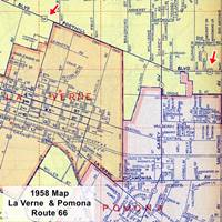
Detail 1956 roadmap of La Verne and Pomona
Click on image to enlarge.
Full map
We will begin this leg of our road trip across La Verne driving west from Pomona along Foothill Blvd. As you can see in the 1956 map (click on it to enlarge it), most of this area was unincorporated farmland (pale yellow). What is now Pomona and La Verne differs from those of Route 66's heyday. West of Thompson Wash, the north side of the highway is part of La Verne, and after 450 W Foothill, the south side also becomes part of Laverne.
The view, towards the north is great, you can see the San Gabriel Mountains and the outstanding peak of Mount Baldy (actually Mount San Antonio) which is the highest point of the San Gabriel Mountains, elevation: 10,062 ft. ( 3,069 m). These mountains are covered in snow during winter.
La Paloma (formerly Wilson's)
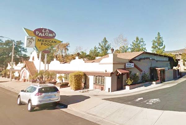
The first stop is just ahead, at 2975 Foothill Blvd. on the NW corner with Williams Ave. (right); thi classic Mexican Restaurant has very old roots on Route 66.
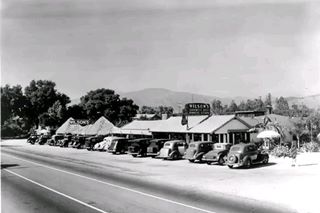
It is the oldest restaurant in La Verne and began in the late 1920s when Harry Dwight Wilson (1876-1945) and his wife Cora Belle (1886-1959) bought Kinsey Roberts organge grove. They renamed Robert's roadside orange fruit stand "Wilson's Fruit Stand" and sold goods to those driving by. Cora cooked breakfast for farm workers and it was a success. Soon they built a bungalow parallel to the highway; it was 1930, and "Wilson's Sandwich Shop" had been born. Below is a view of their shop from that period.
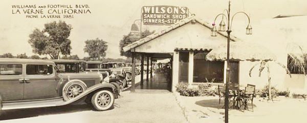
The Wilson's Sandwich Shop in a 1930s postcard
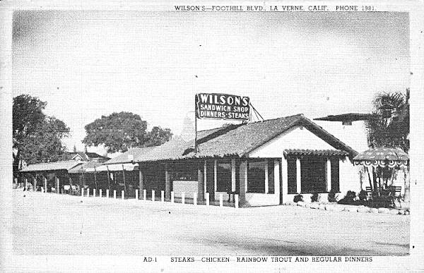
They also offered dinners and "steaks - chicken - rainbow trout"so their business evolved into a restaurant where Harry worked until he died in 1945. Peter Buran bought the business from Cora and ran it until 1962 when it closed for good.
Its later matchcovers show its name changed later to "Wilson's Diner House" it was "Recommended by Duncan Hines" and offered "Coffee Shop - Dining Room - Banquet Room."
In the meantime Hortensia Parker moved to San Bernardino from Flagstaff Arizona, where her mother had opened a restaurant named La Paloma baci in the 1940s. Hortensia made and sold tortillas in her tortilla shop. Her husband Joe quit his work in the construction business to work full-time in their business and seeing the abandoned property in La Verne, bought it in 1966, renovating it and turned it into La Paloma Restaurant. Above is a "Then and Now" set of pictures of Wilson's and La Paloma. The restaurant is still run by the Parker family. Don't miss its Route 66 neon sign, a classic with geometric shapes and colors plus neon letters. A real 1960s icon. By the way, the name "Paloma" is Spanish, and means "Dove" and you will see one depicted in the sign, on top of the Mexican hat.
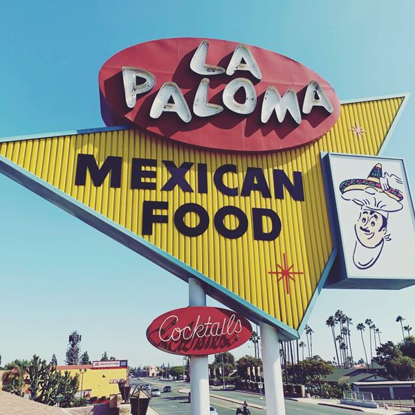
Little else remains along Route 66 from the golden days. The area along Route 66 was mostly citrus groves. On the northeast and nortwest corners with Fruit St, there were two gas stations in the 1959 and early 1960s aerial photographs. Ahead at D Street, there were some buildings on the north side of the highway.
Here you can take a short detour to visit Downtown La Verne.
Side Trip into Downtown La Verne
This is the map of the 2.6 mile round trip covering the Old Town's attractions.
"The Graduate" (1967 movie) in La Verne
Turn left along D Street and visit the location of a classic movie scene:
Drive 0.3 miles south, to your left is the location of the classic wedding scene (click to see video), the closing scene that ends the film "The Grauate" (1967). It was shot in La Verne - though in the film it is supposedly Santa Barbara.
The secene takes place in the United Methodist Church (3205 D St. La Verne.) and it is there that Ben (Dustin Hoffman) convinces Elaine (Katharine Ross) to run away from the wedding ceremony with him. Both elope into an unknown future taking a bus that still runs along D St. The image below shows both Ben and Elaine looking out of the bus' rear window at the church, and the same building nowadays.
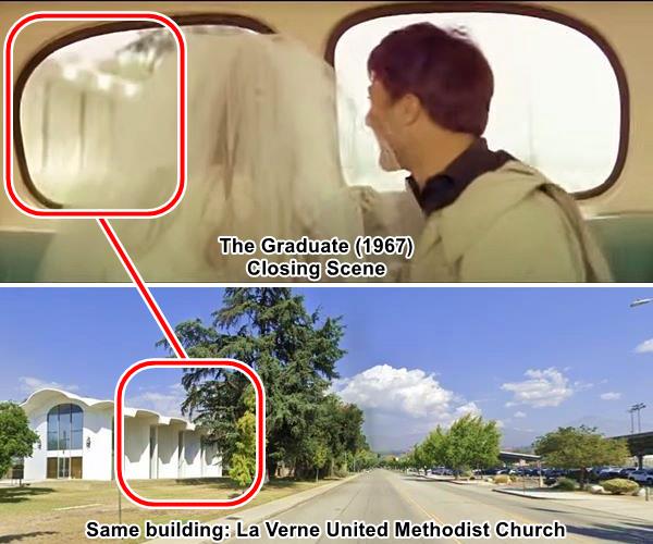
The building was designed by architects John Field Kelsey and Thornton Ladd in a very modern style in 1961. It has long narrow windows on its lateral walls and an indented roof. Both can be seen in the pictures above.
Old Town La Verne
Now head into the Old Town
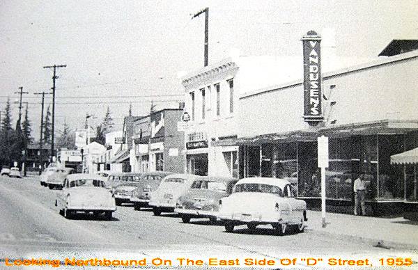
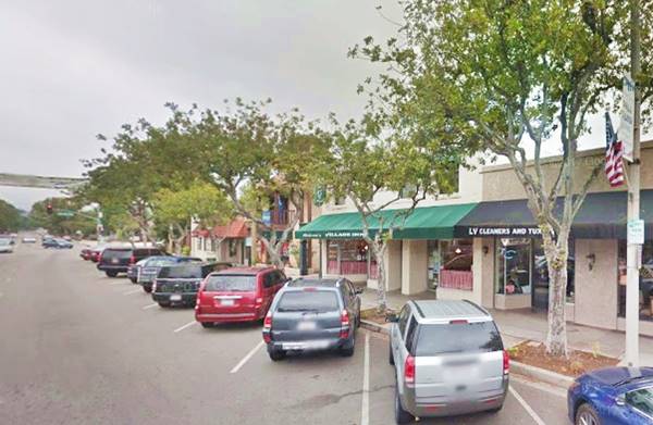
A drive down D St. into the downtown area. Third Street (where the University of La Verne is located) clearly displays what Lordsburg and later La Verne looked like. Don't miss D Street, with its quaint shops, pictured below in a "Then and Now" set of images, one is a 1955 view showing the 2300 block on D Street, East side, between 3rd St. and Bonita Ave. in downtown La Verne, the other is the same spot nowadays:
Queen Anne styled houses on E St. and Bonita Ave. (pictured) are a good sampling of the homes in the area and of course the "Brethren Church" on E Street with its Gothic Moderne style (St. view).
Before heading back to Route 66, you may want to check out the site of a building dating back to 1868.
Carrion Adobe
California Registered Landmark
Those interested in history, can go further afield and visit the site of an ancient home dating back to 1868; see this map with directions. It is located at 919 Puddingstone Drive, La Verne (Map with location).
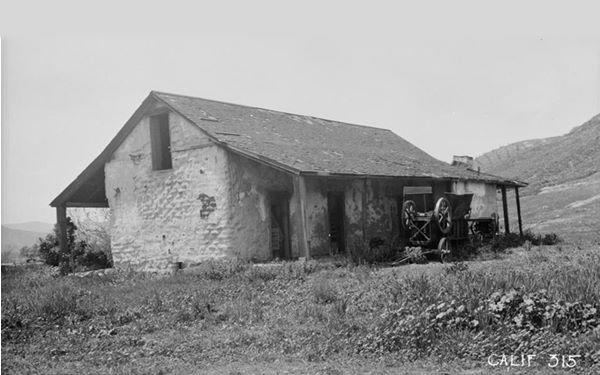
There is a plaque at the site. The house was built in 1868 by Saturnino Carrión on his ranch that covered 380 acres and was part of the Rancho San José that belonged to Saturnino's uncle, Ygnacio Palomares.
Carrión mortgaged his home to fight against the creation of the Puddingstone Reservoir on his land. He lost, as the lake next to it proves.
The place lay abandoned though it was designated as a state historic landmark in 1945; and served as a hen run until it was restored by Paul Traweek in 1951.
The home, built in sun baked bricks (adobe) has an L-shape. Now it is private property with high ceilings with the original beams, and 22-inch thick adobe walls that provide natural cooling even during the peak of summer. Below is a vintage photograph of it.
Mr. D's Diner
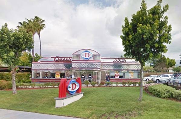
Head back to Foothill Blvd., and head west. At the freeway's underpass (CA-210), Footill now has an "S" shaped curve; its original course was straight until the freeway was built. On the north side of the underpass is retro classically designed Diner, Mr. D's, at 919 Foothill Blvd. to your right.
A shining stainless steel building with a classic look, the Diner is an eye-catcher.
Continue your Road Trip
Ahead at Baseline Rd. you leave La Verne to enter San Dimas. This spot marks the end of your tour of La Verne. Head west to continue your Route 66 Road Trip and visit the next town along the highway: San Dimas.

Sponsored Content
>> Book your Hotel in San Bernardino

Credits
Banner image: Hackberry General Store, Hackberry, Arizona by Perla Eichenblat
A Guide to the Golden State; Federal Writers' Project of the Works Progress Administration, Hastings House, New York, 1939.
Jack DeVere Rittenhouse, (1946). A Guide Book to Highway 66.


