Route 66 in Irwindale CA
Index to this page
About Irwindale California
Facts, Trivia and useful information
Elevation: 469 ft (143 m). Population 1,423 (2025).
Time zone: Pacific (MST): UTC minus 8 hours. Summer (DST) PDT (UTC-7).
Irwindale is a very small city located just south of Route 66 in Los Angeles County in southern California on the San Gabriel Mountains' foothills; it is part of the Los Angeles metropolitan area.
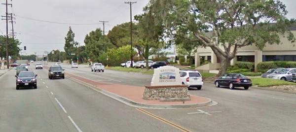
Welcome to Irwindale sign on Foothill Blv on the east side of the town
The History of the city of Glendora, California
This part of California has been inhabited for over 10,000 years, read more about the early history of this area in History of Azusa, that lies on the eastern side of Irwindale.
The first settlers were the families of Fecundo Ayon and Gregorio Fraijo during the 1850s. The railway was built through this area in 1887 when a subsidiary of the Santa Fe Railroad linked its main line in San Bernardino with Los Angeles.
The post office opened in 1899.
Irwindale, the name
The town which finally incorporated in 1957, and was chartered in 1986 was named after a local citrus grower. The name appears in the USGS maps of the area of the early 1900s. with Irwindale Ave. running with a north-south course.
This was an open area until the mid 1950s, located along the San Gabriel River, beyond the city limits of Azusa and Covina to the east and Monrovia, and El Monte to the west. In fact, there is no reference about Irwindale in any of the early maps or accouns of the region.
The USGS survey along the Santa Fe railroad of 1915 says the following: "Two miles west of Azusa the train crosses San Gabriel Wash, the bed of San Gabriel River, the largest stream flowing from the San Gabriel Mountains. The canyon through which the San Gabriel emerges from the mountains is in sight about 3 miles northeast of the trestle over the wash. During the rainy season San Gabriel River is a stream of considerable size, furnishing water for irrigating many citrus groves and other orchards and fields on the slope south of the mountains. During the dry periods it dwindles to a mere brooklet, even within the canyon."
In the early 1910s, the National Old Trails (N.O.T.) Association promoted a highway link between New York and Los Angeles. The trail used Huntington Dr. across Duarte, and as a ford across the mostly dry San Gabriel Wash, then south along Irwindale Ave to Foothill Blvd. and eastwards to San Bernardino. The 1912 map by the Automobile Club of Southern California shows Azusa (26 mi. from LA), where the road crossed the S. Fe railroad and to the west was Duarte, no signs of Irwindale.
A bridge was built in 1922 to carry the highway across the San Gabriel River, and when Route 66 was created in 1926 it used the alignment of the N.O.T. highway and the new bridge. It remained on this alignment until 1974 when its western terminus was moved eastwards to Needles CA.
The USGS maps after 1928 show Route 66 running between Azusa and the San Gabriel River and no other town until Duarte. A cluster of buildings appears two miles south along Iriwindale Ave. and figures as "Irwindale".
The small community town began to grow when the demand for road paving led to the development of the rocks in the area as a source of crushed rock and gravel as well as sand. Hence the City of Irwindale's nickname as "Jardín de Rocas" which is Spanish for "City of Rocks".
In the mid 1950s, Los Angeles suburbs started to expand and several small communities in this area incorporated to avoid being absorbed by the older and larger ones such as Monrovia, Pomona or Azusa. This led to the incorporation of Baldwin Park (1956), Durarte (1957), Bradbury (1957) and Temple City (1960), a land grab took place between these small communities.
By the 1960a, Route 66 had been replaced by the freeway as a major thorughare and traffic along Foothill Blvd. and Huntington Dr. dwindled. In 1964 the western terminus of Route 66 was formally moved from Santa Monica to Needles CA; however, only the highways up to Pasadena were decertified, the remaining ones remained signed as Route 66 until I-40 was completed between Barstow and Needles in the early 1970s.

Accommodation in Irwindale
You can find your room in the neighboring city of Monrovia.
> > Book your Hotel in Monrovia
More Lodging near Irwindale along Route 66
Below you will find a list some of the towns along Route 66 east and west of Irwindale; click on any of the links to find your hotel in these towns.
>> Check out the RV campground near Irwindale, in Pomona
The Weather in Irwindale
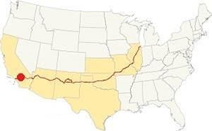
Location of Irwindale on Route 66
Irwindale has a warm Summer Mediterranean climate. Semi-arid, with hot and dry summers and cool winters. The average monthly temperatures does not surpass 71.6 °F (22°C).
The town has an average of 290 sunny days yearly. During fall (autumn) the strong hot and dry Santa Ana winds blow in from the desert and increase the risk of wildfires.
The summer average high is 90°F (32°C) and the average low is 62°F (17°C).
The winter average high in January is 68°F (20°C) and the average low is 43°F (6°C). The peaks of the San Gabriel Mountains will be covered with snow but none falls in Irwindale.
Rainfall averages 18.2 in. per year (461 mm), with the period May to September being the driest one with less than 0.3 in. monthly (8.4 mm) and mostly 0.01 in (0.3 mm).
Tornado risk
Irwindale is located very close to the Pacific Ocean and well beyond the Rocky Mountains (western limit for tornadoes) so there is no risk of tornadoes in town.
Tornado Risk: read more about Tornado Risk along Route66.
Map of Route 66 in Irwindale
>> Custom map of Route 66 through Irwindale.
National Old Trails Highway (N.O.T.) in Irwindale
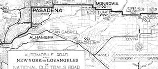
1912 N.O.T. Road map
Click on image to enlarge.
Credits
By the early 1910s automobiles were becoming popular, but the highways were in terrible conditions. Across the nation organizations were created to promote the need for better roads. This led to the creation of the National Old Trails (N.O.T.) Association. They lobbied for, and created a highway between Los Angeles and New York. It ran close to the Santa Fe railway across California and Arizona.
The 1912 map by the Automobile Club of Southern California shows the highway running westwards from Glendora, crossing the tracks there (28 mi.) and then going through Azusa (26 mi. from LA), where it crossed the S. Fe railroad again. It then ran north, turned west, and crossed the San Gabriel River into Duarte and then river followed a step-shaped alignment towards Monrovia. Click on the map above to enlarge it. As you can see, Irwindale does not appear on it.
In 1922, a bridge was built across the San Gabriel River which smoothed the link between Foothill Blvd. and Huntington Dr.
Route 66 Map
There was only one alignment of U.S. Highway 66 west of Azusa. Used from 1926 till 1974. It ran along Foothill Blvd. The map below shows the highway in the Los Angeles region in 1927. You can follow Route 66 from Victorville in the east, to San Bernardino and west to Pasadena and Los Angeles. Irwindale is not on the map.

1927 Road map, SW CA
Click on image to enlarge.
Credits

Detail 1930 roadmap
Click on image to enlarge.
Credits
The black and white 1930 thumbnail map above also shows the alignment of Route 66 from Victorville to Los Angeles.
The map below, from 1928 shows Route 66 running from Glendora, through Azusa, crossing the empty area at San Gabriel River where there are two gravel pits, and then through Duarte and into eastern Monrovia. There were no buildings in Irwindale, only the highway and the tracks of the Santa Fe and the Pacific Electric lines. This was unincorporated Los Angeles County land.

1956 Shell Roadmap, SW CA
Click on image to enlarge.
Credits
The map above shows the same area in 1956; a freeway now links Victorville with Cajon and San Bernardino with Los Angeles. Irwindale doesn't appear in it. In the 1950s, the freeway system in LA would start to divert traffic away from Route 66. In 1964, Route 66 was replaced by the freeway and traffic along the highway decreased.
Route 66 Alignment near Irwindale
With maps and full information on the Mother Road.
- Pasadena to Santa Monica (Next)
- Barstow to Pasadena (Irwindale's)
- Topock to Barstow (Previous)

Irwindale Route 66 Sights
Historic Context
The "Guide to the Golden State" written by the WPA and published in 1939, described the Irwindale section of Route 66 without mentioning the town, as follows:
...AZUSA, 27.6 m. (611 alt., 4,808 pop.), dating from the boom year of 1887, is vet another citrus-shipping center. The name is derived from Asuksag-na, name of an Indian village here.
The name of DUARTE, 31.9 m. (600 alt., 1,326 pop.), center of an old orange-growing district, commemorates Andreas Duarte.... WPA (1939)
Jack Rittenhouse in his "...Guide Book to Highway 66" (1946) wrote about this segment west of San Bernardino to Pasadena, but only mentions a list of towns: "... AZUSA, 343 mi., DUARTE, 347 mi.; MONROVIA, 350 mi., and ARCADIA, 352 mi....", so there is no refrence to Irwindale.
What to Do and see in town
The Shortest Stretch of the whole Route 66
Only 0.9 miles long
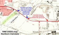
As mentioned further up, this area west of Azusa and east of Duarte was a flat alluvial plain, covered with gravel and sand and it was unincorporated Los Angeles County territory. The businesses along Route 66 concentrated in the towns eas and west of the San Gabriel River. However, in the late 1950s, the small communities in this area all rushed to incorporate to avoid being annexed by their bigger neighbors. In 1957, when it incorporated, Irwindale, with a small village center 2 miles south of Route 66 claimed the highway as its northern border. Azusa expanded westwards to the western shore of the San Gabriel River and took the north half of the bridge and viaduct, leaving the south half to Irwindale.
This became the shortest stretch within a town along the whole of Route 66.
- 0.6 mi. from Azusa city limits to the viaduct. The whole of Route 66 is part of Irwindale. We marked it with red arrows in the map (click on it to enlarge it).
- 0.3 mi. the viaduct and bridge across San Gabriel Wash and River. Only the eastbound lanes are part of Irwindale.
- 0.9 mi.Total length of this section.
The second and third places in terms of shortest legs corrspond to:.
- 2nd. place goes to Pomona CA one, with barely 1.1 miles.
- 3rd place goes to Berwyn Illinois with 1.5 miles.
Below is an aerial view of this area taken by Howard Kelly in 1955, looking northwest at Foothill Boulevard. from Azusa (to the right, not in the image) towards Duarte (upper left) and the San Gabriel Mountains. Click on it to enlarge it.
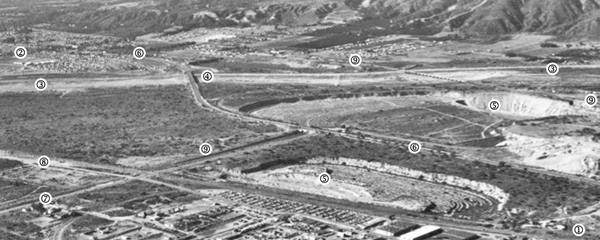
Map Key: (1) Azusa, (2) Duarte, (3) San Gabriel Wash & River, (4) Bridge across San Gabriel River, (5) Gravel pits, (7) Irwindale Ave., (8) Santa Fe Railroad, (9) Pacific Electric tracks whose old bridge washed out by the 1938 flood can be seen too.
As you can see, it was just open countryside, no orange groves grew here in the stony and sandy ground.
San Gabriel River
The river runs from the San Gabriel Mountains in the North, to Seal Beach on the Pacific Ocean in the South. It crosses over 19 cities in its 60-mile course. It has a basin that drains 689 sq. mi. of mountain area.
Looking north towards San Gabriel Canyon and Mountains along the river from the Route 66 bridge.
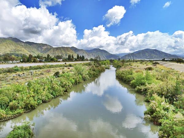
Since the early 1900s, engineers have been working to control the floods caused by heavy rains, conserve water for dry periods and protect the urban areas it crosses. Most of the river now flows along concrete encased flood channels.
In San Gabriel Canyon, before the river reaches the lowlands, the San Gabriel dam was built in 1939 followed by Morris Dam, both regulate the flow of water. into the relatively flat alluvial plain of the San Gabriel Valley.
Here water is sent to "spreading grounds" to recharge the local aquifer, an impportant water supply for the Valley's communities.
The river widens into a Wash, dry most of the time, except during the wet seasons, passes the ruins of the bridge of the Pacific Electric streetcar line, the Route 66 bridge on Huntington Dr. and flows into the flood control basin created behind the Santa Fe Dam by I-210.
Over millennia, the San Gabriel and other rivers flowing into the valley have deposited vast ammounts of sand and gravel forming a layer up to 10,000 feet (3,000 m) deep. The mountains are still rising, at about 2 inches (5 cm) per year, and their steep slopes plus strong rainfall causes rock slides and heavy erosion.
These sediments have formed the alluvial plain in San Gabriel Valley, that in Irwindale is mined in gravel quarries.
Quarries
Since the early 1900s, gravel quarries have been tapping into the rocks, sand and pebbles here in Irwindale. Over 1 billion tons of aggregate have been taken from these sites and used in construction projects across the Los Angeles County.
It is one of the largest aggregate mining areas in the U.S., with seventeen gravel pits. Currently they can only be excavated to a depth of 200 feet (61 m) to avoid cave-ins.
The San Gabriel Bridge on Route 66
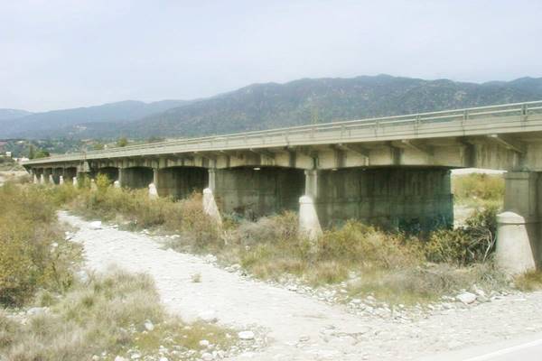
The original bridge carries the northern - westbound lanes of the highway and was built in 1922. In 1930 a second half was added to carry eastbound lanes. It was built in concrete and is 680 feet long (207 m), with a viaduct on its eastern side. It has twelve spans with concrete deck girders. See this St. view of the brige.
Continue your Road Trip
So, as you enter the viaduct heading west you leave Irwindale and re-enter Azusa, and when you exit the bridge on its western tip you enter the next town on your Route 66 road trip, Duarte.

Sponsored Content
>> Book your Hotel in San Bernardino

Credits
Banner image: Hackberry General Store, Hackberry, Arizona by Perla Eichenblat
A Guide to the Golden State; Federal Writers' Project of the Works Progress Administration, Hastings House, New York, 1939.
Jack DeVere Rittenhouse, (1946). A Guide Book to Highway 66.


