Route 66 in Duarte CA
Index to this page
About Duarte California
Facts, Trivia and useful information
Elevation: 512 ft (156 m). Population 21,837 (2025).
Time zone: Pacific (MST): UTC minus 8 hours. Summer (DST) PDT (UTC-7).
Duarte is a relatively new city (it incorporated in 1957) located former Route 66 in Los Angeles County, in southern California on the San Gabriel Mountains' foothills. It is part of the Los Angeles metropolitan area and lies on its northeastern side.
The history of Duarte
The area at the foot of the San Gabriel Mountains has been inhabited for more tha ten thousand years. When the Spanish explored the region in the 1600s, they met the local "Tongva" natives, and named them Gabrielino (Gabrieleño) after the San Gabriel Arcángel Mission which the Spaniards founded nearby in 1771.
The Mission owned a large area of land which after Mexico's independence from Spain (1821) was "secularized"; meaning it was confiscated from the Catholic church becoming fiscal land which was granted to local citizens.
In 1841, the Governor of California, Juan Alvarado granted a 6,596 acre (2.670 ha.) tract to a former solider, Andrés Duarte (1805-1863), and it became known as the Rancho Azusa de Duarte.
Duarte built a home in adobe on what is now Tocino Drive.
After Mexico lost California to the U.S. during 1846-48 war, Duarte had to file a claim for the recognition of his grant under the 1848 peace Treaty of Guadalupe Hidalgo. He sold parts of his land to pay the legal costs and back taxes. The ranch was finally awarded to him in 1878, but by then the whole ranch had been sold.
The new landlords owned 40-acre plots and grew citrus on them.
The Santa Fe railroad extended its line through Duarte in 1887 crossing the San Gabriel River just east of it. The railway linkied its main line in San Bernardino across the San Gabriel Valley and into Los Angeles.
The Name: Duarte
The city took its name from the Ranch which in turn was the surname of its owner, Andrés Duarte.
Duarte is of Portuguese origin and indicates the descendants of the "Duardos" (Edwards), meaning "the son of Edward". It was popular in the Middle Ages due to the English Saint Edward born in 1004 and the Portuguese King Don Duarte (1391-1438). First recorded in writing in 1509 in Vizcaya, Aragon, Spain, mentioning a noble descendant of King Duarte.
The 1915 survey conducted by the USGS along the Santa Fe railroad shows Duarte depot on the map, but said nothing about the town. At that time,
the use of cars was becoming popular, and the National Old Trails (N.O.T.) Association was formed to promote a decent highway link between New York and Los Angeles. In Duarte it was aligned along Huntington Drive all the way to the San Gabtriel wash, which it forded to reach Azusa. The current bridge on Route 66 was built in 1922, curving south and then east to continue along Foothill Blvd. into Azusa.
Route 66 was created in 1926 and it was aligned using the N.O.T. highway in California.
Route 66 was replaced by the freeway network in the mid 1950s and by the mid 1960s most of the traffic chose to drive along the freeways. In 1966 Duarte and Fontana teamed up to try to have a large sign posted in San Bernardino proclaiming that Route 66 remained a through route into Los Angeles. They failed.
Trivia
Alton Glenn Miller, the famous big band musician, composer, and bandleader in the swing era, built a house in Duarte where he planned to settle after World War II. Unfortunately he died in 1944 serving in France. The home burned down during a wildfire in 1980.
Medicine: City of Hope
The dry climate of the San Gabriel foothills led to the establishment of the Jewish Consumptive Relief Association in 1913. It helped treat people suffering from tuberculosis. Nevertheless, TB was a mortal disease until the discovery of antibiotics. It later became the City of Hope National Medical Center (a world-renowned cancer treatment hospital).
The Carmelite Sisters of the Most Sacred Heart of Los Angeles opened the Santa Teresita Rest Home in Duarte in 1930; and it is still open as an outpatient health care center.
Duarte: City of Hope Murals
The murals are located at 1500 E Duarte Rd., Duarte. It is a 1 mile drive to the south of Route 66 as shown in this Map with directions.
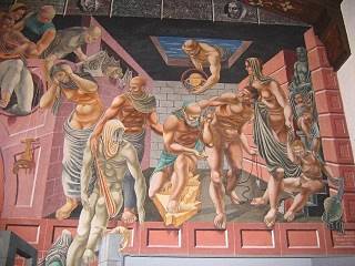
Detail of "History of Medicine". Source
The Murals painted in 1936 by Philip Guston and Reuben Kadish, and were part of the Federal Art Project and the Works Progress Administration during the Great Depression as a "New Deal" project. They were restored in 1998.
There are two, "Physical Growth of Man" and (see image) "History of Medicine", each covering 163 sq. ft. (15 m3). They are in the Visitors Center, in those days it was the Los Angeles Tubercular Sanatorium.

Accommodation in Duarte
You can find your room in nieghboring Claremont.
> > Book your Hotel in Claremont
More Lodging close to Duarte along Route 66
Below you will find a list some of the towns along U.S. Hwy 66 east and west of Duarte; click on any of the links to find your hotel in these towns.
>> Check out the RV campground near Duarte, in Pomona
The Weather in Duarte
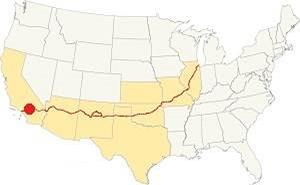
Location of Duarte on Route 66
Duarte has a warm Mediterranean climate, which is semi-arid, it has hot and dry summers with cool winters. The average monthly temperatures do not surpass 71.6 °F (22°C).
The town has an average of 290 sunny days yearly. During fall (autumn) the strong hot and dry Santa Ana winds blow in from the desert and increase the risk of wildfires.
The summer average high is 90°F (32°C) and the average low is 62°F (17°C). The winter average high (Jan) is 68°F (20°C) and the average low is 43°F (6°C). The peaks of the San Gabriel Mountains will be covered with snow but none falls here in San Gabriel Valley.
Rainfall averages 18.2 in. per year (461 mm), with the period May to September being the driest one with less than 0.3 in. monthly (8.4 mm) and mostly 0.01 in (0.3 mm).
Tornado risk
Duarte is very close to the Pacific Ocean very far from the Rocky Mountains (western limit for tornadoes) so there is no risk of tornadoes in town.
Tornado Risk: read more about Tornado Risk along Route66.
Map of Route 66 in Duarte
>> Custom map of Route 66 through Duarte.
National Old Trails Highway (N.O.T.) in Duarte
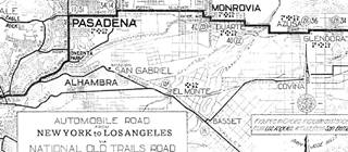
1912 N.O.T. Road map
Click on image to enlarge.
Credits
As mentioned further up, by the early 1910s automobiles were becoming popular, but the highways were in terrible conditions. Across the nation organizations were created to promote the need for better roads. This led to the creation of the National Old Trails (N.O.T.) Association. They lobbied for, and created a highway between Los Angeles and New York. It ran close to the Santa Fe railway across California and Arizona.
The 1912 map by the Automobile Club of Southern California shows the highway running westwards from Glendora, crossing the tracks there (28 mi.) and then going through Azusa (26 mi. from LA), where it crossed the S. Fe railroad again. It took a step-shaped alignment towards Monrovia after crossing the San Gabriel River and Duarte (22 mi). Click on the map above to enlarge it.
In 1922, a bridge was built across the San Gabriel River which smoothed the link between Foothill Blvd. and Huntington Dr. eliminating 2 sharp 90° turns with an S-shaped alignment between Azusa and Duarte.
Route 66 Map
The red line into Duarte marks the 1926-74 alignment of Route 66 along Huntington Dr. The map below shows the highway in the Los Angeles region in 1927. You can follow Route 66 from Victorville in the east, to San Bernardino and west to Pasadena and Los Angeles. Duarte is not on this map.

1927 Road map, SW CA
Click on image to enlarge.
Credits

Detail 1930 roadmap
Click on image to enlarge.
Credits
The black and white 1930 thumbnail map above also shows the alignment of Route 66 from Victorville to Los Angeles notice Duarte west of Azusa.
The map below, from 1928 shows Route 66 running from Glendora, through Azusa, and then crossing the empty area at San Gabriel River and into Duarte and into eastern Monrovia. Notice that it had a sharp turn northwards along Highland Ave. and another to the west along Royal Oaks Dr (in those days Foothill Blvd.) This was bypassed in the early 1930s.
>> violet line is the 1926-1931 alignment out of Duarte.

1956 Shell Roadmap, SW CA
Click on image to enlarge.
Credits
In 1932 Huntington Dr. was paved west of Highland Ave in Duarte and realigned on the eastern side of Monrovia where it linked with the older alignment using S Shamrock Ave.
West of this point, Highland Ave was extended and paved along the southern side of Monrovia into Arcadia and Route 66 was aligned along it in 1934.
>> green line is the 1926-1934 alignment into Monrovia.
The map above shows the same area in 1956; a freeway now links Victorville with Cajon and San Bernardino with Los Angeles. Duarte doesn't appear in it. In the 1950s, the freeway system in LA would start to divert traffic away from Route 66. In the 1960s drivers opted for the freeway and traffic along Route 66 decreased. In 1964 the western terminus of Route 66 was formally moved from Santa Monica to Needles CA; however, only the highways up to Pasadena were decertified, the remaining ones remained signed as Route 66 until I-40 was completed between Barstow and Needles in the early 1970s.
Route 66 Alignment near Duarte
With maps and full information on the Mother Road.
- Pasadena to Santa Monica (Next)
- Barstow to Pasadena (Duarte's)
- Topock to Barstow (Previous)

Sights and Attractions in Duarte
Historic Context
The 1939 "Guide to the Golden State" written by the WPA described the Duarte section of Route 66 as follows:
The name of DUARTE, 31.9 m. (600 alt., 1,326 pop.), center of an old orange-growing district, commemorates Andreas Duarte, grantee of a 4,000-acre tract on the site, who constructed a ditch to bring water from San Gabriel Canyon for irrigation purposes. WPA (1939)
Jack DeVere Rittenhouse rode the whole of Route 66 in 1946 and wrote his "...Guide Book to Highway 66" in which his entry of Duarte is merely one town among many: "More towns you pass through include LA VERNE at 336 mi., GLENDORA, 241 mi.; AZUSA, 343 mi., DUARTE, 347 mi.; MONROVIA, 350 mi.,"
What to Do, Places to See
Driving west from Irwindale, you enter Duarte after crossing the San Gabriel River. The highway curves towards the west. Now it is built-up, with modern buildings and apartments lining it, in the past it was mostly open countryside.
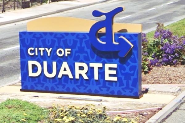
There is a sign in the median, pictured below that has Andres Duarte's brand; the brand, registered in 1843, is a stylized "d". Nowadays it forms part of the City's seal and flag, and it is also etched on a hill overlooking the town (satellite view of the hillside marker).
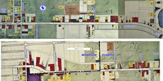
The two maps in the image show the land use in Duarte in 1940s. The green coloring marks fields, citrus groves and orchards, with chicken hatcheries. The beige color shows the natural vegetation. Yellow and orange is residential while red marks commercial buildings.
Almost all of the moteles, gas stations, cafes, juice stands have vanished. In our description, we will use the ❌ symbol to mark those that have been torn down.
Into Duarte
One thousand feet west of the bridge the highway curves and turns west. Here, at the curve, just west of Las Lomas Rd. there was an orange stand and a service station (2695 E Huntington Dr). By 1964 there was another gas station on the NE corner.
Casa Bonita Motel ❌
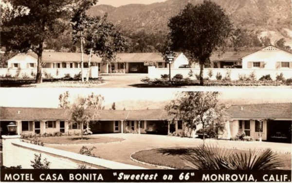
To your right, its postcard from the 1940s tells us it was Nestled in the foothills of Sierra Madre mountains. Located between Azusa and Monrovia " at 2541 E Foothill Blvd (in those days it hadn't been yet renamed Huntington Dr. in this section). It was owned by Russell Gougeon and managed by Mr. and Mrs. B. J. Norris. Pictured below. Torn down in the late 1960s.p>
The Trails ❌
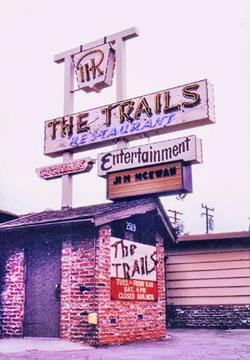
The Trails Restaurant. Source
Next to it, at 2519 East Huntington Drive was the Trails; a cocktail bar and Western styled steak restaurant. It opened in 1952 and remained open until 2001. Bill and Edith Brothers (1936-2021) owned it. It was razed the following yar and a condominum that now stands on the site, a marker with a plaque telling its story is at Huntington and Waterfall Pl (St. view). The inner streets are named after the restaurant's dining rooms: Hidaway Ln, Crossroads Ct., Waterfall, and of course Trails Ln. after the restaurant.
Ahead at 2445 Huntington there was a Cafe and next to it at what is now Capri Ct., a motel.
Hi-Way 66 Foothill Motel ⁄ Capri Motel ❌
In the 1940s this was 2435 E Foothill Blvd. now it is the same number on Huntington Dr. The postcard below tells us: "25 Hotel-type concrete cottages with closed garages; 6 with kitchens All new elegantly furnished, fully carpeted. Tiled showers, Panelray, vented heat. At foot of mountains; 875 ft. altitude. In orange grove section of California. Healthful, Restful, Clean, Quiet. 5 mi. Santa Anita race track 21 mi. downtown Los Angeles Hollywood. Owned by Dr. and Mrs. F. R. Braune. Managed by A. W. Seeds."
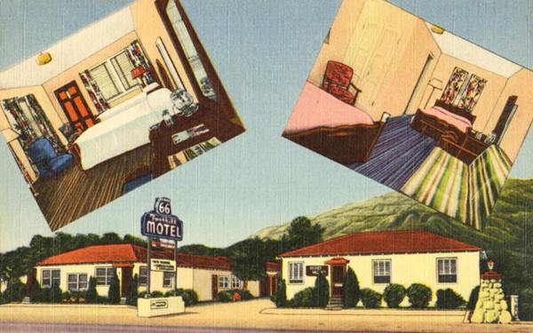
At some time during the 1950s it was renamed the Capri Motel and its neon sign was modernized. It was torn down in the 2006.
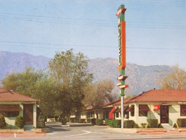
Monte Vista Motel ❌
Located at 2419 at E Huntington Dr was the Monte Vista Motel. This Auto Court with 11 units appears in the early 1940s map; next to the cafe that later would become the Hi Way 66 Foothill Motel. Also on the north (right) side of the highway. The name was later changed to Monte Vista Motel (the words are Spanish, and can be translated as "where you can see the mountain"). In the late 1960s or early 1970s it was torn down.
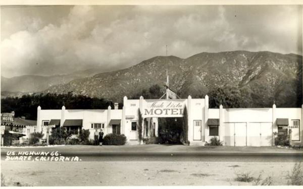
Adjacent to the Monte Vista there were two motels, with 4 units each, at Patel Pl, and Ohio Way respectively, the latter was located at 2415 Huntington, the Ohio Motel. Followed by a Service Station at Columbia Trail.
3 Peppers Cafe ❌
At the next corner, to your right, where Mt. Olive Dr. now meets Route 66, there was a Cafe (2301 Huntington Dr) and just west of the SW corner another Cafe at 2260 Huntington, the "Famous Three Peppers Cafe" established in 1926 it originally served "Special Steak Dinnres, East Side Beer, The Kooler Keg, Lombard Wine. Hamburgers A Speciality", later it was ran by Herb and Eve Berry, a Cafe that also offered Coktails.
Ahead, to the right was a Service Station (2127 Huntington).
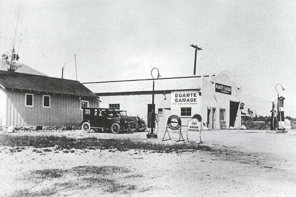
Duarte Garage ❌
The next modern crossroads is at Bradbourne Ave., here on at 2099 Huntington was Duarte Garage, with gas pumps and repair shop. On the NE corner, opposite the garage was the old Lerner gas station. You can see it in the map, on the NW corner as "auto repair."
Marigold Garden ❌
The garage was followed by a Service Station and the Marigold Garden Cafe at 2039 Huntington. It offered "Dancing Every Saturday Night... Dining, Dancing, Cocktails Two Miles East of Monrovia."
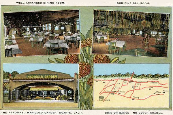
Just west of it was a Fudge Shop and across the street opposite the Marigold, there was a Service Station (2040 Huntington) in the 1930s. gone in the late 1940s. There were citrus groves till Santo Domingo Ave. and on the 1800s block of E Huntington there were several businesses.
The map only shows one motel on the north side of the highway, with 7 units, the Grand View Motel at 1859 E Huntington, owned by Jo. & Mac. Stimson "Single, Double & Kitchen Bungalows." In the 1950s, a second motel was built beside it, the Code of the West Motel.
Code of The West Motel ❌
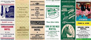
At 1835 E Huntington, owned and operated by Mr. and Mrs. Lawrence Logel. See its 1950s matchcover. Its postcard below, tells us that it was "One of the Southern Calif. Newest Deluxe Motor-Courts... Kitchenettes - air cooled - Television. All completely funished 'Home-Like Atmosphere'."
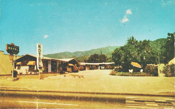
Richfield Station - Oakleigh Auto Court ⁄ Royal Oak Motel ❌
On the southeastern corner of Highland and Huntington at 1826 E Huntington, to your left. Here is the site of the now gone service station and auto court.
The image below from 1930 shows the gas station and auto court that was located at Highland and Huntington. Oakleigh is an Old English term meaning "clearing among the oaks." an appropriate name for the place.
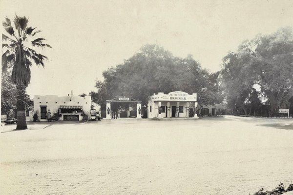
The Ancient Oak
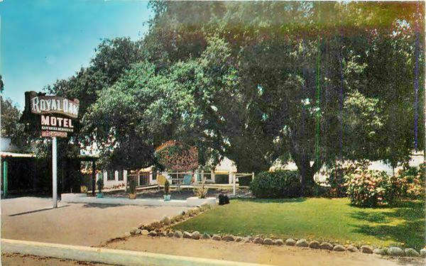
Over the years, it was renamed Oakleigh Motel and eventually became the Royal Oak Motel, whose postcard further down mentions the ancient oak tree, said to be over 100 years old, that was located behind the service station. It managed to survive until 2014 when it fell in the middle of the night. Below is a "Then" view of it, and one shortly before it fell on October 8, 2014,
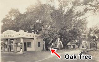
Oakleigh station and oak tree c.1940, Duarte. Source
Click on image to enlarge.
The postcard said the following: "'Tis said the old oak has stood in majestic serenity about a thousand years. Sheltering those who rest beneath its great branches spreading 140 feet and it towers 80 feet towards the sky. It was once the Council Tree - folk met for fellowship and council - court was held here and men judged friend and foe - romace was ever present and wishes came true. Come make a wish under the Royal Oak.
See its 1950s matchcover too.
Central Duarte at Huntington and Highland Ave
As the 1940s map shows, street names have changed in Duarte: What now is Royal Oak Dr. was Foothill Blvd which turned south along what now is Highland Ave. and then east along what now is Huntington Dr. South of modern Huntington Dr., Highland Ave had the same name it has now, but west of Highland what now is Huntington Dr. was called Fallen Leaf Ave.
There was a Service Station on the SW corner of the intersection followed by a Trailer Park.
Chapel Inn ❌
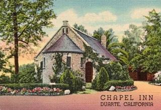
1930s Chapel Inn, Route 66 Duarte. Source
Half a block north of Huntington, at 1123 Highland Ave was the All Saints Episcopal Church. It was built in stone in 1896 on the south side of Duarte's SP railroad depot. In 1926 Delia and Clarence Gordon purchased the property, which was deconsecrated and opened a restaurant that offered "Luncheons. Teas. Dinners. Weddings". At that time Route 66 ran past it, along Highland Ave. Urban myth says that Hollywood stars Jean Harlow, Claudette Colbert, Mary Pickford and Bette Davis dined here. The Gordons moved to Oregon and sold the place to Annie Parsons of Pasadena. However after WW II she sold it to Duarte Post of the American Legion who later sold it. The building has been was torn down, but the original altar of the All Saints Church is on display in the Chapel Room at the Duarte Museum.
The 1940s map shows two motels on the south side of Huntington Dr. on the 1700s block, but we haven't been able to find their names.
Ahead on the 1600s block there were two motels, on the south side of Huntington Dr.
Evergreen Motel ❌
The Evergreen with 13 rooms appears in the 1957 Leahy guide at 1648 E Huntingdon Dr.
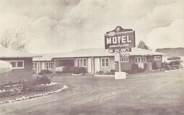
Ambassador Motel ❌
Located at 1616 E Huntington, its matchcover from the 1950s states "Accommodations for TOURISTS and PERMANENT GUESTS - Convenient - Comfortable - Reasonable Rates" and its postcard tells us it had "12 Deluxe Motel Units, 2 Apts. AAA approved... quiete and restful...Mr. & Mrs. W. A. Charlton Managing Owners"
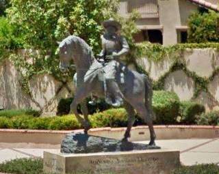
On the 1500s block, on the north side of the road there is a modern statue, and the 1930s map shows a Auto Court 12 unit with an Indian Village Liquor Store" followed by a Grocery, Cafe, Fruit Juice & Beer stores. Later in the 1940s these were replaced by a Motel 12 u (Broadmoor), Motel 4 u and a Cafe marked "Zan" (for Zanzibar), below are more details on these spots.
Bronze statue of Duarte
At 1551 E. Huntington Dr. In front of the City Hall
The equestrian bronze statue shows Andres Duarte riding his horse. It is located in Plaza Duarte, on the north side of Route 66. It was dedicated in 2007.
Broadmoor Motel ❌
At 1533 E Huntington, this motel's matchcover stressed that there was only a "Five minute drive to Santa Anita Golf Course and Santa Anita Race Track." It appeared in the 1949 Leahy's Hotel Guide and Travel Atlas as having 12 rooms. It was torn down and replaced by the modern around 1990.
Yearling Motel later El Rancho Motel ❌
Beside the Days Inn, at 1515 E. Huntington Dr. Torn down in 2022, the old "Yearling Motel dated back to the 1930s when it was the "Motel Porter".
The original name refers to a young one-year-old horse; the Santa Anita racecourse is very close to Duarte and horses were part of the local marketing theme. It was a "cottage" style motel, with independent cabins.
Its postcard states "Conveniently located in the foothills of the Sierra Madra (sic) Mountains on Highway 66. Ten minutes drive to the Santa Anita Race Track, and the Pasadena Rose Bowl. Owned and operated by Abe and Mary Doornbos."
The Yearling Motel a 1950s postcard
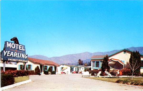
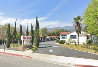
Below are two views of the old motel before it was razed.
Zanzibar Cafe
This is one of the few surviving spots on Route 66, Duarte. The The Indian Village Cafe and Zanzibar was originally further west, at 1457 Huntington Dr. It began as "The Indian Village", owned by D.L. Stevens and C.B. Ramsay who sold oranges, reed furniture, baskets and fruit packs at their "Motor Camp De Luxe THE INDIAN VILLAGE" in the 1930s . It evolved into the thatched building shown in the image below, a postcard that says it sold "Chicken Dinners, Fountain and Sandwiches," on the north side of Huntington Drive.
Indian after India, not for Native Americans. It had rattan furniture but its look was neither Indian or of Zanzibar, it was South Seas.
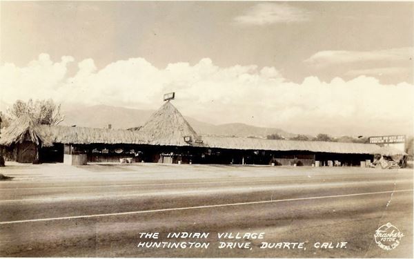
The place burned down in 1945 and was rebuilt, one block west, at 1501 E Huntington Dr. That is where D. Jay Smith reopened it in 1946 as a cocktail bar and cafe. which had a Spanish styled building. Smith had owned the Circle Cafe in Pasadena but moved to Duarte. It was still going strong in 1966 when Smith claimed that "Our steaks, seafoods and salads are great too, a prime rib is our forte."1
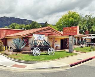
It kept going till the early 1970s and was later followed by a succession of Mexican retaurants, now it is the "Morralito," a Mexican Grill.
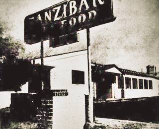
Zanzibar Cafe opening in 1945. Source
On the South side of the highway the map shows two Motels followed by a Drug Store on the 1500s block.
Zanzibar Motel ❌
A small motel with 4 units, you can see in the image below (on the left side). It was located at 1524 E Huntington.
The Filly ❌
It had 12 units and was located at 1522 E Huntington, this motel's 1950s matchcover mentions the following: "Cocktail Lounge, Dining Room, Modern Motel." A filly is a young female horse less than five years old, one that is too young to be called a mare. It was on the south side of the highway and you can see it in the following image, on the right side, with the adjacent Motel Zanzibar.
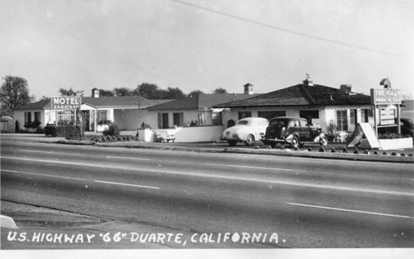
Then futher west there were another two Motels with a Cafe between them:
Hi-Way Motel ❌
At 1504 E Huntington, opposite the Zanzibar Cafe, it was a "10-unit Bungalow apartment hotel motel."
There was another motel here but we haven't been able to find out its name.
On the 1400s block, there was a 10 unit motel where the bank now stands at 1475 Huntington, followed by the Duarte Trailer Park located at 1437 Huntington Dr. and then came the twenty-room Anita Motel at 1423 E. Huntington Dr. followed by two cafes.
Sportsman Tavern ❌
Opposite, on the south side of the road, at 1452 Huntington was the Sportsman, whose postcard stated: "Located 4 miles East of Santa Anita Race Track Rt. 66 "JUST A LITTLE DIFFERENT" Reservations Required on Wild Game Dinners, Closed Mondays." Pictured below.
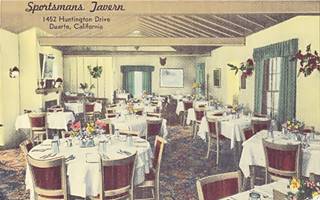
Sportsman Tavern postcard Duarte. Source
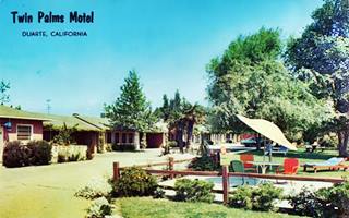
The Palms Motel, Duarte. Source
The Twin Palms ❌
At 1323 E. Huntington Dr close to its NW corner with Bella Vista Ave. Razed in the late 1960s. Pictured above.
West of Buena Vista St. to your right there was a Super Serv. Sta[tion] on the NW corner with Huntington Dr. followed by a Cafe a Motel 4 u[nits] and a motorcycle repair shop; all gone. On the south side was the
El Sorrento Motel ❌
1212 Huntington Dr., the 1957 Leahy Guide mentions the 19-room motel at this address. Now a Pollo Loco faces the street and the Huntington Hotel is at the back of the property.
The western tip of Duarte
BLVD Cafe ❌
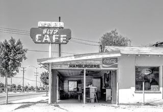
Blvd Cafe, Duarte. Source
Opened in 1946, closed in 1989. It was owned by Susie and Tommy Halburian. It began as an orange juice and burger stand and grew into a small café Its sign read BLVD as it couldn't fit the whole word "Boulevard" into it. It was eventually seized by the city and redeveloped. It was located to your right, just west of Buena Vista, on the left side of the modern Wells Fargo Bank on the 1100s block of Huntington.
At 1157 Huntington Drive you reach the western tip of the town. The north side of the street west of this point is part of Monrovia. The south side of the street is still Duarte for another 1,500 ft. till you reach Mountain Ave. There is the city limits.
Continue your Road Trip
This marks the end of your trip across Duarte; continue your Route 66 road trip in Monrovia.

Sponsored Content
>> Book your Hotel in San Bernardino

Credits
Banner image: Hackberry General Store, Hackberry, Arizona by Perla Eichenblat
A Guide to the Golden State; Federal Writers' Project of the Works Progress Administration, Hastings House, New York, 1939.
Jack DeVere Rittenhouse, (1946). A Guide Book to Highway 66.


