Route 66 in Azusa CA
Index to this page
About Azusa California
Facts, Trivia and useful information
Elevation: 610 ft (186 m). Population 48,928 (2025).
Time zone: Pacific (MST): UTC minus 8 hours. Summer (DST) PDT (UTC-7).
"The Canyon City"
Set beside the San Gabriel River at the mouth of the river's canyon, it is known by its nickname, "The Canyon City".
Azusa is a city located on the 1926 and 1933 alignment of Route 66 in eastern Los Angeles County, southern California, beside the San Gabriel Canyon.
The History of the city of Azusa, California
This part of California has been inhabited for over 10,000 years. The Spanish explored the area in the 1600s and met the "Tongva" natives, which they called Gabrielino or Gabrieleño (after the San Gabriel Arcángel Mission that they established nearby in 1771).
The Mission owned a vast area of land, and after Mexico became independent from Spain in 1821, it was "secularized" and its land's confiscated and granted to local Mexicans.
In 1841, the Governor Manuel Jimeno granted a 4,431-acre tract to Luis Arenas, known as "Rancho El Susa" (the word is an interesting deformation of "Azusa"). Arenas, in turn, sold it in 1844 to an English merchant, Henry Dalton (1803–1884), who lived in Los Angeles and had married into the Mexican community.
Dalton renamed the ranch: "Rancho Azusa de Dalton" (Dalton's Azusa Ranch) and built his home there (on what is now Cerritos Ave. and 6th St. in Azusa). He purchased more land and owned a large expanse between San Dimas and Pasadena.
After Mexico lost California to the US during the 1846-48 war, it became a state in 1850, and although the 1848 Treaty of Guadalupe Hidalgo stated that the land grants would be honored. Dalton's claim was disputed as he was not a native Mexican. Although he fought it in court and eventually won (1876), the legal battle cost him a fortune, and J. S. Salson, who loaned money to him to cover legal costs, ended up owning the land in 1885 after Dalton's death.
In the meantime, gold had been discovered in San Gabriel Canyon (1854) and the boom town of El Doradoville sprung up only to be razed by the 1861-2 floods.
Salson organized the Azusa Land and Water Company and developed the townsite of Azusa in 1887, just as the Santa Fe railroad was being built through it by The Atlantic & Pacific Railroad - a subsidiary of the Santa Fe Railroad. This railroad was the final section of the main line that crossed the U.S from the Mississippi River to a new line built between San Bernardino across the San Gabriel Valley and into Los Angeles.
The Name: Azusa
Catholic Father Crespi, who wrote the journal of the Portola Expedition of 1769, from San Diego through Los Angeles all the way to San Francisco and back, recorded the name "Azuka-nga" near the San Gabriel River. It is said to be the name of a Tongva village: ashúkshanga, of unknown meaning.
Another version says it was the name of a hill east of the city, azuncsavit or "skunk hill". However, the land grant records it in another Spanish version: "El Susa". Spanish has the word "Suso" masculine not femenine, meaning "above."
Finally, Azusa (pronounced uh-ZOO-suh) means, according to an urban myth, "everything from A to Z in the U.S.A."
Azusa was incorporated as a city in 1898. And the 1915 survey conducted by the USGS along the Santa Fe railroad said the following about it: "Near Azusa, the railway is within a mile of the foot of the steep southern front of the San Gabriel Mountains, which has been followed all the way west from the mouth of Cajon Canyon and continues to Los Angeles. Two miles west of Azusa, the train crosses San Gabriel Wash, the bed of San Gabriel River, the largest stream flowing from the San Gabriel Mountains..."
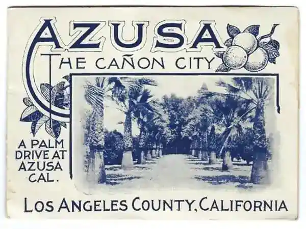
By 1915, use of the automobile had already grown considerably, and the National Old Trails Association (N.O.T.)highway linking Los Angeles and New York passed through Azusa along Foothill Blvd. In 1926, Route 66 was aligned along the N.O.T. The 1935 Road map of Los Angeles shows Route 66 through Azusa along "Center St", which in the 1939 map had become Foothill Blvd. State Highway 39 runs north of town, along the San Gabriel Canyon, past the dam, to Crystal Lake.
Azusa Ave. (CA-39) ran south and met US 60, US 70 and US 99 in West Covina.
By 1964, Route 66 had been replaced by the freeway, and traffic along Foothill Blvd. dwindled. Route 66 remained certified here until the mid-1970s, when its western terminus moved to Needles, bypassing all of California's towns west of that point.
Azusa in popular culture
The odd-sounding name coupled it with Cucamonga in a joke popularized by the Jack Benny TV Show in the 1950s. The gag was taken up by Warner Bros. cartoons with Daffy Duck (See the video) announcing a "Train leaving on track five for Anaheim, Azusa and Cuc... amonga!" of course no such train ever existed. The voice behind both "Azusa's" was that of Mel Blanc.

Accommodation in Azusa
You can find your room in Azusa.
> > Book your Hotel nearby in Monrovia
More Lodging near Azusa along Route 66
Below you will find a list some of the towns along Route 66 east and west of Azusa; click on any of the links to find your hotel in these towns.
>> Check out the RV campground near Azusa, in Pomona
The Weather in Azusa
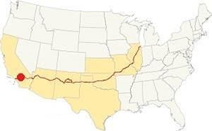
Location of Azusa on Route 66
Azusa has a warm-summer Mediterranean climate that is semi-arid. It has warm but not too hot summers with cool winters. The average monthly temperatures is less than 71.6°F (22°C)
Azusa has an average of 289 sunny days yearly. During fall (autumn), the strong, hot, and dry Santa Ana wind blows from the desert, through Cajon Pass, increasing the risk of wildfires in the San Gabriel Mountain foothill communities.
The summer average high is 90°F (32°C) and the average low is 62°F (17°C). During winter, the average high is (Jan) 68°F (20°C) and the average low is 43°F (6°C). The peaks of the San Gabriel Mountains receive plenty of snow, but none falls on Route 66 in Azusa.
Azusa's rainfall averages 18.2 in. yearly (461 mm), and the months from May to September are the driest, with less than 0.3 in. (8.4 mm) per month.
Tornado risk
Azusa is barely 40 miles from the Pacific Ocean and therefore far away from the Rocky Mountains (western limit for tornadoes) so there is no risk of them in town.
Tornado Risk: read more about Tornado Risk along Route66.
Map of Route 66 in Azusa
>> Custom map of Route 66 through Azusa.
National Old Trails Highway (N.O.T.) in Azusa
By the early 1910s, automobiles were becoming popular, but the roads were in terrible conditions, mostly dirt trails with ruts that turned into muddy traps when it rained. This led to the creation of the National Old Trails Association (N.O.T.)to promote a highway linking Los Angeles and New York. The trail was built close to the Santa Fe railway across California and Arizona. The 1912 map by the Automobile Club of Southern California shows the highway running westwards from Glendora, crossing the tracks there (28 mi.) and then going through Azusa (26 mi. from LA), where it crossed the S. Fe railroad again.
Route 66
There were two alignments of U.S. Highway 66 across Glendora, and both met in Azusa. The first one is the 1926-33 roadway that follows the alignment of the N.O.T. The following map was published in 1927, one year after Route 66 was born. It shows the highway from Victorville in the east, through San Bernardino, and then westwards into Los Angeles; you can see Azusa in it.
>> pale blue line is the 1926-33 alignment of US 66 in western Glendora into Azusa.

1927 Road map, SW CA
Click on image to enlarge.
Credits

1956 Shell Roadmap, SW CA
Click on image to enlarge.
Credits
Driving east to west, coming from San Dimas, the original Route 66 along E Foothill Blvd. took a sharp right curve heading north along Amelia Ave. and then, another sharp turn left along E. Foothill Blvd. The road then headed west, went through the center of Glendora, and then took a left on N Citrus Avenue - which marks the boundary with the city of Azusa - known in those days as Dalton. where it headed west once again along Foothill until meeting Alosta Ave. (coming from the southeast, which later became the newer alignment of Route 66).
New alignment from 1933 to 1964
>> red line is the 1933-64 alignment across Azusa

Detail 1930 roadmap
Click on image to enlarge.
Full map
The USGS map from 1928 (click on it to enlarge it) shows the first alignment along E Foothill into Azusa from Glendora. Alosta Ave., which carried the 1933 realignment, wasn't paved at this time and didn't cross the Little Dalton Wash. The highway runs straight across Azusa, which is only 10 blocks long. The rest was orange groves and fields. Then it curved to the NW to cross the wide wash of the San Gabriel River. It then took an east-west course passing north of Duarte and taking an alignment along Highland Ave (violet line in our custom map).
The black and white 1930 thumbnail map shows the alignment of Route 66 from Victorville to Los Angeles, and it shows Azusa.
The final map, further up, shows the same area in 1956; a freeway now links Victorville with Cajon and San Bernardino with Los Angeles.
In the 1950s, the freeway system in LA would start to divert traffic away from Route 66. In 1964, the freeway replaced Route 66, and traffic along Foothill Blvd. dwindled.
Route 66 Alignment near Azusa
With maps and full information on the Mother Road.
- Pasadena to Santa Monica (Next)
- Barstow to Pasadena (Azusa's)
- Topock to Barstow (Previous)
Azusa US 66 Sights
What to Do and see in town
Historic Context
The "Guide to the Golden State" written by the WPA and published in 1939, described Azisa as follows:
AZUSA, 27.6 m. (611 alt., 4,808 pop.), dating from the boom year of 1887, is yet another citrus-shipping center. The name is derived from Asuksag-na, the name of an Indian village here. WPA (1939)
A few years later, after World War II, Jack DeVere Rittenhouse rode the whole of Route 66 and wrote his "...Guide Book to Highway 66" (1946) and he mentions the towns in the San Gabriel Valley, which "... are so close together as to be practically indistinguishable from each other... More towns you pass through include LA VERNE at 336 mi., GLENDORA, 241 mi.; AZUSA, 343 mi., DUARTE, 347 mi..."
Road Trip Leg sights in Azusa
Begin your tour at the eastern end of town, driving westwards from neighboring Glendora.
Retro Neon Sign (Cane's)
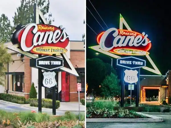
As you enter Azusa, to your right at 855 E Alosta Ave, the fast food chain Raising Cane's Chicken Fingers has paid homage to Route 66's history by adapting their oval red sign and giving it the retro look of a real 1950s neon sign, with a Route 66 shield and an arrow. Well done! Pictured below
Ahead, the highway curves to the west, and the two Route 66 alignments coming from Glendora meet: the 1926-33 US66 on E Foohtill and the 1933-64 US 66 on Alosta Ave. To your right is a classic attraction, Azusa's drive-in theater, or better said, what is left of it, its neon sign and marquee.
Foothill Drive-In Theater
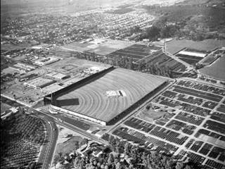
Azusa Foothill Drive-In, Azusa, looking northwest, 1963. Source
Click image to enlarge
State Landmark and classic Route 66 Neon Sign
At 675 E. Foothill Blvd. Azusa. The old "Azusa Drive-In Theater" opened in 1961 and remained open for 40 years, showing its last film on Dec. 28, 2001.
It could fit 1,510 cars, and when it closed, it was the last remaining drive-in on Route 66 west of Oklahoma.
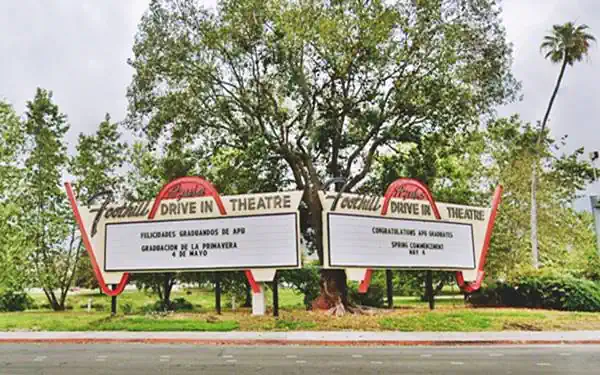
It was declared a California Landmark in 2002, and the screen was removed in 2005 by Azusa Pacific University (which owns the property), to make space for a parking lot. All that remains are the signs, with neon tubes that face Route 66 and can be seen from those driving in either direction (east or westbound). The sign can be seen in the black and white 1963 aerial photograph (click on it to enlarge it), as a narrow V-shaped sign" on the lower left side of the property where Foothill and Alosta meet. Below is a current view of this classic neon sign.
Stardust Motel
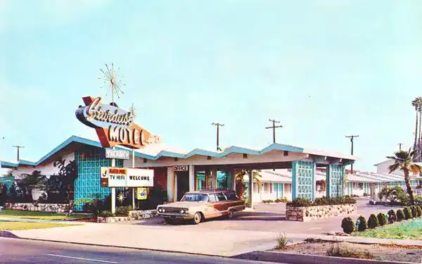
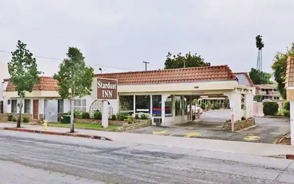
To your left at 666 E Foothill Blvd., on the south side of the road, is a classic Route 66 motel, the Stardust Motel. It had a "Large Heated Pool, Conference Room, Free Coffee, Deluxe Accommodations." Below is a "Then and Now" view of it; the decorative concrete screen blocks on the west side of the canopy are still there, and also on the front office, facing Route 66. Unfortunately, the 1960s Atomic and Space age designed roof has been covered with a more mundane Spanish tiled roofing. And the very-1960s neon sign has gone, and a duller one has replaced it.
The Stardust Motel in a 1960s postcard
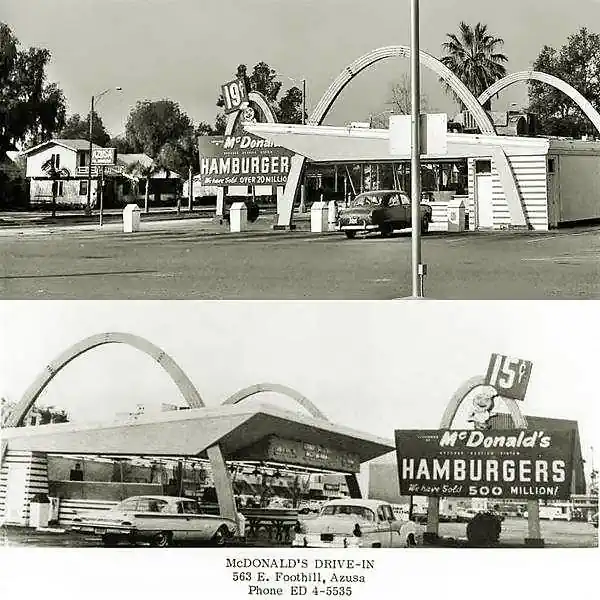
Ahead across the street, to your right on the NW corner with Cerritos Ave, there was a classic McDonald's from 1953 to the late 1990s. Now it is a parking lot. Pictured below.
The Colonial Inn (closed)
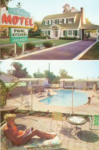
Colonial Motel in a 1950s postcard, Azusa. Source
Click image to enlarge
To your left at 534 E Foothill Blvd. Now a private home
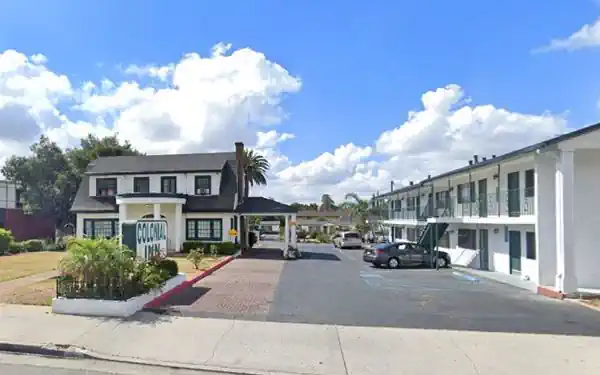
The motel had been open since the 1950s until the COVID-19 pandemic shut it down for good. The separate units in the back of the property, and a two-story building on the right side of the old gable-roofed house have been torn down.
Its postcard below promoted it as follows: "Azusa's Finest Accommodations... TV and Kitchens available. Some units air-conditioned. 14 QUIET Single and Family units, near Restaurants, Stores, Transportation, Churches. Large Pool. Your Hosts, Mr. & Mrs. Kratz."
See this current St. view. The image below is from 2019, while it was still a hotel.
In 2019 before it closed due to the pandemic.
At 444 E Foothill, the 1949 phone directory mentions the long-gone Azusa Motor Hotel. Ahead, where the Arco gas station on the SE corner with N Dalton is located, the 1949 telephone directory tells us that it was Hritz Union Service Station (304 E Foothill) at that time.
Azusa Civic Center
Listed in the National Register of Historic Places
Across the street, between N Dalton and N Alameda Aves., at 213 Foothill Blvd. The public library was located here in 1904, and in 1928, the City Hall and municipal Auditorium were completed. In 1945, the Fire Dept. headquarters was completed. It has stood here facing Route 66 since then. Check the "Then and Now" views below.
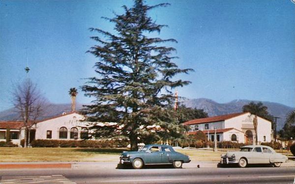
Azusa Civic Center 1950s. Source. Click picture to enlarge
In 1949, at 204 E Foothill (SE corner with Alameda) was the Reed & Rout Automotive Service and on the NW corner was the Azusa Texaco ran by Bobby Jackson at 151 E Foothill. Both gone.
The image below looks eastwards along Route 66 in 1965 (Same view now).
Looking east from San Gabriel Ave.
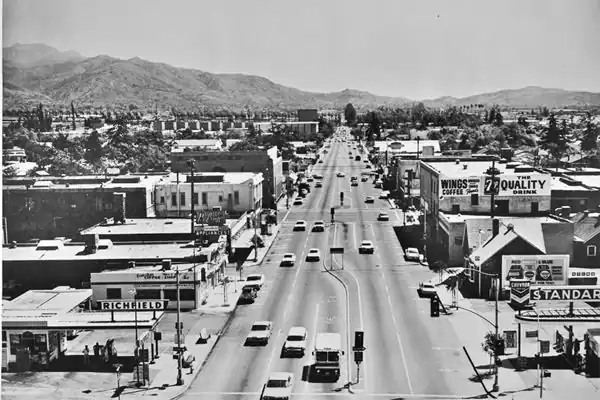
Downtown Azusa
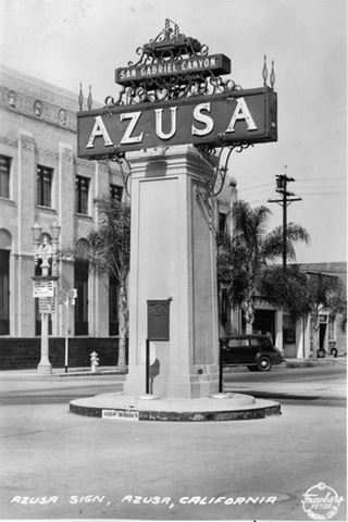
1939 Azusa sign, Azusa. Source
Click on image to enlarge
On the next corner, Azusa Ave., carrying CA-39 crossed Route 66. This was a busy commercial area, with many stores along both streets. The only surviving building is the bank on the NE corner.
Azusa Monument-Sign (gone)
There was a massive column supporting a large sign that read: "AZUZA - San Gabriel Canyon," with an arrow pointing northwards. It was located on a small roundabout in the middle of Foothill and Azusa Ave. It seems to have been removed by the mid-1940s.
First National Bank building
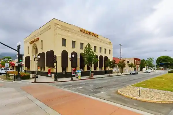
Here, on the northeast corner, is the magnificent historic Art Deco style building of the former First National Bank of Azusa. It was chartered in 1906 and operated until 1935, issuing National Bank currency banknotes until these were retired by the Federal government. In 1968 the Wells Fargo Bank acquired it.
Looking NE at Azusa Ave and Foothill Blvd at the First National Bank.
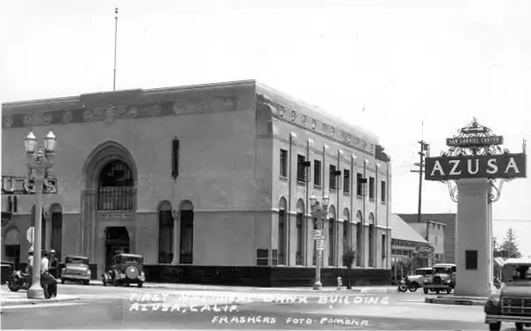
The same view nowadays, the sign has gone, but the Art Deco Wells Fargo Bank building is still the same.
Opposite the bank, on the NW corner of Azusa Ave and Foothill, there was a drug store and pharmacy where the Café is now located (pictured below, click image to enlarge).
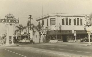
NW corner of Azusa and US66 c.1940s. Source
Click picture to enlarge
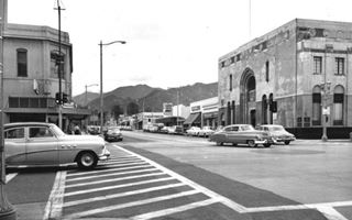
1954 looking north along Azusa Ave from US66. Source
Click picture to enlarge
The image above (click to enlarge) was taken in 1954, and looks north along Azusa Ave. at its junction with Foothill. The Bank is on the right, the drugstore on the left. You can see the circle in the concrete paving where the "Azusa" sign once stood.
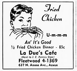
1949 phone book ad, La Due's Cafe
Here by Azusa Ave., the 1949 phone directory mentions Thelma's Cafe at 116 W Foothill, Warren's Cafe and Tavern at 112 E Foothill and just south of the crossroads, La Due's Cafe at 637 N Azusa Ave. that offered "1⁄2 Fried Chicken Dinner 85c." Sears stood on the SE corner of the intersection. All of them have been torn down.
There were two hotels here, the Azusa Hotel (639 1⁄2 N Azusa Ave), Canyon City Hotel (626 N Azusa Ave). Also gone.
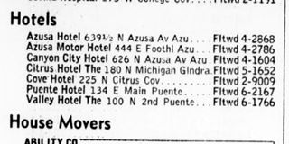
1949 phone book list of Azusa Hotels
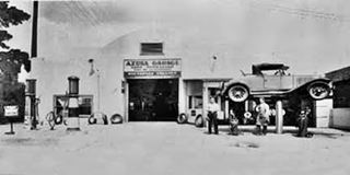
Azusa Garage, 1932. Source
Westwards along Foothill, there were four gas stations at San Gabriel, the image further up shows a Richfield at 199 W Foothill, opposite a Chevron at 198 W Foothill, and the 1949 telephone directory mentions Meeder's Associated Service Station at 200 W Foothill and Harry's Service Station with Douglas Products, at 201 W Foothill. Along the block, there was Ronnie's Shell Service Station at 248 W Foothill, and opposite, at 233 W Foothill, Tony R. Gonzalez owned the Azusa Garage. It began as a bike repair shop before 1920 and, from 1930 until the late 1960s, was an auto garage. Pictured in 1932, notice the curbside gas pumps on the left.
Ahead were the now gone Leo Harlan Tire Service; 350 W Foothill and Foothill Service; 444 W Foothill.
Liquor Store & neon sign Sign
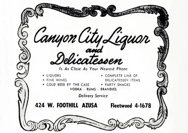
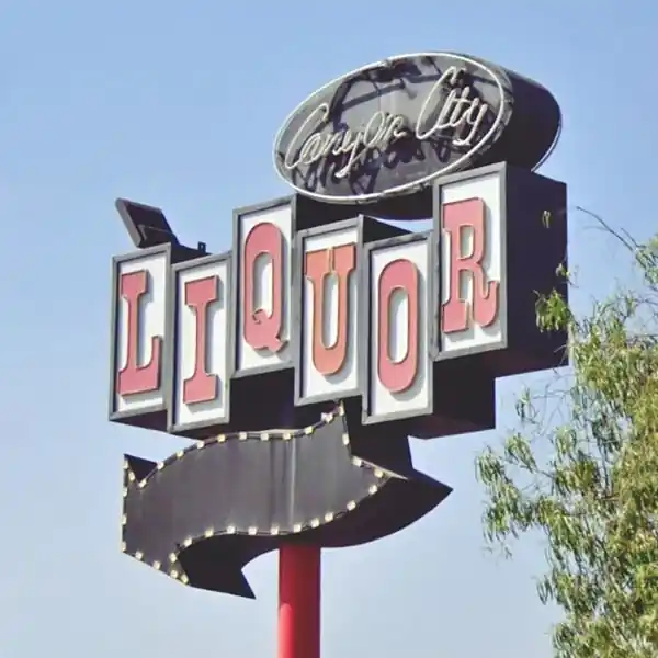
At 424 W Foothill is a surviving store with its vintage 1950s neon sign; a classic liquor store that appears listed in the 1949 phone directory as Canyon City Liquor and Delicatessen; see their ad below and the magnificent neon sign.
Canyon City Liquor Store neon sign
The highway passes beneath the former AT & SF railroad tracks and a newer bridge that was built in 2015 to carry an extension of the Los Angeles Metro line. Ahead was Jones' Service Station at 834 W Foothill, followed by Azusa Super Service at 905 W Foothill. Both have been replaced.
Corky's Place (Closed)
At 1050 W Foothill Blvd. is a small building that once housed the Bright Spot Tavern and later a classic diner, Corky's Place. It is currently closed.
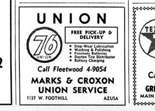
Marks & Croxon Union 76, 1949 phone book ad
Marks-Croxon Union 76
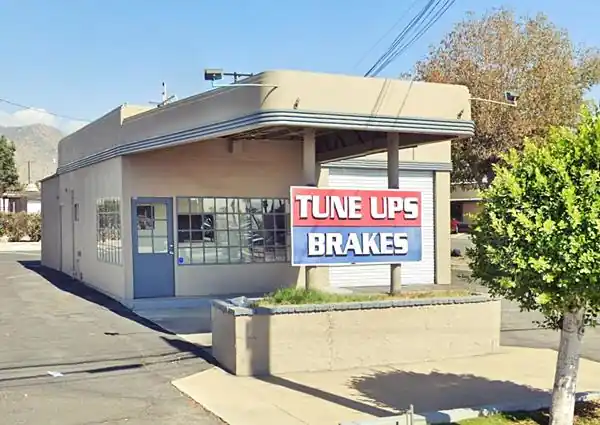
Head west and on the next block, at 1137 W Foothill Blvd., Northwest corner (N. Loren Ave.) is the remains of a vintage service station. As you can see in the image above, it appeared in the 1949 telephone directory as Marks & Croxon Union 76 and it has been restored nicely.
Now it is a brake and tune-up garage. The old streamline-moderne styled canopy with curved tips is in place, and the office with its multi-paned window too, and a single service bay to the right.
Continue your Road Trip
The Azusa leg of your Route 66 road trip ends here. Head west along Route 66 to continue your journey and visit the next town along the highway: Irwindale.
Outdoors and Nature
Bridge to Nowhere
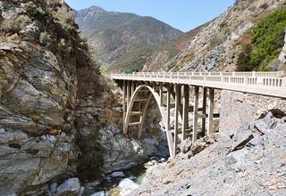
Bridge to Nowhere, Azusa. Source
An outdoor adventure: a 5-mile. uphill trek from the N.E. end of CA-39 East Fork. (6-8 hour round trip walk)
Built in the mid-1930s it was part of a road being built to link the San Gabriel Valley with Wrightwood. It branched from State Highway 39 (now the East Fork of CA-39). In 1938, two years after the bridge was finished,the Great Flood of 1938 washed the road away. This led the builders to abandon the project as maintaining the road in the mountains would be extremely costly.
The concrete bridge remains, in the middle of nowhere, as a tribute to poor state planning.
Trek from the parking area at the end of the East Fork of CA-39. Parking pass required (buy it at the Ranger Station at the entrance of the canyon).
The bridge is on private property, so stick to the trail and the bridge. Take water and keep an eye open for rattlesnakes.
This Map showing location of the Bridge to Nowhere.

Sponsored Content
>> Book your Hotel in Santa Monica

Credits
Banner image: Hackberry General Store, Hackberry, Arizona by Perla Eichenblat
A Guide to the Golden State; Federal Writers' Project of the Works Progress Administration, Hastings House, New York, 1939.
Jack DeVere Rittenhouse, (1946). A Guide Book to Highway 66.

