
Route 66 Road Trip in Oatman:
Index to this page
About Oatman, Arizona
Facts, Trivia and useful information
Elevation 2,710 ft (826 m). Population 84 (2025).
Time zone: Mountain (MST): UTC minus 7 hours. Summer (DST) no DST⁄ PDT (UTC-7).
Oatman is a small village, an unincorporated community in western Mohave County, on Route 66, northwestern Arizona. A former gold mining town in the Black Mountains.
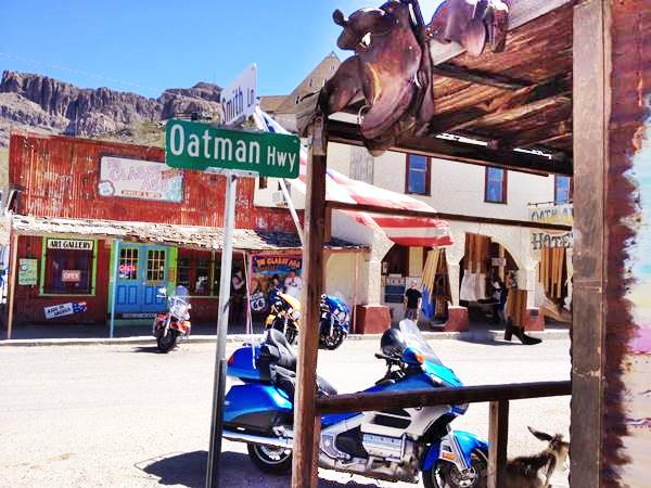
Main St. (Route 66) and the Oatman Hotel
Oatman's History

Olive Oatman, notice the ritual chin tattoo. Source
The Colorado River valley has been inhabited for the last 10,000 years. The European explorers encountered the Mojave people, a name which is a deformed version of "aha", water, and "macave", along or beside, therefore: "close to the water". They lived south of what is now Hoover Dam along the Colorado River.
Although Arizona was part of the Spanish colonies in America, only a few missionaries and silver seeking explorers (Antonio de Espejo in 1583 and Juan de Oñate in 1598) visited the area during the 1600s and 1700s. Mexico received it from Spain after its independence in 1821 but lost it to the U.S. during the 1846-1848 War.
In 1851, the U.S. Government commissioned Capt. Lorenzo Sitgreaves on an expedition to the area. The pass used by Route 66 across the Black Montains is named after him.
Lt. A. W. Whipple visited this area during his expedition in 1854 to find a route for a transcontinental railroad along the 35th parallel. He was followed by Lt. Edward "Ned" Fitzgerald Beale who also surveyed a route along the 35th parallel in 1857. His route took him to what is now Needles, CA.
This opened the way for settlers who used these trails to reach California. Among them was the Oatman family.
Johnny Moss found gold in the Black Mountains near Oatman in 1863 but chose instead to mine silver in the Cerbat Mountains. It was not until the railroad arrived in 1883 that mining took off; initially north of Kingman.
The Name: Oatman
The Oatman family, from Illinois, was attacked in Arizona by the Tolkepayas (Western Yavapai) or Apaches in 1851. Only Olive Ann Oatman (1837-1903) and her sister Mary Ann -who later died of hunger- survived.
They were sold to the Mohave Indian band of Chief Espaniol, for two horses, beans, and three blankets. He took care of them and included them in his household as domestic slaves.
16 year old Olive had her face tatooed with blue ink as was the native's custom. She was freed after five years of captivity. Olive later wrote her memoir telling her story.
The Atlantic & Pacific Railroad (later the Atchison Topeka and Santa Fe Railroad) reached the area in 1882 but went around the Black Mountains along the flat Sacramento Valley to the east and south of them.
Gold was re-discovered north of Oatman in 1901 at Goldroad and this led to the construction of better roads both west (to Kingman) and east (to Needles and Topock).
Ben Taddock strcuk gold in Oatman in 1902 and filed a claim. A tent city sprung up to cater to the prospectors who rushed in.
Taddock sold his claim which was acquired by the Vivian Mining Co. so the little town was named "Vivian".
Three million dollars of gold were mined between 1904 and 1907 and in 1909, the town changed its name to Oatman.
Just as the Vivian mine was about to close, Tom Reed discovered another vein in 1910 and the United Eastern Mining Co. struck gold again in 1915.
They were the largest gold mines in the US at that time
Population reached 10,000 during that period, now it is less than 50!.
Naturally, when the National Old Trails Highway (N.O.T.) laid its route from California to Kansas, it chose the road through Oatman. It reached the town in 1914. The The 1920s N.O.T. guide mentioned that it had "Stores, hotels, garages and camp grounds... the largest undeveloped gold mining field in the U.S."
The gold was running out and United Eastern closed operations in Oatman in 1924. But fortunately Route 66 was aligned along the N.O.T. in 1926, bringing income from motorists travelling along it.
During World War II, the U.S. Government closed the mines to use the workforce in other mines producing critical metal needed for the war effort.
By 1952 mining had dwindled so the Route 66 alignment through Sitgreaves Pass and Oatman was no longer needed. It was replaced by a new one, that was safer and straighter; it ran along level ground, through Yucca.
The town became a ghost town but recovered during the 1990s as a new wave of tourists flocked to the "old Route 66".

Hotels and Motels in Oatman
Lodging & accommodation in Oatman; sponsored content. Find a room in neighboring Needles California, just a few miles to the west:
> > Book your hotel nearby, in Needles CA
More Accommodation near Oatman on Route 66
Find more lodging & accommodation close to Oatman. There are plenty of lodging options in the cities and towns along Route 66; click on the links below to find your accommodation in these towns, listed from east to west:
Eastwards
In Arizona Along Route 66
Westwards
You are so close to Las Vegas and the Grand Canyon!


>> Check out the RV campground in neighboring Topock
The weather in Oatman

Location of Oatman on U.S. Hwy. 66, Arizona
Oatman's climate is high-desert, which is arid, dry and thanks to its altitude, cooler than the low lying terrain close to the Colorado River.
Winters and summers are cooler than those of neighboring Laughlin, NV or Needles, CA.
Snow ocassionally falls in winter with some 2 inches (5 cm) per year. Rainfall is scarce, only 7 in. of rain (178 mm).
Temperatures during the year: summer average high (Jul) 104°F (40°C) and summer low 76°F (24.4°C) Winter average high (Jan) is 56°F (13.3°C) and a winter low 33°F (-0.6°C).
Tornado risk
Oatman is located well to the west of the Rocky Montains therefore there are virtually no tornados there. Tornado Risk: read more about Tornado Risk along Route66.
Map of Route 66 in Oatman
Visit our Kingman to Topock page for a detailed description of Route 66 through Oatman. Below is the color coded interactive map:
>> Custom map of Route 66 in Oatman
This is the map of US66 from Kingman through Oatman and onwards to Topock. Route 66 followed this course from 1926 until 1952 when it was realigned via Yucca, following a safer and straighter course, without the grades and sharp mountain-road turns of the old highway.
Below are two old maps of the area close to Oatman between Topock and Kingman:

Thumbnail of the 1935 Arizona highway map. Source
Click on thumbnail map to enlarge

Thumbnail of the 1971 Arizona highway map. Source
Click on thumbnail map to enlarge
Interstate 40 advancing eastwards from California crossed the Colorado River in 1966 and replaced U.S. 66 in this area. The small settlement of Topock was bypassed as few cars left I-40 at Exit 1.
The Route 66 alignment in Oatman
Visit our pages with old maps and plenty of maps and information about US 66's alignments:
- Needles to Barstow (Next)
- Topock to Barstow (Next)
- Kingman to Topock (Oatman's)
- Williams to Kingman AZ (Previous)

Sights and Attractions in Oatman
We will tour Oatman, driving west, from Kingman, using the Back Country Byway:
The Historic Route 66 Back Country Byway
Back Country Byway

Back Country Byway sign. Austin Whittall.
This section of Route 66 between Kingman and Topock has been designated a Back Country Byway, within the BLM (Bureau of Land Management).
The road is legally accessible by any vehicle under 40 feet in length. The part of the road passing through the mountains is a very narrow two-lane with no shoulders, extremely tight switchbacks and many steep drop-offs. Wide vehicles and vehicles over 30 feet in length should use extreme caution when driving this road.
Cool Springs
We describe the segment from Kingman to Cool Springs along the The Historic Route 66 Back Country Byway in our Kingman (page #2). It mentions the Route 66 shields painted on the highway and the Cool Springs gas station pictured below:
A view of the rebuilt Cool Springs Gas Station

Shield on the roadway in front of the Cold Sprig gas station between Kingman and Oatman:

At Cool Springs the highway begins to climb the eastern flank of the Black Mountains.
Black Mountains
They are a mountain range that was formed some 15 to 20 million years ago when lava flowed thickly over a base of Precambrian granite.
They run with a north-south alignment and measure 75 miles long (121 km) and some 10 mi. wide (16 km). The highest point is Mount Perkins with 5,456 ft. (1.663 m).
Route 66 was built across the Black Mountains instead of following the route adopted by the railroad, which had easier gradients because it followed the National Old Trails highway which in turn was used to move ore out of the mines at Oatman and Goldroad.
The steep grade from east to west began at the foot of the mountains at 2,268 ft. and climbed up to Sitgreaves Pass (3,595 ft) over a distance of 9 miles. West of the pass, the road then dropped into Oatman, falling 915 ft. in a winding course along 4 miles.
Towards the Black Mountains

Watch out for Burros sign near Oatman Arizona.
Perla Eichenblat
Not much has changed since the days of Rittenhouse, who mentions a gas station on mile 8 (from Kingman) -gone- an abandoned "Fig Springs Camp" at mile 18 -gone- at the point where the Gold Hill Grade climb begins, the climb to Sitgreaves Pass, which Rittenhouse calls "Gold Hill Grade".
Gold Hill Grade
It was the steepest gradient along the whole of Route 66, with hairpin turns and an even steeper grade on the western side. Rittenhouse suggested that the westbound driver "should... keep his car in second gear going down."
As the road climbs, you will notice some steps cut in the rock, on the left side of the road, in the middle of a curve: Shaffer Fish Bowl Springs (St. view); park with care and go up the steps to the "fish bowl". A spring in the dry mountains.
Sitgreaves Pass
During Rittenhouse's time there was another gas station and ice cream parlor at Gold Hill Summit (Sitgreaves Pass) on the summit itself. Now there is ample parking space on both the eastern and western sides of the pass.
At 3,595 ft (1.096 m) it offers a great view east and west. Park and enjoy the scenery.
Sitgreaves Pass on Route 66

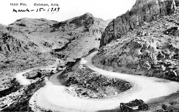
After the pass, the road descends with a constant grade and plenty of curves. Then, there are some sharp hairpin curves:
Kingman to Oatman Arizona in the Black Mountains, a hairpin bend:

1929 postcard of a hairpin bend on Route 66 in Goldenroad. Perla Eichenblat
Goldroad
A Mining Ghost Town

Route 66 byway sign at Goldroad, Arizona.
Perla Eichenblat
The road winds downwards, and two miles west of the sumit, according to Rittenhouse there was only a mechanic: "garage, no cabins, cafe or other facilities here." In those days this was a mining community with 718 residents.
As an interesting remark, he noted that there was a tow truck that would haul those whose vehicles could not make it up the road, eastbound; they charged $3.50 for the service.
Now it is abandoned, with the ruins of some buildings visible among the bushes, it is a real ghost town. Although mining is still going on in Goldroad, it is private property so please don't trespass.
Jose Jerez discovered gold there in 1900 and dug the first shaft shortly after. He sold it in 1901 for $ 50,000. The mine produced $ 2.3 million by 1907 and closed in 1916. It reopened in 1922 and closed again in 1949. In 1992 the Addwest Minerals reopened it.
After Goldroad, the road took a winding course westwards. Ahead lies the Negro Head mountain. Then it turned south towards Oatman.
The Attractions in Oatman
A Far West Mining Town
Route 66 enters the small town and becomes its Main Street. Park your car and take a stroll, it is only 0.4 miles from one tip of town to the other.
You will notice the donkeys roaming about, they are the famous "Burros":
Burros
The word "Burro" (plural: Burros) is the Spanish name for a donkey (don't mistake them for similar looking mules or asses, which are cross-species hybrids between mares and jackasses). They were used as pack animals to carry goods in tricky terrain, especially in the mountains.
Oatman has many "wild burros", and they roam about freely. You will see about 10 or 12 of them in town, wandering around.
They are protected by the Bureau of Land Management so Don't feed them, you will be fined. They look tame but don't fool around with them either.
The town's burros and those living in the mountains as wild herds, were brought to the area by the gold miners to use them as pack animals to move out the ore. When the mines closed, the burros were set free and they took to the hills.
Two burros in Oatman, on Route 66.

The Old Town
Sidewalk Egg Frying Contest!
Frying an egg on the sidewalk under the searing midday sun is one of the fun things to do in Oatman, and part of the July 4th celebrations too.

Mural at The Ore House, Oatman AZ.
A. Whittall

Gunfight in Oatman AZ.
A. Whittall

The old Glory Hole Saloon in Oatman. Perla Eichenblat
The Oatman Ghost Rider Gunfighters
As could be expected in a roudy mining town of the "Old Wild West", there were plenty of gunfights in Oatman.
And there still are! A Gunfighter organization has daily shootouts in the streets daily (1:30 and 3:30 PM). Show Times may vary due to weather or special events.
Glory Hole
Although most of the town burned to the ground during the 1921 fire, some buildings survived. Check the "Glory Hole" which despite its saucy name is a venerable site:
Main and Oatman Topock Hwy. On the southern side of town. At one time it was a Saloon, a Soda Fountain, Drugstore and Sundries shop.
And it is still standing as you can see in the photograph and in the set of "then & now" photos below. The Honolulu Club and Shell garage to the right has long gone, but its foundations can be seen under the current building. The Arizona Hotel has also been lost.
Glory Hole Then & Now
A 1951 photograph of the Soda Fountain and the now gone Honolulu Club and Arizona Hotel.
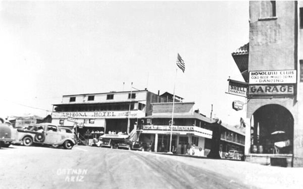
The Honolulu Club, seen on the right side of the image above, relocated to Yucca in 1952 on the new alignment.
View of the same spot today:


Elephants Tooth's Mountain. Click for St. view
Elephant's Tooth Mountain
Looking east, to the right of the old Soda Fountain, along the ridge that runs with a north to south course beyond Oatman is an unusual rock formation with a white tint, the Elephant's Tooth Mountain (3,666 ft). It is a Volcanic plug.
Head up Main Street and visit a Historic Site:
The Durlin Hotel
Listed in the National Register of Historic Places
181 Main Street. The hotel was renamed in the 1960s as the Oatman Hotel. It was originally named after John Durlin, who built it in 1902, but razed by the 1921 fire that destroyed most of Oatman's buildings.

Oatman Hotel sign. Austin Whittall.
It was rebuilt in 1922 as a two story adobe structure, with eight rooms.
Clark Gable and Carole Lombard spent their honeymoon here in 1939. Dont's miss the hotel's saloon with its walls and ceilings papered with signed one-dollar bills, a practice that began with the miners, who signed and affixed their money so they could use it when they were short of funds.
As you drive south and leave the town, to your right is the old Tom Reed Mine, discovered in 1910. Below is a "Then and Now" set of pictures of the now closed mine:
A view of Tom Reed min in a late 1920s early 1930s postcard. Notice the white colored tailings on the right.

View of the Tom Reed Mine nowadays; ruins and white tailings:

Boundary Cone
As you drive south towards Topock, 4 miles from Oatman you will meet another unusual craggy peak: Boundary Cone. The highway curves around this massive lava intrusion.
Lava Plug
Like Elephant's Tooth, it is a "Volcanic plug" also known as a volcanic neck. It was formed when the lava flowing in a vent or chimney of a volcano solidifies. The hard basaltic plug remains in place while the softer volcanic ashes that form the cone ae weathered away by erosion. All that remains is a tall prominent basaltic peak.
Boundary Cone (3,432 ft- 1,046 m) pictured below, is a plug of white colored rhyolite (a type of volcanic rock). The origin of its name is unclear because it never marked any demarcation point.

The road on the right side of the picture is the original N.O.T. highway that went to Needles and crossed the Colorado River using a ferry until the Trails Arch Bridge was built in Topock in 1916.
Continue your Road Trip along Route 66:
This marks the end of this leg of your Route 66 Road Trip, continue your journey by heading west towards Topock.
Tours, Outdoors, National and State Parks
Warm Springs Wilderness Area
The Black Mountains to the east of Topock are part of the Warm Springs Wilderness Area.
Visit the Grand Canyon
Tip: consider visiting the Grand Canyon on your Road Trip.
Some tours and sightseeing
Sponsored content
>> You can Book a Room at the Grand Canyon Railway Hotel in Williams
Grand Canyon National Park
World Heritage site of UNESCO

Lake Havasu City

Lake Havasu City, the lake and London Bridge. Source
The resort town of Lake Havasu City on Lake Havasu has beaches along the lake's scenic shoreline, an active nightlife and the original London bridge (you can take a Tour to visit it)
The adjacent state park is open 24 hs, and there is an entrance fee. It is located on a reservoir on the Colorado River. You can hike and enjoy the riverside.
Visit the scenic shoreline with beautiful beaches, nature trails, boat ramps, and many convenient campsites.
>> Book your Hotel in Lake Havasu City
Learn more about the outdoor sites in the Havasu State Park official website.
>> Book your Hotel in Kingman AZ

Source
Banner image: Hackberry General Store, Hackberry, Arizona by Perla Eichenblat
Jack DeVere Rittenhouse, (1946). A Guide Book to Highway 66.