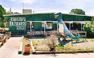
Dinosaur City on Route 66
Index to this page
About Grand Canyon Caverns, Arizona
Facts, Trivia and useful information
Elevation 5,500 ft (1.677 m). Population n ⁄a (2025).
Time zone: Mountain (MST): UTC minus 7 hours. Summer (DST) no DST⁄ PDT (UTC-7).
The Grand Canyon Caverns is located in Coconino County, in northwestern Arizona, on the historic Route 66 segment south of the Grand Canyon.
History
Visit our Peach Springs page for the History of this area
The Cavern system was discovered by chance when Walter Peck almost fell into a deep hole in 1927; heavy rain had widened a natural opening. Peck, who was a woodcutter returned to the spot the following day and with the help of some local cowboys explored the cavern he found some bones and shiny stones he thought contained gold.
He purchased the property with the idea of mining gold, but the rock contained worthless "fool's gold" or pyrite.
The Name: Grand Canyon Caverns
As it was close to the Santa Fe railroad siding of Yampai Peck named the spot Yampai Caverns. Later, under another owner it became Coconino Caves. Victor Leon in the late 1950s renamed the place Dinosaur City and Grand Canyon Caverns.

Your Hotel in Grand Canyon Caverns
Spend a night in the Caverns at its Motel (sponsored content):
>> Book your room in the Grand Canyons Cavern Inn
More Accommodation nearby along Route 66
There are plenty of lodging options in the cities and towns along Route 66 east and west of Grand Canyon Caverns; click on the links below to find your accommodation in these towns, listed from east to west:
Eastwards
In Arizona Along Route 66
Westwards
You are so close to Las Vegas and the Grand Canyon!
>> RV campgrounds in the Grand Canyon Caverns
The Weather in Grand Canyon Caverns
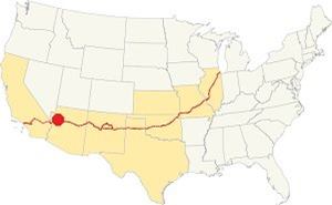
Location of Grand Canyon Caverns AZ on Route 66
Grand Canyon Caverns has a dry climate with almost 290 sunny days per year. There are 43 days with precipitation each year. The average summer High (Jul) is 97° (36.1°C), and the average low is 58°F (14.4°C).
It has a below freezing average temperatures in winter, with a low (Jan) of 27.8°F (-2.3°C). The average winter high is about 53°F (11.7°C).
It gets little snowfall: 3 in. (7.5 cm), and 11 inches of rain (280 mm) per year with most rain falling in summer (keep an eye open for thunderstorms).
Tornado risk
This part of Route 66, to the west of the Rocky Mountains has no tornado events. Tornado Risk: read more about Tornado Risk along Route66.
Map of Route 66 in Grand Canyon Caverns
Visit our Williams to Kingman page for the description of this alignment. Below is the color coded interactive map:
>> Custom map of Route 66 in Grand Canyon Caverns
The thumbnail map below published in 1935 shows the highway between Williams and Kingman. Notice that the Grand Canyon Caverns (GCC) don't appear on this map (they are roughly where "Cedar Grove" is located).

Thumbnail of the 1935 Arizona highway map. Source
Click on thumbnail map to enlarge
Notice that the highway had a four-lane divided section to allow a safe access to the GCC. This is the Map of US66 here.
Route 66 Alignment near Grand Canyon Caverns
With maps and full information of the old roadway.
- Kingman to Topock (next)
- Williams to Kingman (Grand Canyon Caverns')
- Winona to Williams (previous)
Sights and Attractions in GCC, Arizona
Historic context, the classic Route 66
When Jack DeVere Rittenhouse drove down Route 66 in 1946, researching for his "A Guide Book to Highway 66" he gave a brief outline of the towns and sights along the highway, yet he does not mention the Grand Canyon Caverns between Seligman and Peach Springs. His comment here, four miles east of Peach Springs is the following:
you start down a grade which drops about 250 feet in 2 miles. About halfway down this grade is a sign (R) stating that the lower end of the Grand Canyon can be seen in the far distance to the north (R). Rittenhouse (1946)
A Wacky Stop on Route 66
Driving west from Seligman, after 26 miles, to your right is the entrance to this classic wacky Route 66 attraction. We describe it below.
Grand Canyon Caverns
On the south side of the road is the access to "Grand Canyon Caverns Village", with a motel, gas station, and the famous caverns with dinosaur statues:
Geology and Formation of the Caverns
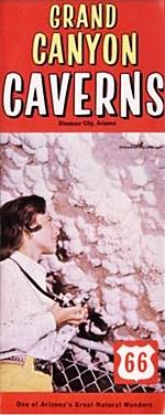
A 1960s brochure of the Grand Canyon Caverns. Source
Dry Sulfuric Karst Cave
The Grand Canyon Caverns are a type of cave known as "dry sulfuric karst cave". They are located in northwest Arizona, about 60 miles (100 km) south of the southern rim of Grand Canyon National Park.
Kärst means an area where limestone has been eroded to produce sinkholes, caves, cracks, tunnels, or caverns.
How the caverns were formed
The "Speleogenesis" (latin words for origin of the caves) of the Grand Canyon Caverns was provoked by water with high concentration of sulfuric acid. The sulfates contained by rocks are reduced in the presence of hydrocarbons and produce H2S or hydrogen sulfide a gas with a smell of rotten eggs. This gas dissolves into the water in the deep aquifers and rises through fractures in the overlying rocks towards the surface. On its way it oxidizes and becomes sulfuric acid. The limestone is dissolved by the extremely strong sulfuric acid, creating caves very close to the water table.
Type of Cavern & features
The caverns are dry, and have no pools or bodies of water. The temperature is on average 60°F (15°C) and the relative humidity is around 80%.
It has several attractions in its inner tunnels (see map - red arrow marks entrance), further down we describe the tours.
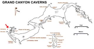
Map of the Caverns. Source
Click on thumbnail map to enlarge
The Geology of the GCC
The cave system is located in the upper layer of the Redwall limestone formation.
This rock is almost 99.5% limestone and its resistant rocks form red colored cliffs in the Grand Canyon where they are between 500 and 800 feet high (150 - 240 m).
They are 350 Million years old and date back to the Paleozoic Era, to the Late Devonian period. At this time Laurentia (the ancient rock core of what is now North America) was located close to the Equator and had merged with Baltica to form a large continent known as Laurussia or Euramerica. To the south, in the Southern Hemisphere was another vast continent, Gondwana, including what is now South America, India, Africa, Australia and New Zealand.
A shallow tropical sea bathed the coasts of Laurentia, and in the limestone was laid down in this sea. The redwall limestone contains many fossils of sponges, nautiloids, corals, and trilobites.
It receives its name due to its color, which comes from rainwater percolating through the overlying redbeds of rust-red Supai shale, colored with iron oxides.
The history of the Caverns
As we mentioned further up, they were discovered by chance when a heavy rainfall widened a natural sinkhole and Walter Peck, a woodcutter of the Santa Fe railroad almost fell into it.
He returned with some men and using a rope and a lantern explored the cave below. It seemed to shine in the dark and he thought he'd found a gold mine.

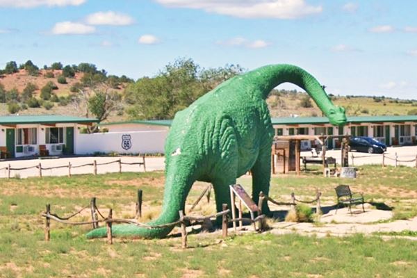
"Zoomie" the apatosaurus.
As the caverns were close to the Santa Fe railroad siding of Yampai, he named the spot Yampai Caverns. Peck purchased the property with the idea of mining gold, but the rock samples that he had analyzed contained worthless "fool's gold" or pyrite.
An entrepreneur, Peck changed his plans on the go, and started charging 25 cents for tourists to visit the "cavmen" in the cavern.
These cavemen were actually the remains of some Hualapai natives who had been buried here in 1917.
For years visitors descended one at a time using a primitive rope and pulley system: the locals called it Walter Peck's "dope-on-a-rope tour."
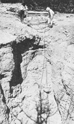
1938 view of the cavern's winchsystem. Source
Some time during the 1930s they were renamed "Coconino Caverns" and shortly after, in 1936, the Civilian Conservation Corps program built a wooden staircase allowing more people to visit the site (the fee went up to 50 cents) at that time it was operated by Stanley Wakefield. who leased them from the state and also operated "Deer Lodge" a service station on Route 66. The black and white photograph shows the original winch system as it stood in 1938.
According to Stan "... some Mexican sheep herders discovered a well-like opening on the surface of the hills" (1).
But Stan didn't renew his lease: In 1948, an advertisement in The Desert Magazine sought investors to run the attraction: "Want to Own a Cavern? - PHOENIX - Ready and waiting for development by someone with from $ 75,000 to $ 100,000 are the Coconino caverns , just off U.S. Highway 66 between Peach Springs and Seligman. The caverns are on state land, have never been fully developed..."
Dinosaur City
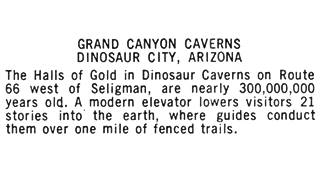
Back of a postcard Source
The place was renamed once again in 1957, now it became the "Dinosaur Caverns".
Under new ownership in 1962, a new shaft was blasted in the limestone and an elevator was installed. The place was called "Grand Canyon Caverns" and the motel, caverns complex and gas station became "Dinosaur City" as you can see in the image with the postcard text.
The Dinosaurs
During the cold war years from 1950 to 1960 there was a dinosaur-mania period that saw several dinosaur movies released: Journey to the Center of the Earth (1959), Dinosaurus! (1960), The Beast of Hollow Mountain (1956), The Giant Behemoth (1959), The Land Unknown (1957) and the Lost World (1960). This probably prompted Victor Leon to rename the spot Dinosaur City and place dinosaur statues here. One of them is a 12-foot tall T-Rex, and it is still here guarding the entrance to the caves, below is a "Then and Now" sequence:
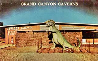
T-Rex in a 1960s postcard. Source
There are several dinosaurs in the park. Zoomie, pictured below was originally from San Juan Capistrano CA, but it had to move due to city regulations. The Park bought it, reassembled it on site and painted it bright green. It is an apatosaurus, formerly known as Brontosaurus, a herbivore dinosaur (2):
The Caverns
Giant Ground Sloth
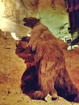
Ground sloth replica. Source
The cave system is located 1.1 miles to the south of the highway. Now it is managed by the Hualapai Indian Nation, and it receives 70,000 visitors each year. Route 66 was widened to a four-lane divided roadway here in the 1960s due to the large amount of visitors.
In the caverns were rated by the National Caves Association as Category B in the 1970s. During your visit you can see the mummified 150 year-old remains of a bobcat, a re-creation of an 18,000 year old Ground Sloth ( Megalonyx jeffersoni), whose bones were found in the cave. And tour the caverns 200 - 300 feet below the surface.
Tours: visiting the Caverns
There are several tours, the most common one is a 45 minute tour that is 3 ⁄ 4 mile long. It begins with a 200 foot descent into the cavern using the elevator and a view of its attractions: "Winter Crystal", "Cave Coral", "Grape Clusters", "Halls of Gold", "The Devils Den", "Snowball Palace", "Mammoth Dome", fossils and ancient waterfalls. The walkways are paved and have handrails.
There are other tours for those seeking more adventures including a hotel room inside the caverns, 200 feet below ground level - it costs $900 per night for two guests.
Read more at the Cavern's website or book a tour:
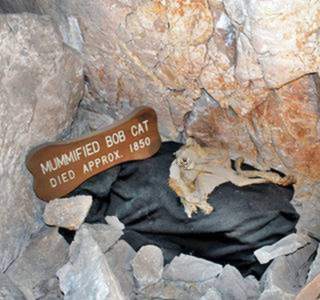
Bobcat mummy in the Caverns. Source
Trivia
The caves were once designated as a fallout shelter in the event of a nuclear strike on the US.
A cosmic ray detector was placed in the caverns in 1969 as part of a research project of the University of New Mexico (3)
The 1960s Motel
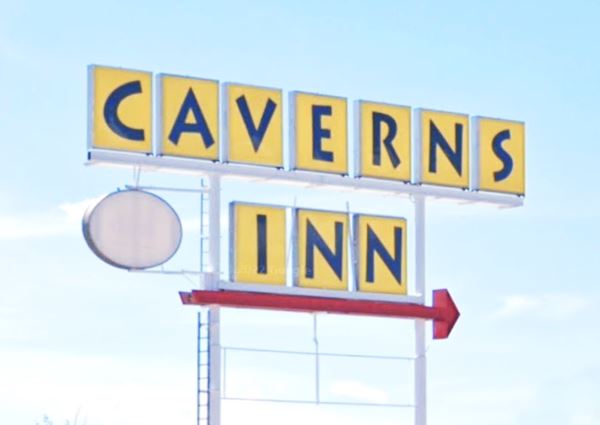
The original motel was the Best Western Parks Motel, the building is still standing and is the "Grand Canyon Caverns Inn":
>> You can Book a Room in this motel.
The 1960s postcard below boasted: "Park Motel - Dinosaur City, Arizona - Telepone: Dinosaur #1 - At the entrance to the fabulous Grand Canyon Caverns on Hwy. 66, 65 miles east of Kingman, 25 miles west of Seligman. 48 new units, room phones, T.V., refrigerated. Pool, tennis, shuffle-board, playground. Coffee shop and Lounge. Gift Shop. 4,200 ft. runway. Service Station."
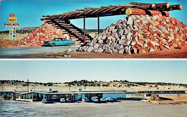
The massive rock pyramids of the entrance portico are still there.
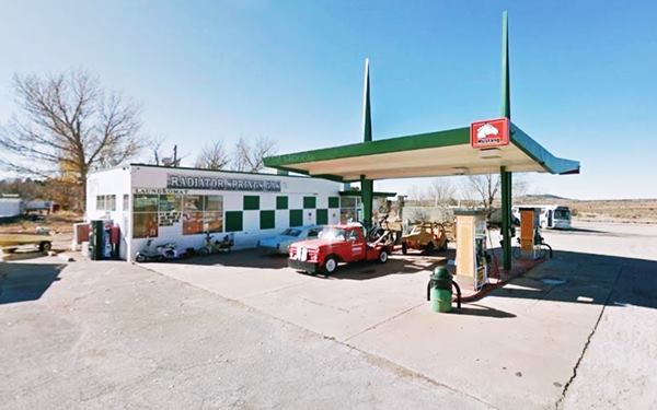
Radiator Springs service station
On the western side of the complex is the gas station mentioned in the postcard. It is an early 1960s Chevron station according to one postcard. It has an oblong box style with a modern space age 1960s canopy, it is a butterfly shaped wing, held up by two steel poles that pierce it.
It has been repainted and it sells Mustang brand gasoline. It was also named after the imaginary town in the movie "Cars" released in 2006.
Return to the highway and continue your Route 66 Road Trip by driving west towards Peach Springs.
Continue your Road Trip
This marks the end of your Route 66 road trip in the Grand Canyon Caverns, head west and visit the next stop on your journey: Peach Springs.
Outdoors, National and State Parks
Diamond Creek and the Grand Canyon
The Grand Canyon and the Colorado River are located to the north of Peach Springs 15 miles (25 km) as the crow flies.
The Grand Canyon gorge here is 2,000 ft. (600 m) high and Diamond Creek, an intermittent stream, flows into the Colorado River at this point, flowing through the Hualapai reservation.
It was for many years the main tourist spot on the Grand Canyon, as it was one of the few places where the Colorado River itself could be reached easily, and there was a hotel at this spot, the Diamond Creek Hotel.
All this came to an end when the railway link was built between Williams and the Grand Canyon in 1907.
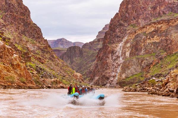
The Diamond Creek Road (dirt & gravel road) runs along the creek's canyon and provides the only access to the Colorado River between Lees Ferry and Pierce Ferry. The Hualapai tribal government charges a fee for all vehicles and people traversing the road (about $30 ⁄ person). Map of the road (30 mi. from the Cavern)
Be careful with Flash Flooding during the rainy period. It can be dangerous and damage the road. The road is better suited for SUVs (don't take a rented vehicle along it as it may violate your rental contract).
Hualapai River Runners
Diamond Creek on the Grand Canyon is where the whitewater rafting trips start out from; you can book one-day Colorado River trips or whitewater rafting tours at the Hualapai Lodge. From March through October.
See a 360° view at Diamond Creek on the Colorado River
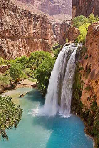
Havasu Falls. Source
Supai and Havasu Falls
Further away (75 mi from Peach Springs) - Map of the part that can be driven, The final part of the journey is a 9.2 mile-long trek from the parking lot (trek map) are the famous Havasu Falls are located, close to the village of Supai, Arizona, in the Havasupai Reservation, close to the Grand Canyon's South Rim. The falls are pictured above.
The Hualapai Tribe
The Hualapai Tribe is a federally recognized Native American Tribe. "Hualapai" (pronounced Wal-lah-pie) means "People of the Tall Pines".
The Hualapai reservation was created in 1883, and covers one million acres, spanning the counties of Coconino, Yavapai and Mohave. It borders the Grand Canyon to the north and is home to 1,621 residents, of which 1,353 are tribal members. Another 1,000 Hualapai live off the reservation.
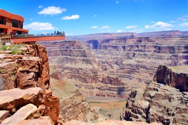
There are tour packages with great views from the Skywalk (a glass bridge that enables visitors to walk beyond the rim of the Grand Canyon at 4,000 feet (1.200 m) above the Colorado River).
The Grand Canyon Skywalk
90 mi. See the Map with Directions.
Opened in 2007 it is within the Hualapai Tribal land. It is a transparent horseshoe-shaped bridge that curves out and above the Grand Canyon 4,770 ft (1.450 m) above the Colorado River.
The best way to reach it is taking a tour as the roads are not in top conditions.
Read more at the Skywalk website.
Grand Canyon Skywalk
Some sponsored content
Lake Havasu City

Lake Havasu City, the lake and London Bridge. Source
The resort town of Lake Havasu City on Lake Havasu has beaches along the lake's scenic shoreline, an active nightlife and the original London bridge (you can take a Tour to visit it)
The adjacent state park is open 24 hs, and there is an entrance fee. It is located on a reservoir on the Colorado River. You can hike and enjoy the riverside.
Visit the scenic shoreline with beautiful beaches, nature trails, boat ramps, and many convenient campsites.
>> Book your Hotel in Lake Havasu City
Learn more about the outdoor sites in the Havasu State Park official website.
>> Book your Hotel in Grand Canyon Caverns AZ


Credits
Banner image: Hackberry General Store, Hackberry, Arizona by Perla Eichenblat
Jack DeVere Rittenhouse, (1946). A Guide Book to Highway 66.


