

Truxton, Route 66
Index to this page
About Truxton, Arizona
Facts, Trivia and useful information
Elevation 4,347 ft (1.326 m). Population 120 (2025).
Time zone: Mountain (MST): UTC minus 7 hours. Summer (DST) no DST⁄ PDT (UTC-7).
Truxton is a very small village in western-central Mohave County, in the northwestern part of Arizona.

Mr. Truxtun Beale
For the older history of this area, check our Peach Springs page, which tells about the Hualapai natives and the Spanish-Mexican period.
After Mexico ceded the territory to the U.S., the government sent, in 1851, Captain Lorenzo Sitgreaves (1810 - 1888) to explore New Mexico and Arizona and survey the Zuni and Colorado Rivers. He went through what is now Truxton and camped there, writing in his diary: "This rivulet which I have called the Yampai has its source in three small springs..."
In 1857 the U.S. government commissioned Lt. Edward "Ned" Fitzgerald Beale (1822-1893) to survey and open a wagon trail from Ft. Smith (Arkansas) to California.
He used camels, imported from Tunis as pack animals in his expedition. Though hardier than mules, the camels scared both horses and mules. The Army decided not to use camels in the future.
Beale followed Sitgreaves trail, passing through the same springs which he named "Truxtun", after his son, pictured above.
After the Hualapai natives were defeated by the U.S. Army in the 1870s, they were placed in a reservation. This opened the way for the Atlantic & Pacific Railroad (which later became the Atchison Topeka and Santa Fe Railroad) built a railroad through the area.
The A&P railroad set up a stop at Truxton, but moved the tracks to higher ground after the floods of 1904.

The first highway through the area

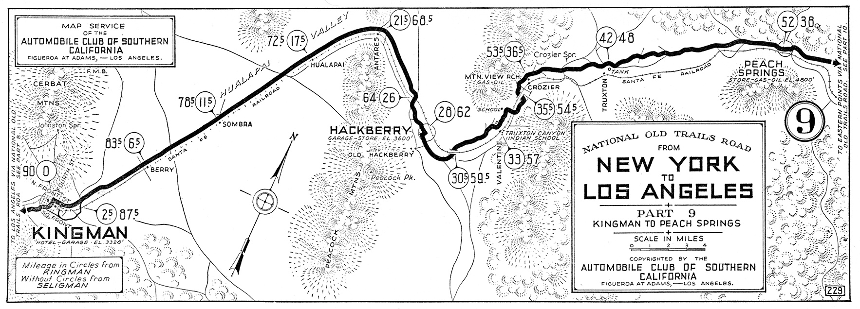
1923 National Old Trails map at Truxton (red arrow)
Click image for larger full map
from Peach Springs to Kingman. Source
As an initiative to improve roads and make them permanent and easier to use with automobiles, the National Old Trails highway was built gradually, in the 1910s, from California eastwards into Arizona and New Mexico.
This original highway, passed through Truxton as you can see in this 1923 map.
Crozier Spring (the one mentioned by Sitgreaves and Beale) can e seen and also Truxton railway siding (red arrow).
To the south was Valentine with its Historic Valentine School (Truxton Canyon Indian School in the map).
In 1926 Route 66 was aligned along the dirt surfaced N.O.T. highway.
Truxton is set in the place where the wide valley of the Yampai River narrows into Truxton Wash, and becomes a granite gorge (Crozier Canyon).
This granite extends to the north to the foot of Music Mountain, a high peak which very prominent, seven miles away from Truxton. It is the southwestern corner of the Grand Wash Cliffs.
The Name: Truxton
Truxtun Beale (1856 – 1936), son of Edward Fitzgerald Beale and Mary Engle Edwards. He was an American diplomat. Named after his grandfather, Commodore Thomas Truxtun.
It is a compound of Old English and Old Norse, and this took place when a Viking occupied the manor or a village. "Trux" or "Thrux" derives from an old Norse name "Thorkell", while the prefix "ton" is Old English for "farm", "settlement", or "village".
The name was later deformed -changing the "u" into an "o", and became "Truxton".
The village was a latecomer to Route 66
Clyde McCune and Donald J. Dilts opened a service station and garage in Truxton in 1951, and chose a spot close to the head of Crozier Canyon and just south of the Hualapai Reservation's boundary.
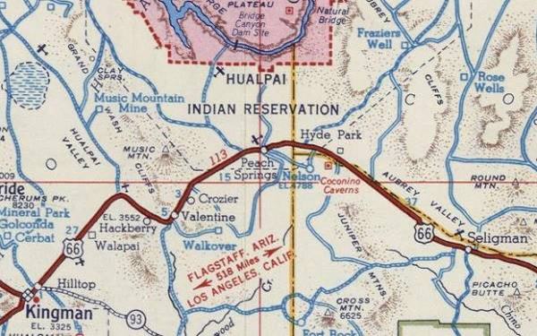
They had heard that a dam would be built on the Colorado River at Bridge Canyon, and expected that the road that would lead to would start off from Route 66 at Truxton siding. The map below shows the "Bridge Canyon Dam Site" in the pink colored area. They named the place Truxton after the railroad siding closest to their establishment.
Truxton had been born.
A 1951 roadmap of the Seligman to Kingman US 66, Truxton does not appear (it was founded that year).
Others followed them and even though the dam was never built, the place boomed until I-40 bypassed this section of U.S. 66 in 1979. Now only a few businesses cater to the local traffic and Route 66 roadtrippers.
Where to Stay near Truxton
Spend a night in Peach Springs, next to Truxton, at the Hualapai Lodge.
>> Book your Hotel in neighboring Peach Springs
More Accommodation near Truxton on Route 66
There are plenty of lodging options in the cities and towns along Route 66 east and west of this town; click on the links below to find your accommodation in these towns, listed from east to west:
Eastwards
In Arizona Along Route 66
Westwards
You are so close to Las Vegas and the Grand Canyon!


>> RV campgrounds in neighboring Peach Springs
Weather in Truxton

Location of Truxton AZ on Route 66
Truxton's weather is dry and sunny. Hot in summer and cold in winter. There are some 280 sunny days every year.
Average temperatures in summer: Highs (Jul) 97° (36.1°C) and lows 58°F (14.4°C). Average temperature in winter: Low (Jan) of 27.8°F (-2.3°C)
and high 53°F (11.7°C).
Not much snow falls in Truxton: some 3 in. (7.5 cm). Rainfall is about 11 inches (280 mm) yearly with summer being the rainy season.
Tornado risk
There are no tornados in Truxton because there are hardly any tornados west of the Rocky Mountains.
Tornado Risk: read more about Tornado Risk along Route66.
Map of Route 66 in Truxton Arizona
Visit our Williams to Kingman Alignment page for a detailed description of Route 66 across Truxton. Below is the color coded interactive map:
>> Custom map of Route 66 in Truxton

Thumbnail of the 1935 Arizona highway map. Source
Click on thumbnail map to enlarge
Visit our Route 66 Map of Arizona and you will find Truxton and all the other towns located along the Mother Road in AZ. The map also shows the different alignments of US 66 over the years.
Check this map with US 66 alignment in Truxton and our custom map showing the sections that survive, but can't be driven (marked with a purple line, west of Peach Springs).
Getting to Truxton
You can reach Truxton along Historic Route 66 in Arizona from Seligman (east) or Kingman (west), both of these towns lie on I-40.
Route 66 Alignment near Truxton
With maps and full information of the old roadway.
- Kingman to Topock (next)
- Williams to Kingman (Truxton's)
- Winona to Williams (previous)
Things to see and visit in Truxton
Atractions, outdoors and Activities
Truxton is Almost a Ghost Town
Historic context, the classic Route 66 in Truxton

1966 USGS map of Truxton
When Jack DeVere Rittenhouse drove down Route 66 in 1946, before writing his classic "A Guide Book to Highway 66" he did not mention Truxton because at that time it had had not yet been established. The oldest service stations and motels in town are from the early 1950s.
Nowaday's there is not much of a "city" to tour in Truxton. You can drive along Route 66 and take in all the sights stopping along the way. Our itinerary starts at the eastern tip of town, at the bridge over the dry creek, at mile post 95.
Use the map with the numbers (1) to (10) in it to follow our itinerary across Truxton.
Old Service Station Texaco, or Chevron?
It is (1) in our map. Actually, the building does not appear in the map, only the old garage behind it. So it is more recent than 1966.
To your right, on north side of the road, you will see a 1970s service station with a flat steel canopy held up by two sets of steel posts.
The canopy covers two sets of gas pump islands. We have called it Gas Station #1, because there are different versions of what brand of gasoline it sold.
The Arizona Dept. of Environmental Quality lists the gas station as follows: "TRUXTON CHEVRON - FORMER, 15961 E HWY 66, TRUXTON, Mohave." This address coincides with this station.
Chevron was the name adopted bu Standard Oil of California after 1972, and it phased out its original brand. Standard had used "modern" sleek gas stations since the 1950s and they look very similar to this one in Truxton. Check out these images: Utah Standard Station ca. 1960, Arizona Standard Station 1950s, Standard Station late 1960s.
What is baffling is the white steel signpost next to the highway, with a curved upper cradle, which is missing the sign, but from the shape of the post, could have been a Texaco signpost, but it was not the type used in the late 1960s.
The building has two bays and is no longer a gas station. It was known recently as Sudberry's Southland Service Station, operated by Mike Sudberry. Behind it is a former garage which now is a home, which figures in the 1966 map.
An old service station on Route 66 in Truxton Arizona. Click image for Street View

Former Shamrock Oil gas station
(2) in our map. To the west, next to the former Chevron Texaco is another empty building. We know it is a gas station because as you can see in the image, it has two concrete gas pump islands. There is only a small office and no garage.
Below are two picturess: a street view of it nowadays, and a detail from a larger photo looking east from the Truxton Café.
The second picture is revealing; it shows the original Truxton Texaco and, next to it, to the east, this gas station and we can see the office, the pumps and the Shamrock oil sign (red arrows).

Shamrock Gas Station, Truxton. Click for Street View

1950s photo of the Shamrock gas station in Truxton
Shamrock Oil and Gas was founded in 1929 by J. Sheerin. Its logo was round and had a green three-leaf clover with the word "Shamrock" in the center.
It owned its own refinery and a chain of service stations in the Southwest. In 1967 it merged with another refiner forming Diamond Shamrock Corp. In 2001 it was acquired by Valero.
Just beside the old Shamrock is the Original Site of the Truxton Texaco Station.
Original Site of the Truxton Texaco gas station
This is (3) in our map. The building is no longer there, it has been torn down, but its foundations can stil be seen, between Truxton Café to the west, and the old Shamrock station to the east.
The following photograph from the 1950s, the Café is on the left, the Texaco in the middle, and the Shamrock to the right.
Original buildings in Truxton Arizona ca. 1955

The old corrugated sheet metal building still sported Texaco's red and white colors before it was torn down.
Original buildings in Truxton Arizona ca. 1955

The image above shows it before it was torn down. Lower right are the islands of the adjacent Shamrock station.
Foundation Site of Truxton
This is the site where the town of Truxton was "founded". The first buildings were the Café and the now gone Texaco service station.
Donald J. Dilts who had come to Arizona as a supervisor on the Santa Fe Railroad, partnered with Clyde McCune and opened the Truxton Garage, which was a success. So it was followed by the Cafe and Texaco service station in 1951.
This was the official beginning of the Truxton. Click on images below for their Street View

Truxton Cafe nowadays

Satellite view Truxton Café and gas stations
Truxton Café
Next to the site of the old station is a masonry building with a gabled roof, the original Truxton Cafe (established by Dilts). Now it is closed and abandoned.
Head west to corner to see the Barker Apartments:
Barker Apartments
At Route 66 and Molthan Ln. On the northwest corner is the abandoned building ((4) on the map) which was built in 1953 and operated for some years as a motel. Later it was purchased by the Barkers who rented its apartments to the locals.
The Barkers
Mildred Jane Barker nee McCartney was born in 1925 on Route 66, in Sayre Oklahoma, one year before it was created. She passed away in Kingman in 2012.
She married Raymond Barker, a former marine during WWII in 1947 and in 1952 moved to neighboring Peach Springs AZ. Finally, in 1957 the couple settled in Truxton.
They first owned the Mobil Service Station and Diner, and also the adjoining Barker Apartments -named after them. Later they bought the Frontier Motel & Café across the road.
See this Street View of the Neon Sign and old Motel.
The motel, perpendicular to Route 66 is still there, though closed, and its faded neon sign painted blue with white letters is standing in front of it. On its west face, the underlying and faded blue lettering advertises the 'LAZY Z MOTEL Electric Heat', whilst the white proclaims the 'BARKER APARTMENTS'. The more lightly weathered white lettering on the east face reads as 'BARKER APAPMENTS' yes, with a "P" and the blue background is almost gone.
Fading, peeling neon sign of the Barker Apartments

Beside it, to the west, is the former cafe and gas station of the Barkers.
Former Mobil station - Bell Gas

Bell Gas Signpost. Carol Highsmith
Beside Barker Apartments is another "former" service station,(5) in our map.
Until the early 1990s it sported the sign of a Mobile Gas station, and had been one for many years; an advertisement in the March 1957 Arizona Highway Patrol magazine
read "TRUXTON MOBIL SERVICE - TRUXTON, ARIZONA."
At some time it became a Bell Gas station. Bell Oil at one time sported a red bell on its signs, later replaced with a yellow one, followed by the word "Bell".
The sign still proclaims "Gas", but the image of a yellow bell which once was the brand is now gone on one side of the sign; the panel is broken.
Below is a "Then-and-Now" sequence of the former diner and gas station:
A 1950s photo of the gas station

Same place today (see street view)

Cross the road to visit another defunct service station.
Another Service Station
The white building, (6) in our map, lacks a canopy, but the area where the gas pumps once stood can be clearly made out.
There is a one-bay garage and a steel post that at one time sported a sign -now gone.
This is a Street View of the old station.
Unnamed Service Station in Truxton

The car in the image is a 1955 Dodge Royal Lancer. Next to it, to the west, is the famous Frontier Motel.
Frontier Motel
At 16118 Route 66. This is marked with number (7) in our map. This is a classic Route 66 motel with flamboyant signage and all! The Frontier was built by Alice Wright in 1952, and it included a café and the motel which had 9 units and an "I" shaped layout.
According to Michael Wallis and Marian Clark, Alice Wright believed in the supernatural, and when a clairvoyant told her to drive 400 miles from Los Angeles and open a Café she did it, and opened "Truxton Café" and the motel exactly four hundred miles from her home.
In 1957 it was purchased by Ray and Mildred Baker (who owned the motel and gas station across the street). Th Barkers would later work actively in the rebirth of Route 66, through the Historic Route 66 Association of Arizona.
Check out this Street View of the Frontier Motel.

Cross back to the north side of the road and visit the Truxton Service Station.
Truxton Service Station

Truxton Station, nowadays
This service station opened in the early 1950s and at one time was a Withing Brothers gas station. It is marked (8) in our map.
Unlike all the other gas stations in town, this one is still open, selling gasoline. See its street view.
Below is a photograph taken in the 1950s(?) from the Barker's Mobile looking west. You can make out the Whiting sign behind the people in the foreground, and the box shaped canopy that is still sheltering the pumps (red arrow).
Whiting Gas Station in Truxton

Read more about Whiting Bros. & Route 66
Tommy Eleamon ran the Whiting Bros. Station 42 in Truxton, and published an advertisement in the March 1957 Arizona Highway Patrol magazine.
It later became an Enco station and in the early 1980s a Mobil station as you can see in this photo from 1983.
Cattlemen's Cafe site
Next to the station are the remains of the foundations of the former Cattlemen's Cafe. (9) in our map. It was owned by John and Howard Grounds, open 24 hours, its postcard said "We Raise Our Own Beef".

Ruins of the Cattlemen's Café. Click for Street View

1950s postcard of the Cattlemen's Cafe, Truxton
The outline of the old circular counter and the round steel bases of some of the bar stools are still visible on the floor.
Head west for 0.2 miles and, also on the right side of the road is an abandoned motel, the Orlando Motel, (10) in our map.
The Orlando Motel
This is another classic Route 66 motel, date unknown, but you can see it in the following set of "Then and Now" photos:

There is more greenery around the building, it has lost its canopy and although the sign is the original one, it lost its upper 1960s googie-style "spikes".
The same spot, with the remains of the Orlando Motel on Route 66 today

Click for St. View
Was it named after William Shakespeare's character "Orlando" in the comedy"As You Like It" (1599)?
This ends the tour of Route 66 classic sights in Truxton, but there is a bonus attraction just ahead. A modern one, dating back to 2006, with gas,food and some good spots to take photos.
The Cowgill's Trading Post - signpost
The modern Gas & Grub which opened in 2006 replaced the former Cowgill's Trading Post which was the site of a famous "Cowgill's" sign post.
Below is a photo taken in 2009 of the post, topped with a Route 66 shield with the word "Cowgills".

The new signpost reads "Gas-n-Grub", and is a very good replica of the orignal one as you can see in the following image.

The list of ten cities on the sign has changed and only Oklahoma City, Amarillo, Flagstaff and Kingman appear on both signs.
Continue your Road Trip
This marks the end of this part of your journey along the Mother Road. Head west and visit Valentine to continue your Route 66 Road Trip!
Outdoors, National and State Parks
There are many outdoor places to enjoy nature nearby: starting from neighboring Peach Springs you can visit the Grand Canyon and go rafting along the Colorado River at Diamond Creek. You can take a tour and visit the Grand Canyon Skywalk and the Hualapai Mountain County Park.
The Grand Canyon Skywalk
83 mi. See the Map with Directions.
Opened in 2007 it is within the Hualapai Tribal land. It is a transparent horseshoe-shaped bridge that curves out and above the Grand Canyon 4,770 ft (1.450 m) above the Colorado River.
The best way to reach it is taking a tour as the roads are not in top conditions.
Read more at the Skywalk website.
Grand Canyon Skywalk


Some sponsored content
Lake Havasu City

Lake Havasu City, the lake and London Bridge. Source
The resort town of Lake Havasu City on Lake Havasu has beaches along the lake's scenic shoreline, an active nightlife and the original London bridge (you can take a Tour to visit it)
The adjacent state park is open 24 hs, and there is an entrance fee. It is located on a reservoir on the Colorado River. You can hike and enjoy the riverside.
Visit the scenic shoreline with beautiful beaches, nature trails, boat ramps, and many convenient campsites.
>> Book your Hotel in Lake Havasu City
Learn more about the outdoor sites in the Havasu State Park official website.
>> Book your Hotel in Peach Springs AZ
Credits
Banner image: Hackberry General Store, Hackberry, Arizona by Perla Eichenblat
Jack DeVere Rittenhouse, (1946). A Guide Book to Highway 66.