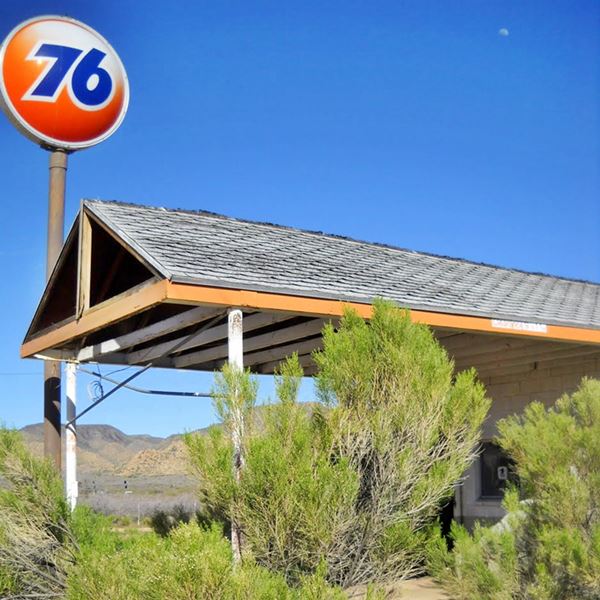
The site of Valentine post office
Index to this page
About Valentine, Arizona
Facts, Trivia and useful information
Elevation 4,347 ft (1.326 m). Population 58 (2025).
Time zone: Mountain (MST): UTC minus 7 hours. Summer (DST) no DST⁄ PDT (UTC-7).
Valentine is a very small village in central Mohave County, in the northwestern part of Arizona, located on Route 66.
History
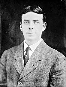
Robert G. Valentine: the town was named after him
For the prehistoric and Spanish - Mexican history of this area, check our Peach Springs page.
After the U.S. took this territory from Mexico, the government commissioned Captain Lorenzo Sitgreaves (1810 - 1888) to explore what is now Valentine (1851). He was followed by Lt. Edward "Ned" Fitzgerald Beale (1822-1893), who surveyed a wagon trail in 1857, to link Arkansas with California.
Once the local Hualapai natives had been defeated and relocated in a reservation, the railway built its tracks along Beale's trail through what would become Valentine (1883).
Settlement began with the opening of the Truxton Canyon Training school (we it describe further down).
The many names of Valentine
The canyon and the station (1898) and later (1901) the Post Office at the School, were known as Truxton, in turn named after the springs that fed the stream flowing through it.
The spring in turn had been named by surveyor Edward Fitzgerald Beale in 1857 after his son Truxtun Beale (1856 – 1936); named after his grandfather, Commodore Thomas Truxtun. Later "Truxtun" became Truxton.
The Route 66 town of Truxton did not exist in those days as it was founded in 1951.
In 1910, the township near the School and the shool site was renamed Valentine, after Robert G. Valentine, who had been the Commissioner of Indian Affairs from 1909 to 1912.
The first highway

1923 National Old Trails map at Valentine (detail)
Click image for larger full map
from Peach Springs to Kingman. Source
The first road built for cars, the National Old Trails highway (N.O.T.) passed through Valentine in the 1910s.
The map in the image (click on it to see the full Peach Springs to Kingman large size map), shows the N.O.T alignment through Valentine, which appears next to the "Truxton Canyon Indian School".
Further north is the siding of Crozier, and Mountain View Ranch (which offered drivers gas and oil). Crozier Sprs. to the east is where modern Truxton is located.
Three years after this map was published, Route 66 was created (1926), providing a steady flow of travelers through the community until it was bypassed by I-40 in 1979.

Where to Stay near Valentine
Spend a night in Peach Springs which is very close to Valentine:
>> Book your Hotel in neighboring Peach Springs
More Lodging Near Valentine along Route 66
There are plenty of lodging options in the cities and towns along Route 66 east and west of Valentine; click on the links below to find your accommodation in these towns, listed from east to west:
Eastwards
In Arizona Along Route 66
Westwards
You are so close to Las Vegas and the Grand Canyon!
>> RV campgrounds in neighboring Peach Springs
Weather in Valentine
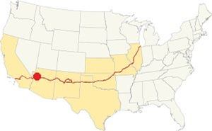
Location of Valentine on Route 66
The weather in Valentine is sunny and dry. Summers are hot and winters cold. It has around 280 sunny days per year.
Average summer temperature: High (Jul) 97° (36.1°C) and low 58°F (14.4°C). Average winter temperature: Low (Jan) of 27.8°F (-2.3°C) and high 53°F (11.7°C).
Not much snow falls in Valentine, some 3 in. (7.5 cm). Rainfall is around 11 inches (280 mm) yearly, with summer being the rainy season.
Tornado risk
As it is west of the Rocky Montains there are virtually no tornados in Valentine. Tornado Risk: read more about Tornado Risk along Route66.
Map of Route 66 in Valentine, AZ
Visit our Williams to Kingman Alignment page for a detailed description of Route 66 across Valentine. Below is the color coded interactive map:
>> Custom map of Route 66 in Valentine
A 1951 roadmap of the Seligman to Kingman US 66, Truxton does not appear (it was founded that year).
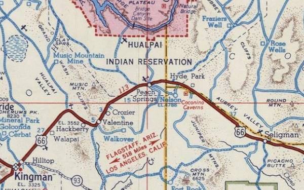
See this Map with US 66 Historic alignment in Valentine. We also marked the older 1926-37 alignment with a pale green line in our custom map.
The National Old Trails highway created in the early 1900s ran next to the railroad from Williams to Kingman. Route 66 was aligned along it in 1926.
Route 66 Alignment near Valentine
With maps and full information of the old roadway.
- Kingman to Topock (next)
- Williams to Kingman (Valentine's)
- Winona to Williams (previous)
Sights and Attractions in Valentine, Arizona
What to Do, Places to See
Valentine has the well known Valentine Post Office which postmarked thousands of letters on Valentine's Day, the Historic school, the remains of Chief's Motel, the site of the 7-V Ranch Resort at Crozier Canyon, and some old service stations like the Union 76 and the modern Valentine Gift Shop.
Historic context
Jack DeVere Rittenhouse drove the whole of Route 66 gathering information for his book, published in 1946 ("A Guide Book to Highway 66"), of course he drove by Valentine and mentioned it.
He noted the change from the relatively flat area east of Valentine to the abrupt relief at Crozier Canyon, there the "road begins to wind through" the Canyon.
Rittenhouse mentioned Crozier Canyon as "a settlement down in the canyon" and notes that the older alignment of Route 66 "ran through this canyon community", he pointed out that there was a swimming pool at the former resort.
He also added that the road has several cuts along the canyon. Regarding Valentine, he places the post office 16 miles west of Peach Springs and stated the following:
you pass VALENTINE post office. There is a gas station, grocery and a few cabins here... Valentine Indian School (R). Long distance telephone station heere. The school was built about 45 years ago, and provides education for over 200 Indians from nearby mountains Rittenhouse (1946)
The school was 2 miles further down the road from the post office.So the modern village of Valentine right beside the school is not the classic Route 66 community. The location of the 1946 village was two miles further north, at what is now (see Map) the Keepers of the Wild Nature Park.
We will tour Valentine from east to west, coming from Truxton.
Crozier Canyon
The old canyon has the remains of a resort; it is located 3.2 mi. north of the historic Valentine school and 6.2 miles west of Truxton (Map with directions).
Ghost Town and Former Resort
Elevation 3,971 ft. (1.211 m). Pop. zero.
Crozier Canyon wasn't a town or even a village, it was a resort and railroad siding. It was located on the trail followed by Beale during his 1857 expedition to California to survey a transcontinental railroad. The first settlement here was a ranch, later known as Crozier Canyon Ranch, established on the Beale Wagon Trail in 1872. Owned by Sam Crozier. The ranch itself was built in 1887.
The Name: Crozier
The place was named after the territorial legislator Sam Crozier (1840-1901), who purchased the land in 1880. He had found the Hackberry Mine to the west of Crozier.
This canyon is carved in granite and topped with layers of lava, fillin valleys and ridges. It was a rather recent (in geological terms) event. Truxton wash cut through it deeply forming Crozier Canyon.
The canyon had a convenient grade for the railroad so the tracks followed it. Hoewever, the stream that carved the canyon, which was mostly dry, flooded in 1904 and led to the relocation of the tracks in higher ground.
Old 1930s bridge
As the highway reaches the hills, it crosses Crozier Creek, that comes from your right, to the northwest from Crozier Spring. To your left you can see the old concrete bridge on the pre-1937 US 66 alignment. The modern alignment was built on higher ground (to avoid the flooding).
This is now private property so please do not trespass.
The 1937 Crozier Creek flood badly damaged Route 66 and devastated most of the complex downstream.
Route 66 was realigned to the west, along its current roadbed, on higher ground, bypassing the site, which rebuilt in part later housed railroad workers before being shuttered.
The 7-V Ranch Resort
The National Old Trails (N.O.T.) highway was also built along the Canyon, following the railroad in 1913. It was then that the new owners of the property, the Grounds, built a tourist resort for the wary travelers.
The green spot, with trees next to the dry wash had a swimming pool and a rest area for picnics.
Route 66 was aligned on the N.O.T. in 1926 and as traffic increased, the complex expanded to cope with it.
Edward Carrow built eight cabins with two units each, on the western side of the resort. The complex was named "7-V Ranch Resort" or "7-V Bar". There was a even bus stop there.
The cabins can still be seen and are now used as storage sheds. The other buildings lie on private property, as does the old Route 66 bridge north of the cabins.
The last segment of Route 66 to be paved in Arizona was the one by the mouth of the canyon, in 1937.
A 1930s postcard showing the resort on Route 66 in Crozier Canyon
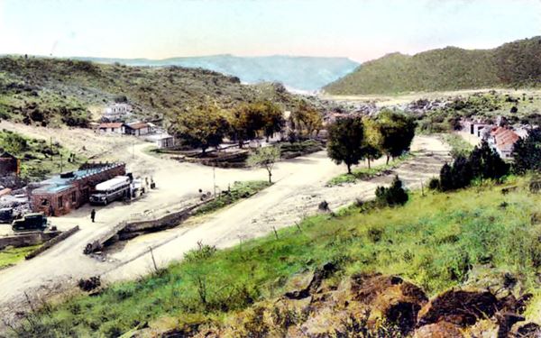
The postcard above looks south towards Valentine and Hackberry. It shows the dry stream and the bridge (front left) with the bus stop next.
Modern Route 66 passes by the point where this view was taken from.
To the right of the image are some red-roofed cabins, that are still there as you can see in the following image, taken nowadays and looking north:
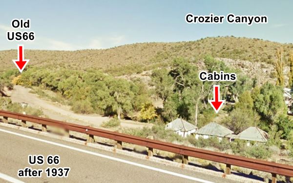
Township of Valentine
As the "Indian" school was located within the limits of the Truxton Canyon Indian reservation, commercial enterprises were banned by the subagency and federal regulations: they were prohibited close to Indian schools.
So the local entrepreneurs established themselves beyond the "reservation" in the township mentioned by Rittenhouse, 2 miles north of the school, and also, to the south of it. The current village next to the tracks developed much later.
Oasis Store
Original Location of Valentine AZ
Drive one mile east along US66 to see the site of the first building in Valentine; a stop named "Oasis Store" as it was located beside a spring.
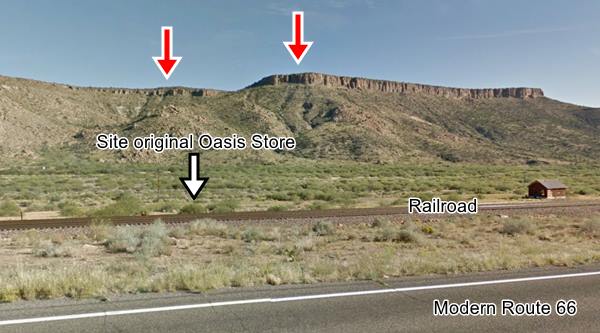
The store, garage and service station moved about following the changing alignment of Route 66: it was originally located on the 1926 alignment, on the eastern side of the railroad. The following "Now-and-Then" sequence shows you where it stood originally. As you can see, the mountains in the background are the same in both photos (red arrows).
Oasis Store in the late 1920s early 1930s
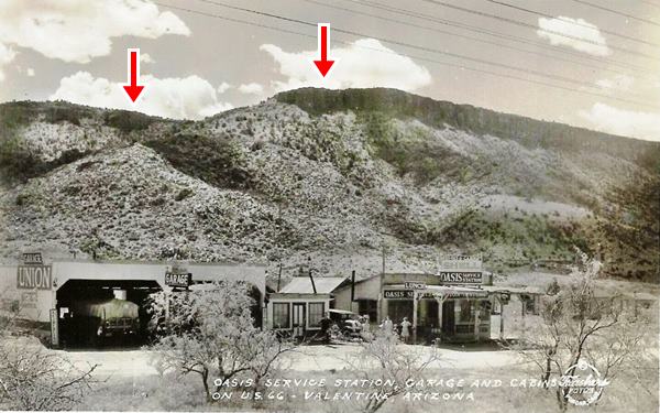
Below is the view from modern Route 66, the site lies on the south side of the tracks (Black arrow).
Site of the Oasis Store nowadays
The Store was relocated
When the highway was realigned on the western side of the railroad, Oasis Store moved, following its customers. It was built half a mile north of its original site.
Oasis Store in the mid 1930s
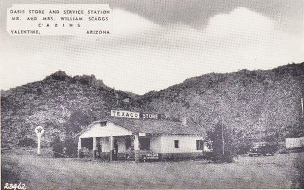
This is the street view nowadays. The buildings have long been razed. Now there is an animal sanctuary at this location.
Keepers of the Wild
This is a Non-profit sanctuary home for almost 150 wild animals, both indigenous or exotic. It provides a safe home for animals that are rescued, given up by their owners or handed over by animal welfare organizations. You will find tigers, lions and monkeys here. It isopen to the public 6 days a week.
Read more at the Keepers of the wild website.
Another "Then and Now" sequence at the old Valentine township.
A Photo looking north along Route 66 towards Valentine, Arizona in the 1940s. Oasis Store to the left.

There were more trees in the past, and the Keepers of the Wild sanctiary now occupies the place where the Oasis Store & Texaco once stood.
The same spot, looking north along Route 66, but the Texaco has gone
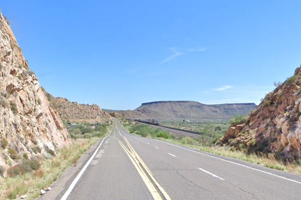
As you have seen, Valentine is not a town, instead, its is a dispersed village with several small groups of houses. The history of the town explains this layout.
There was a day school in neighboring Hackberry, established in 1894 by the Massachusetts Indian Asociation. Its purpose was to "civilize" the natives and instill Christian values in them. It was however an instrument of forced assimilation of the native people.
But the Hackberry School was too far from the Hualapai tribe and worse still, two students had died in Albuquerque after being mistakenly sent there by the authorities.
A new school was needed and that led to the creation of the Truxton Canyon Indian School.
Historic School in Valentine
Listed in the National Register of Historic Places

The Historic Valentine School Source. Click on image for street view
The Truxton Canyon Training school was created by President McKinley in 1898. He also created a reserve of 795 acres in George Aitken's ranch in "Truxton Canyon", next to the railroad, to provide easy access for teachers and supplies.
A siding was built there and named "Truxton".
The school itself opened in 1901 and the schoolhouse was built in 1903. It was a boarding house for boys and girls who lived there from September to May.
It was expanded in 1924 and again in 1927 and 1929. Its bricks were manufactured on site by the Hualapai students.
After closing in 1937, two of the three main buildings were demolished. The fields cultivated by students went fallow and the settlement withered. It is now owned by the Hualapai Indian Nation.
Over the 36 years of its existence, it educated around 750 students. Non-Indian children used another building, the Red Schoolhouse from 1924 to 1969.
Drive westwards; the highway follows the railroad and after 1.3 miles it begins to curve towards the west. The terrain becomes flatter to the south and the valley widens and there is one final wide curve and a cutting to accommodate the highway. This is where the following "Then-and-Now" sequence of Route 66 was taken. It was published in May 1934 and captioned "a recently completed section of U.S. Highway 66 near Hackberry constructed by state force".
The images show it as it was in 1934 and as it is today. The same rock outcrop is on the right side of US 66.

US 66 in Valentine in 1934. Source
Remains of a Motel
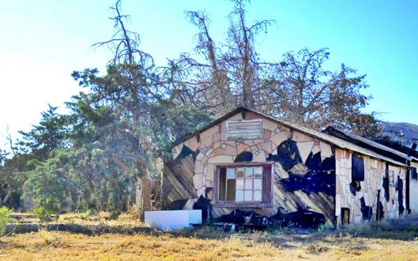
There are some buildings close to the road, and to your right is an old motel, vacant and unnamed.
The "L" shaped building looks like a motel, but it has no signs and is in need of repair. It is surrounded by pine trees and has a stone facade.
Old motel? is this the Chief's motel?
Opposite, on the south side of the highway, to your left is another attraction.

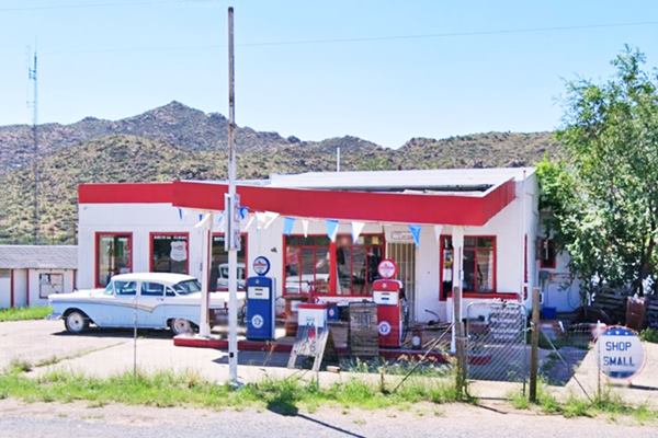
Pumps at Valentine Station
Valentine's Station
This Gift Shop opened in 2019 in a former gas station that has served Route 66 travelers since 1945.
Nicely restored, a great vintage styled logo and gas pumps. Worth stopping to take a look. (more at their website).
See How it looked before being restored, below is its current appearance:
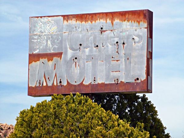
Chief's Motel Sign
Just ahead, to your right is the site of the former Chief's Motel. The two cabins, with four units are the remains of the motel (see them in this 1967 aerial photo).
All that remains standing is a rusting sign on which you can barely make out the words "Chief's MOTEL" with the faded effigy of an Indian Chief.
Bert's Country Dancing

Sign of Bert's Country Dancing, Valentine Arizona. Source. Click for street view
Next to the old motel, to your right is a sign that reads "Bert's Country Dancing" (see image, click on it for street view). There is a story behind it.
Elbert Riggs Denton (1915 - 1994) opened a small bar in Valentine in the 1970s. At that time some 200 people lived in the area. He'd open it once a week, on Saturdays, as a dance hall.
A sign on the wall stated "Banks don't sell beer, I don't make loans".
Customers dwindled after I-40 bypassed Valentine. After his death, the place opened occasionally, but it has been closed for many years. Its sign, and the small house that acted as bar and dance hall are still standing.
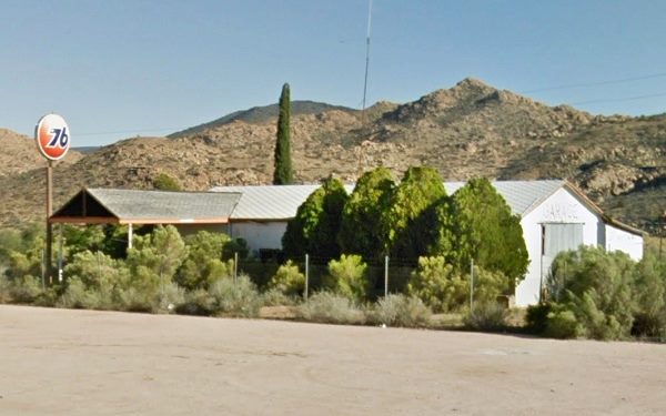
Drive west, and just ahead, to your left, on the south side of the highway is a fenced-off building with a orange Union 76 sign. It is the site of the former post office.
Valentine and its post office
Stop to see the abandoned Union 76 Service Station, the post office once stood next to it. This is its story.
Site of the last Valentine Post Office, it stood next to this Union 76 service station in Valentine AZ.
Valentine's first post office opened in 1901 at the site of the School, within the Indian Agency land. It was named "Truxton" after the station.
In 1910 it was renamed Valentine after the town.
Valentine's Day and Valentine Arizona

Cupid postmark from Valentine Arizona. Source
The post office used a postmark with Cupid's arrow, despite the fact that it was not named after Saint Valentine but after the Commissioner of Indian Affairs.
Valentine's post office used to recieve mail which was postmarked and remailed as a "A Valentine from Valentine, Arizona", but tragedy struck and ended this tradition.
It was relocated at the gas station in the 1970s. On August 15, 1990 Mrs. Jacqueline Ann Grigg, the postmistress was murdered by a teenager who robbed the post ($40 in cash and $800 in postal money orders) office and stole her car. He was later sentenced to life.
After the crime, the post office, which was next to the Union 76 service station operated by Mr. and Mrs. Grigg, was closed. Shortly after, the widower tore down the post office's building.
But the Kingman Post Office has the old Valentine AZ, postmark and uses it to stamp mail upon request. (its address is: 1901 Johnson Ave., Kingman).
Valentine Day letters
February 14th celebrates Saint Valentine's Day which honors the Christian imprisoned by the Romans for marrying soldiers. Prior to his execution, he cured the daughter of his jailer, a girl named Asterious and wrote a note to her, signining it "Your Valentine".
In the United States, almost 200 million cards are posted each year on Valentine's Day to loved ones.
The post office at Valentine was part of this ritual for decades.
Continue your Road Trip
This marks the end of this section of your Route 66 Road Trip, continue your journey by heading west to visit Hackberry.
Outdoors, National and State Parks
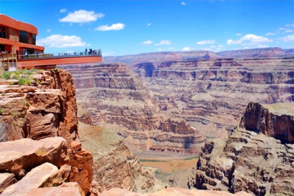
There are many outdoor places to enjoy nature nearby: starting from neighboring Peach Springs you can visit the Grand Canyon and go rafting along the Colorado River at Diamond Creek. You can take a tour and visit the Grand Canyon Skywalk and the Hualapai Mountain County Park.
The Grand Canyon Skywalk
73 mi. See the Map with Directions.
Opened in 2007 it is within the Hualapai Tribal land. It is a transparent horseshoe-shaped bridge that curves out and above the Grand Canyon 4,770 ft (1.450 m) above the Colorado River.
The best way to reach it is taking a tour as the roads are not in top conditions.
Read more at the Skywalk website.
Grand Canyon Skywalk
Some sponsored content
Lake Havasu City

Lake Havasu City, the lake and London Bridge. Source
The resort town of Lake Havasu City on Lake Havasu has beaches along the lake's scenic shoreline, an active nightlife and the original London bridge (you can take a Tour to visit it)
The adjacent state park is open 24 hs, and there is an entrance fee. It is located on a reservoir on the Colorado River. You can hike and enjoy the riverside.
Visit the scenic shoreline with beautiful beaches, nature trails, boat ramps, and many convenient campsites.
>> Book your Hotel in Lake Havasu City
Learn more about the outdoor sites in the Havasu State Park official website.
>> Book your Hotel in Peach Springs AZ


Credits
Banner image: Hackberry General Store, Hackberry, Arizona by Perla Eichenblat
Jack DeVere Rittenhouse, (1946). A Guide Book to Highway 66.


