
Route 66 at the Petrified Forest
Index to to our Holbrook pages
On this page you will find:
- Downtown Holbrook sights
- Eastern Holbrook's Vintage Route 66 motels & attractions
- Tours & Itineraries
- Parks and outdoors
On our Holbrook Page 1
Sights and Attractions in Holbrook, Arizona
Downtown and Histroric District of Holbrook
After visiting the western side of Holbrook with its classic motels, at the corner of Hopi Drive and Navajo Blvd, turn right, heading south.
On the second block, on the right-hand side of the road is the Rock Shop:
Rainbow Rock Shop

Dinosaurs at the Rock Shop in Holbrook
101 Navajo Blvd. Picking up petrified wood at the National Park is not allowed, so the petrified wood sold in local shops does not come from the park; it is obtained from private lands outside the park boundaries.
There is fancy polished wood and rough pieces of petrified wood, you can pick your choice. The fake dinosaur statues are awesome.
Keep on southwards, cross the tracks and on the first road, take a left. This is the Historical South Central Avenue District and the street is "Bucket of Blood St."
South Central Avenue Commercial Historic District
119 S. Central Ave.Holbrook, AZ.
Listed in the National Register of Historic Places
Buildings dating back to 1888 in the "Wild West" days of Holbrook it includes the Bucket of Blood Saloon.
The South Central Avenue runs on the south side of the tracks in south Holbrook. It was the downtown area of the city in the 1880s.
The buildings were built after the fire of June 26, 1888 that destroyed most of the downtown area.
To avoid fires, they were erected in adobe, bricks and stone. Four commercial buildings make up the historic district, They are, from west to east, the H. H. Scorse Mercantile, the Pioneer Saloon, the Robinson & Co. Drug Store and the Bucket of Blood Saloon.
After the 1923 flood the business district moved to the north side of the tracks, and most buildings on the south side were abandoned.

Wackiest Street Name
According to USA Today, South Central Avenue which is also known as "Bucket of Blood Street", was ranked 6th in "wackiest street names" in the USA.
Bucket of Blood Saloon
119 S.Ctral. Ave. See its St. view.
Part of a site listed in the National Register of Historic Places
Saloons were a key element in the social life during the Old Wild West days. Ranch workers interacted, drank heavily, played cards and womanized there. Alcohol and gun-toting men led to frequent shootings too.
The place was originally named "Cottage Saloon", and was built in 1888 by Byron Terril who sold it the following year to Charles O. Brown.
After a double murder that took place there in 1891, it was informally known as "Bucket of Blood". The county prohibition in 1913 and the statewide prohibition on December 31, 1914 killed the business.
Head back along Navajo Blvd. and retrace your steps to your starting point and then go north, along Navajo Blvd., after one block, cross to the eastern side of the road and visit the Courthouse.
Historic Navajo County Courthouse

Navajo County Historic
Courthouse and Museum.
Source
100 E Arizona St.Holbrook, AZ.
Listed in the National Register of Historic Places
Historic County Courthouse built in 1898 in a Richardsonian Romanesque style. It now houses the Chamber of Commerce office and the Old West Museum
Navajo County Historical Society Old West Museum
100 E Arizona St.Holbrook, AZ.
The museum has exhibits, collections, and artifacts from Holbrook's past.
Daily 8:00 AM to 5 PM. (928) 524-6558. Free Admission. holbrookazmuseum.org
Eastern Holbrook's Vintage Route 66 motels
Now we will visit some of the old diners and vintage Motels along the old Route 66 east of the downtown area. Start your tour on the estern (north) side of the downtown district.
Downtown motels
Former Moenkopi Motel
464 Navajo Blvd. To your right. It was located in "Happy Holbrook" according to its matchbook. The word is Navajo and means "Running Water". Now it has become apartments for rent.
A 1960s postcard of the Moenkopi Motel, Holbrook, AZ. Route 66

The modern neon sign is more attractive than the original one. The canopy by the office is the same, but a second floor was added to the office.
How the Moenkopi Motel looks today

Two blocks ahead was a classic motel, now it has been razed. Only the pool and its building, on the southern side have survived.
The Motel Tonto (Gone)
602 Navajo Rd. Holbrook, AZ. The Motel Tonto proclaimed its features on the back of the postcard shown below: "MOTEL TONTO 602 Navajo Blvd., Holbrook, Arizona 86025 Phone 524-6263 Interstate 40, U. S. 66 - 2 blocks from center of town - 30 Units - Heated Pool - Room Phones - TV - Refrigeration - Tub-Shower Combination - Large Family Units - Free Ice - Pets Welcome."
By the way, do you know what "Tonto" means in Spanish? Well, it means "dumb", "silly", "fool", "idiot". The name was made famous among English speakers by the fictional character from the Lone Ranger who was Comanche, named Tonto. This name was probably inspired by the name of Tonto Basin in southern Arizona which in turn was named after Tonto Creek, which was named so by Woolsey in 1864 after his Yuma employee Tonto Jack.
A 1960s postcard of Motel Tonto in Holbrook, AZ. Route 66
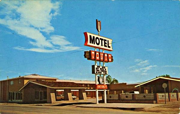
It later was a Budget Inn, and more recently until 2017, a Knights Inn. See its 2015 St. view while it was still standing, and the same spot in 2022 with the motel razed.
Ahead is another motel.
Holbrook Motel, now the Americas Best Value Inn Holbrook
720 Navajo Blvd. The Holbrook Motel, shown in the postcard below (from the 1950s), was described as "THE HOLBROOK MOTEL U. S. 66 East Holbrook, Arizona 62 Modern units - T. V. - ceramic tiled showers, wall to wall carpeting, refrigerated air conditioning, individually controlled wall heaters. Away from the railroad noise and focal point for the Painted Desert, Petrified Forest, Grand Canyon and the Indian Country. Phone JA 4-6216. Restaurant - Excellent Food.".
It is still open, but its name has changed to Americas Best Value Inn Holbrook. Some of the original building's features are recognizable like the crested brickwork on the roof.
Then: The Holbrook Motel in the 1950s, in Holbrook, AZ. Route 66

Now: Americas Best Value Inn Holbrook, Holbrook AZ on Route 66

Pow Wow
On the corner is a classic trading post and rock shop, the Pow Wow, now closed. It has a great neon sign decorated as a horned Navajo Kachina doll. (St. view).
Across the street, is an iconic
The Corral
865 Navajo Blvd. A Bar; drinks, jukebox and pool tables. No food. A nostalgic old saloon to quench your thirst and get the local feel.
It's been on Route 66 since the 1940s (Corral Cocktails and Cafe). Don't miss the murals on its southern wall.

Vintage postcard Corral.
Source

The Corral nowadays. Click for St view
El Rancho Motel & Restaurant
867 Navajo Blvd. Next to the Corral, this brick building has changed over time, but the main structre at the corner with three windows is the same. It has a nice neon sign too.
The El Rancho motel in the early 1960s

Now: El Rancho as it looks today.

Continue north and take the underpass beneath I-40. The old Route 66 continues northwards, with more attractions.
66 Motel

1940s postcard of the 66 motel. Source
2105 Navajo Blvd. To your left, on the western side of the highway is a classic Route 66 motel. As you can see in the image, it has been around since the 1940s.
It later changed its neon sign, which survives until this day.
The postcard portrayed it as having "Twenty-six modern, insulated units, each with private shower, adjoining car shelters, Simmons beds. Brand new. Sound proof. Cafe on grounds. No railroad noise."
The Hilltop Café is next to it.
66 Motel nowadays.

It is still open, operating as a motel.
> > You can Book a Room in 66 Motel
66 Motel in a 1960s postcard.

Tepee Curios

Tepee Curios postcard 1950s
Source
2106 Navajo Blvd. Facing the 66 Motel, is an iconic Trading Post, souvenir shop and bar. Air conditioned, it sold sodas, beer and Navajo handicrafts.
The image shows it as it was in the 1950s (click on it to enlarge).
The building is stil there, repurposed into Nichols Sportsman, Guns & Gunsmith (St. view). It has an interesting sign, with an arrow.
Whiting Service Station
2218 Navajo Blvd. To your right is an abandoned former Whiting Bros. gas station followed by another classic motel of the same company, the former Whiting Bros. Motel (North Holbrook).
The Whiting Bros. Gas station in ruins

Sahara Motel, former Whiting Bros. Motel North Holbrook
2402 Navajo Blvd. To your right. This is the second Witney Brothers Motel in Holbrook the other is in Western Holbrook (Read more: West Holbrook Whiting Motel).
The motel was built in the 1960s with a modern geometric design typical of that period. The building hasn't changed. Only the Neon sign has adapted and shifted its position.
The Whiting Bros. Motel on the north side of Holbrook in a 1960s postcard.

Currently the motel is the Sahara Inn.

Whiting Bros. and Route 66
> > Read more: Visit our Whiting Bros. and Route 66 webpage.
Learn all about the motels and gas stations of Whiting Bros along US 66 in New Mexico and Arizona.
After the motel is an abandoned gas station (to your right). And this ends your tour of Northern Holbrook. Head west to visit The Western side of Holbrook, described in our page 1 of Holbrook.
Tours & Itineraries plus outdoor Fun
Petrified Forest National Park
The nearby Petrified Forest National Park is the Only National Park on Route 66and is a great attraction; it also preserves some sections of the old Route 66 alignment. Take a day trip and visit both National Park and old US 66; you can also search for tiny chunks of a metorite that fell near Holbrook in 1912.
Trivia: Holbrook's Meteor
The Meteor Fall of 1912
At 6:30 in the evening on July 19, 1912, a booming sound followed by successive explosions was heard over Holbrook. A meteor exploded in mid air, about 1 or 2 miles high, 6 miles to the east of the town, and fragments fell over an oval-shaped area abouth 1.5 mi. wide and 1 mi. long.
The neighbors went to the impact site, the section house at Aztec Rail Yard, and recovered thousands of fragments of the meteor. The largest weighed 14.5 lbs (6.6 kg) and can be seen at the Bateman Physical Sciences Center at Arizona State University in Tempe, other pieces were the size of peas. The metor must have weighed 421 lbs. (200 kg). The Foote Mineral Company of Philadelphia purchased the remains and 16,000 pieces have been recovered.
It was an L6 chondrite meteor, which has "chondrules" of metal-sulphide, an interior with silicate mineral and spots of nickel-iron alloys and iron-sulphide compounds.
To reach the place where the meteor fell, see Map, it is 12 miles from the town by road.
The Alignment of Old Route 66 near Holbrook
Driving eastwards from Holbrook
Head east along the freeway and at Exit 294 stop to visit a former Stuckey's from the 1960s.
Sun Valley Stuckey's
7699 Sun Valley Rd, At exit 294. On the southwestern side of the exit is the former Sun Valley Station. Located only 8 miles east of Holbrook, it once had a Texaco gas station and a Stuckey's convenience store chain. Its slogan was "Relax, refresh, refuel!".
The building was "8 miles east of Holbrook, Ariz. Hwy 66 & Interstate 40", and it is still standing, with its typical "A" shaped roof. Now it is a knifeshop.

Vintage photo of Stuckey's
Source

Nowadays source, Knife City Outlet.
On the north side of the Exit is the old Sun Valley Motel (now vacant, and until recently the Root 66 Sun Valley RV Park) pictured below in a "Then and Now" sequence:


Ahead is the Petrified Forest National Park
Holbrook is the western tip of the US 66 segment that links Sanders with Holbrook, which is in our Lupton to Winslow webpage
There is a rough back country dirt surfaced road that was the original US 66 alingment from Navajo Trading post into the Petrified Forest National Park, you can see it in this Map from Navajo T. P. to Petrified Forest NP.
This marks the end of the eastern approach into the National Park along old Route 66.
Route 66 in the Petrified Forest National Park
For those who'd rather drive along the freeway, go along I-40 to exit 311, and enter the National Park (you will have to pay a fee to do so).
Once in the park you can visit the remains of two classic Route 66 Trading posts on the original 1926 to 1950s alignment. Below we describe this short tour.
The many Painted Desert Trading Posts Along Old Route 66
There were several Trading Posts with a very similar name on Route 66 east of Holbrook in the Petrified Forest area and all has very similar names. We will describe them in this section.
This is the map with directions to the easternmost post. To visit it, take I-40 westwards from Holbrook and head north from Exit 311. Enter Petrified Forest National Park, pay the park fee and check at the Visitor Center for additional information, road conditions and permission to drive along it.
Route 66 in Petrified Forest National Park
Half a mile beyond the Entry Station to the Park, to your right, heading east is the alignment of the 1926 to 1958 Route 66. Below is a photo of the junction of Route 66 with Petrified Forest Rd.. Below is a view looking east from the junction.

Now the alignment ends here, at the junction,but the original Route 66 continued straight on, to your left, with a NE to SW course, this original alignment was later erased. but you can see it in our custom map (blue line)
Just west of this junction was a tourist trap that cashed in to the Petrified Forest and Painted Desert, the "Tower":
Painted Desert Tower (razed)
Located west of the Park's visitor center (location map). Julia Miller owned a 160 acre homestead in the middle of the park and she ceded it to her son, Charley Jacobs (who also owned the Indian Village in Chambers.) He was concerned about the realignment in Chambers bypassing his store, so in 1953 he built the Painted Desert Tower on this property as he believed that the new alignment of Route 66 would pass close by his new establishment. However, the National Park Service bought him out in 1958 and razed the spot. Below is a photograph of this tower. I took this picture in 2016 at the Route 66 marker further east.

Turn right and head east along Route 66. Ahead, after 0.6 miles, is the site of another "Park":
Painted Desert Park - The Lion Farm (Gone)
Set on the north side (to your left) of the highway, see the map showing where it was, it was the brainchild of Harry E. "Indian" Miller, who also owned the Zoo and Trading Post & gas station further west along US 66 in Two Guns AZ. Miller had partnered with his nephews Paul and William Jacobs in 1927 to build a farm by the Painted Desert. He owned the land, and it was not located within the original boundaries of the Petrified Forest National Monument. At that time the railroad marked its northern boundary. In 1932 it was extended north to include the addition of Painted Desert and that brought the "Lion Farm" into the park. By that time Miller had moved to the Cave of the Seven Devils close to the NM-AZ state line and left his sister Julia Miller, mother of Paul and William, in charge.

It had a tower overlooking the Painted Desert, cabins, souvenir shop, gas station. Its signs read "Mountain Lion Farm" and "Painted Desert Park Zoo." The zoo had eagles, fox, mountain lions, coyote, bobcat, and later pigs, gila monsters and badgers. The National Monument authorities wanted to buy them out, the zoo was an "eyesore" that had to go. By 1950 Charley Jacobs -Julia's other son- delegated management of the park to Albert Tietjen and refused to sell it. The National Monument put pressure on the Arizona Highway Dept. to realign Route 66 bypassing the Lion Farm in the around 1954 and isolating it from potential visitors. Finally Jacobs sold out his bypassed and vacant Park in April 1962 and the monument was designated as a national park in December 1962. (1)
Painted Desert Trading Post
This is the next trading post, further east (see this map with directions).

Dead Wash bridge. Source
Just ahead, take a left along the dirt road eastwards, drive east for 6.3 miles along Pinta Rd. Cross the bridge over Dead Wash (named so because a prospector named Lewis was found dead there by his neighbor, Jackson, in 1897). Just ahead is the Post.
The Painted Desert Trading post offered rugs, curios, jewelry, and also sandwiches and cold beverages. It had two gas pumps in the front (no canopy), and a simple white building with a flat top and the three windows that faced forward with a single entry door.
It was built by Dotch Windsor in 1942, who ran it with his first wife Joy Nevin until they divorced in 1956. It was the dawn of the Interstate period and Dotch closed the post.
Painted Desert Trading Post in the 1930s. Petrified Forest National Park near Holbrook, AZ. Route 66

Holbrook, AZ. Source
Over the course of eighty years the passing of time has caused, ruin and decay. As you can see below it was in ruins. The dorway was empty and the windows gone. The words Desert Trading Post were faded but could still be made out on the front of the former store:
Painted Desert Trading Post, Petrified Forest National Park near Holbrook, AZ. Route 66

Holbrook, AZ. Source
Fortunately it was recently restored and has recovered its former grandeur. Learn more about the rescue project:

Turn around and head back to your starting point in the National Park. And visit another Route 66 spot in Petrified Forest National Park (Map with directions.) Turn right along Petrified Forest Rd. ahead is another (there were many!) Painted Desert establishment, the Painted Desert Inn.
Painted Desert Inn
National Historic Landmark
The first inn, Stone Tree House, was made of petrified wood and built in the 1920s by Herbert D. Lore. It was renovated in the 1930s by the Civilian Conservation Corps as part of the Painted Desert Addition, in an adobe - pueblo style. After WW II it was reopened under the Fred Harvey Company's management and renewed by Mary Elizabeth Jane Colter in 1947. The museum and inn moved to a new complex in 1963 due to structural issues with the original building, and it was slated for demolition in 1975. A public campaign saved it, it was named a National Historic Landmark in 1987 and is open for all visitors.

Stone Tree House, 1930s postcard. Source

Painted Desert Inn nowadays. A. Whittall
Drive along Petrified Forest Road, stop at the viewing spots, the sights are amazing. Route 66 reappears ahead, where it crossed the Petrified Forest Road again. There is a small marker and a must-see monument commemorating Route 66 within the park.
Route 66 Marker
Commemorating Route 66 and Petrified Forest National Park

See where it is, in this map, the point marks where Route 66, coming from the trading post in the east, crosses Petrified Forest Rd. and heads west into the desert. The roadbed is not visible at ground level, but can be seen in satellite images. A line of telephone poles marks the alignment of the original Route 66 (you can see them in the photograph).
The marker has a concrete bench with a Route 66 shield, and a chrome vintage car bumper set in it. It belonged to a 1957 Cadillac Fleetwood. It is a front Dagmar Bumper (the word Dagmar came from the splendid figure -and bosom- of Virginia Ruth Egnor's 1950s TV character "Dagmar") pictured below.
Next to it are the remains of a rusty 1932 Studebaker and a sign with information titled "Highway of Dreams", pictured further up.

Here you can retrace your steps back to I-40 to continue your itinerary along Route 66, or continue straight and visit the National Park. You can return to this point later or head west to Holbrook from the South side of the park (South side Petrified Forest to Holbrook along US 180.)
>> Book your Hotel in Holbrook
A Short tour in the National Park
The views on this side of the park are amazing, the Painted Desert deserves its name.

Route 66 heading West from the Park
Return to Exit 311 on I-40 and head west along the freeway. The original US 66 alignment coming from the "Route 66 Marker" in the Park is now covered with bushes, it crosses the freeway 2 miles west of Exit 311 (see map).
The freeway cuts the old alignment at this point; the original Route 66 continues on the south side of I-40. This alignment can be driven. To reach it if you want to drive along it, leave I-40 at Exit 303.
This is map of the driveable US 66 alignment from Petrified Forest to Big Lithodendron Wash, it is a 8.1-mile-long segment.
At the exit, turn left, eastbound to the "other" Painted Desert Trading post. It is a 3.8-mile drive.
Painted Desert Point Trading Post

1940s postcard of the
Painted Desert Point Trading Post
nps.gov
It was located 21 miles east of Holbrook. You can reach it (map with directions) from Exit 303 on I-40 head to the south side and drive east for 3.8 mi. It is on the north side of the Old Route 66.
Built in 1946, it sold Shell gasoline. Only the foundations of the rectangular building and the concrete base of the gas pumps remain. At one time it was rumored that it had illegal slot machines. It was run by Harry Charles Osborne, who in 1952, aged 78 was forced to kill his deranged son at the trading post.
Head back to Exit 310, and head one-half mile east along US 66 right to head west along old US 66 to reach the bridge:
Big Lithodendron Wash Bridge
Route 66Holbrook, AZ.
Listed in the National Register of Historic Places
A wooden truss bridge built in the 1932 on US Highway 66
This wooden bridge is 243 ft. long and 23 ft. wide, its longest span is 18.7 ft. long. It crosses the Big Lithodendron Wash, also known as Carrizo or Little Carrizo Wash -Carrizo is Spanish for "rush".
The word Lithodendron combines the Greek words "Lithos" (stone) and "Dendros" (tree), "stone tree" after the neighboring Petrified Forest National Park.
The wash has several branches that Route 66 had to cross. Two bridges were erected in this spot, and only one survives. It is a timber tressle bridge built 1932 and rehabilitated in 1986 it can still be driven across.
It is a "tressle" bridge because the short timber spans are supported by a rigid frame or "tressle"

Petrified Forest National Park
It is the only National Park in the U.S. to include and protect a section of Route 66. Its badlands of multi-colored stones, with bands of red, violet, green, ochre, and white sediments from the Triassic period, 200 million years ago, are worth seeing. And then is the petrified wood, the fossils and historical sites...
What to see and do?

Agate bridge, 110 ft (34 m long) fossil trunk with a concrete beam supporting it since 1917.
A. Whittall.
Short 2 to 3 hour visit
At least Walk the Painted Desert Rim Trail to Kachina Point, Drive Blue Mesa Road and Stop at Rainbow Forest Museum to see the stone tree trunks strewn on the ground.
- Stop at the Painted Desert Visitor Center
- Drive the 28 miles of road through the park: to the south, visit the Rainbow Forest Museum and watch the park film; walk Giant Logs and Crystal Forest trails; drive the Blue Mesa Road. To the north: Visit the Painted Desert Visitor Center and watch the park film
- Drive the circuit and stop at the overlooks in the Painted Desert, include a stop at the Painted Desert Inn National Historic Landmark.
View of some petrified trees at Petrified Forest National Park

Half a Day visit

Ruins of the Puerco Pueblo site. Don't miss the rock art here!
A. Whittall.
Add the following stops:
- Drive through the entire park.
- Stop at Painted Desert Inn Museum (in the Historic Landmark).
- Walk the trails at Painted Desert Rim and Crystal Forest.
- Stop at the Route 66, Newspaper Rock, Agate Bridge, and Jasper Forest overlooks.
- Visit Puerco Pueblo, walk the Puerco Pueblo Trail.
- Hike the Blue Mesa and ⁄or Agate House Trails.
- Walk the Giant Logs Trail (pick up a trail guide at Rainbow Forest Museum)
One or more days
Do the above and add:
- Choose an Off the Beaten Path hike into the Wilderness Area
There is no overnight lodging in the park, camping in the park is limited to backpacking in the wilderness area and permits are required.

The Petrified Trees
200 million years ago, during the Late Triassic Epoch, this area was a lush rainforest with ferns and coniferous trees 10 ft. in diameter and 180 ft. tall. As they died or fell, they were buried by sediments or covered with volcanic ash (known as the Chinle Formation) that preserved them before they decomposed. Groundwater later dissolved silica in the volcanic ash and saturated the logs, and crystallized, replacing what was once living tissue with quartz. This preserves the life-like appearance of the wood.
Iron oxides give the petrified wood its red, orange, and ochre hues.
60 million years ago, the uplift of the Colorado Plateau led to the erosion of the younger rock that overlay the Chinle Formation, and this uncovered the logs and fossil plants.
The park is one of the few in the world to have flora from the Late Triassic: cycads, ferns, ginkgoes, lycopods, and more.
More details: Official Petrified Forest NP Website.
Painted Desert Inn
Petrified Forest N. P.Holbrook, AZ.
Listed in the National Register of Historic Places
A classic National Park lodge built in 1920 and restored to its original 1949 appearance. Now a museum.
Built in 1920 by Herbert David Lore as a lodge, it was acquired by the National Park Service in 1935. It was originaly built in petrified wood, but it was soon renovated in a Pueblo Revival Style after it was purchased.
It has ponderosa Pine logs protruding from the adobe and stone walls, earth-toned stucco, and flat roofs. It was renovated by Mary Jane Colter in 1947 and closed in 1963 when a new visitor center replaced it. It was saved from demolition in 1976 and was designated a National Historic Landmark in 1987.
It was completely restored to the way it looked back in 1949 and reopened in 2006. It is no longer an inn, but a museum, don't miss the restored murals by Hopi artist Fred Kabotie or the mountain lion petroglyph on exhibition there.
Go to Western Holbrook
In the Previous Page you'll find Western Holbrook's attractions and an overview of the city:
Some tours and sightseeing
Sponsored content
Lake Havasu City

Lake Havasu City, the lake and the London Bridge. Source
The resort town of Lake Havasu City on Lake Havasu has beaches along the lake's scenic shoreline, an active nightlife and the original London bridge (you can take a Tour to visit it)
The adjacent state park is open 24 hs, and there is an entrance fee. It is located on a reservoir on the Colorado River. You can hike and enjoy the riverside.
Visit the scenic shoreline with beautiful beaches, nature trails, boat ramps, and many convenient campsites.
>> Book your Hotel in Lake Havasu City
Learn more about the outdoor sites in the Havasu State Park official website.
>> Book your Hotel in Holbrook AZ
Source
Banner image: Hackberry General Store, Hackberry, Arizona by Perla Eichenblat
Jack DeVere Rittenhouse, (1946). A Guide Book to Highway 66