Route 66 in Manuelito NM
Index to this page
About Manuelito, New Mexico
Facts, Trivia and useful information
Elevation 6,260 ft (1.909 m), population 2020 n⁄a.
Time zone: Mountain (MST): UTC minus 7 hours. Summer (DST) MDT (UTC-6).
Manuelito is a small village in McKinley county, 17 miles west of Gallup and only 9 miles from the Arizona State Line.
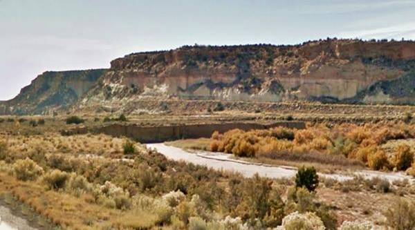
Rio Puerco of the West and beyond it, the sandstone cliffs and Route 66, in Manuelito, NM. Route 66
History
This part of New Mexico bordering Arizona has been populated for the last ten thousand years. More recently the Anasazi, ancestors of the Pueblo Indians lived in the area (until ca. 1300 AD) then they moved south and east leaving the territory to the Navajo People.
The expedition led by Spanish coquistador Francisco Vásquez de Coronado reached the nearby Zuni Pueblo in 1540 and explored New Mexico (and Arizona, reaching the Grand Canyon) and the Great Plains. The Spaniards returned in 1597 to occupy the Rio Grande River area, and subdued the Pueblo farmers. But they did not dare enter the land of the fierce Navajo people.
Mexico became independent from Spain in 1821 and took over the territory of New Mexico but ceded it to the US after losing the Mexican American War of 1846-48. During this period, the Navajo raided the villages to the south and east.
The U.S. Army established Fort Defiance in what is now Arizona, north of Manuelito in 1851, in the heart of the Navajo territory. Attacked several times, it was abandoned during the American Civil War (1861). The army centered its campaign against the Navajo in "Old Fort Wingate" close to what is now Grants NM.
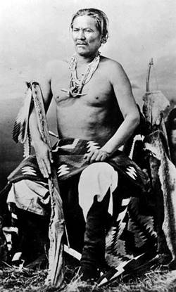
A portrait of Manuelito, Source
The Navajo were defeated by an attrition war and the starving natives were forced to march to a reservation near Fort Sumner NM ("The Long Walk"). Their calamitous situation led to a public outcry. The Army commander, Brig. Gen. James Carleton was displaced and the Navajo people allowed to return to their homeland, which became the Navajo Nation Reservation in AZ and NM (1870).
Fort Wingate was moved closer to the Reservation (to Wingate east of Manuelito) and Fort Defiance was reestablished. Nowadays Fort Defiance is a village in the Navajo Nation in Arizona.
The military road that linked both forts passed through Gallu NM. This route was surveyed by the The Atlantic & Pacific Railroad (later the Atchison Topeka and Santa Fe RR) for their railway across the Continental Divide to the Pacific.
The name: Manuelito
The raliway station was named after the a Navajo Chief, Manuelito.
Chief Manuelito (1818 - 1893) was one of the most important Navajo leaders, and he was a brilliant warrior.
He had several Diné (Navajo) names as was the custom among them: Ashkii Diyinii (Holy Boy), Dahaana Baadaané (Son in Law of Late Texan), Nabááh Jilt'aa (War Chief) among others. The New Mexicans called him "Manuelito" which is the diminutive form of "Manuel", a Spanish name and it literally means "Little Manuel".
Manuel derives from the Hebrew name Immanu'el "The God among us".
He was a member of the Bit'aa'nii clan and was born in SE Utah. He resisted the advances of the U.S. Army in the 1850s and 60s, but ended up with his people in the Bosque Redondo camp near Ft. Sumner.
He signed the 1868 treaty that ended their confinment in Bosque Redondo and allowed them to return to their homeland, in a Navajo Reservation.
The first European settlement here was on the south side of the Western Rio Puerco River: "Cooks Ranch" which was a stage stop on the Star Rail route through Holbrook Arizona to Ft. Whipple. The railroad reached Gallup in 1882 and pushed westwards reaching Manuelito shortly after. The railway's station was named Ferry Station, but by 1895 it was named Manuelito.
The station replaced Defiance as the supply point for Fort Defiance, and Manuelito Canyon that has a NW course from the station was the route that linked it to Fort Defiance.
The Navajo name for the village was "ugly house" or "abandoned house". It refers to a nearby Anasazi ruin.
In 1926 Route 66 was aligned through the area following NM state highway 6 which in turn ran next to the railway. Manuelito appeared in the Rand McNally 1927 map of Route 66, as being 9 miles west of Defiance and 6 miles east of Lupton, Arizona on an unpaved but improved highway.
Route 66 was later replaced by I-40 in the 1960s, bypassing Manuelito on the south side of the Western Rio Puerco River.

Where to Stay: Find your Hotel near Manuelito
There are plenty of accommodation options on Route 66 in neighboring Gallup so you won't have difficulty to book your room in that city:
> > Book your Hotel in Gallup
More Lodging Near Manuelito along Route 66
Below you will find a list of some of the towns along Route 66 in New Mexico. Click on any of the links to find your hotel, motel or accommodation in these towns (listed from east to west):
On Route 66's Main alignment
The Santa Fe Route 66 segment
Eastwards
Westwards
>> There are RV campgrounds nearby in neighboring Gallup
The weather in Manuelito
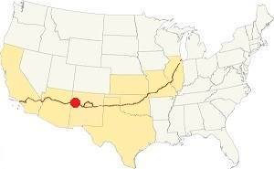
Location of Manuelito on Route 66
The dry climate and high elevation of Manuelito make its winters cold and summers hot. Nevertheless, the dry air and high altitude provide relief in summer: nights are cool, but in winter it makes the nights even colder. Day-to-night temperature swings are quite ample throughout the year.
During winter the average high temperature is about 45°F (7°C) with an average low "below freezing": 11°F (-12°C). The average summer high is 89°F (32°C) and the low is a cool 51°F (10.6°C).
Rain is scarce: around 11.5 in (292 mm) per year. The rainy season is during the "Summer Monsoon" between Jul. and Nov. (6.8 in, 173 mm); there are some 70 days with precipitation each year.
Snow is quite heavy and averages around 30.4 inches (77.2 cm) per year which can fall at any time between Oct. and May, but usually between November and March.
Tornado risk
There is virtually no tornado risk in Manuelito: McKinley County has no Tornado watches. The area west of this point has no tornado events at all.
Tornado Risk: read more about Tornado Risk along Route66.
Map U.S. 66 in Manuelito New Mexico
Maps of Route 66
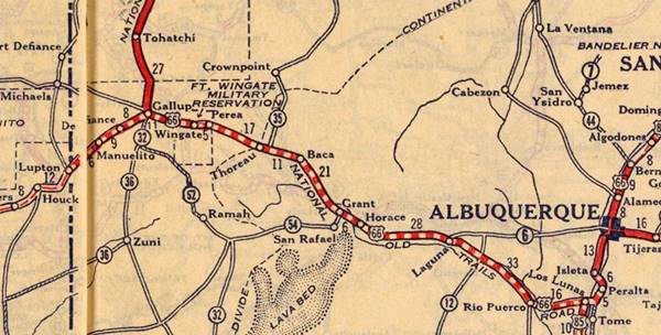
Driving west from Defiance, the highway ran on the south frontage road of the freeway but at Rocky Point, it was overlaid by the freeway all the way to Exit 8, where it crosses to the north side of I-40 and crosses the railroad using an overpass to follow NM-118 westwards. This gap is marked with a yellow line.
To Manuelito and State Line
The highway now follows NM-118 for 3 miles, all the way to Manuelito on the north side of the Puerco River, running parallel to the railroad tracks. The freeway runs beyond the river, along its south side.
State Line
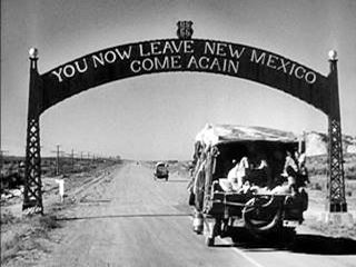
The Gateway Arch at New Mexico - Arizona state line on Route 66. From The Grapes of Wrath (1940)
Ahead, 4.3 miles west of Manuelito, at the state line, the freeway crosses the railroad and interrupts the original US66 alignment into Arizona. The modern N. Frontage Rd. curves north and follows the freeway into Lupton, Arizona. However the original alignment of Route 66 continued straight and ended up on the South Frontage Road after crossing the State Line. This map marks the alignment with a Red line. A short section along the access ramp at 359 in AZ and the EB lanes of I-40 are aligned along the original roadbed.
This was the location of the classic Academy Award winning movie "The Grapes of Wrath" (1940), based on the Pulitzer Prize-winning novel written in 1939 by Nobel Prize author John Steinbeck (1902 -1968).
>> Learn more on our Grapes of Wrath
Route 66 Alignment near Manuelito
With maps and full information of the old roadway.
- Lupton to Winslow (next)
- Albuquerque to Lupton (Manuelito's)
- Santa Rosa to Albuquerque (previous)
Manuelito: its Attractions
Landmarks, Route 66 sights:A small Village among Sandstone Buttes
Historic Context
Jack Rittenhouse in his 1946 Guidebook to Highway 66 mentions why the village got its name and added:
MANUELITO... This small community of homes, church, and school lies of US 66 (L[eft])... No Tourist facilities.Rittenhouse (1946)
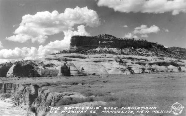
After crossing the tracks at the overpass, the highway curves with a NE-SW course and runs parallel to the river. This drive along Route 66 into Manuelito is a lovely experience. The road was built right beside the sheer sandstone cliffs that close in on the Rio Puerco of the West River. the highway runs parallel to the railroad, on the north side of the river. After 0.8 miles you reach an old Trading Post.
Dean Kirk's Trading Post
Dean Kirk was the stepson of Mike Kirk, owner of the Trading Post in Manuelito, a couple of miles west. Dean opened his store in the late 1940s after his father's death and sold jewelry rather than general merchandise. The store remaind open until the late 1950s. It was housed in the east wing of the Manuelito Mission, an adobe Pueblo-style building. It is on the north side of the road (right) and you can see it in this aerial photo taken in 1952.
Village of Manuelito
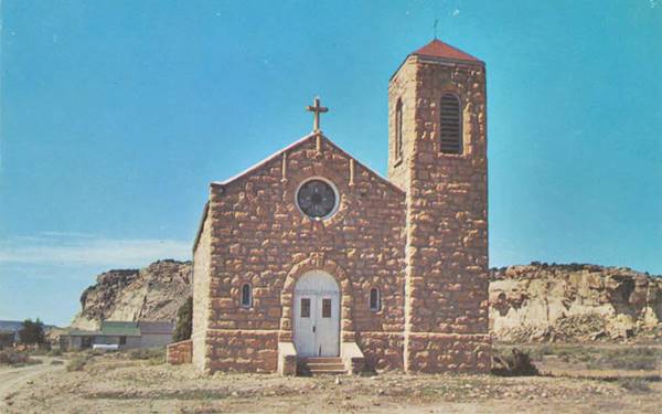
The highway continues skirting the mesa's red banded cliffs for another 2.2 miles until it reaches the village of Manuelito. Here was the site of the church mentioned by Rittenhouse in 1946, depicted in the postcard below, which has been torn down; this map marks where it stood. The postcard from the 1950s reads "Indian Mission Church on U.S. Highway 66 in Manuelito, New Mexico..."
Manuelito Trading Post ❌
The first trading post here was established in 1881 with a posts office, when the railroad arrived, it was ran by a Mr. Brown, shortly after, Steven Aldrich and James Bennett acquired. Bennett sold his stake to Elias Clark in 1883 and opened more trading posts. Clark left the partnership and a Navajo leader, Chee Dodge joined it. All these businesses were linked to Manuelito railway station and the military road -a wagon trail- that joined Ft. Defiance with Manuelito and, further south, after crossing the Rio Puerco, with Zuni.
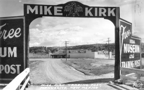
Aldrich joined as a partner and ran the Manuelito post until his death in 1921. Mike Kirk bought his interests and ran if for another twenty years when he too passed away. A.P. Gonzalez ran it after WWII, and then John Wall in the 1950s. The freeway bypassed the village and the store closed by 1963.
It was located on the south side of the highway with its original entrance facing the railroad. When US 66 was aligned on the north side, a driveway was built to give access to the highway. It was in ruins in the mid 2000s.
Historic Route 66 from from Manuelito to the Arizona State Line
Old Route 66Manuelito, NM.
National Historic Landmark
The road was built as part of the National Old Trails Highway which became New Mexico state highway 6 in 1914. In 1926 it was incorporated into the alignment of U.S. Highway 66.
The road west of Manuelito follows the Western Rio Puerco River's Valley, along the north side of the River. It is a valley which narrows at times and is enclosed by sheer sandstone cliffs that rise from the valley floor.
Juniper and pinyon trees grow on the mesas and the railroad runs next to the highway. This was a difficult stretch due to the unstable terrain at the roadcuts which washed away or were covered by rockslides.
The road was paved in 1930 and has great vistas of the "Devil's cliff". New steel mesh fencing protects the road from rockslides.
Ace in the Hole Movie (1951) and Manuelito

Ace in the Hole movie poster, 1951. Source. Click to enlarge
The film: Ace in the Hole
Ace in the Hole was a Paramount Pictures movie released in June 1951. It was directed by Billy Wilder and its cast included Kirk Douglas, Jan Sterling, Bob Arthur, Porter Hall, and Frank Cady.
Plot: Leo Minosa (Richard Benedict) is trapped in a collapsed cliff dwelling next to his trading post and a cynical reporter, CharlesTatum -played by Kirk Douglas, sees the opportunity to recover his big job in the newspaper business by getting exclusive access to the victim and broadcasting it nationwide. He deliberately delays the rescue operation with the help of the local Sheriff and tourists flock to see the place. A few days later Leo contracts pneumonia and dies. Leo's wife (Jan Sterling) stabs Tatum after he tries to strangle her. Tatum is disgraced again when other reporters send the story off before he does, and dies from his wounds.
Location of the Movie
Lookout Point Trading Post ❌

Cliff Dwelling Trading Posts 1950s brochure, Route 66. Source
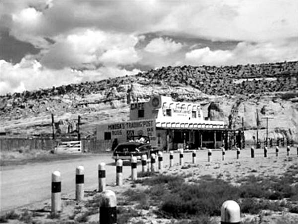
The studio built an enormous set including Indian Ruins, in Manuelito at the Lookout Point trading post (in the movie it was named "Minosa Trading Post") and they left it at the site once the film had been shot. The owner of the post used it as an attraction to lure tourists to his store.
It was first owned by the Kelseys of Zuni, and Alma Sue and Dan Watson ran it until Leroy Atkinson bought it and had Alma and her son run it. After 1953, new owners Chris and Morey Christensen changed the name to Cliff Dwellings Trading Post (1).
Years later Rex Bollin (Leroy's brother-in-law) bought it as a tourist attraction (2).
The movie screenwriters were probably inspired by Cave of the Seven Devils owned by Harry "Indian" Miller west of the movie location, by the state line which also had fake Indian ruins.
The Trading Post in the movie
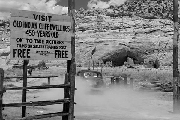
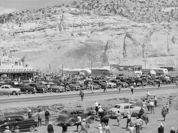
Below are some stills of the Trading Post from the movie, the cliff with the ruins" can be seen in the background.
Looking east from Route 66 towards the Trading Post. St. view nowadays.
At the trading post:
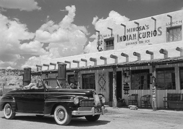
The entrance to the cave was on the eastern side of the property. The sign reads "Visit Old Indian Cliff Dwellings 450 Years Old OK to take pictures Films on Sale in Trading Post FREE Leo Minos Prop FREE". As the movie progresses, Leo's wife charges an entrance fee, that grows from 25 cents to 50 cents and finally one dollar. Notice the ruins by the cave's entrance at the foot of the cliff. This is a view of the same spot nowadays.
Looking north from Route 66 towards the cliff.
The trading post and the cave as the movie climaxes, with crowds of tourists, a 1950s-media reality! Route 66 runs across the image. People also came by bus and train to the site.
You can see the site of the trading post in this 1962 aerial photo. It was razed around 1970.
Drive west for 1.8 miles and see the site of a long gone trading post:
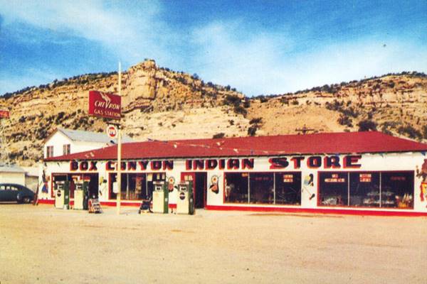
Box CanyonTrading Post ❌
The Red Box Trading Post was located on the right (north) side of the highway shortly before it curves to the right when it meets the freeway. Nothing remains of it, but you can see the spot in this St. view; it is pictured below.

Leroy and Wilemine Atkinson c.1950 NM Route 66. Source. Click to enlarge
Leroy "Bozo" Atkinson (1915-1994) met his future wife Edna Wilmerine Bollin (1917-1997) in high school where he was a football star. They got married in 1935 and moved from Grandview Texas to Gallup seeking better luck during the Great Depression. In Gallup he learned the business of trading with the Navajo Indians. After working at different trading posts he started his own, Box Canyon Trading Post in 1943 on land that he leased from Harry "Indian" Miller (Miller owned a trading post just down the road from here he was quite a character, more about him further down).
Business prospered after WW II and Leroy added som cabins, cafe and some gas pumps selling Chevron gasoline. He also owned a stake in the Lookout Trading Post and in the State Line Trading Post on the AZ-NM border by Lupton. However, after losing the "State Line" due to a right of way dispute with the Department of Transportation, he sold his properties and moved to Tucson AZ (3).
The old trading post here survived into the 1970s as you can see in this aerial photo.
Leroy had also brought his two brothers over from Texas and got them started in the trading post business. Herman owned the Cobra Gardens - Lost Canyon Trading Post in Milan NM, and Jake owned the Rattle Snake Trading Post in neighboring Bluewater.
Seven Devils Cave
Continue westwards for half a mile. Route 66 curves now, as it meets the freeway but in the past it followed a straight course marked with a red line in our map. At the curve is the "Devils Cave."
Harry "Indian" Miller
Harry Indian Miller had developed a Trading Post owned by Earl Cundiff in Two Guns Arizona in the early 1920s shortly before Route 66 was created. He claimed to have lived among the Philippine headhunters while he was in the Army during the Spanish American War (1898). He called himself "Chief Crazy Thunder" and said he was part Apache and part Mohawk.
Read all about Miller in our "Two Guns" webpage, learn about his zoo, Apache Death Caves, fake ruins and how he killed Cundiff in 1926 and was aquitted. He left Arizona and settled here in Manuelito on the New Mexico side of the state line beside Lupton. Here, he again built a fake cave in the sandstone cliffs the "Seven Devils Cafe", and it gave tourists an idea of what these buildings were like (4).
The seven devils are a typical reference to the seven deadly sins. Miller was savvy and knew what tourists wanted to see. The site housed an animal zoo with some of the animals coming from his former zoo in Two Guns. He built fake cliff dwellings too.
He also owned another zoo beside the Petrified Forest National Park on Route 66 in Arizona, the Painted Desert Park - The Lion Farm.
He remained here at the Devils Cave until his death in 1952.
Fort Chief Yellowhorse
After Miller's death, the place became Fort Chief Yellowhorse, opened by Juan Yellowhorse in the mid-1960s. He and his brothers developed the site and ran it until his death there in 1999. With his brothers he also built other stores in in Arizona and New Mexico.
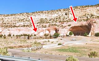
The property is still there. The red arrows in the image mark the "Seven Devils Cave" where the fake dwellings were and the wood palisade of the fort.
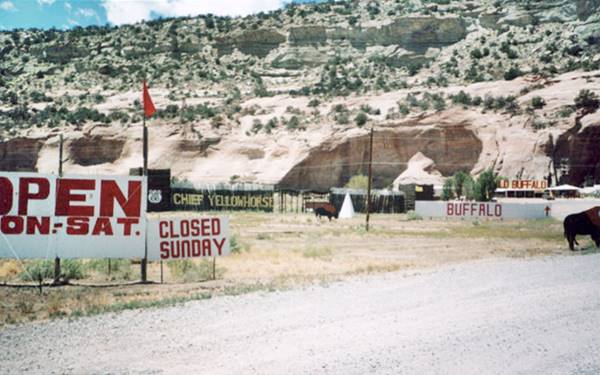
Just ahead, on the New Mexico side of the state line is the site of Atkinsons' last trading post.
State Line Trading Post
Leroy partnered with his brother Jake and they opened the "State Line Trading Post" right on the Arizona ⁄ New Mexico state line. He also leased the property from "Indian" Miller. They employed Armand Ortega to work on the post which also had a gas station. Ortega would learn the trade with the Atkinsons and move on to build his own chain of Ortega trading posts, starting in Lupton. Jake later moved to Bluewater to run his Rattlesnake Trading Post. See this 1952 aerial photograph of the property.
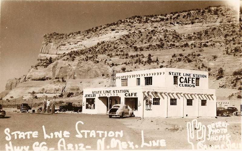
State Line Curios, Manuelito NM Route 66. Source. Click to enlarge
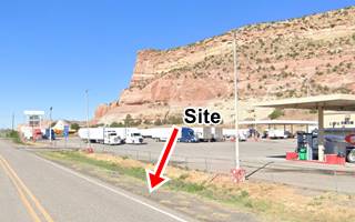
Some have said that Atkinson lost his legal battle with the D.O.T. regarding the right of way of the Box Canyon Trading Post, but that is incorrect. His dispute was about this site. He had sold this to the state several years before but said the price had been unfair. In 1953 the place was torn down because it lay right where the new frontage road had to be built. The freeway was going to be built here and the highway had to be realigned. The same cliffs can be seen in the background in both "Then and Now" images above.
Gateway Arch ❌
The last landmark travelers encountered as they left New Mexico was the "Archway", on the state line.

Come Again Arch at NM AZ state line. US 66 Lupton, 1938. Source
Click on image to enlarge
The main landmark in the 1940s was the arch or "gateway" arch across Route 66 with the legend "You Now Leave New Mexico, Come Again" and the "US 66" shield crowning it.
This iconinc landmark was here until 1955 when the highway was realigned, when it was removed.
Read about it in our Lupton AZ webpage.
Historic Marker on I-40
Official Scenic Historic Marker
For those driving eastwards along the freeway it is in the NM Welcome Area on eastbound lanes of I-40. See this map.
The Marker has the following text:
Manuelito Area. This area contained many Indian pueblos dating from about A.D. 500 to 1325, when it was abandoned. Navajos settled here by 1800. This was the home of Manuelito, one of the last of the chiefs to surrender for confinement at the Bosque Redondo Reservation near Fort Sumner. The Navajos returned here in 1868.
Continue your Road Trip in Arizona
The state line marks the end of your journey through Manuelito and New Mexico. Continue your road trip by heading west along Highway 66 into the Arizona and the village right by the state line, Lupton AZ.
Sponsored Content

>> Book your Hotel in Albuquerque

Credits
Banner image: Hackberry General Store, Hackberry, Arizona by Perla Eichenblat
Jack DeVere Rittenhouse, (1946). A Guide Book to Highway 66.
Source on Trading posts.


