Route 66 in Sanders AZ
Index to this page
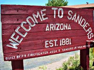
Welcome to Sanders sign. Source
About Sanders, Arizona
Facts, Trivia and useful information
Elevation 5,865 ft (1.788 m); population 712 (2025).
Time zone: Mountain (MST): UTC minus 7 hours. Summer (DST) no DST⁄ PDT (UTC-7).
Sanders is a unincorporated town in Apache county in the Navajo Nation in eastern Arizona, on Route 66.
History
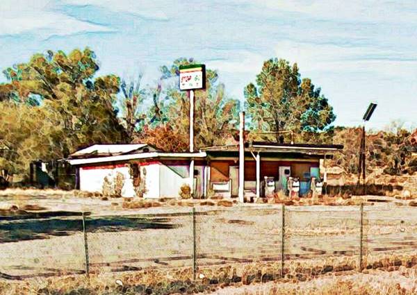
The now defunct "Stop Go Cafe and Filling Station" in Sanders, AZ. Route 66
The Anasazi or Ancestral Puebloans lived as farmers on the vast Colorado Plateau from 700 to 1150 AD. Their territory ranged from the the Colorado River in the west, the south of Nevada, Utah, Colorado to the north, the Rio Grande in Arizona on the east and the Rio Puerco, Puerco of the West and Little Colorado rivers in Arizona on the south.
They moved southwest into NM around 1300 AD pushed by a long dry spell and encroaching Indians from the north. They evolved into the historical Pueblo people encountered by the Spanish explorers in 1540 when Francisco Vázques de Coronado reached the area seeking gold.
Sanders is on the southern tip of the Anasazi territory; further south were the Mogollón, people.
The Navajo reached the area around 1400 AD. They called themselves Diné (or "People") and like the Apaches, belonged to the Athabaskan people from Northwestern Canada. They later moved into the Southwestern USA.
They were hunter gatherers who later bred sheep and goats (introduced by the Spanish), they learned agriculture from the Pueblo.
The Discovery of the Grand Canyon
Coronado sent a party of twelve men under García López de Cárdenas to check out the rumors about a great river to the west of Zuni Pueblo.
Cárdenas marched west from Zuni and crossed the Rio Puerco of the West near what is now Sanders. He reached the Grand Canyon with the help of Hopi guides and he and his men were the first Europeans to see the Grand Canyon and the Colorado River.
The Spanish occupied New Mexico in 1597 but never settled Arizona (which was a part of the province of Nueva Méjico). They encountered the Navajo in 1620, north of Santa Fe, and gave them their name: "Navajo" derives from "Apachu de Nabajo" (Apache of Nabajo).
The Navajo were warriors and raided the Spanish colonial villages and in Nueva Méjico, and continued doing so during the period of Mexican domination. After the U.S. annexed the territory, ceded by Mexico in 1848 it began a campaign to pacify the region.
Fort Defiance was established by Col. Edwin V. Sumner in 1851 as a military outpost in the Navajo territory in what is now Arizona. It was abandoned at the beginning of the American Civil War in 1861, when the Army retreated to New Mexico to face the Confederate threat.
A new base was established in 1862 near what is now Grants ("Old" Fort Wingate) and Brig. Gen. James Carleton conducted a campaign that starved the Navajo forcing them to surrender. They were then marched 450 miles (750 km) to an internment camp in NM ("The Long Walk"). The terrible conditions at the camp led to Carleton's dismissal, and a treaty was signed with the Navajo in 1868, which allowed them to return to their homeland which became the Navajo Reservation.
Apache County was created in 1879 and in 1895 Navajo county was split from it western part.
Regarding what is now Sanders, the Star Stage Mail route that linked Ft. Wingate in New Mexico with Fort Whipple (nowadays Prescott), ran along the south side of the Rio Puerco River with stops near Sanders at Navajo Springs where it met the old military route from Albuquerque through Zuni Pueblo, Jacob's Well and west towards Holbrook.
This was the trail used by Beale in his 1857 expedition.
Beale and the Camels
The expedition led by Lt. Edward Fitzgerald "Ned" Beale (1822 - 1893) to survey and build a wagon road from New Mexico to the Colorado River near present Needles CA and Tropock AZ, passed by the area where Sanders is now located, in 1857.He used camels, imported from Tunis as pack animals. Though hardier than mules, the camels scared both horses and mules. The Army decided not to use camels in the future.
The Atlantic and Pacific Railroad (Later acquired by the Atchison Topeka and Santa Fe Railroad), built a station here around 1883. Between Sanders and Houck there was another stop, named Querino. The post office opened in 1896 and was named "Cheto", it later closed to be reopened in 1936 as "Sanders". An Indian trading post ran by (coincidentially) Art Sanders was the first in the area in the 1880s.
The Navajo name was "Lichíí'í Deez'áhí", which means "Horizontal Red Area" due to the red colored sandstone and clays which according to a Navajo myth, gave their color to the local, and still abundant, red deer which was a staple food during their hunter gatherer days.
The Name: Sanders
The place and railroad siding was first named Sanders, after C.W. Sanders who was an office Engineer at the Atchison Topeka and Santa Fe Railway. Later the railway decided to change the name to Cheto as there was another station with the same name on the AT & SF system. And the siding is known as "Cheto" until this day.
Cheto
So the station was "Cheto" and the town "Sanders". There is even a mine (Cheto mine) that extracts a valuable type of clay used for drilling in the oil industry, a calcium bentonite, known as "Cheto" bentonite.
In 1926 Route 66 was aligned through the area following the National Old Trails Highway, and passed through Sanders, which it reached along the south side of the Rio Puerco. The 1930 roadbed was built on the north side of the river and passed a mile north of Sanders, beyond the railroad.
Surprisingly, in the 1915 Railway map the station figures as Sanders. And it also appears under this name in the Rand McNally road map of 1927, where it is shown as being located on an unpaved but graded highway (US Hwy. 66) 8 miles west of Houck and 15 mi. east of Navajo.
The Arizona State Highway Road Map of 1935, adjusted the distances (8 mi. to Houck and 13.8 to Navajo), it also shows that Route 66 had been paved. Modern US 191 (which until recently was the US Highway 666 at that time was a dirt state highway, AZ-61. Route 66 was later replaced by I-40 in the 1960s.

Where to Stay: Your hotel in Sanders
There is lodging along Route 66 very close to Sanders:
>> Book your Hotels in Chambers or in Holbrook
More Accommodation near Sanders on Route 66
There are plenty of lodging options in the cities and towns along Route 66 east and west of Sanders; click on the links below to find your accommodation in these towns, listed from east to west:
Eastwards
In Arizona Along Route 66
Westwards
You are so close to Las Vegas and the Grand Canyon!
>> There are RV campgrounds near Sanders, in Holbrook AZ
Weather in Sanders
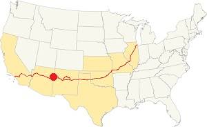
Location of Sanders on Route 66
Sanders' climate is semi-arid and dry. Summers are hot and winters cold. During the whole year, the day-to-night temperature swing is considerable due to the low relative humidity; this means that Summer nights are pleasant and cool, but winter nights are quite cold.
The average high temperature in summer (July) is 95°F (35°C). The average summer low is 59°F (15°C). The winter (Jan) has an average high of 50°F (10°C); with an average low of 21.9°F, below freezing (-6.1°C).
Not much rain falls; only 9.5 inches yearly (241 mm) and half of it falls during the Summer Monsoon period between July and October (5 inches - 127 mm). There are about 50 days with precipitation every year.
Snow is light (due to the desert) with about 6.5 in. per year (16.5 cm), and it falls between October and April.
Tornado risk
There is virtually no tornado risk in Sanders: Apache County has no Tornado watches. The area west of this point has no tornado events at all.
Tornado Risk: read more about Tornado Risk along Route66.
Map of Route 66 through Sanders Arizona
Visit our Lupton to Winslow page for the description of this alignment. Below is the color coded interactive map:
>> Custom map of Route 66 in Sanders

Houck to Chambers, detail of 1937 map (Sanders in the middle). Source
Click on image to enlarge
The alignment from Allentown along the National Old Trails (N.O.T.) highway was later adopted by Route 66 from 1926 to 1930 and is shown in this map of 1926-30 Route 66 from Allentown to Sanders.
Realigned in 1930 through Houck it followed this course Map (1930-65) Allenton-Houck. Then, beyond Houck and towards Sanders it took the alignment shown here: 1930 - 47 Houck - Querino Canyon - Cedar Point map.
West of the junction where Querino Rd. becomes the N. Frontage Rd., the original US 66 1930-47 roadbed is buried by the freeway (west of Sanders it also comprises the N.O.T. and 1926-65 US66). We marked this alignment with a purple line in our custom map of gaps in US66 alignments.
Route 66 Alignment near Sanders
With maps and full information of the old roadway.
- Winslow to Winona (next)
- Lupton to Winslow (Sander's)
- Albuquerque to Lupton (previous)

Sanders, Arizona, its Sights and Attractions
The land of the Navajo
Historic Context with Route 66
Sanders was never a large town; Jack DeVere Rittenhouse in his "A Guide Book to Highway 66" written in 1946 describes Sanders as having 88 residents, and added:
Sanders.... This town consists of the Tipton Bros. Store and two Gas Stations. Rittenhouse (1946)
He also mentioned more gas stations to the east, we will describe them below.
Into Sanders coming from Allentown
Trivia: Sanders was the "End" of Route 66 from 1979 to 1985
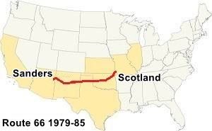
US 66 Scotland MO to Sanders AZ (1979 to 1985)
1979-1985 endpoints of Route 66:
East: Scotland, MO
West: Sanders, AZ
Route 66's western terminus was moved east starting in 1964 ( Read more on our Where does Route 66 start and end? page).
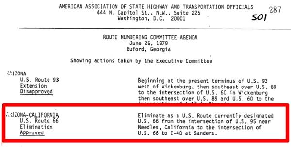
The American Association of State Highway and Transportation (or AASHTO) decided on June 29, 1979 to move the "end point" from Needles California eastwards across most of arizona Arizona, to Sanders, to its junction with U.S. 191 (see map).
The Western Terminus of Route 66 remained in Sanders until the whole highway was eliminated in 1985. When the higwhay was finally and completely eliminated when it was decommissioned on June 27, 1985.
Decertified in California and most of Arizona - 1979
Route 66 into Sanders
Heading west from Allentown, there are two alignments along Route 66:
- N.O.T. and 1926 to 1930 Route 66, a dirt surfaced back country road
- 1930 to 1947 Route 66, paved, that goest through Houck
1. The N.O.T. 1926-30 Route 66 alignment into Sanders
The original Route 66 followed the National Old Trails alignment and crossed the Rio Puerco at Allentown. Then ran along its south side all the way to Sanders, where it crossed the river again. See this map of 1926-30 Route 66 from Allentown to Sanders. It is a dirt surfaced back country rooad for high clearance vehicles. Drive it with care it is a rough dirt surfaced road.
Old Bridge (1923) at Allentown
Listed in the National Register of Historic Places
At Allentown the highway crossed the river using a bridge Built in 1923 as part of the National Old Trails Road. This
Map shows where it is. It had a wood deck supplied locally to reduce the construction costs.
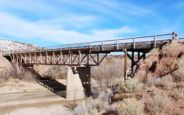
The Allentown Bridge was a Pratt deck truss bridge. Truss is the steel structure formed of triangular units that give the bridge its strength. A "Deck" truss is one where the deck (roadbed) is placed on top of the truss. And a Pratt truss is shaped so that the diagonal beams face towards the center of the bridge. The deck was built in wood, this was supplied locally and lowered the bridge's construction costs
It is closed to traffic, but you can see it to your left, on the eastern side of the modern bridge that replaced it.
The original alignment did not go through Houck, it passed well to the south of the village.
You can drive this segment along the original roadbed along Co. Rd. 7240, covering 15.5 miles along a rough back-country road with no services along it.
Reach Sanders along the old highway
As you reach Sanders you will have to backtrack a very short distance, and then drive through Sanders to continue your journey because the old bridge there, at the end of the 1920s alignment is closed to traffic.
Historic 1923 Bridge in Sanders
Listed in the National Register of Historic Places
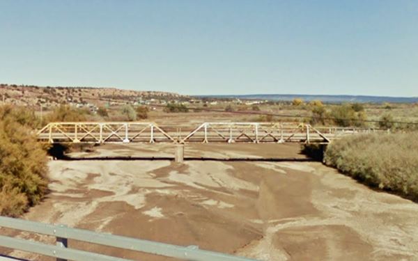
Built in 1923 on the Old Trails it also crossed the often flooding Puerco of the West River. It was a Pratt pony truss bridge. A "pony" is a bridge where the sides of the truss extend above the deck, but are not connected.
2. The 1930 - 1947 Alignment from Allentown to Sanders
This alignment ran along the north side of the Rio Puerco River, and in doing so, went through the small community of Houck.
The two 1923 bridges and the Old Trails alignment required improvement (the wooden deck wore out quickly), and a straighter and shorter route was desireable. So the Arizona Highway Department chose a route along the north side of the railroad, west from Allentown. It was built in 1929 and in 1930 it replaced the old segment, which is a now county road used by the Navajo reservation residents.
The segment from Allentown to Houck is buried by the freeway's westbound lanes built in the mid 1960s. However, some maps state that it runs along what is now the North Frontage Rd. into Houck we will follow this alignment; see the Map (1930-65) Allenton-Houck.
After passing through the scattered houses of Houck, Route 66 alignment continues as the north frontage Road and then departs from current I-40, running further north to cross Querino Canyon. You can drive along it westwards as shown in this 1930 - 47 Houck - Querino Canyon - Cedar Point map. We describe the trading posts and historic bridges along this segment in our Houck page.
2. Into Sanders along the 1930-1947-1960s US 66
Beyond Querino Canyon, the 1930 to 1947 highway continues towards the SW and meets the freeway, where it turns west as the North Frontage Rd. The original 66 here runs beneath the freeway towards Cedar Point, just ahead at Exit 341. In 1947, The Querino Canyon and the Lost Box Canyon segment was bypassed with the 2-lane upgrade of the highway that runs where the eastbound lanes of I-40 run.
Cedar Point
West of the junction where Querino Rd. becomes the N. Frontage Rd., the original US 66 1930-47 roadbed is buried by the freeway (west of Sanders it also comprises the N.O.T. and 1926-65 US66). We marked this alignment with a purple line in our map.
Cedar Point and Indian Ruins
Indian Ruins
Rittenhouse mentions, 3 miles west of the Querino bridge another establishment: "A building here houses some excavations of Indian ruins. Private enterprise." This is where Exit 341 is now located at Cedar Point. The building of I-40 here disturbed the buildings.
This 1970 aerial photo shows, from left to right, the foundations of the Log Cabin and zoo (left) , Ortega's Trading Post (Indian Ruins) and the Cedar Point trading Post (right).
Rittenhouse mentions the "Log Cabin Trading Post" and gas station was ran by Allen "Al" J. Berry who built it with logs in 1927 on the north side of Route 66. He was next to some Indian ruins and after excavating them, he put a fence around the site and charged visitors an admission fee to visit them. His matchcovers promoted "Wild Birds & animals... Beer Liquor." It had burned down in 1945, but Berry rebuilt it.

Log Cabin Trading Post, 1930s. Source
The remains of the foundations are on the north side of the freeway where the frontage road straightens to run beside I-40 (See satellite view above).
Ortega's Indian Ruins
There is a newer trading post and Navajo handicrafts store to the east of the old Log Cabin site, it was part of the Ortega family's string of trading posts along Route 66 it dates back to the mid 1960s. This one was operated by Armand Ortega. The Indian Ruins store is on the north side of the overpass.

Indian Ruins, Sanders Source
Cedar Point Trading Post
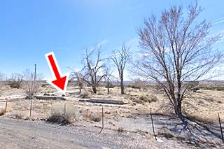
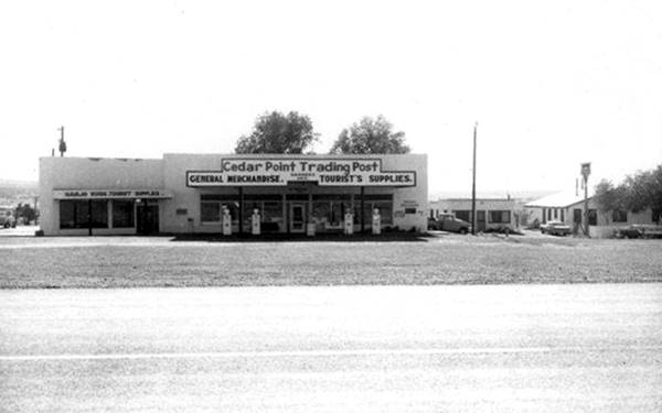
On the south side of the freeway was G. C. Wallace's "Cedar Point Trading Post", offering "General Merchandise, Tourist's Supplies, Navajo Rugs" and a Conoco Gas station. Below is a photograph taken in 1962, looking south from where I-40s eastbound lanes now run (at that time the 2 lanes of US66). The image above shows the same spot now, with the red arrow marking the foundations and part of the wall of the building.
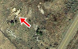
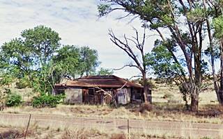
Heading one mile west, Rittenhouse mentions a "Gas station and garage" and at that spot are the remains of a building, east-sanders-gas to your right, on the north side of the frontage Rd. it is pictured below.

Map of US 66 at Sanders AZ, 1937. Source
Sanders
Just ahead, US 66 reaches Sanders. Described by Rittenhouse in 1946 as having 88 residents, "Tipton Bros. Store and two gas stations."
US 66 alignments meet in Sanders
The original 1926 and all the later alignments meet where Exit 339 is now located. The buildings at the junction of Route 66 with what is now US 191, that before was US 666 (more on this below) were razed when the freeway was built, with the overpass and ramps at Exit 339. The map above shows Sanders in 1937 (at that time US 191 was Arizona Hwy 81). All of these, and the depot named Cheto have gone.
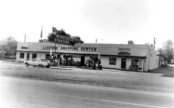
The 1953 phone book has an advertisement of "Ranchers Supply - General Merchandise CHEVRON Gas & Oil CURIOS Junction of Hghway 66 & 66 Sanders." Below it is pictured in 1962, when it was marked for demolition to make space for the freeway:
The Route of the Beast, U.S. 666
Once there was a spur of Route 66 (spurs add a digit in front of the US highway number so this was the sixth spur on US 66) into the Four Corners region: It was the U.S. Highway bearing the number 666 but on May 31, 2003, the American Association of State Highway and Transportation Officials approved a new number for it: the route became U.S. 491, a spur of U.S. 191.
Route 66 and U.S. 666 shared the roadbed between Gallup NM and Sanders in Arizona (where US 666 headed south all the way to Douglas on the Mexican border).
It was an unsafe highway and things were made worse by those D.U.I. But state officials thought that the cause was supernatural and voted to have the number changed for the following reasons:
WHEREAS, people living near the road already live under the cloud of opprobrium created by having a road that many believe is cursed running near their homes and through their homeland; and
WHEREAS, the number "666" carries the stigma of being the mark of the beast, the mark of the devil, which was described in the book of revelations in the Bible; and
WHEREAS, there are people who refuse to travel the road, not because of the issue of safety, but because of the fear that the devil controls events along United States route 666; and
WHEREAS, the economy in the area is greatly depressed when compared with many parts of the United States, and the infamy brought by the inopportune naming of the road will only make development in the area more difficult...
The reference to the Bible is from Revelations 13:18: "This calls for wisdom. Let the person who has insight calculate the number of the beast, for it is the number of a man. That number is 666."
Sanders downtown
Turn south along US 191, it crosses the railroad and the Puerco River. To your left you will spot the historic Sanders bridge over the river that we described further up, you can drive up to it for a good photo. (See our Sanders tour map.)
Sanders is a small town to your left, stretched out along the highway. The main attraction here is a former Valentine diner on E. Butte St., one block east of U.S. 191.
Valentine Diner
It is one of many along Route 66 (see the Valentines in Albuquerque and Edgewood, NM, nearby in Winslow AZ, and Clinton OK, just to mention a few). This is one of at least 2,000 built by the Valentine Manufacturing Company of Wichita, Kansas.
Arthur Valentine (1891 - 1954) invented them and began producing them in 1947. They were movable diners that came in different sizes and models. This model is an Aristocrat, that had eight seats.
The company gradually lost business in the 1960s and folded in 1975, the fast food chains and suburbia had displaced the small diners. There are several of them along Route 66.
This diner was expanded into a larger restaurant, that has closed. This map shows where it is.
Turn around and head back to Route 66 and the freeway.
Route 66 West of Sanders
West of Sanders te former roadway of Route 66 is overlaid by the freeway through Sanders and westwards (purple line in our custom map.)
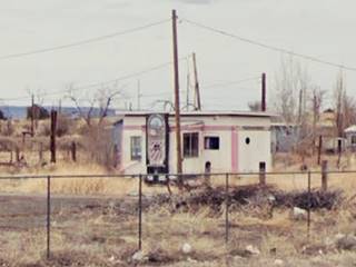
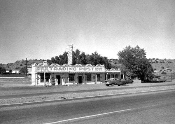
At the junction in Sanders, the Sanders Trading Post and Conoco gasoline service were located on the north side of the highway more or less where the school is now located. It had a box shaped stucco faced building with a Conoco station and behind it a low gable roof building. Below is a photo from 1968:
Stop Go Cafe: former Whiting Bros. station
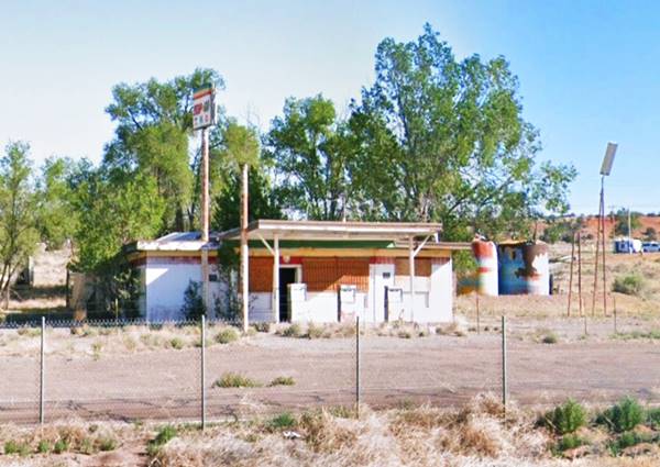
All that remains of the golden Route 66 days is a vacant former gas station and cafe on the N Frontage Rd. northwest side of the Exit, pictured below. The Arizona Route 66 Survey says it was built in 1965. The 1962 phone book mentions a Whiting Bros. station in town, here it is. Pctured below:
Former Whiting Bros. Station
Read more about all the motels and gas stations of Whiting Bros. on Route 66
White Elephant

Berry's White Elephant, Sanders AZ, 1940s. Source
The White Elephant was a lodge, bar and curio shop had been built by Mitchell Dickens and R.W. "Bob" Cassady Jr. They had run it as the Chamese Lodge. In 1948, Cassady was tried in 1948 for the bribes he paid to avoid prosecution "in the operation of a certain gaming device by the use of slot-machines at Chamese Lodge, adjacent to U.S. Highway 66, Apache County, Arizona" (Source).
After they went broke, it was acquired by Al Berry, of the Log Cabin Trading Post further east; his name appears painted on the building -see image.

Site of White Elephant Lodge. St. view
Click to enlarge
He sold it to Skeet and Maude Eddens; their postcard below says:"Skeet and Maude's White Elephant Lodge (Hi-way 66). 83 miles E. of Winslow, Arizona - 44 miles W. of Gallup, N. Mexico... Open 24 hrs. One stop. Cafe-Bar-Curios-Motel-Gas-Oil-Garage." The 1953 telephone directory mentions Skeet and Maude's White Elephant Lodge as being located in Chambers. These distances, considering the 1950s highway alignment would have placed it in the spot marked by this map and you can see the building (L-shape, upper right) in this aerial photo taken in 1969. The image below show the same bluff whose western and eastern tips can be seen in the two postcards, and nowadays.
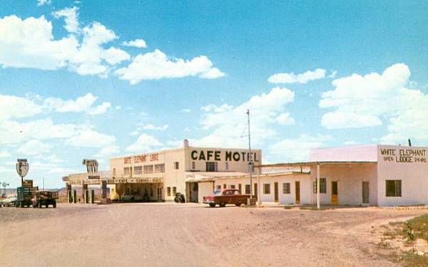
Next to it are the ruins of a bar or cafe (?) that can be seen in the 1969 aerial photo mentioned further up.
Continue your Road Trip
Just one and a half miles west, the highway's alignments part again at Navapache, which we describe in the next leg of your Route 66 road trip: Chambers.
National and State Parks, Outdoors
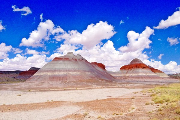
Petrified Forest National Park
Tip: consider visiting the Petrified Forest National Park (further west, as you approach Holbrook) during your Road Trip.
It is The Only National Park on Route 66

Lake Havasu City
Some sponsored content

Lake Havasu City, the lake and London Bridge. Source
The resort town of Lake Havasu City on Lake Havasu has beaches along the lake's scenic shoreline, an active nightlife and the original London bridge (you can take a Tour to visit it)
The adjacent state park is open 24 hs, and there is an entrance fee. It is located on a reservoir on the Colorado River. You can hike and enjoy the riverside.
Visit the scenic shoreline with beautiful beaches, nature trails, boat ramps, and many convenient campsites.
>> Book your Hotel in Lake Havasu City
Learn more about the outdoor sites in the Havasu State Park official website.
>> Book your Hotel in Holbrook AZ


Credits
Banner image: Hackberry General Store, Hackberry, Arizona by Perla Eichenblat
Jack DeVere Rittenhouse, (1946). A Guide Book to Highway 66
Stefan Joppich's The alignments of Route 66 through Arizona (2004).


