Leupp Corner. Route 66
Index to this page

About Leupp Corner, Arizona
Facts, Trivia and useful information
Elevation: 5,073 ft (1,547 m). Population: none (2025).
Time zone: Mountain (MST): UTC minus 7 hours. Summer (DST) no DST⁄ PDT (UTC-7).
Leupp Corner (it is pronounced "Loop"), is a place lcated at the junction of Arizona Highway 99 and U.S. Route 66. It is in Coconino County, in central Arizona.
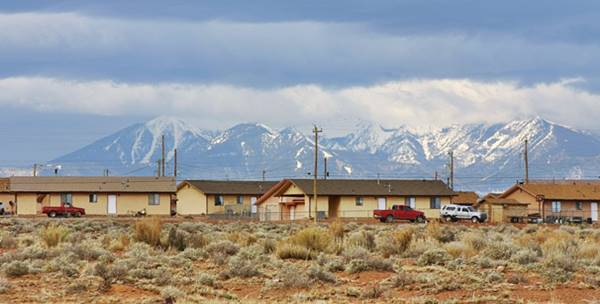
A view of Leupp, near "Leupp Corner" in Arizona, close to Route 66
For the early history of Leupp and Leupp Corner, please see the History of Winslow.
The Atlantic and Pacific Railroad, later Atchison Topeka and Santa Fe Railroad (AT&SF) laid their tracks through this part of Arizona in 1882, the stations of Moqui and Dennison were 3 miles east and west of Leupp Corner. The Navajo Reservation and the Hopi Reservation are both just north of Leupp Corner.
The town of Leupp was established in the Navajo Reservation in 1907.
The Name: Leupp Corner
It was the point where the road branched off (hence "corner") towards the town of Leupp.
Leupp is a Swiss German orign, a short form of Leupi, a Swiss pet form of Leopold.
The corner was a quiet spot on a cart trail and track that linked Leupp to Winslow. But Route 66 was routed through the area in 1926 and that brought a steady flow of travellers. The Hopi House Trading Post catered to their needs in the 1940s.
Getting to Leupp Corner
To the east are Winslow and Joseph City, To the west lie Winona (33 miles) and Flagstaff (48 miles). Drive along I-40 to reach Leupp Corner.
Where to Stay, find a hotel near Leupp Corner
There is no lodging on Route 66 in Leupp Corner, but you can find hotels nearby in Twin Arrows and Winslow:
>> Book your Hotel in Winslow
or
Twin Arrows
Lodging Near Leupp Corner along Route 66
There are plenty of lodging options in the cities and towns along Route 66 east and west of Leupp; click on the links below to find your accommodation in these towns, listed from east to west:
Eastwards
In Arizona Along Route 66
Westwards
You are so close to Las Vegas and the Grand Canyon!
>> There is a RV campground in Winslow and Barringer Crater
Weather in Leupp Corner

Location of Leupp Corner on Route 66
The climate of Leupp Corner is dry, temperate and arid. Relative air humidity is low and this leads to wide variations beween night and day temperatures all through the year, causing hot dry summer days but cool summer nights and cold winter ones.
During summer (Jul), the average high temperature is around 94.5°F (34.7°C) and the average low is 61.9 °F (16.6°C). In winter the average high (Jan) is 49.5°F (9.7°C) and the average low is about 20.8°F (-6.2°C), well below freezing pont.
As expected for an arid area, rainfall is scarce: 6.99 inches (178 mm) yearly and about half of it falls from July to September (3.1 in. - 79 mm). Snowfall is also light, with only 6.4 inches (16.3 cm) per year, between Oct. and April.
It is sunny in Leupp Corner, only 53 days per year are days with precipitation.
Tornado risk
There is almost zero tornado risk in Leupp Corner: Coconino County has no Tornado watches. The area west of the Rocky Mountains has virtually no tornado events at all.
Tornado Risk: read more about Tornado Risk along Route66.
Map of Route 66 through Leupp Corner Arizona
Read the Detailed Description of this segment (Winslow to Winona). Below is the interactive map:
>> Custom map of Route 66 in Leupp
The original Route 66 alignment from 1926 till 1965 ran along what are now the eastbound lanes of the Interstate, this Alignment map shows the course of the highway. There is another missing segment as it approaches Winslow, see the yellow line in our custom map with missing segments.
Route 66 Alignment near Leupp Corner
With maps and full information of the old roadway.
- Winona to Williams (next)
- Winslow to Winona (Leupp Corner's)
- Lupton to Winslow (previous)
Leupp Corner, Arizona, its Sights and Attractions
A place where once stood a Trading Post...
Historic context, the classic Route 66
In 1946, Jack DeVere Rittenhouse published his "A Guide Book to Highway 66" and described the road and its attractions and services for the travellers. He wrote the following about the segment west of Winslow:
Moqui
8 miles from Winslow was Moqui (location map) to the south of the Eastbound lanes of I-40. It was another place described as a "town" on the maps, but actually was only "a railroad siding with a few yellow board shacks".
Moqui or "Moki" was a name given to the Hopi people, it means "dead" in their language, but may have been applied to them by their neighbors, perhaps the Keresan speaking Pueblo people.
This name was recorded by Spanish explorers in the late 1500s: Espejo noted it down as "Mohace" and "Mohoce" in 1583, and by Oñate in 1598 as "Mohoqui".
Leupp Corner, is 11 miles from Winslow and the only building in the area by Route 66 was the Hopi House, which Rittenhouse described as a service station with an "affable, experienced" trader with "a fairly extensive stock". There were some Navajo hogans near it.
4 miles west of Leupp was yet another "town", Dennison, which was merely a siding with no gas, motels or services for the tourists. It was followed 3 miles to the west by Meteor City
Hopi House Trading Post (Gone)
The Hopi House trading posts had a Texaco gas station, cafe, a motel and a trailer campground. Below are two vintage postcards:
A now lost memory on Route 66: Hopi House Trading Post c.1950s
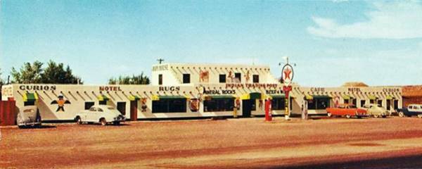
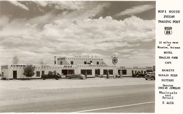
It was located to your right, on the north side of Route 66 at its junction with the access road to Leupp.
In 1941, Ray Meany had his Hopi House Trading Post built in a classic pueblo-revival style, with flat roof and exposed "vigas" - those roof beams that jut out of the wall, so common in the native Pueblo buildings; did you know that "viga" means "beam" in Spanish?.
Ray Meany (1906-1987), former sailor and later composer of Hawaiian music Aloha songs ran the Golden Gate Publishers with over 400 copyrights and owned a steel guitar school in Oakland California. He was the owner of the Hopi House in Leupp Corner (1944 - 1951) and also acquired the "Old Frontier" from Hubbell in Joseph City.
It was a shop that not only offered curios, rocks, Navajo baskets, pottery, genuine Indian jewelry and rugs, it also included a motel, a trailer park, a Texaco gas station and a cafe. The place also sold beer and wine.
It promoted itself as being on the "Main Entrance to Navajo and Hopi Indian Reservations... 10 minutes west of Winslow, Arizona".
But in 1955 Ray and his wife Ella divorced. He kept the Hopi House but later sold it to Armand Ortega, and with the proceeds, bought a motel in California. As the Meanys also owned the Frontier Trading Post in Joseph City (on Route 66) east of Winslow, Ella kept it as part of the divorce agreement.
Razed in the mid 1960s
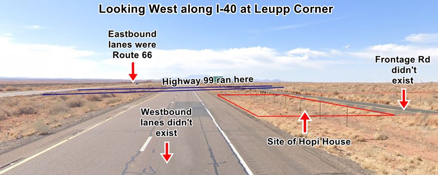
It was torn down to make way for the four-lane highway in the 1960s. This 1953 aerial photo shows that Route 66 ran along the current Eastbound lanes of I-40, the trading post was to the north. When the new two westbound lanes of I-40 and US-66 were added, they would have ran along its facade. The Frontage Road ripped would have cut across the back side of the building. So it had to go. It was torn down.
Remains of the old post
Some rubble can still be seen in the land north of the frontage Road. The image below shows where the old post would have been located (red lines), the original UDS66 (eastbound lanes of I-40), the extended roadway of highway 99 (blue lines) and the rear part of the property where the trailer park was located and where the rubble can be spotted (dashed red lines):
Site of Hopi House at I-40 and Hwy 99, Leupp Corner. Click on the image for large size picture

Rubble from Hopi House nowadays, click image to enlarge (St. view)
A view of the rubble where the old trailer park once stood, on the back part of the property north of the Frontage Rd. Click on image to enlarge. Red arrows mark some rubble.
Leupp
Pop. (2020) 1,216. Elevation 4,763 ft (1.452 m)
From Leupp Corner to Leupp Map (18.8 miles).
A small location in Coconino County, north of Route 66 which can be reached from Leupp Corner via AZ-99.
It is inside the Navajo Nation Reservation and its Navajo name is Tsiizizii.
The town was established close to where the San Fransico Wash met the Little Colorado River around 1907 when the Bureau of Indian Affairs (B.I.A.) opened a boarding school for about 500 Navajo children.
The Name Leupp
It was named after Francis E. Leupp, who was the U.S. Commissioner for Indian Affairs at that time (1905 to 1908).
This town is now known as "Old Leupp". The current town of Leupp is about 2 miles northwest. The old town had the school, built in red sandstone in the 1920s, the administrative buildings, a Presbyterian church, some residences, and a water tower and windmill (these two are still standing). Later a levee was built by the Civilian Conservation Corps to protect it from flooding, However, the school had closed in early 1942 because of its inconvenient location on the flood plain.
This is a Old Leupp location map.
The new town is on the west bank of the Little Colorado River, and there still is a B.I.A. Boarding school in the town (Leupp Schools, Inc).
Leupp Isolation Center
An Internment Camp for Japanese Americans during World War II
More World War II Camps along US66
There are two other camps along Route 66, some for POWs other for interning Japanese-Americans: the Santa Fe Internment Camp in New Mexico, and the German Prisoner of War Camp in McLean, Texas.
The U.S. government used the abandoned Bureau of Indian Affairs boarding school to intern Japanese Americans during World War II.
The inmates came from the Moab "Isolation Center" in Utah and from the Manzanar camp. These innocent Americans had been considered "noncompliant" or "disloyal" American citizens just because they were of Japanese ancestry!
During 1943, 41 men were moved to Leupp adn during the war, a total of 80 Japanese Americans were housed in the facilities until they were al moved to another camp at Tule Lake. The site remained open but empty of inmantes until 1944, when it was returned to the Department of Interior.
Internment of Japanese Americans
The heinous attack on Pearl Harbor on December 7, 1941, brought America into World War II. It was a surprise attack that unnerved the US and its people.
Paranoia and fear of the "Yellow Peril" created a strong anti-Asian feeling. Tens of thousands of Americans with a Japanese ancestry were uprooted, assembled and sent to "relocation" camps: barracks behind barbed wires in the desert area of the Southwest. About 120,000 Japanese Americans were sent to these camps and lost their homes, jobs, businesses for the duration of World War II. Nothing like this happened to German Americans, who were allowed to live in peace.
Continue your Road Trip
This marks the end of your visit to Leupp Corner, head west into Meteor City to continue your Route 66 Road Trip.
Nature and Outdoors
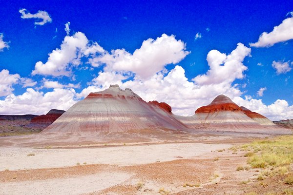
Tip: consider visiting the Petrified Forest National Park (near Holbrook) on your Road Trip.
The Only National Park on Route 66
Some tours and sightseeing
Consider visiting the Grand Canyon.
>> Learn more about the Grand Canyon National Park and US66
Sponsored content
Lake Havasu City

Lake Havasu City, the lake and London Bridge. Source
The resort town of Lake Havasu City on Lake Havasu has beaches along the lake's scenic shoreline, an active nightlife and the original London bridge (you can take a Tour to visit it)
The adjacent state park is open 24 hs, and there is an entrance fee. It is located on a reservoir on the Colorado River. You can hike and enjoy the riverside.
Visit the scenic shoreline with beautiful beaches, nature trails, boat ramps, and many convenient campsites.
>> Book your Hotel in Lake Havasu City
Learn more about the outdoor sites in the Havasu State Park official website.
>> Book your Hotel in Flagstaff AZ

Credits
Banner image: Hackberry General Store, Hackberry, Arizona by Perla Eichenblat
Jack DeVere Rittenhouse, (1946). A Guide Book to Highway 66.
Debra Redsteer, 28 June 2008 Leupp, Arizona: A Shared Historic Space for the Navajo Nation and Japanese Americans
J. Burton, M. Farrell, F. Lord, and R. Lord, Confinement and Ethnicity: An Overview of World War II Japanese American Relocation Sites Chap. 14


