Meteor City. Route 66
Index to this page
About Meteor City, Arizona
Facts, Trivia and useful information
Elevation 5,034 ft (1.535 m). Population 0 (2025) - no longer two!
Time zone: Mountain (MST): UTC minus 7 hours. Summer (DST) no DST⁄ PDT (UTC-7).
Meteor City is not a city, or even a town or village; it is what remains of a once popular dome shaped Trading Post on the south side of US Route 66 (just west of I-40's Exit 239) in Coconino County in central-eastern Arizona.
For the early history of Meteor City, please see the History of Winslow.
Towards the late 1800s, the wagon trail that linked Winslow with Flagstaff was surveyed and the Atlantic and Pacific Railroad, which later became the Atchison Topeka and Santa Fe Railroad (AT&SF). They laid their tracks through the area, just south of what would later become "Meteor City" in 1882. Dennison station was located 3 miles east of Meteor City and Sunshine was 4.5 miles west (the station is 1 mile north of I-40's Exit 233).
The post was just to the south of the Navajo Reservation and the Hopi Reservation.
The Name: Meteor City
The name "meteor" comes from the nearby meteorite impact crater, Barringer Crater, named after Daniel Barringer who suggested its meteoric origin when most believed it to be an extinct volcano.
City, is a rather pompous title because a "city" is an inhabited place of greater size, population, or importance than a town or village, and this city never had more than 2 inhabitants.
Route 66 was aligned through the area in 1926 following the National Old Trails highway. The road was realigned later and in 1938, the Trading post was built. The freeway (I-40) bypassed it in the late 1970s but an exit was built just east of it, giving easy access to the trading post.

Where to Stay. Find your Hotel near Meteor City
There is no lodging on Route 66 in Meteor City, but you can find hotels nearby in neighboring Twin Arrows and Winslow.
>> Book your Hotel in Winslow
or
Twin Arrows
More Accommodation nearby along Route 66
There are plenty of lodging options in the cities and towns along Route 66 east and west of Meteor City; click on the links below to find your accommodation in these towns, listed from east to west:
Eastwards
In Arizona Along Route 66
Westwards
You are so close to Las Vegas and the Grand Canyon!
>> There is a RV campground in Barringer Crater
Weather in Meteor City

Location of Meteor City on Route 66
The climate of Meteor City is dry, temperate and arid. Relative air humidity is low and this leads to wide variations beween night and day temperatures all through the year, causing hot dry summer days but cool summer nights and cold winter ones.
During summer (Jul), the average high temperature is around 94.5°F (34.7°C) and the average low is 61.9 °F (16.6°C). In winter the average high (Jan) is 49.5°F (9.7°C) and the average low is about 20.8°F (-6.2°C), well below freezing pont.
As expected for an arid area, rainfall is scarce: 6.99 inches (178 mm) yearly and about half of it falls from July to September (3.1 in. - 79 mm). Snowfall is also light, with only 6.4 inches (16.3 cm) per year, between Oct. and April.
It is sunny in Meteor City, only 53 days per year are days with precipitation.
Tornado risk
There is almost zero tornado risk in Meteor City: Coconino County has no Tornado watches. The area west of the Rocky Mountains has virtually no tornado events at all.
Tornado Risk: read more about Tornado Risk along Route66.
Map of Route 66 in Meteor City AZ
US 66 Alignments
Read the Detailed Description of this segment (Winslow to Winona). Below is the interactive map:
>> Custom map of Route 66 in Meteor City
1926 - 1937 US66
From Leupp Corner in the east, the original US66 highway ran west along the current eastbound lanes of I-40, then when it reached what is now Exit 239 where Meteor City is located it split from towards the Northwest along Red Gap Ranch Road.
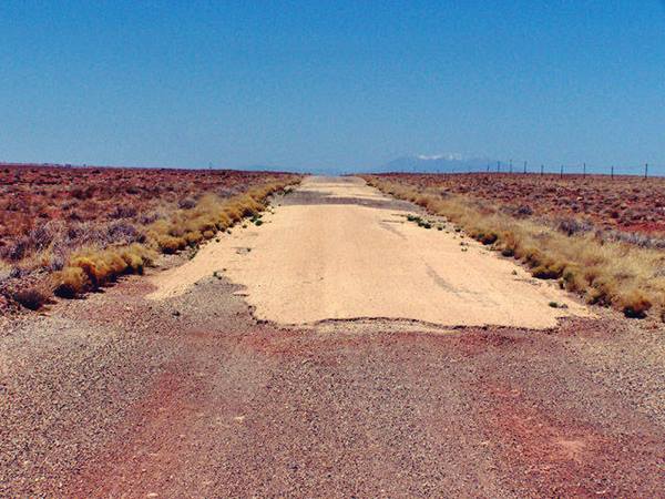
West from Meteor City the segment measures 2.5 miles, in a wide curve that returned southwards to cross the railroad (Red Gap Ranch Rd.) Nowadays it has a dead end on the east side of the railroad tracks where they meet the Freeway as you can see in the image below. This alignment is marked with a blue line in the map further down.
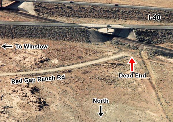
The original roadway crossed the tracks there, and headed towards what is now the south of I-40; the road then arches in a wide curve further south
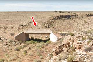
and then back again towards where I-40 is now located (black arch in the map above). It can't be driven but you can see this alignment in this map. There is concrete bridge at the western tip of this roadway -pictured above.
The original roadway curves across the freeway through the Westbound Rest Area on its north side.
You can see both gaps in the alignment (where it is cut by the freeway) in our custom map (yellow lines) with the missing segments along US66 in Eastern Arizona.
Meteor City on the Later 1940s - 1969 alignment
The road took another course after it was paved in 1935, it ran along what are now the Eastbound lanes of the freeway are located, and then after the tracks, it followed the older alignment (black line in the map above).
Route 66 Alignment near Meteor City
With maps and full information of the old roadway.
- Winona to Williams (next)
- Winslow to Winona (Meteor City's)
- Lupton to Winslow (previous)
Sights and Attractions in Meteor City
A dilapidated Trading Post...
Historic context, the classic Route 66
Jack DeVere Rittenhouse published his "A Guide Book to Highway 66" in 1946; the book describes the Mother Road and the roadside attractions; it is interesting to read his comments about US 66 west of Winslow. He mentions Leupp Corner with its Trading Post and Navajo hogans (huts) close to it. He points out that 4 miles west of Leupp was another "town" named Dennison, which was really a railway siding with no gas, motels or services for the tourists.
Three miles west was Meteor City with only one building which covered the needs of travellers: gas, food, curios. Rittenhouse wrote:
Meteor City. One building, offering gas, groceries and curios. For many years, a roadside sign here said "Population 2," but early in 1946, the operator of the "town" married, and the sign now says "Population 2." Rittenhouse (1946)
To the west of Meteor City, route 66 winded along the hills and reached Meteor Crater Observatory; this castle-like observatory which in now in ruins, in those days was quite an attraction. One mile to the west, Rittenhouse mentions Rimmy Jim's Service Station which had cabins, lunchroom and gasoline.
Meteor City's claim to fame...
Closed and abandoned, the place has fallen into disrepair over the yearws and has been looted by bypassers; the glass on windows and doors was broken, the furniture and cabinets have been ransackled and plundered. Now it is slowly coming back to life, restored by its current owneres.
The trading post has (or had) some interesting features which are (or were) worth seeing:
- The Longest map in the world of Route 66 (Gone)
- The "Dream Catcher"
- The dome shaped building
- The wigwams
The Meteor City Trading Post
The original "Meteor City Indian Trading Post" got its name from the nearby Meteor Crater, 22 mi. by road, to the southwest.
In 1938, after the terrible years of the Great Depression and the Dust Bowl, things began to improve slightly and on Route 66's twelfth anniversary, Joseph Sharber opened a Texaco service station on the midpoint between Winslow and the Meteor Crater he gave it the pretentious name of "Meteor City".
The "smallest town on Route 66"
In 1941 Jack Newsum (1900-1960) took over from Sharber and opened a curio shop that sold Navajo Rugs, Indian Jewelry, and petrified wood he operawted a Texaco station. Below is a picture of the spot from a newspaper article published on June 21, 1942 with a joking title "Population -- 1", the image was captioned One less citizen and there would be no sign."
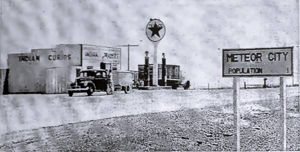
As reported by Rittenhouse, this was the sign next to the trading post announcing a population of one. "Lonesome Jack" was Newsum's monicker and he put it in his paper and magazine advertisements.
But Love found a way to Jack's lonely heart and he met Goldie Pearl Moman (1904-1967) so he changed the sign to "Two" when they married in 1946. This was published in many U.S. newspapers as a curious piece of news as reported in the Spokane Daily Chronicle:
CITY'S POPULATION GROWTH TERRIFIC. FLAGSTAFF, Ariz., Feb. 2 1946 (AP). For several years a sign about 30miles east of Flagstaff has read: "Meteor City, Population One." But that's improved now by 100 per cent. Lonesome Jack Newsome, the sole resident, married Goldie Moman of Andalusia, Ala., last week. The sign now reads: "Meteor City, Population Two."
Comments Jack: "We have left room on the sign for further changes - maybe we'll even get a larger sign".
Jack served as the local Justice of the Peace until he became ill at which time his wife Goldie stepped in the position. Goldie was known as "The wicked witch of Route 66" because of her no-nonsense attitude for handing out speeding tickets at Meteor City.
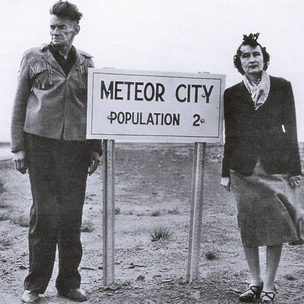
The business was thriving in the late 1960s (picture below) at the time of Goldie's death.
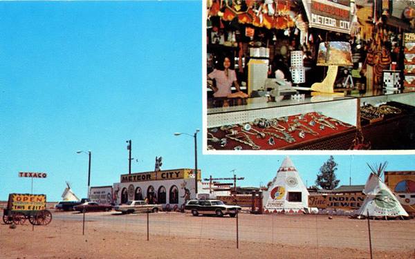
Onership of the trading post changed hands after Goldie's death. And after that date a dome replaced the original building.
The dome shaped building
A dome was built to house the trading post. This dome is peculiar because it has a crest running along its upper part; which is quite unusual in geodesic domes.
Geodesic Dome
A geodesic dome is a building with a shell structure shaped like a sphere or partial-sphere. The shell is based on a network of great circles (called geodesics) that intersect forming triangles on the surface of a sphere.
In practice, to simplify construction, all of the triangles have the same size. They provide rigidity and are light and stable.
The first geodesic dome was designed by Walther Bauersfeld in Germany in 1926 to house a planetarium. In the U.S., R. Buckminster Fuller named the dome "geodesic", studied it from a mathematical point of view and patented it in 1954.
The crested dome
There were several domes along Route 66 -more on this below, and all of them sported a crest; why? There is a local Navajo mythical masked dancer (Kachina) that wears a helmet-shaped mask with feathers along its centerline marking a crest. Perhaps this inspired the crest on the dome.
The movie "Cars" and its Dome
Disney Pixar's animated film "Cars" (2006) included a building in Cars Land that is strikingly similar to both Lupton and Meteor Crater domes; it is Fillmore's Taste-In drink stand. It even has a wheel-shaped "dream catcher" on the gateway.
First Dome at Meteor City
A geodesic dome was built in 1979 and you can see it in this aerial photograph from 1980. It sported a crest along a circular arc of 90° that over the years has been decorated with words or colorful designs.
The movie: Starman was not shot here
Many online sources claim that the Meteor City dome appeared as one of the locations in the 1984 movie "Starman", with Jeff Bridges.
In the movie you can see a dome and its interior. Below are two stills from the movie. Cllick on the link below to see a video with stills and snippets of those scenes.
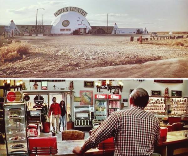
But Meteor City wasn't the location. These scenes were shot at the dome in neighboring Barringer Crater
Bridges was nominated for the Academy Award for Best Actor for his role. A TV series spun off the movie (1986).
"Starman" was directed by John Carpenter, produced by Larry J. Franco and Michael Douglas on a screenplay by Bruce A. Evans and Raynold Gideon.
Jeff Bridges played the part of an alien (Starman) who visited Earth after intercepting the gold disk carried by the spacecraft Voyager 2, launched in 1977. The disk carried a messag of peace and showed where Earth was located.
The alien's craft is shot down by the US Air Force and Bridges crashes in Wisconsin, befriends a local widow (played by Karen Allen) and contacts his people who arrange to pick him up at the Barringer Crater in Arizona.
The movie is about the relationship between alien man (in a cloned human body) and human woman as they try to get to Arizona despite the U.S. forces sent to intercept them.
Different Domes
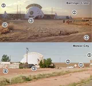
The dome at Barringer Crater is almost identical to the dome at Meteor City, but you can tell them apart by comparing the movie's dome to Meteor City's trading post:
- In the movie there is no paved road visible close to the Dome, there is a wide gravel drive and then, 200 ft. away is the paved highway (access road from I-40 to the meteor crater). The Meteor City dome on the other hand has had a strip of highway (frontage Rd.) running right beside it (50 ft.); it was built in the 1970s, long before the movie was shot.
- The movie scene has three tepees to the right (the last one is seen in the distance), and they can be seen in this 1980 aerial photo. The Meteor City had no such tepees 1980 aerial photo
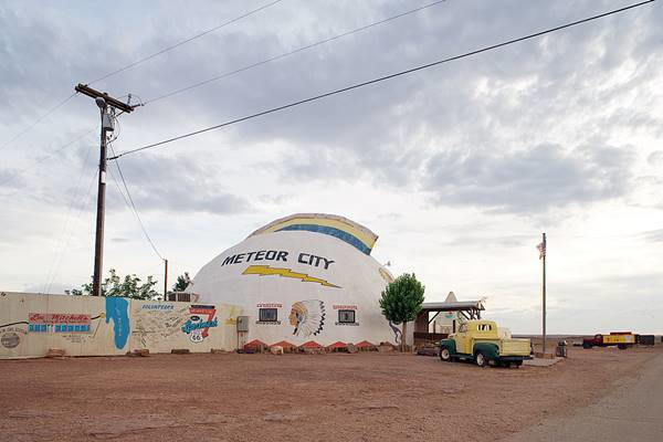
- The two windows in the Meteor Crater dome are long and close together (see the image below), the ones at Meteor City are square and far apart (see the picture further down)
- The scene shows a tepee to the left, but Meteor City had no such tepee (see aerial photos). The wall to the left on the movie is straight, Meteor City's wall is "L" shaped.
- The sun is setting in the movie scene to the left of the image since the sun sets in the West, this is correct for Meteor Crater RV camp, it sets to the left. But in the Meteor City dome, sun sets to the right, where the number (5) is placed. This is the most defining piece of evidence.
The Meteor Crater location scene nowadays (crest has gone), notice the two windows, close together and rectangular.
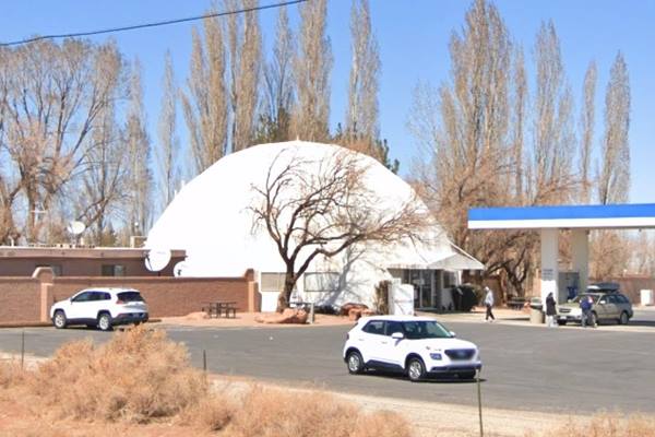
The Meteor City trading post in the 2006 when the "longest map" in "good shape" (to the left), notice the square windows
Was there a Second Dome in Meteor City?
All of the information on the internet and even in publications about Meteor City state that the original dome burned down in 1990 and was rebuilt shortly after. Suprisingly, Judi Kempton and Dale Screivner who owned the trading post from 1989 to 2001 wrote in 1993 (Source) that "Our store is a 60' diameter geodesic dome originally constructed in the late 1960s." Judi would have known if the place had burned down in 1990. An interesting point is her surname, Kempton, it is very likely that Judi was related to Carl Kempton, dome builder and trading post owner.
The Other Domes along Route 66 in Arizona
Carl Kempton (1943-2019) moved to Lupton AZ, at the age of 15 and lived with the Ortega family; they were in the trading post busienss. After two years service in Vietnam he returned home and built his store business along Route 66. He was a partner with Gilbert Ortega in the Geronimo Indian Village, later Geronimo Indian Store in Lupton since 1967 [1]. This store was a geodesic dome! it burned down on November 7, 2021 [2]; this store is pictured below.

Ortega's dome-shaped store on US66, Lupton AZ. Source

Ortega's dome-shaped store on US66, Houck AZ in 1979. Credits
There was a string of these domed stores and Trading Posts along Route 66 in eastern Arizona, all of them built in the late 1960s: Lupton, Allentown, Meteor City, and Barringer Crater all had a dome. And all of them were linked to Gilbert Ortega.
Eight miles west of Lupton along Route 66 was the Allentown Rd. Dome in Houck, it was already standing in 1969 (See aerial photo). The dome was replaced by the current building between 1981 and 1997. It is still operating as "Ortega Indian City Arts". John Margoulis pictured it in 1979 (above) while it was a dome, with the same design as Meteor Crater's dome.
Gilbert Ortega Sr. (1936-2003) a fourth generation Arizonan started working at his father's trading post in Lupton. He built his first store in the mid 1960s (Allentown's?) and developed the Indian jewelry retail and wholesale business. By 1977 he had 16 stores but refocused on high-level fine stores after the 1980s [3].
The dome in Meteor city is reported as owned by Dennis Ortega in 1978, who happened to be Gilbert's brother.
The final dome is located at the RV camp in Barringer Crater. There is a sign there see a picture that states "The dome at Meteor Crater RV Park was built in 1968... Built by Carl Kempton in 1968." It adds, correctly that this was the dome used in the scene of Starman.
Difficult Times
The porperty was purchased by Emelia and Richard Benton in 2002 and they operated it until it closed again in December 2012. Joann and Mike Brown became the new owners in 2017 and are continuing to restore the property since then and until today. I'm unsure if the place is open or not, but it's worth a stop as a photo stop even if it isn't open at the moment.
You can follow up on their restoration and fund it buying souvenirs on their MeteorCity66 Facebook page.
More sights at Meteor City
World's longest Route 66 map
Gone, it has collapsed.
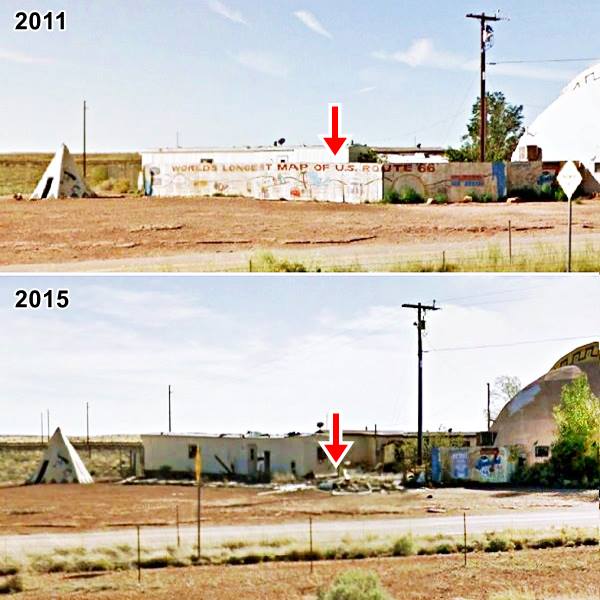
On the southeastern side of the dome once stood an L-shaped wall that sported the "World's longest Route 66 map". It was in very bad shape as you can see in the following image:
Then and Now view of the "World's Longest Map of U.S. Route 66" in Sept. 2011 and as it stands (or lies in rubble) in April 2015.
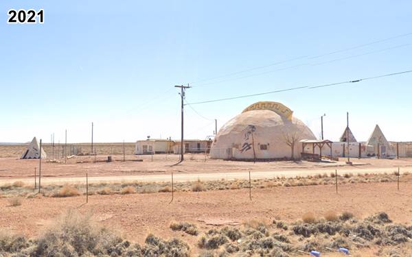
Now the place has been cleaned up, no wall, no mural, gone for good:
The Mural and its ruins have gone, 2021.

The Meteor City's longest map of US66 in 2006, by A. Whittall using pictures by Sean Evans. Source
Click on image to enlarge
The mural map was painted by Robert "Bob" Waldmire, an American cartographer and artist devoted to Route 66.
Bob Waldmire
Bob Waldmire (1945-2009). His mom and dad invented the corn dog in the 1940s and named it "Cozy Dog", selling it at their Cozy Dog Restaurant in Springfield MO, on Route 66.
Bob worked at his parents restaurant but later became an artist, traveling as a nomad in his school bus along Route 66. He retired in Hackberry CA, where he owned the General Store and continued working towards the preservation of Route 66.
His 1972 VW microbus inspired the character "Filmore" in the 2006 movie Cars.
A Route 66 Mural in Pontiac Illinois was painted in his memory, in 2009 by his friends and family.
The map was 100 feet long (30.5 m), so it was not actually the "longest" Route 66 map.
Repaired in 2002

Angel Delgadillo restoring the mural in 2002. Credits
The mural had gradually fallen into disrepair and it was repainted by volunteers enrolled in the Hampton Hotels "Save-A-Landmark" campaign on October 23, 2002; they also restored and repainted the wigwams. One of those who volunteered was Angel Delgadillo (pictured). Angel, born in 1927 owned a store in Seligman AZ, and is known as the "Guardian Angel" of Route 66. He is the main force behind the creation of the Historic Route 66 Association of Arizona, established in 1987 to save "Historic Route 66" when Seligman was bypassed by I-40.

Trovatore motel, Kingman AZ "World's Longest Route 66 map". Credits
Current Longest Route 66 Map
Trovatore Motel in Kingman Arizona
The honor of displaying the Worlds longest Route 66 map goes to the 1939 El Trovatore Motel, on Route 66 in Kingman, Arizona.
The Map is a mural that is 206 feet long (62.8 m) and covers the front of the entire motel. It was painted by local artist Dan Louden.
The "Largest" dreamcatcher
A dreamcatcher is a circular frame decorated along its rim with a net or web strung across its interior. Its purpose is to help you sleep in peace by hanging it next to your bed. The web snares nightmares and lets you sleep quietly.
There is a dreamcatcher, which allegedly is the largest in the world, located just to the northeast of the dome, between old Route 66 and the freeway.
However, Guinness proclaims as the largest dreamcatcher, one located in Dubingiai, Lithuania. It is 34 ft. 2 in. in diameter (10.14 m).

Largest Dreamcatcher. Credits

Tepee, Meteor City. Credits
The Wigwams
There are still some wigwams on the property. You can see some of them in the following image.
What is interesting is that the Arizona natives never lived in wigwams, they were used as a Route 66 marketing gimmick to lure in city slickers.
Wigwam, Tepee and Hogan
A wigwam is a native shelter made from a pole structure covered with bark. It is usually used as a synonym for tipi or teepee, but they are not the same.
A teepee is a conical tent used by the natives of the Great Plains. It is made with animal hides set upon wooden poles. They have smoke flaps a the tip of the cone. The word "tipi" means "dwelling" in Lakota language (Thípi) and the word "wigwam", derives from the Algonquian "wikewam", with the same meaning.
The local Navajo natives did not use wigwams. They lived in houses called "hogan": a round or polygonal shaped building with timber or stone walls packed with earth, a door facing east and a bark roof.
Continue your Road Trip
This marks the end of your stop at Meteor Crater, head west intoTwo Guns to continue your Route 66 Road Trip.
Nature and Outdoors
Tip: consider visiting the Grand Canyon (near Flagstsaff and Williams) and Petrified Forest National Park (near Holbrook) on your Road Trip.
Lake Havasu City

Lake Havasu City, the lake and London Bridge. Source
The resort town of Lake Havasu City on Lake Havasu has beaches along the lake's scenic shoreline, an active nightlife and the original London bridge (you can take a Tour to visit it)
The adjacent state park is open 24 hs, and there is an entrance fee. It is located on a reservoir on the Colorado River. You can hike and enjoy the riverside.
Visit the scenic shoreline with beautiful beaches, nature trails, boat ramps, and many convenient campsites.
>> Book your Hotel in Lake Havasu City
Learn more about the outdoor sites in the Havasu State Park official website.
>> Book your Hotel in Flagstaff AZ


Credits
Banner image: Hackberry General Store, Hackberry, Arizona by Perla Eichenblat
Jack DeVere Rittenhouse, (1946). A Guide Book to Highway 66.
February 2, 1946, Spokane Daily Chronicle


