Niangua, the Bear River
Index to this page
About Niangua Missouri
Facts, Trivia and useful information
Elevation: 1,440 ft (439 m). Population 405 (2010).
Time zone: Central (CST): UTC minus 6 hours. Summer (DST) CDT (UTC-5).
Niangua is a small town in northern Webster County, in southwestern Missouri.
Route 66 does not go through the town, instead, it passes 1.2 miles to the west of it through Niangua Junction, this is because the town was platted next to the railroad, while the highway took a shorter route.
History of Niangua
Read about the region's history in our Marshfield page.
The name: Niangua
Niangua (formerly named Miteomah) takes its name from stream which runs close to it which was named after the Osage word for "bear".
The area was surveyed in 1870 by the South Pacific Railroad Co. and shortly after John J. Redmond built the first general store. Shortly after, the Atlantic & Pacific Railroad reached the area and built a station there, 6 miles north of Marshfield. The post office opened that same year and was named Niangua.
Route 66 was created in 1926, and passed just west of the town.

Find your hotel close to Niangua Marshfield, Missouri
There aren't any hotels or motels in Niangua, but you can find your room in neighboring Marshfield, 6 miles to the west along Route 66.
> > Book your hotel in Marshfield
More Lodging close to Niangua on Route 66
There are several hotels in the area close to this town. Alternatively you can also find your accommodation along Route 66 in the neighboring towns and cities in Missouri. We list them below (from east to west):
On Route 66's Main alignment in MO
Eastwards
Westwards
- Hotels in Kansas
- Baxter Springs KS
- Galena KS
- Riverton KS
- Hotels in Oklahoma
- Miami OK
>> Check out the RV campgrounds in Marshfield
Weather in Niangua
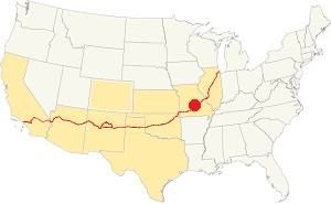
Location of Niangua on U.S. Hwy. 66
Niangua's position on the northern limit of U.S.'s humid subtropical climate gives it very humid weather during late summer.
The July average temperatures (summer) temperatures are: (high) 89°F (31.6°C); (low) 68° (19.8°C). The aerage January (winter) high temperature is 43°F (6.1°C) while the average low is below freezing: 22°F (-5.3°C).
Annual rainfall averages 45.6 in. (1.160 mm), and Niangua receives about 17 in. of snow (43 cm) every year.
Tornado risk
Niangua is located in the "Tornado Alley" and Webster County has around 9 tornado strikes per year.
Tornado Risk: read more about Tornado Risk along Route 66.
Map of Route 66 through Niangua, Missouri
Route 66 Map and its alignment
See this map of US66 in Niangua.
The original 1926-53 alignment runs in a north-south course from Sampson, through Niangua Junction and southwards to Marshfield. The highway was later realigned as a 4-lane highway in 1953, further west, and is now buried under I-44.
The alignment in Niangua
Visit our pages, with old maps and plenty of information about US 66's alignments.
- Springfield to Joplin (next)
- Rolla to Springfield (Niangua's)
- Gray Summit to Rolla (previous)
Route 66 Sights in Niangua
Landmarks, Attractions and Places to See on your Road Trip
Historic context, the classic Route 66 in Niangua
Jack DeVere Rittenhouse published his "A Guide Book to Highway 66" in 1946, and it left us a clear description of the Mother Road during during its heyday. He does not mention Niangua, but he did mention some landmarks.
Abbylee Court and Cafe... Oak Vale Court, with gas and cafe Rittenhouse (1946)
Tour the route 66 landmarks in Niangua
We will tour Niangua coming from the east (Sampson) and heading west towards Marshfield.
Abbylee Court
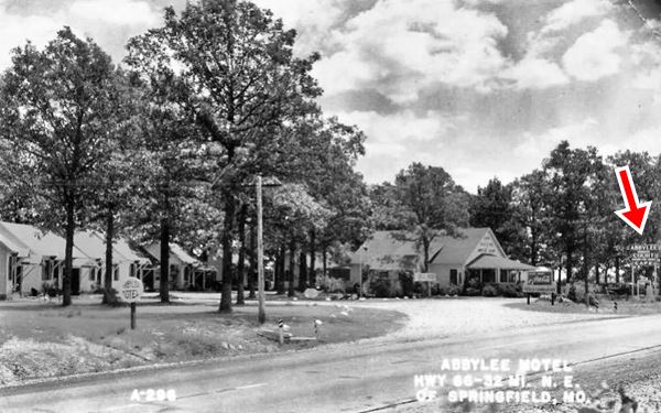
Just 2.5 miles south of Sampson, to your left, at Highway CC (Old Route 66) and Deerfield Dr. is the first landmark, Abbylee Court mentioned by Rittenhouse.
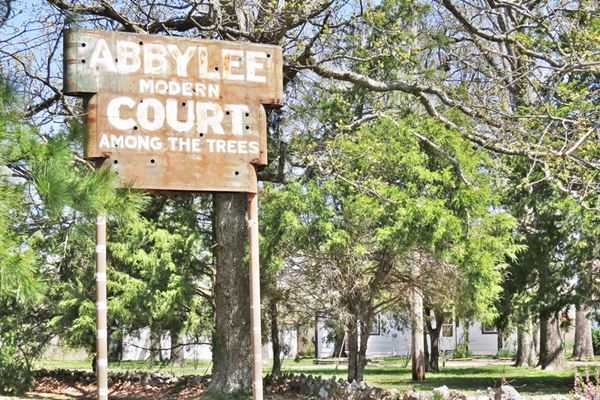
This motel or auto court, as they were known at that time, was built in 1940. It had eight cabins each with three rooms, with gabled roofs. The office was located in the center, with the cabins facing a circular gravel drive. There was a cafe which burned down after 1950 (one cabin was lost in the same fire).
This was a "strictly modern" business with "good food". Ritten house mentions the "Abylee Court and Cafe" in 1946.
The original sign proclaiming "ABBYLEE MODERN COURT Among the Trees" is great for a photo. Below is a 1940s photo, the sign is on the right (red arrow).
Niangua Junction Service Station
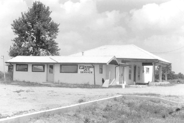
Drive south for 0.6 miles and, to your right is what used to be a gas station, at "Niangua Junction". The town is one mile to the southeast (left) along the road facing the gas station (Main St.)
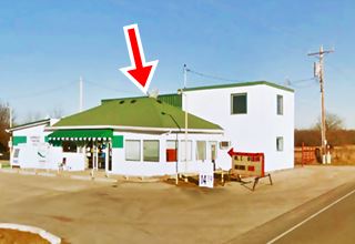
It is listed in the 1993 Survey of Missouri Route 66 as a gas station and Convenience Store. It was built in the mid 1930s, the original building is the hipped roof structure (red arrow in image). Additions were built to the left and right of it. As you can see below, its hipped roof extended forward over the pump island as a canopy, but has been removed.
In 1955 a service bay was added to the right, and now it has become a two story building.
A convenience store was added to the left and blended under the same hipped roof.
It sold ice, cold drinks and Marathon brand Tires back in 1938. At that time it was owned by Clyde Hagan. Later, from the mid 1940s to 1952 it was ran by Don DAvis. He sold it to Jack Clair who sold Tydlol and later Skelly gas until 1956. At that time US66 was realigned along what is now I-44, bypassing Niangua Junction.
Head south towards Marshfield to visit "Rockhaven".
Rockhaven Restaurant, cafe, and filling station
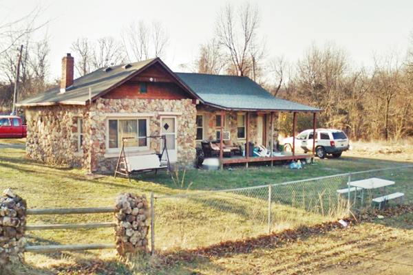
Highway CC (Old Route 66), 1.4 mi. south of Niangua Jct., to your left, on the eastern side of the road next to a wide bend opposite the Jehova's Witness place of worship.
Thie site is now private property, it was built around 1925 as a one floor wood structure bungalow styled building. It has broad gabled roofs and rubble rock walls.
The Ferriers owned it during the 1920s and they leased it as a Conoco Service Station in 1932. In 1938 it was a Texaco. It changed owners many times and operated not only as a filling station but also as a tavern, restaurant, and cafe, with some cabins too. It remained open until the mid 1960s.
Former Rockhaven Restaurant, cafe, and filling station in Niangua
Drive 200 yars south, towards Marshfield and visit a 1930s Service Station, Oak Vale Park a former café, service station and camping spot with cabins.
Oak Vale Park
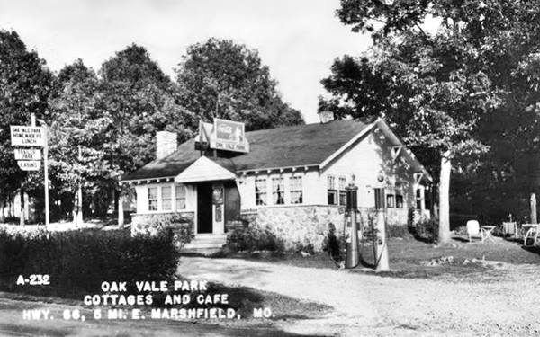
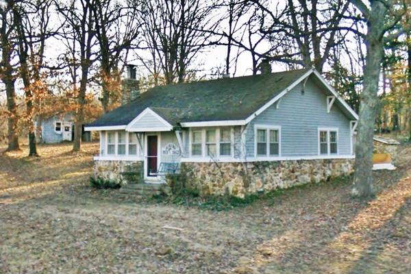
At 3652 State Highway CC (Old Route 66), to your left, on the eastern side of the road. Two cabins are still standing, as you can see in the picture.
Built in 1932, it was also known also as Carpenter's Camp. It has a one floor building with a steep pitched gable roof that is a typical example of a Craftsman style cabin with local rock foundation wall.
Fred and Margaret Carpenter bought the place in 1936 and opened a Skelley gas station with a café. In 1939 they sold it to Florence Onstott, who renamed it "Oak Vale Park" and switched to Sinclair gasoline and added the cabins. It later changed hads several times until it became a private residence.
Rittenhouse mentioned it as the "Oak Vale Court with gas and cafe." Below is a "Then and Now" sequence of this landmark.
Vintage postcard of the Oak Vale Park
The Oak Vale Park site nowadays
Continue south to visit yet another Route 66 "relic", a cottage-style gas station.
Niangua Filling Station
Cottage style Niangua station nowadays
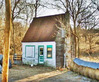
It is located on Old US 66 (Hwy. CC) 2.2 mi. southwest of Niangua Jct., to your left.
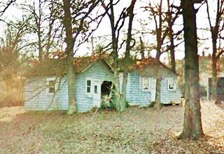
It looks like a cottage with a steep pitched gable roof, a stone chimney and wood siding. There is a window in the attic too.
Built ca. 1930 when gas stations were designed to blend in with the local neighborhoods, and therefore had a "cottage" look or a rural Picturesque style. Although abandoned it is still standing.
Historic 1924 Bridge
Next to the gas station, west. This is a bridge built two years before Route 66 was created, it is a Pony Truss steel bridge and crosses Niangua River; see its street view.
Your city tour of Niangua ends here, head west along Route 66 and continue your road trip into Marshfield.

Some sponsored content
> > Book your Hotel in Lebanon

Credits
Banner image: Hackberry General Store, Hackberry, Arizona by Perla Eichenblat
Jack DeVere Rittenhouse, (1946). A Guide Book to Highway 66
Architectural - Historic Survey of Route 66 in Missouri and Detailed Survey, Maura Johnson. 1993
Missouri: The WPA Guide to the "Show Me" State


