"Gateway to Opportunity"
Index to this page

TheRoute-66.com is reader-supported. When you buy through links on our site, we may earn an affiliate commission at no additional cost to you.
About Strafford Missouri
Facts, Trivia and useful information
Elevation: 1,490 ft (454 m). Population 2,358 (2010).
Time zone: Central (CST): UTC minus 6 hours. Summer (DST) CDT (UTC-5).
Strafford is a small town on Old Route 66 in western Greene County, in southwestern Missouri. The town's motto is "Gateway to Opportunity".
History of Strafford
This part of southern Missouri was peopled at the end of the last Ice Age some 10,000 years ago. Later, ca.700 BC the Osage peple were expelled from their homeland on the Ohio and Mississippi rivers by the bellicose Iroquois.
In 1682 French explorers coming from Canada named the region "Louisiana" after their king Louis XIV. Napoleon sold it to the U.S. in 1803, and it became the Missouri Territory in 1812 and a state in 1821.
At that time there were Delaware and Kickapoo natives in Strafford. The Kickapoo natives were from Indiana and Illinois, but were removed west of the Mississippi River into Missouri, south of the Osage River around 1812. The Delaware natives were also moved there at that time.
The first white settler in the area was Mr. Davis in 1822, but he was killed by the Indians. Jeremiah Peterson arrived that same year, and as the land belonged to the Delaware tribe he moved elsewhere. Only after the natives were relocated in 1829 did white settlement begin. Greene County was formed in 1833 and formal land sales began in 1839; at that time the first post office opened in Walnut Forest, 2 mi. northeast of present Strafford.
The original road that linked St. Louis with Springfield passed 1.5 mi. south of the present day town and it was used by the Cherokee in their "Trail of Tears" migration to Oklahoma in the late 1830s. The telegraph linked St. Louis, Springfield and Fort Smith in Arkansas in 1859, and a road (the "Wire Road" -modern State Hwy. DD) followed it.
After the Civil War, the railroad that had already reached Rolla continued south and reached Strafford area in 1870. The town was platted by the Atlantic & Pacific Railroad in 1871 on land donated by Mrs. Sarah Lane. A post office was established and named Strafford.
The name: Strafford
One version says that the town was developed by J. Strafford from Stratford Connecticut. (notice one is spelled "ff" the other "tf").
The name comes from England where the Old English words "staithe" (landing place) and "ford" (river crossing) so it was a ford by a landing place.
As you can see in the inset in the old map of Strafford further down, this 1884 map shows the town as "Stafford" while the later map marks it as "Strafford". Somewhere along the way it lost an "r".
The town grew as a small agricultural community on the main railroad. Route 66 was aligned through town in 1926 and kept it alive during the Great Depression in the 1930s. The road would later bypass the town (1952) and become a freeway (1958). Strafford incorporated in 1961.

Getting to Strafford
Get to Strafford via historic U.S. 66 or the I-44 freeway, both link it with Joplin in the west and with St. Louis in the east.
Where to Lodge in Strafford, Missouri
Lodging in Strafford, there is a hotel in town where you can book your accommodation.
> > Book your hotel in Strafford
More Lodging near Strafford along Route 66
There are several hotels in the area close to this town. Alternatively you can also find your accommodation along Route 66 in the neighboring towns and cities in Missouri. We list them below (from east to west):
On Route 66's Main alignment in MO
Eastwards
Westwards
- Hotels in Kansas
- Baxter Springs KS
- Galena KS
- Riverton KS
- Hotels in Oklahoma
- Miami OK
>> Check out the RV campgrounds in Strafford
Weather in Strafford
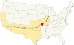
Location of Strafford on Route 66
There are clearly defined seasons in Strafford and as it is located on the northernmost part of America's humid subtropical climate, it has very wet weather in late summer.
The average summer (Jul) temperatures are: high 89°F (31.6°C) and low 68° (19.8°C); the average winter (Jan) high is 43°F (6.1°C) and low is well below freezing with 22°F (-5.3°C).
Annual rainfall is around 45.6 in. (1.160 mm), and it experiences 17 in. of snow (43 cm) yearly.
Tornado risk
Strafford is located within the infamous "Tornado Alley" and Greene County has around 9 tornado strikes per year.
Tornado Risk: read more about Tornado Risk along Route66.
Map of Route 66 through Strafford, MO
Route 66 Map and alignment
This is the map of US 66 from 1926 to 1953 in town.

Two Old Maps: USGS 1946 and (inset) 1884 of Strafford Mo.
The two maps shown in the image, show Strafford in 1884 (written "Stafford" without the first "R").
You can see that it was originally platted on the south side of the
railroad. The map also shows two roads -thin black lines. One north of town which was the road that ran next to the telegraph -which was built in 1959 and linked
St. Louis with Fort Smith in Arkansas. This road was known as the "Wire Road" it became the main road from Springfield through Strafford to Rolla (now it is State Highway DD).
There was another road from Springfield to St. Louis, shown in the map south of Strafford and it was the main road until the 1860s. The Trail of Tears migration of Indians into Oklahoma followed this road.
Later, the town moved to the north side of the railroad (built in 1870), as shown in the USGS map of 1946.
The town's main street was Pine Street and it became part of a newer highway that ran close to the tracks, from Strafford to Rolla.
By the early 1900s the use of cars increased and expanded to the countryside. The dirt tracks used by carts were unsuitable for automobiles, as they became muddy traps after it rained. There was a public demand for better roads, and John Woodruff lobbied for them with the Inter-Ozarks Highway Association he presided. Missouri State Highway 14 was built through Strafford, and improved. Later, in 1926 Route 66 would be aligned along it. Woodruff's office in Springfield was the Birthplace of Route 66.
The alignment near Strafford
Visit our pages, with old maps and plenty of information about US 66's alignments.
- Springfield to Joplin (next)
- Rolla to Springfield (Strafford's)
- Gray Summit to Rolla (previous)
Route 66 Sights in Strafford
Small Town with Two Main Streets
Historic context, the classic Route 66 in Strafford
Jack DeVere Rittenhouse described Route 66 during its "classic days" in his 1946 book "A Guide Book to Highway 66". In it he describes the town as follows.
STRAFFORD... McDowell garage; gas; no courts), a community whose peak has been passed, now only a suburb of Springfield Rittenhouse (1946)
He mentioned now gone gas stations 3 and 5 miles west of the town.
Thinking about visitingt Branson?
Some tours and sightseeing
Sponsored
Tour the route 66 landmarks in Strafford
There are almost no remains of Route 66 in Strafford. We will drive into the town from the east and head west towards Springfield.
What is now Highway OO was the 1926 to 1953 Route 66. It was replaced by a four-lane alignment (now under the freeway) in 1953. When you reach Strafford, Route 66 follows the railroad tracks westwards into the town, but the original Main Street is one block further north. Strafford is the town with Two Main Streets.
The Two Main Streets
The famous "Ripley's Believe it or Not" column, published worldwide, in the 1950s published a comment on Strafford. It was said to bet the only town in the U.S. that had two main streets and not a single alley. The fact is that its main street (Pine Street) became a secondary street when Route 66 was aligned along a vacant strip of land between the railroad and the back part of the buildings that lined Main St., thus becoming a new Main Street. The stores relocated their storefronts to face Route 66.
Go down Old Route 66 and on the block that follows Jefferson St., to your right are some classic buildings.
Old Crawford Café
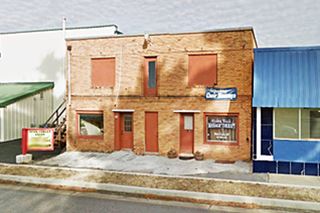
119 E. Old Rt 66. To your left. The building that once was the Crawford Café, located to the west of the old Baumgatner's Store and Service Station is still there, as you can see in the "Then and Now" images below.
Crawford cafe in Strafford MO next to Baumgatner's Store c.1940s
Former Crawford Cafe in Strafford, as it appears today
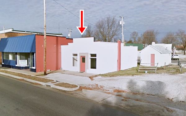
Baumgatner's Station
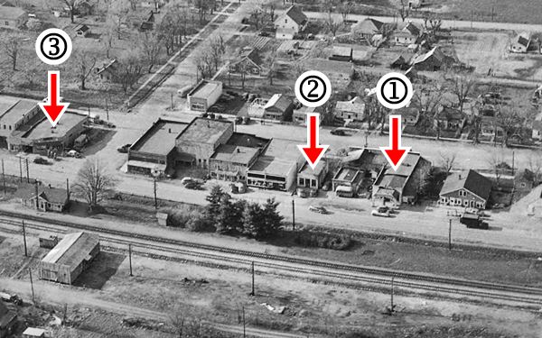
This Phillips 66 station was built in a Spanish Mission Style, with a solid canopy over the pump island. It was located to the right of the cafe, and was torn down. You can see it in the image below, an aerial photograph taken in 1952: (1) Baumgarner's Gas Station, (2) Crawford Cafe. The building marked (3) is McDowell's Garage.
Route 66 runs across the image from right (east) to left (west), Main Street can also been seen behind the buildings.
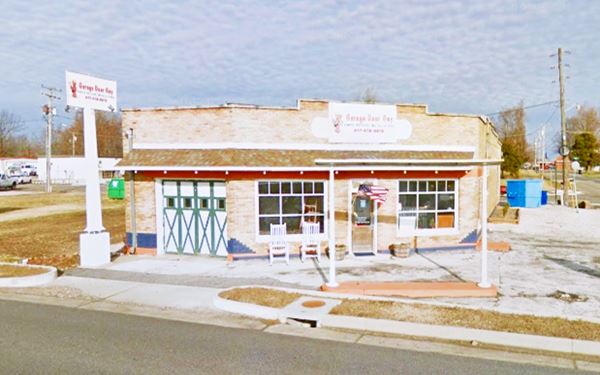
Former Crawford Cafe in Strafford, as it appears today
Baumgatner's Store and filling station was razed and now a vacant lot stands right of the former cafe. There are some old buildings left on this block.
Willis Hotel
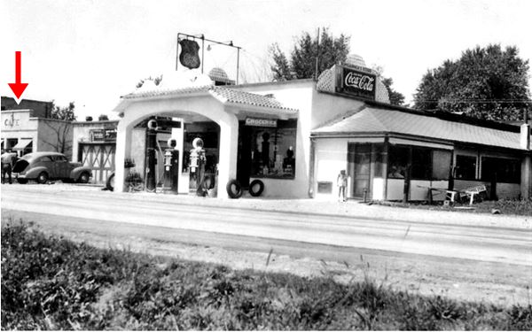
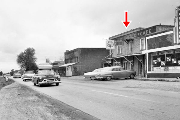
The hotel is the two story red-brick building to the left of the cafe. You can see it in the 1950s image further down.
The black and white photograph of the hotel (red arrow) shows the sign painted on its facade "Willis Hotel & Cafe." The store between the Café and the hotel was a hardware store (still standing).
It seems to have been closed by the time Rittenhouse drove by in 1946, he wrote "no courts."
McDowell's Garage
On the next corner, NW corner of Route 66 with S. Madison. Listed in the 1993 Route 66 Survey as A-I gas station. It was mentioned by Rittenhouse in 1946. It opened in 1924 and faced Main Street. Later it added a new front facing Route 66, on the corner. The aerial photograph further up shows it without a canopy and with three pumps lined up against US 66. In the photo of Willis Hotel (above) you can see a "Firestone" sign above the gas station above the car with the roof rack. At one time it was a Texaco.
Historic Delp Route 66 Park and mural
On the same block next to McDowell's, to your right, just next to the City Hall is the Historical Delp Route 66 Park.
The city of Strafford built this "Route 66 Histroical Park" to safeguard the local heritage. They have built stylized replicas of the old Baumgatner's station and the town's railway depot, a future visitors' center (See picture below.)
It will also include Delp's Hotel. There is a pavilion behind the gas station replica ideal for a picnic.
Delp's Hotel was a ten-room property that Frank Delp built in 1911. It served Route 66 travellers until it was torn down in 2008.
The park also has a Veteran's Memorial.
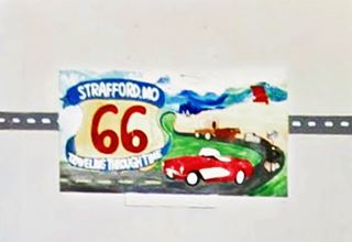
Don't miss the "Route 66 Mural" painted on the City Hall's wall facing Route 66 (pictured below).

Railway depot replica at Delp Park. Credits
Viles filling station stood on the same corner where the City Hall is now located.
On the next block westwards there were stores and a gas station. Below is the "Then and Now" sequence, 1950s and nowadays, the stores (1) and (2) are still there and so is McCabes Station, that sold Standard Oil marked (3), now closed.
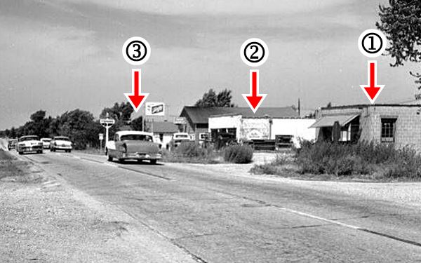
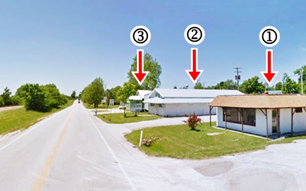
Your tour of Strafford ends here, head west to continue your Route 66 road trip in Springfield, and don't forget to visit its Bypass 66 attractions.

Some sponsored content
> > Book your Hotel in Lebanon

Credits
Banner image: Hackberry General Store, Hackberry, Arizona by Perla Eichenblat
Jack DeVere Rittenhouse, (1946). A Guide Book to Highway 66
Architectural - Historic Survey of Route 66 in Missouri and Detailed Survey, Maura Johnson. 1993


