Just a Stop on Route 66
Index to this page
About Red Top Missouri
Facts, Trivia and useful information
Elevation: 1,487 ft (454 m). Population n⁄a (2010).
Time zone: Central (CST): UTC minus 6 hours. Summer (DST) CDT (UTC-5).
Red Top is a small community on Old Route 66 in western Webster County, in southwestern Missouri. The area also includes two townships: Holman and Northview.
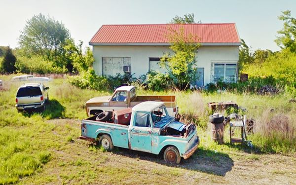
Former Red Top Garage, as it appears today
History of Red Top
Read the history of neighboring Strafford or Marshfield for full details on the region's history.
This farming community prospered as a service point along Route 66, which was built in 1926 in this area, just north of Northview (a station on the A&P railroad), east of the failed village of Holman (now defunct); between Strafford and Marshfield.
It had a cafe, cabins, garage and service station. Located at the crest of the hills that mark the divide between the Missouri River to the north and the Arkansas River to the south. Now there is a few homes, a car cluttered junkyard and a Railroad caboose.
The name: Red Top
The old garage had a red top gabled metal roof, and it was used as the place's name. The words "Red Top" were painted on it, an eye-catcher for those driving along Route 66.
The original Route 66 bypassed the town (1952) and later it became a freeway (1958), this sealed its fate.

Getting to Red Top
You can reach Red Top along historic Route 66 and Interstate I-44 that link it with Springfield to the west.
Where to Lodge in Red Top, Missouri
There are no hotels or accommodation in Red Top but you can stop nearby in Strafford
> > Book your hotel in town Strafford
More Lodging near Strafford along Route 66
There are several hotels in the area close to this town. Alternatively you can also find your accommodation along Route 66 in the neighboring towns and cities in Missouri. We list them below (from east to west):
On Route 66's Main alignment in MO
Eastwards
Westwards
- Hotels in Kansas
- Baxter Springs KS
- Galena KS
- Riverton KS
- Hotels in Oklahoma
- Miami OK
>> Check out the RV campgrounds in Strafford
Weather in Red Top
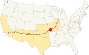
Location of Red Top on Route 66
The seasons in Red Top are well defined and as it is located on the northern limit of the U.S. humid subtropical climate. Its weather is very humid during late summer.
The average summer (Jul) temperature is the following. High 89°F (31.6°C) and low 68° (19.8°C). Winter averages (Jan) are: high 43°F (6.1°C), and a freezing low of 22°F (-5.3°C).
Annual rainfall is around 45.6 in. (1.160 mm). Snowfall is 17 in. (43 cm) per year.
Tornado risk
Red Top is located within the infamous "Tornado Alley" and Webster County has around 9 tornado strikes per year.
Tornado Risk: read more about Tornado Risk along Route 66.
Map of Route 66 through Red Top, MO
Route 66 Map and alignment
See this map of US66 in Red Top.
As you can see, it curves sharply to the south and back to the north. Rittenhouse in 1946 wrote that the local motel and service station were located at at the summit of a "one-mile, winding grade" for those coming from the east.
Route 66 followed this winding course from 1926 to 1953 when a four-lane alignment was built through this area, but it had grade crossings and intersections. It was later upgraded to the Interstate divided highway standards.
The alignment in Red Top
Visit our pages, with old maps and plenty of information about US 66's alignments.
- Springfield to Joplin (next)
- Rolla to Springfield (Red Top's)
- Gray Summit to Rolla (previous)
Route 66 Sights in Red Top
Landmarks and Places to See: Just An old Service Station
Historic context, the classic Route 66 in Red Top
Jack DeVere Rittenhouse in his book "A Guide Book to Highway 66," published in 1946 tells us what Red Top was like at that time. He states it was 8 miles east of Strafford.
at the top is Red Top tourist camp: cabins and gas Rittenhouse (1946)
He added that it was at the summit of a "one-mile, winding grade" for those coming from the east. There were gas stations, now gone, 1 and 2 mi. east of Red Top . Towards Strafford, 3 mi. west of Red Top was a now gone Oak Grove Lodge, that had cabins and gasoline.
Road Trip through Red Top
We will drive westwards coming from Marshfield. Route 66 is a narrow two-lane highway. After passing the concrete manufacturing plant (right) the road has an "S" curve. Here, to your right is the site of the long gone "Little Park Camp", which later was known as "Brown's Camp". Half a mile ahead, in the middle of another "S", to your right, is the site of "Cap's service station and store", gone.
Northview

Ivey station and Cafe, Route 66 Northview. Source
One mile west the highway curves away from the freeway and heads left. Here you begin a one-mile-long ascent and half way up you reach the crossroads that leads to the hamlet of "Northview" 0.9 miles south (left) along Co. Rd. B. "Ivey Sation and Cafe", that sold Phillips 66 gasoline was located at the intersection.
Northview had different names over the course of the years, it was originally known as "The Switch" and later as "Bunker Hill". Its post office opened in 1873 and adopted the name due to the great view it had from the top of the hill.
The highway curves north again and climbs into Red Top. There is only one surviving attraction in Red Top, the old garage.
Red Top Garage
To your left, at 16435 Old Route 66 East, Red Top. The Red Top Garage also known as "Red Top Camp".
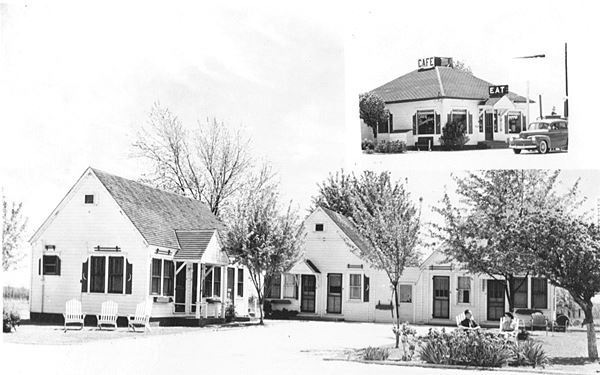
You can still see this one-story rectangular concrete block building with a two-bay garage. At one time there was a cafe and cabins (see photo below), now gone.
Rittenhouse describes it as being locatd at the crest of the Northview hill, a one-mile long winding grade. There were seven cabins here at one time.
It dates to the early 1940s when Forrest Siggins came over from Florida owned and ran the place between 1946 and 1959. Then he rented it to Austin Stewart who operated the place until the early '80s. It was then that it became a junk yard.
Postcard of Red Top Cafe and cabins in a 1946 postcard
The current owner bought it in 1986, changed the roof on the old service station and had plans to restore it some day it is pictured at the top of this page.
Otto's Steak House - Gone
The stake house stood across the road, to your right. You can see it in this aerial photo from 1955 that shows, the four-lane brand new US66 highway above, and the curve in the old 1926-53 Route 66 below with Red Top on the bottom side and Otto's between both highways.
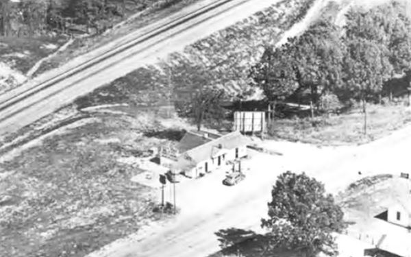
Above is a "Then" view with the four-lane US66 on the top (upper left), Otto's in the middle and the Red Top complex beneath the old US 66 (lower right).
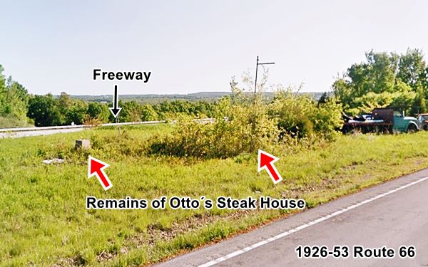
Holman
Site of Motel, Court and gas stations
Drive west, after 1.8 miles, to your right, beyond the freeway, on its north frontage road you will see an RV campground. This was the site of "Five Oaks Motel", Rainbow Court, Oak Grove Lodge and Lurvey Station. Some were torn down when the four-lane alignment was built, and others shifted north to adapt to the new highway.
As recently as 2012 some buildings survived (Street view), but now nothing remains of them, but you can see them in this aerial photo taken in 1955, above the 4-lane highway.
Just east of this spot, there are some ruins on the north side of Evergreen Road (satellite view), probably remains of one of these gas stations, you can also see it in the 1955 aerial picture.
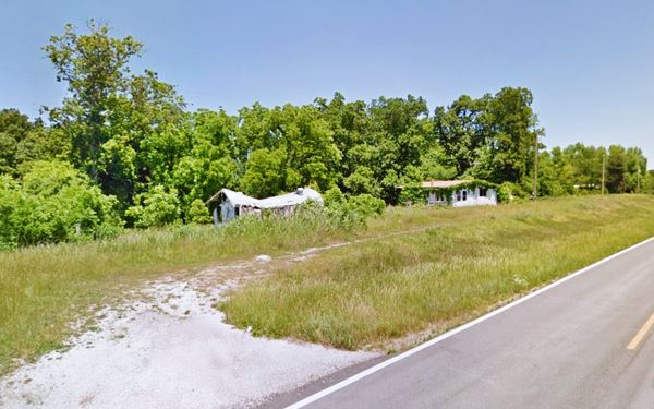
Holman had a post office that opened in 1903 and shut down in 1911. At one time there was a school here. It was named after a local settler. The community vanished.
Wild Animal Safari and Ranch Hotel
To your left, beyond the railroad tracks, this modern drive-through wild animal reserve is located on the land where the "Exotic Animal Paradise" once stood. The old "Ranch Hotel" or "Holman Ranch" with five cabins was located here, it has been torn down.
It was the site of the Holman family homestead and it was listed in Duncan Hines guide as a great place to eat at.
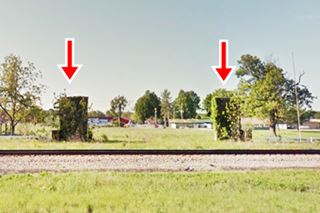
The Hotel and cabins were located close to the two stone gate pillars that are still there, to your left (red arrows in the image).
Your tour of Red Top ends here, head west to continue your Route 66 road trip in Strafford, and further west in Springfield.

Some sponsored content
> > Book your Hotel in Lebanon

Credits
Banner image: Hackberry General Store, Hackberry, Arizona by Perla Eichenblat
Jack DeVere Rittenhouse, (1946). A Guide Book to Highway 66
Architectural - Historic Survey of Route 66 in Missouri and Detailed Survey, Maura Johnson. 1993


