Index to this page
- New Mexico Route 66 Itinerary and maps
- Historic background
- Tucumcari
- Montoya
- Newkirk
- Cuervo
- Santa Rosa
Historic Route 66 Tucumcari - Santa Rosa
New Mexico Route 66 Itinerary and maps
Each leg of Route 66 described below has an interactive map and many image maps so you can follow the alignments of the highway along the way:
- Glenrio to Tucumcari - Map of this segment
- Tucumcari to Santa Rosa - Map of this segment
- Santa Rosa to Albuquerque - Map of this segment
- The Santa Fe Loop (1926-37) - Map of this segment
- Albuquerque to Lupton - Map of this segment
Arizona, next leg
Texas, previous leg
Tucumcari to Santa Rosa Historic Route 66
Starting point: Tucumcari
Route 66, Tucumcari to Santa Rosa, NM.
Listed in the National Register of Historic Places.
This is the historic segment of Route 66 from Tucumcari to Santa Rosa.
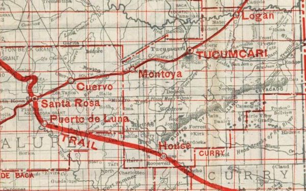
When Route 66 was created it was originally aligned along the "Ozark Trail". This "Trail" was actually a privately sponsored highway system set up in the 1910s. This section of the highway was designated in 1914 as New Mexico State Highway 3. It became Route 66 in 1926 and during the late 1920s it was improved and underwent some small realignments. The map below shows different roads that could be used by cars in 1912, called "Auto Roads" (full red lines).
National Old Trails Map Tucumcari to Santa Rosa. 1912
Ozark Trails Marker site
The Ozark Trails built one of its markers, an obelisk-like monument on the NW corner of "Second and Garnell" (Garnell is modern Route 66). Below is a picture of the monument that was later removed, read the news article published on 27 Jun 1918 in The Tucumcari News and Tucumcari Times when it was erected.
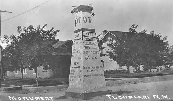
>> green line in our custom map is the 1926-85 US 66 across Tucumcari
According to the 1930 USGS map of Tucumcari, the original "Ozark Trail" left the town westwards along Tucumcari Blvd. and crossed the railroad with a grade crossing there.
Then it turned to the SW and ran along the northern side of the tracks along what is now Quay Road 62.9 This segment now ends in a dead end, but in those days it continued all the way to Bluewater Creek, where it crossed beneath the tracks by passing under the tracks to the south side (red line in custom map)
>> red line in our custom map is the 1926-32 US 66 west of Tucumcari.

Satellite View 1926 alignment.
Click image to enlarge
or here for satellite view
The Blue arrows show where it curves to pass under the tracks.
1932-56 alignment
When the highway was paved in 1932, it took the same course it has now, curving to the SW when it meets the railroad instead of crossing it. As it approached Bluewater Creek it ran closer to the tracks (see Red arrows in the image) than the modern alignment and met the older Ozark Trails alignment by the creek.
In the image you can also see the concrete abutements of the bridge that took it across the creek (red circle in image, and blue marker in our custom map). You can also see the old paved roadway running between modern US66 (Black arrows) and the tracks.
>> navy blue line in our custom map is the 1932 paved alignment out of Tucumcari
In 1950 the highway was realigned at the bridge and a new bridge was built across the creek (pink line in custom map).
>> pink line in our custom map is the 1950 realignment
The 1926 alignment continued west by the tracks, and can be driven as W Tucumcari Blvd but it ends in a dead end. There is a gap in the roadway and then it is overlaid by the freeway for the next 2.5 miles (black line in custom map), when it resurfaces south of I-40.
>> black line in our custom map is the gap west of Tucumcari
1926-67 Route 66 east of Palomas
Paved in 1932 it runs from the freeway in a deep curve south and then to the northeast passing by Palomas, a railway depot that was located 1⁄2 mile north of the highway at Quay County Rd. AZ
>> red line in our custom map is the 1926-67 Palomas alignment
You can drive its alignment south of I-40 and reach it at Exit 321. The eastern part is in private property so turn right and drive west.
New Mexico MPS State Maintained Route 66- Palomas to Montoya
Historic Segment
The stretch is 10.4 miles long. and starts at US 66 by the freeway's Exit and runs west into Montoya. It has a gap in the alignment ahead (black line in our custom map)
>> black line in our custom map is the gap in the alignment, the blue marker is the underpass.
The form listing it in the National Register of Historic Places confirms that the underpass was never part of Route 66's alignment: "Route 66 serves as a frontage road for local traffic. Except for a subway in which the road passes under Interstate 40, deviating from the historic alignment for less than a quarter mi."
The course of the modern South Frontage Rd. of I-40 passes under the freeway (using a narrow concrete underpass) crossing to its northern side. The unpaved underpass could have water during rainy days. Be careful.
Montoya
>> red line in our custom map is the Montoya segment of US66
The highway then runs along the north side of I-40 alignment straight into Montoya, a small village.
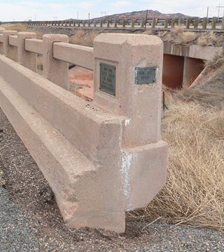
The image shows a steel stringer bridge located 1.7 miles east of Montoya, Bridge #1758, built in 1936. It is 81 ft. long and 24 ft. wide.
The historic segment ends at I-40s Exit 311 on the western side of Montoya.
Montoya to Cuervo Historic Route 66 1936-60
Route 66, Montoya, NM.
Listed in the National Register of Historic Places.
>> pale blue line in our custom map is the 1932-60 Montoya to Cuervo Alignment
This is the second historic segment of Route 66 of this leg, and it runs between Montoya and Cuervo. Paved in the 1936 and used until 1960 when the four lane 66 and I-40 was built.
Check this map with directions of the driveable alignment from Montoya to Cuervo of this historic Route 66 segment. The actual roadway was cut twice by I-40, once on the western side of Montoya (black line), and again at Riggs Ranch Rd. where an overpass across I-40 bridges the gap. The alignment is marked with a yellow line in our map.
>> black line in our custom map is the gap at Exit 311 in Western Montoya
1926-36 Route 66
The previous alignment, which was paved in the early 1930s, had a longer and winding alignment from Montoya to Newkirk; it is the violet line in our custom map. It is cut off in many parts, and can't be driven but the concrete roadway is still there in many places. It has a bridge, whose deck has gone, but the abutements have survived (violet marker in our custom map). It is cut by the freeway twice, once at Riggs Ranch Rd. and again as it approaches Newkirk.
>> violet line in our custom map is the 1926-36 Montoya to Newkirk US66. Violet marker: bridge abutements
The map below (from 1925) shows how the Auto Trails along which US66 would be aligned one year later; the road surface at that time was: "Improved Road" from Tucumcari to west of Montoya and from Santa Rosa to the junction with the road heading south from Cuervo (black and white dashed line), then "Dirt Road" for the rest of the segment (solid white line).
Vintage Road map, Tucumcari to Santa Rosa. 1925
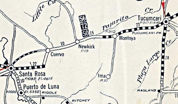
The Federal government funded improvements in Route 66 under FAP 114, and in 1936 the current "Historic alignment" was paved with a hard surface.
Newkirk
The 1926 and the 1936 alignments meet on the eastern side of the small rural community of Newkirk.
West of the town, the paved 1936-60s alignment runs along the north side of I-40 west of Newkirk.
Dirt 1926 Alignment near Newkirk (?)
There is an interesting set of maps and a post about the possible original alignment of the 1926 dirt surfaced Route 66 that was later abandoned when a straighter road was built and paved. It went south, towards Newkirk's cemetery and then west. See the maps and read the article.
Later 1930s alignment to Cuervo
The highway runs towards the next town, Cuervo (Cuervo is the Spanish word for "crow").
>> pale blue line in our custom map is the segment into Cuervo.
Gas station in ruins, Cuervo
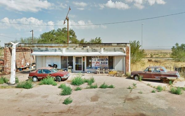
Final leg into Santa Rosa
The highway ran along the North Frontage Rd. and Cuervo's block on the south side of it was razed to make space for the freeway in the 1960s. On the west side of Cuervo, there is a fork in the alignment: three different ones split here in Cuervo over the course of the years. We describe them below.
1. 1926-32 Alignment
>> bordeaux line in our custom map is the 1926-32 Cuervo to Santa Rosa US66 (1st part
From this intersection, the first (1926) alignment went straight southwards for 5.4 miles and then took a 90° turn to the west along modern Highway 156 for 4-5 miles (Map with directions). The 1932-56 alignment met it here.
Both alignments 1926-32 and 1932-52 ran together (yellow line) to another fork:
>> yellow line in our custom map is the 1926-52 alignment towards Santa Rosa
1. 1926-32 Route 66 splits from the alignment, and turns towards the SW and then westwards all the way to modern US 84. This segment (red line) is a trail, dirt surfaced, rough road and can't be driven. There is a culver along the alignment (red marker).
>> red line in our custom map is the 1926-32 US 66 into Santa Rosa
Here the highway continued west, now overlaid by the airport's runway (pale blue line), so it can't be driven.
>> pale blue line in our custom map is the 1926-32 US 66 Airport segment (can't be driven)
West of this point it can be driven (pink line in custom map).
>> pink line in our custom map is the 1926-32 US 66 into Santa Rosa.
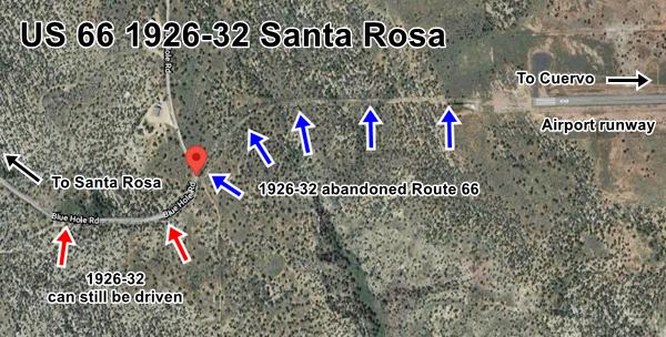
The satellite view below shows the abandoned segment west of the runway (Blue arrows) and the driveable segment, (Red arrows).

1926-32 Alignments into Santa Rosa
The image map above, shows the airport marked with a red star in the center of the map. The map also shows the 1926-32 alignment with a black dashed line (- - - ) and Blue arrows.
After the airport the higway entered Santa Rosa from the Southeast, along modern Blue Hole Rd, Lake Drive and then S 4th St. into downtown Santa Rosa. See the Map with directions of the final part of 1926 - 1932 Route 66 into Santa Rosa.
2. 1932-52 Alignment westwards into Santa Rosa, but first let's describe this historic alignment, and then its final segment:
Historic Route 66 Cuervo to Santa Rosa (1932-52)
Route 66, Santa Rosa, NM.
Listed in the National Register of Historic Places.
This is the historic segment of Route 66 from Cuervo to Santa Rosa.
It has a gap at its beginning wher I-40 disturbed its roadbed (black line) then it took a NE-SW course along Co. Rd. 2C.
>> black line in our custom map is the gap in Cuervo of the 1932-56 US66
The old 1932 Route 66 west of Cuervo
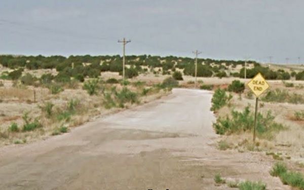
The 1932-52 alignment climbs to an elevation of 5,100 ft. at Mesita Contadero crossing rangeland with cholla cacti and short tough grass.
The road ran straight, there is a bridge on the alignment (green marker).
According to the
Historic Places record, there was a gas station at the summit of this climb "a spot now marked only by the buildings foundations and concrete pump
island (see Satellite view of this spot).
Then it reached NM highway 156 (NM-156) where it met the 1926-32 alignment, and curved to the right, heading west. In 1952 it was realigned along the course presently followed by 1-40. This section was abandoned and is not upkept.
A Word of Caution
These roads west of Cuervo are rough dirt surfaced trails and they have washouts and potholes. They are not paved. You should have a vehicle with high clearance to drive them. Local ranchers still use it. Check with the locals before driving them. Check before trying to drive these segments.
At the fork mentioned above, where the 1926-32 US 66 turns to the SW, the 1932-52 highway continues straight with a westerly course all the way to I-40.
>> yellow line in our custom map is the 1932-52 US66 into Santa Rosa
Below is a map (1939) showing the alignment from 1932 to 1952 into Santa Rosa.
Route 66 Map Tucumcari to Santa Rosa in 1939
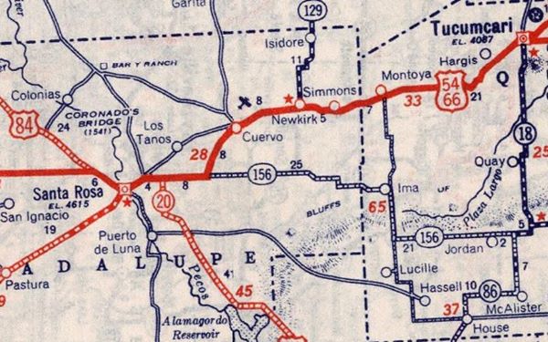
At the freeway the alignment is cut, now it uses Exit 277 to cross it, at one time it ran straight (black line in map).
>> black line in our custom map is the gap at I-40
From here it ran straight into the downtown area (orange line).
>> orange line in our custom map is the final leg into Santa Rosa
1950s to 1985 Cuervo to Santa Rosa alignment
These old alignments were bypassed by a shorter and straigter one in the 1950s. At that time, Route 66 had only two lanes and they ran where the westbound I-40 lanes now run, from Cuervo to Santa Rosa, it entered the town along the 1930s alignment. I-40 with four-lanes was built in the 70s before US 66 was delisted in 1985.
>> dark blue line in our custom map is the 1950s to 85 Cuervo - Santa Rosa US66
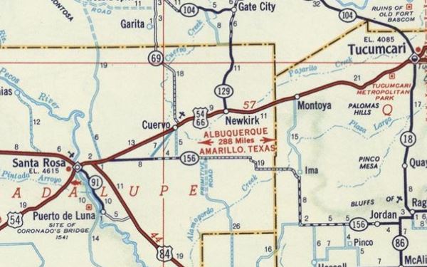
Below is a 1956 Shell roadmap in which you can see this section (and the former ones too).
Route 66 Map Tucumcari to Santa Rosa in 1956

End of this leg of your journey
Santa Rosa
Downtown Santa Rosa is the end of this leg of your Route 66 Road Trip from Tucumcari.
Next Section
Santa Rosa to Albuquerque
The Santa Fe Loop (1926-37) splits from this alignment.
Previous Section

Some sponsored content
> > Book your Hotel in Santa Rosa

Credits
Banner image: Hackberry General Store, Hackberry, California by Perla Eichenblat
Jack DeVere Rittenhouse, (1946). A Guide Book to Highway 66


