The Gateway to New Mexico
The Palomino Motel
Index to this page
About Tucumcari, New Mexico
Facts, Trivia and useful information
Elevation: 4,091 ft (1,247 m). Population: 5,031 (2025).
Time zone: Mountain (MST): UTC minus 7 hours. Summer (DST) MDT (UTC-6).
Tucumcari is the largest town along Route 66 between Amarillo and Albuquerque. It is the seat of Quay County.
Eastern New Mexico has been inhabited for at least 11,000 years, as proved by stone tools found at the nearby Clovis site. The area was explored by the Spanish, who introduced the horse (1500s) which the local Querecho Apaches adopted. By the mid-1800s, (when Mexico ceded the area to the U.S. after defeat in the Mexican American War of 1846-48), the Kiowa and Kiowa Apache together with the Comanche dominated the region and fought with the U.S. Army and white settlers until subdued in the mid 1870s.
Soon cattle ranches were established in the region. The first settlement in the area was a village named Liberty, north of Tucumcari, north of Pajarito Creek and close to Liberty Mesa, established in 1882. Bandit Tom "Black Jack" Ketchum robbed the post office there in 1896. But Liberty dissolved when the railway was routed further south a few years later.
When the CRI&G Railroad (Chicago, Rock Island and Gulf Railroad) extended its tracks westwards from Texas into New Mexico, it set up a siding in 1901 named "Ragtown" or "Six Shooter Siding" at what is now Tucumcari. The construction camp grew into a town on land deeded by former Liberty businessmen Goldenberg, Wertheim, Street, and Smith.
The town was initially named Douglas (1901-1902) but soon after it was renamed with its current name: Tucumcari. The post office was established in 1902. The town was named after Tucumcari Mountain that is 3 miles south of it.
The name Tucumcari
The legend of doubtful authenticity goes as follows: The local Apache Chief Wautonomah decided to choose his successor through a fight to death between two young braves, Tonopah and Tocom. Unknown to the Chief, his daughter Kari was in love with Tocom. The two men fought with knives in a mortal duel and Tocom was stabbed in the heart. Kari who was watching the scene, rushed forth and used a knife to kill Tonopah and then kill herself.
The Chief, heartbroken cried out aloud "Tocom-Kari" as he too stabbed his own heart with the same knife.
A more likely explanation for the origin of the name Tucumcari can be found in the diary of Spanish explorer Pedro Vial who wrote about his round-trip journey from Santa Fe to Sain Louis during November 1793. On his way back he wrote that "to the south, leaving the river on the right hand I made out Tuconcari."
A clear indication that Tucumcari Mountain had a native name back in 1793.
A 1777 record for the area tells of a Comanche woman and child captured at the battle of "Cuchuncari".
The word is probably the corruption of a Comanche word that means "lookout" (Tukamukaru), appropriate for a mountain in a relatively flat area.
Tucumcari Mountain
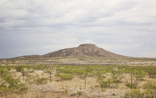
Tucumcari Mountain is 4,677 ft. high (1,515 m) high. So it is about 900 feet (275 m) higher than the surrounding area. It is not the highest peak in the area as Mesa Redonda, further south is higher. But, it is very visible and shaped like a mesa on top of a mesa (see image below).
Its rocks are Cretaceous, Jurassic and older; the fossil of an extinct oyster (Gryphaea tucumcari) was named after it. The sediments are light colored clay shales.
The locals have whitewashed boulders on the hill to form a letter "T" on the mountain. The movie "Cars" has a similar hill with the initials "RS" (after Radiator Springs).
The county was created on Jan. 28, 1903 and named after Matthew S. Quay, (1833-1904), US Senator from Pennsylvania and Tucumcari became county seat.
It was a cattle breeding community which received many homesteaders who settled in the area. Route 66 was aligned through the town in 1926 bringing more prosperity as the locals catered to the travellers. In 1940 the South Canadian River was dammed providing water for irrigation, and farming boomed.
Tucumcari Movie Trivia
The character Raymond played by Tom Cruise mentions Tucumcari in the 1988 film "Rain Man."

Find your Hotel in Tucumcari
Book your hotel in Tucumcari. There are plenty of motels and hotels in town
> > Book your Hotel in town: Tucumcari
Lodging Near Tucumcari along Route 66
Below you will find a list of some of the towns along Route 66 in New Mexico. Click on any of the links to find your hotel, motel or accommodation in these towns (listed from east to west):
On Route 66's Main alignment
The Santa Fe Route 66 segment
Eastwards
Westwards
>> There are RV campgrounds close to Tucumcari.
The weather in Tucumcari
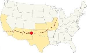
Location of Tucumcari on Route 66
This region is semiarid and the yearly rainfall is around 16.1 inches (409 mm). Summers are hot but with lower temperature during the night which make them bearable winters are cool. There are 40 days per year with precipitation, and most of it takes place mostly during the summer, when the North American monsoon provokes intense downpours. From May to August 9.4 in. fall (239 mm).
Snowfall is quite light; on average, 8.2 inches of snow falls (21 cm) and can take place at any time between September and May. There are 266 sunny days per year and the highest high temperature recorded was 109 °F (43 °C) on June 28, 1968 while the lowest was -19 °F (-28 °C) on January 13, 1963.
Average high in summer (July) is 93°F (34°C), and in winter (Jan) is 53°F (12°C). The average summer low is 64°F (18°C) and the winter low is 23°F (-5°C).
Tornado risk
Tucumcari is located in an area with a very low risk, as it only has three (3) Tornado watches every year. Tornado Risk: read more about Tornado Risk along Route66.
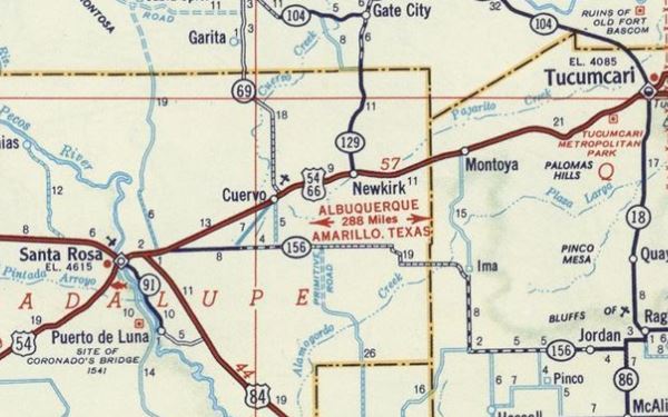
Map of Route 66 through Tucumcari
Read the Detailed Description of this segment (Glenrio to Tucumcari and Tucumcari to Santa Rosa). Below are the interactive maps:
>> Custom map of Route 66 east of town
>> Custom map of Route 66 west of town.
See this Map of "classic" Route 66 through Tucumcari.
You can also visit our Route 66 Map of New Mexico webpage which has all the alignments of US Hwy 66 across NM and the towns along it.
Route 66 Map east of Tucumcari in 1939
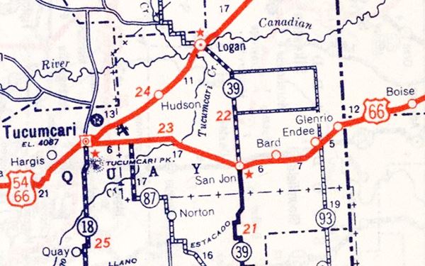
Glenrio to Santa Rosa Historic Route 66
Route 66, Montoya, NM.
Listed in the National Register of Historic Places.
The segment of Route 66 that runs through Tucumcari is a historic landmark listed in the National Register of Historic Places goes from Glenrio to San Jon.
We have two webpages that describe this historic alignment with maps and plenty details; vist our Glenrio to Tucumcari and Tucumcari to Santa Rosa Historic Route 66 webpages.
Route 66 Map Glenrio to Tucumcari in 1956
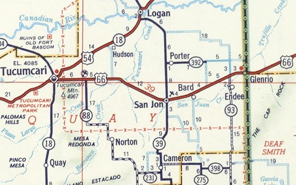
Route 66 Map Tucumcari to Santa Rosa in 1956
Sights and Attractions in Tucumcari
- Eastern Tucumcari (this page, read on below)
And on our second page:
Jack Rittenhouse drove along Route 66 in 1946, collecting information which he included in his book "A Guide Book to Highway 66", he mentioned the following regarding Tucumcari.
...hotels: Randle, Elk, Vorenberg and Davis; Courts include; Lin's, Travelers, LaNora, Star, White Cottage, Grande, Blue Swallow, Tocom-Kari, Comanche and Venetian; stores; cafes; all accommodations Rittenhouse (1946)
Tucumcari's Route 66 Attractions

Whiting Bros sign (gone).
This is a 6 mile drive east to west through Tucumcari, from Exit 335 to Exit 329 of I-40. As you enter Tucumcari from the east, on your right was a sign of a Whiting Brothers gas station:
Whiting Brothers Sign: Gone
4001 E Tucumcari Blvd.
It was located in eastern Tucumcari, on the north side of US66, just past the Super 8 Motel. It was demolished, but its signs had survived until around 2015 (2015 view), but now it has been completely razed (2018 view).
Read all about Whiting Bros. & Route 66
1960s Shell
Across from the now vanished sign is a Ranch style Shell gas station. This style was introduced in 1957. It has a low sloping gable roof with brick finish and a chimney-like extension rising from the roof where the logo was displayed. Now it is a curio shop.
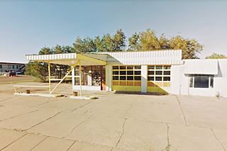
Old Gulf Filling Station
Half a mile west, at 2820 E. Tucumcari Blvd. is another old gas station to your left, on the south side of the highway. It has a flat top canopy, and glass panes on office and garage bays. The now faded bands on canopy, garage and office, the glass door in the service bays and the right angled canopy corners were typical of Gulf stations. It is pictured above.
Two historic Markers
Just ahead, to your right, on the shoulder you will see two historic markers, one tells about Tucumcari Mountain which you can see it to your left: "has long been a landmark for travelers along the Canadian River. Pedro Vial mentioned it in 1793, while opening a trail between Santa Fe and St. Louis. In order to find the best route from Arkansas to California, Capt. Randolph B. Marcy led an expedition past here in 1849".
The other marker is about the town of Tucumcari: "This area was troubled by both Comanches and Comancheros, New Mexicans who traded illegally with the Indians, until the military campaigns of 1874. With the coming of
the railroad in 1898, Liberty, eight miles to the north, moved here to form the nucleus of Tucumcari, (incorporated in 1908). The Rock Island-Southern Pacific
Depot built in 1927 is an outstanding example of Mission Revival style depot and recently restored".
This is their St. view.
Pony Soldier Motel
Ahead, on the NW corner of Tucumcari Blvd. and S. Mountain Rd. (Byp 54) once stood the Pony Soldier Motel, until 2015 its neon sign survived on the corner, but it too has gone. Only the two steel stumps of the posts that held it up have survived.
The image shows what the now gone neon sign looked like. It was removed by the owners of the motel property, the Whittingtons.
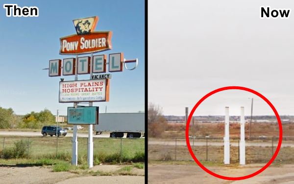
See these two St. views Before, and After it was removed.
Just ahead, also on the north side of the road (right) is a Former Gas Station:
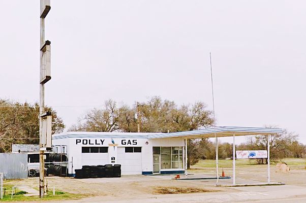
Polly Gas Station, actually Jim's #1 Texaco
1823 E. Tucumcari Blvd. This station, despite its renovated decor was not as the parrot sign indicates, a Polly station. Instead, it was Jim's Texaco No. 1 station. Jim owned two Texaco servic stations in Tucumcari, the other (Jim's #2 Texaco) was located on the other side of town, at 924 W. Route 66.
This station was abandoned, and a group of volunteers funded by the local Chamber of Commerce restored it. They chose to make it a Polly station, instead of a Texaco like it originally was. "Polly" was a gasoline brand owned by Wilshire Oil Co., which was based in Los Angeles and sold gasoline in
southern California between 1914 and 1960. The company was acquired that year by Gulf and Wilshire brand disappeared in the mid 1960s.
The "Texaco" sign, instead of being horizontal was vertical (left side of the image) with six now empty squares where the letters once stood.
Former Johnson's Enco Gas Station
Next to "Polly" is another service station restored by the same team in 2011, and it was also made into a different brand than the one it originally sold. The "Old Garage" depicted as
a Phillips 66 was really an Enco station.
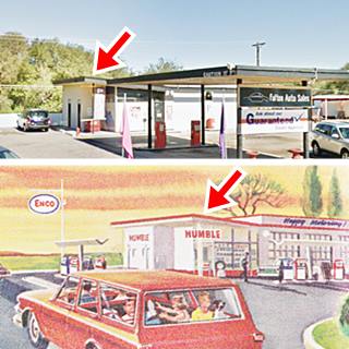
Enco brand used this modern design in the 1960s. It had a distinct inward slanted roof over the office (red arrow). This was Johnson's Enco Service at 1626 E Tucumcari Blvd.
It has a two-part layout with a flat roofed canopy over a two gas pump islands (with vintage gas pumps) and a two-bay garage higher than the slant roofed office.
Across the street from "Pollys", to your left is the Tucumcari Inn.
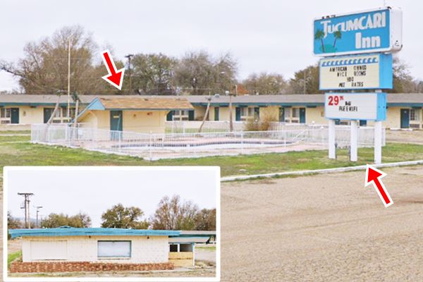
Aruba Motel - Tucumcari Inn
At 1700 E. Tucumcari Blvd. The Aruba Motel & Tiki Restaurant is now the Tucumcari Inn Motel. It opened in the early 1960s and its postcard tells us that it had "Twenty-eight tastefully appointed unusually well maintained rooms, combination tubs and showers; central refrigeration and hot water heat; room phones; cable tv, and heated swimming pool. Distinctively different "TIKI" Restaurant."
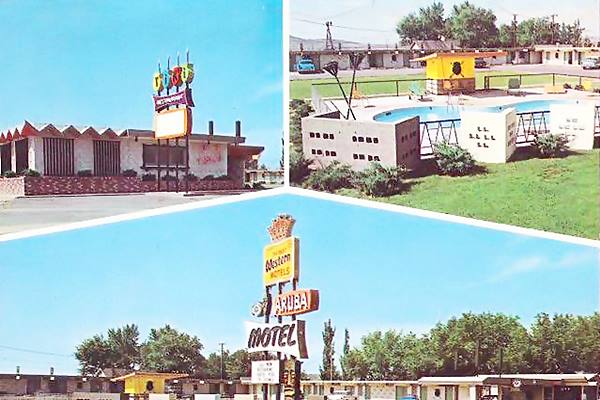
As you can see in the "Now" image below, the three steel columns of the original sign are there, and also the kidney shaped pool amd the pool house (red arrows). The roofs have changed: gables now instead of the 1960s flat roof, and the Tiki Bar on the left side of the property is standing, but boarded up (inset).
Royal Palacio Motel
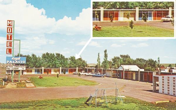
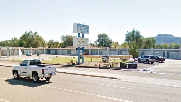
Next door, facing the former Enco station, at 1607 E Tucumcari Blvd. is another old motel. The Royal Palacio Motel which is now the Route 66 Motel. According to the postcard, it had "25 Ultra Modern Units... tile baths and shower combinations... Room phones... Cable T.V.... Fireproof... Mobile Travel Guide."
Its colorful modernistic 1960s design can still be recognized in the current building (red arrows and inset). Though the neon sign has changed considerably the aeroplanes add a nice touch to its decor.
Adjacent to the Motel is "Wailes Park" with its "Comanche Territory marker" that reads "By 1700 the Comanches had acquired the horse and began moving into this area. They drove out the Jicarilla Apaches, and their raids on New Mexico's eastern frontier posed a threat to Indian, Spanish and Anglo settlements for over a century. The Comanches were finally defeated by the U.S. Army in 1874." (St. view). There is an identical marker on the western side of town.
Atex Deep Rock filling station
Opposite the park (1501 E Route 66) you will spot an old gas station with a long one story building, no canopy. The contours of its three pump islands are clearly marked in the parking area. It was Atex Deep Rock, and it offered "Road Service". In the 1920s Deep Rock was an "independent" company that was owned 100% by Standard Oil, it wen bankrupt in the 1930s and by the 1950s it was acquired by Kerr-McGee.
McMurphy's Mobil
Just across S. Date St., on the NW corner is a former Mobil station (1421 E Route 66). It was originally operated by George Hair, who later sold it to Mickey McMurphy. The images below show it "then and now". It is currently a warehouse of Kerr McGee (an oil & gas exploration company). The concrete pump islands are still there, but the canopy has gone. A two-bay garage is now the warehouse and there and the tall neon sign posts are still there.

McMurphy's Mobil ca.1960, US 66. Source
Kiva Kort Motel
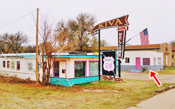
Across Route, 66, to your left is the iconic Kiva Kort Motel at 1482 E Tucumcari Blvd. The Kiva Kort Motel at one time was known as the "Mesa Court" as you can see in the image below; per this postcard (notice the same parapet crowning the units and the curved glass-brick wall marked with the red arrow). Now it is an RV camp. Its neon sign reads "Kiva A OK Welcome".
The postcard stated: "30 Air conditioned Units - Panel Ray Heat... Family Units & Some Kitchenettes - The Best for Less- Beth Haag Mgr. E.W. Bowen, Owner".

Old postcard of the Kiva Kort Motel, Source

Old postcard Mesa Court, Source
Pats 66 station
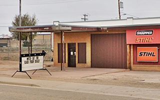
Head west, at 1301 E Route 66, to your right you will spot Dickinson Implement store, a long one story building that was "Pat's 66 Service Station" and also "Holman's Phillips 66" in the mid 1970s.
Cactus Motor Lodge
Listed in the National Register of Historic Places.
Across the street from Pat's a Historic Motor Lodge, at 1316 East Route 66 Blvd. The Cactus Motor Lodge is now an RV campground.
It was built in 1941 by I.E. and and Edna Perry in a Pueblo Revival design with stucco plastered walls. They sold it to Norm Wegner in 1952. Wegner modernized it by adding Perma-stone to its outer walls and a dance hall.
When he retired in 1972 he sold it to Harry and Jean. Its current owners Indrajit (Andy) and Sugandhi Patel bought it in 1979. Its courtyard has been converted into an RV Park and the units are long-term apartments. The great 1950s neon sign was sold and removed to a new location, and the Patels sold it to O'Reilly Auto Parts, of Springfield, Missouri, who tore it down (2021).
It was "U" shaped and had 25 units. It was located on the eastern tip of the town and was the first that westbound travellers would find when they reached Tucumcari.
The building on the northeast corner was originally a dance hall but the local myth says that people gambled in the basement and that it had a tunnel with an outside exit in case of a police raid.
The postcard shown below, had the following text printed the back of the card: "Duncan Hines and AAA Recommended Located at the East Entrance of TUCUMCARI, NEW MEXICO on Hiway 66 Tile tub and shower baths, each with individual heating unit. Double insulated walls. Carpeted floors. Steam heat. Enclosed and locked garages. Free radios, Phone 600 Member Best Western Motels Mrs. I E Perry, Owner".
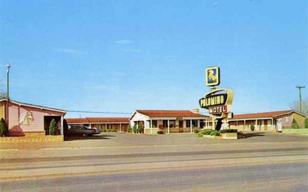
Palomino Motel
On the north side of Route 66, passing Pat's station, to you right, at 1215 E Tucumcari Blvd. you will see a classic US 66 motel.
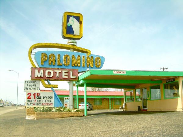
The Palomino Motel, whose fantastic neon sign is pictured at the top of this page, is still open and operating as a Route 66 motel.
Its name, "Palomino" is that of a coat color in horses: a gold coat and white mane and tail. That is why there is a horse head in the neon sign.
Its 1966 postcard shown below, says "Luxury For Less. Air Conditioned. Family Connecting Suites & Twin Beds - Free T-V. - Owners and Operators Bill & Velma Jackson".
Restored Guy's Texaco (Teague)
Next to Palomino, at 1201 E Tucumcari Blvd. Is a neatly restored gas station. Now it is a jewelery, collectibles and antiques shop painted with the word "Texaco". It has vintage gas pumps on its islands. It was Guy's Texaco station and later Card's Texaco, the current appearance doesn't fit in with the brand's style (designed by Teague in the mid-1930s) because the gabled roof was a later addition, in the 1962 picture below it has the classic flat canopy topped by the brand name.
>> Learn all about the Teague-style Texaco service stations along Route 66

1962 photo Guy's Texaco. Source
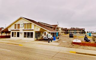
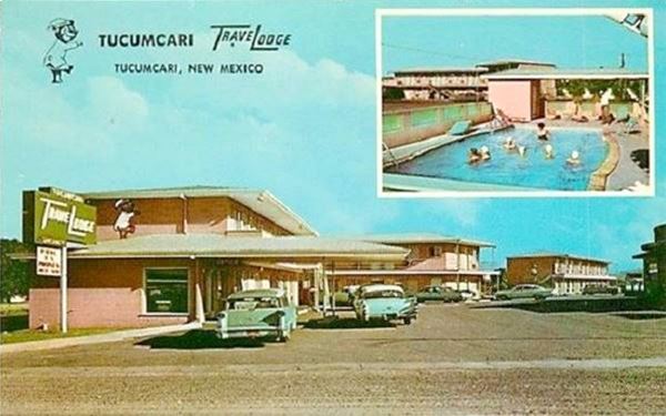
Tucumcari Travelodge
Facing the Texaco across Route 65 (1214 E. Tucumcari Blvd.) Is the old Tucumcari Travelodge; it had 39 roos, including "T.V., heated pool, phones, baby cribs, good restaurant on premises..."
Below is the Tucumcari Travelodge in a classic 1950s postcard and also its current appearance. It lost the long canopy roof at the office area and the TraveLodge neon sign, but the layout remains unchanged (the sleepy bear painted
on the wall above the office has also been painted over.
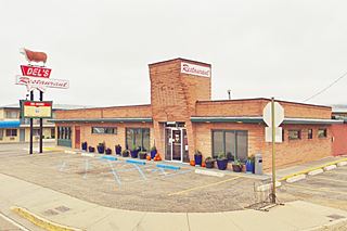
Del’s Restaurant
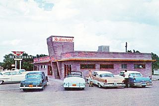
It was "on premises" as indicated by the Travelodge postcard (1202 E Tucumcari Blvd.) it was right beside the motel.
Its 1958 postcard says: "Open 5 till 9 every day. Full cours diners or luncheons - Gift Shop - Cocktail Lounge".
It has not changed much, but the neon sign has added a large steer on its tip, a typical "kitsch" Route 66 neon sign! (the Albuquerque
Mac's La Sierra also has a steer on its sign).
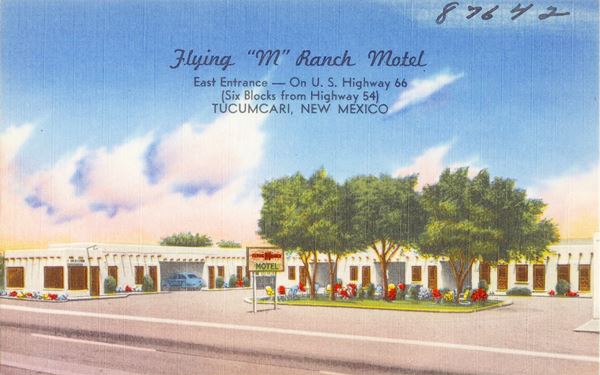
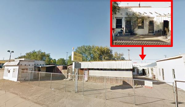
Flying M Ranch Motel
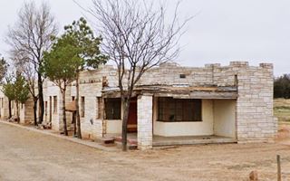
On the NW corner of Lake and Route 66, opposite Del's. This motel is now a abandoned antiques place (Ann's Corner). The U-shaped layout is visible and the pueblo-style building too, with its "vigas" (rough wooden beams jutting out of the facade).
The 1950's postcard tells us "Flying "M" Ranch Motel ... COURTESY ** COMFORT ** ECONOMY A Modern Motel with Tiled Baths. Air Conditioned and Individual Thermostat controlled floor furnaces. Green Shady Patio for New Mexico's delightful evenings. Bennie and Lorene Moore Owners & Operators".
Mayberry's Chevron Station
Next to the old Flying M Motel, at 1101 E Rte. 66. This was a Chevron, it has two service bays with multiple window doors, a flat canopy, modern plate glass office, and one concrete pump island.
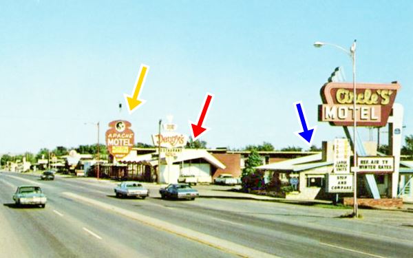
Across Route 66, on its south side (left) are the Apache Motel and a former Denny's Diner.
Fort Apache Motel
1162 E Tucumcari Blvd. Don't miss its classic neon sign. Its postcard announced "The Fort Apache Motor Hotel "Distinctively Different" On East Highway 66".
The 1950s image shows the neon sign (shaped like an arrowhead) and the walls of the motel painted with Kokopelli, a fertility god of the Southwestern Natives, a long haired humpback man playing the flute. The current sign has the face of a young
damsel (an Apache woman perhaps?).
The motel is boarded up and closed.

Apache Motel sign lit up in the 1950s. Source

Apache Motel sign nowadays. Source. Click for St. view
Denny’s Tucumcari Diner
Next to the motel is a former Denny's Diner at 1102 E Tucumcari Blvd.
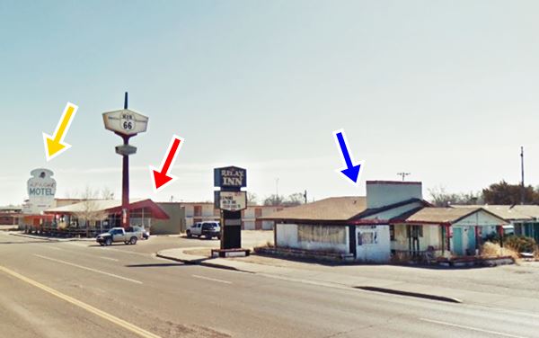
It has the classic "Boomerang Roof" designed by Armet & Davis in the ealry 1960s with the diamond neon sign, this one is now "Kix on 66", and it has raised its neon sign well above its original height.
It is pictured below in an early 1960s postcard (Red Arrow) after the Aztec Motel with its Kokopelli logo (Yellow arrow). The Double S motel on the following block is marked with a Blue arrow.
Below is the same view nowadays.
Circle S Motel
1074 E. Tucumcari Blvd. Following "Denny's", on the SW corner of S. Grover and East Route 66, is the former Circle S Motel. The building is now in ruins and overgrown, with a Relax Inn sign. At one time it was a bustling business. Its fantastic neon sign (pictured below) has gone and all that remains is the main building on Route 66 and some units along Grover St.
Golden Dragon (1966) - Hall's (1950s)
Next to Circle S, at 1006 E Route 66. It has been in business since 1966 with the same Chinese classic neon sign. Before it had been Hall's Restaurant (American and Mexican foods) that opened in the early 1950s. The original Hall's Restaurant neon sign was adapted and a dragon together with the "Golden Dragon name and the Chinese characters (金龍) under it.

1960s photo Golden Dragon. Source. Click for St. view

1950s photo Hall's Restaurant. Source.
Leatherwood Manor Motel
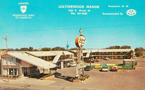
Facing them, across Route 66, on the NW corner of N Grover and Route 66 is the former "Leatherwood Motel". At 1023 E. Tucumcari Blvd.
The old "Leatherwood Manor Motel" is now the "Roadrunner Lodge". It was built by Agnes Leatherwood in 1964. It had an amazing neon sign, now gone. Its gabled roofs have survived but its "Heated pool" has been filled in.
According its postcards it was owned and ran by Arnold and Frances Olsen, and "Overlooking Tucumcari Mountain on busy Hiway 66. Luxurious, Unique and Spacious...".
La Plaza Court Motel
Adjacent to the Roadrunner (1001 E Route 66) is the old La Plaza Court motel, built in 1947. It had been closed for a long time and was recently restored by the owner of the Roadrunner.
The old motel's
postcard tells us it had "15 units overlooking beautiful Mt. Tucumcari... radios and garages". Its original layout (see postcard c.1940) had a Spanish mission-style with roofed garages between the units.

Tee-Pee Curios neon sign, Source. Click for St. view
Teepee Curio Shop
990 E. Tucumcari Blvd.
This unusual building with a teepee as a vestibule is a real eye catcher!
It started out in 1944 as a Gulf gas station owned by Leland Hayes (photo). He added "groceries, meats, curios" to his business after WWII ended. In 1959 it became
Jene Klaverweiden's Texaco service station, and it became a full-fledged curio shop when US 66 was widened through the town removing the gas pumps. Jene added
the Indian Tee-pee repurposing the old station. He also installed the great neon sign that is still standing.
The Tee Pee (Jene's Trading Post) offered rugs, souvenirs, moccasins and Indian Jewelry.
By the way, the local Navajo natives did not use teepees, they lived in houses built with stone or timber, called hogan. The conical teepee tents were used byt the natives of the Great Plains; the word "tipi" means "dwelling" in Lakota language (Thípi).

The old canopy was removed, and the garage on the right became the window with the central access and window becoming part of the teepee:

Meadows Restaurant
Next door was the Meadows Restaurant, 912 East Route 66, owned by Dora and Phil Meadows. Below is a "Then and Now" set of pictures; neon sign gone, but building still there.

1950s photo Meadows Restaurant. Source.
McDonald's Chevron
Meadows is followed by Al's, also known as Harold McDonald's Chevron Station on the next corner (902 E Tucumcari Blvd), specialized in "Major & Minor Tune Ups" in the 1971 Telephone directory. It has been altered, the canopy area has been enclosed, but the two corner service bays can be made out. See its St. view.
Town House Motel
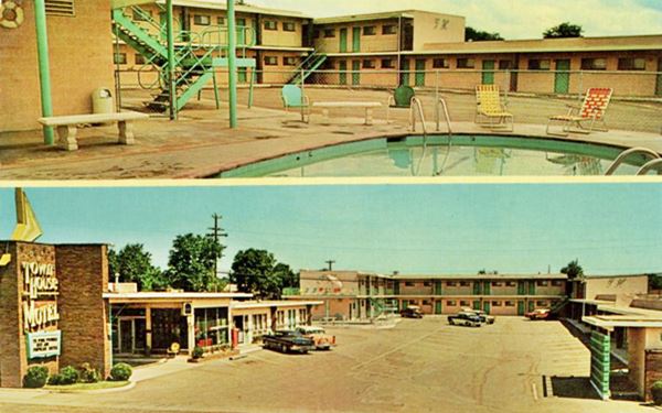
Across the street, to your right, on the north side of US 66 (919 E. Tucumcari Blvd) is the former "Town House Motel".
It began as the "Rainbow's End Court", whose advertisements said: "Look for the pot of gold in rest-in comfort. Mr. and Mrs. Howard Barnard and Son."
Later it became the "Town House Motel", owned and managed by Mr. and Mrs. Robert Barnard. Its postcard stated: "Town House Motel... offers accommodations & comfort found only in the finer motels... Swimming Pool... T.V.... Phones..."
The "arrow" on the brick structure is still there, but the buildings on the left and right now have gabled roofs.
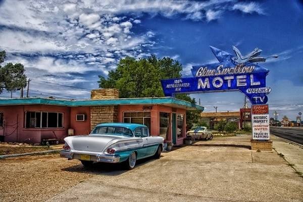
Blue Swallow Motel

Original neon sign, Blue Swallow c.1950. Source
Listed in the National Register of Historic Places.
815 East Route 66 Blvd, on the NW corner with Choctaw St., to your right. This is an iconic Vintage 1940s Motel with a great neon sign.
The swallow symbolized safe homecoming to sailors, hence its name.
The motel was built by W. A. Huggins, a carpenter, just before the beginning of World War II, it opened in 1942 and was operated by Ted Jones, a local rancher; it was the
"Blue Swallow Court"
After Jones and his wife died in the 1950s, it passed to Lillian Redman and her husband. They upgraded the neon sign, which is still there.
Lillian became a part of Route 66's folkore; she once said: "I end up traveling the highway in my heart with whoever stops here for the night."
Mrs. Redman sold the Blue Swallow in the late 1990s, and it is still open after being partially restored in 2007 within the Route 66 Corridor Preservation Program.
Facing the Blue Swallow, on the SW corner, stands the old "Tucumcari Café" with its curved glass-brick corner window. Ahead, at the end of the block was the "Grande Courts".
Grande Courts
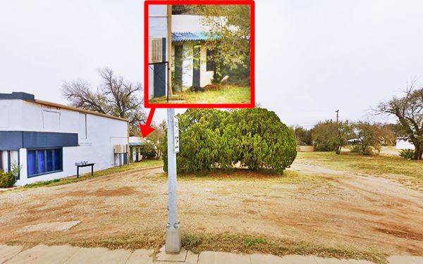
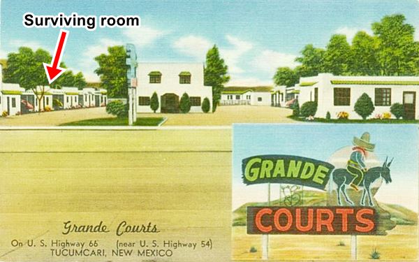
On the SE corner of S Dawson and Route 66, now an empty lot, once stood the "Grande Courts", its postcard tells us it had "Tiled Baths - Panel Ray Heat - Some Kitchenettes - Near Good Cafes, Filling Stations, Drug Store, Curio Shop and Grocery Stores - A Good Clean Place to Stay at a Price You Can Afford."
It dated back to the 1940s, and was torn down ca.2000. But a small part of the old motel has survived, on the eastern side of the property, behind the two story building that faces E Tucumcari Blvd., which in the 1940s
was a café you can see one remaining unit.
Notice how it has the same white stucco walls with a narrow green Spanish-tile awning over the windows and door that you can see in the postcard below.
Johnny's Conoco
At 801 E. Tucumcari Blvd, facing the Grande Courts site and next to the Blue Swallow, to your right is another restored gas station, this one sports the name "Continental Oil Company"
Continental Oil Co. (or Conoco) was established in 1875 and it merged with Phillips 66 in 2002. The old 1950s station has a 2-bay garage and a flat canopy. In its golden days it was Johnny's Conoco and also Price's Conoco station. It is pictured below.
Shell filling station
Across S. Dawson St, at 723 E. Tucumcari Blvd. This Shell station was known as Johnny's Shell. It had a flat roof canopy, with a 2-bay garage (and 3 more, but modern additions) and a two pumping islands. Currently it is an Auto Parts Shop. It is pictured above.
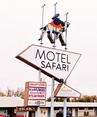
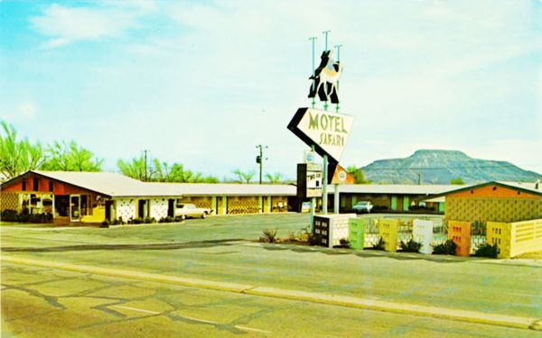
Motel Safari
Across the street, facing the old Shell station is the classic "Safari Motel" at 722 E. Tucumcari Blvd.
The Motel Safari was built by Chester Dohrer, in 1959 in "Googie" style (Pronounced "gu:gi"), with modern Atomic and Space Age inspiration. It has kept its original neon sign, with a person mounted on a camel (on a long journey or "Safari"; from the Arabic word "safar" = to travel).
Dohrer soon sold it to the Freys. The back of the postcard they printed says "23 lovely, well furnished units; Color T.V., Tubs and Showers, Room Phones; Carpeted; Refrigerated Air-Conditioning; Newly Refurbished throughout; Heated Pool. Owner-Managed Mr. & Mrs. Ronald Frey".
In 2007 the Talleys bought it, and renovated it, restoring its former beauty. Since 2017 it is run by its new owner, Larry Smith.
Orbit Lounge
Drive two blocks west, and at 508 E Tucumcari Blvd., to your left, on the SE corner of S. Jackson and 66 is the old "Orbit Lounge" now "Trails West Lounge".
It dates back to the early 1950s when it was a grocery store. In the early 1960s it had a more modern (Googie style) appearance.
Clint Eastwood frequented it during his stay in Tucumcari wth cast members of the TV series "Rawhide", where he starred as Rowdy Yates. The first episodes were shot in Tucumcari in 1959. The show was aired on CBS from 1959 to 1965.
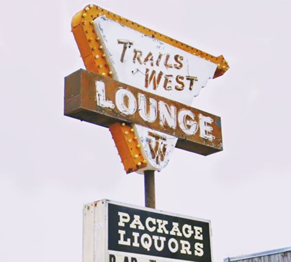
Now the lounge has an Old Western cowboy style with rustic wood slats, but the brick wall standing upright in the middle of the building belongs to the original design.
Its famous neon sign has also changed, losing its "space age" upper part with a ball (a satellite?) orbiting a winged ball (a planet?). See the old sign on the left side of the 1960s picture below.
Swift's Shell station (Vista)
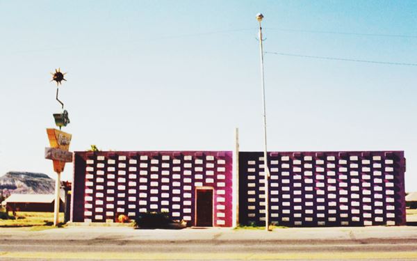
Across S. Jackson, on the corner, at 424 E Rte 66 is Swift's Shell station.
It has the Ranch-style adopted by Shell in 1960. It has a low-sloping gabled roof,
brick finish, a chimney-like extension above the roof (Shell's logo went here) and glazed service bay doors with large transoms above them to provide natural light.
Next to it on its western side is another classic motel and neon sign.
Americana Motel
Great Route 66 Neon Sign
Originally the State Motor Lodge

Postcard State Motor Lodge, Source
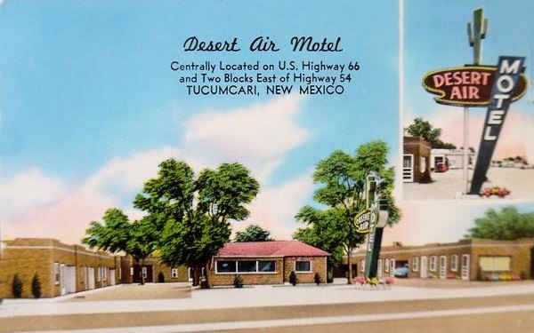
At 406 E. Tucumcari Blvd. This motel began in 1935 as the State Motor Lodge, with a "U-shaped" layout around a central cottage styled office, with carports between the units. Its postcard tells us it had "19 New Modern Units Panel Ray Heat - Foam Rubber Mattresses and Inner Springs AIR-CONDITIONED YOUR HOME AWAY FROM HOME Mr. & Mrs. W. L. Crotty, Owners & Operators."
Later the Desert Air Motel
The Crotty's later renamed it "Desert Air Motel", and upgraded its neon sign to the one that we see nowadays. According to this 1956 it postcard was "Your Home Away from Home... Family connecting suites
of two and three separate bedrooms to accommodate from four to eight guests." It was owned and managed by Bill and Dorothy Crotty.
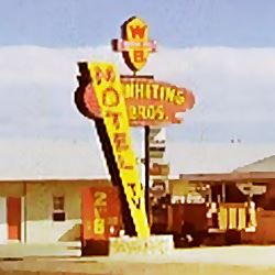
Then a Whiting Bros Motel
It was acquired by the Whiting Bros Oil company and added to their motel chain. Whiting owend around 100 filling stations and 15 motels in the Southwest, from Lenwood in California to Shamrock in Texas, many of them
on Route 66, but they went under during the 1973 Oil Crisis.
The neon sign was modified to reflec the new ownership: The word "TV" was written on the slanted part under "Motel", the cactus was replaced with the "WB" shield and the words "Whiting Bros" replaced "Desert Air"
in the oval (see below).
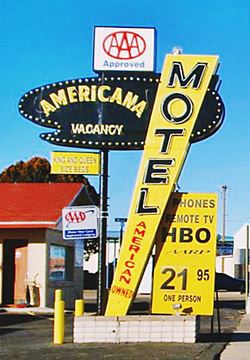
Finally: Americana Motel
The motel eventually became the Americana. The carport areas were enclosed and more rooms added. Fortunately the motel has managed to keep its fantastic Googie-style Neon Sign with some minor changes.
As you can see above, the newest neon sign replaced the "WB" shield with a box that says "AAA Approved" and "Americana - Vacancy" was written in the oval.
La Nora Court
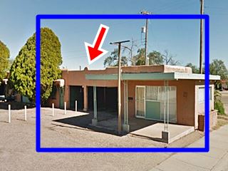
Across Route 66, on the north side of street, to your right, is a very Old Motel from the 1930s. At 401 E. Tucumcari Blvd.
The motel had a classic Spanish Mission style building and a Conoco gas station on the western side of the property (now gone). We outlined the motel building in blue and the Red arrow marks the prominent curved parapet on the roof, that still stands today. You can also see the garage belonging to the room.

Washing Lady Neon sign. Source. Click for St. view
Wash Lady Neon Sign
M&M Cleaners, whose trade name is Boulevard Cleaners, at 405 E Route 66 Blvd, is located on the site where the La Nora Court Conoco station stood.
The neon sign is based on the 1970s wooden one
hung beneath it, and was built in 1990. It is about 8 feet tall and is known as the "Wash Lady".
There is a story on the internet -we have not been able to verify it- that says the laundry was opened in 1952 by two brothers (Stanley and Lawrence Liu).
However, in the 1960s, there was no laundry here. It was a Standard Oil gas station.
Crossing Monroe St., on the block on the south side of Route 66 to your left, you will see a vintage gas station, a former cafe, and what once was a restaurant
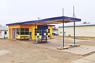
Former George's Texaco
374 E. Tucumcari Blvd. It was first known in 1945 as Linda Texaco, and was ran by Bill Williams offering "Washing, Greasing, Simonizing, and Battery Charging" (simonize is to polish a car).
Later it became George's Texaco.
The former Texaco gas station has a flat canopy over two gas pump islands and a two-bay multi-window service area. It is painted yellow and blue.
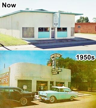
Ron Dy Voo Cafe
Next to the Texaco, at 312 E. Tucumcari Blvd. This building was a Café whose neon sign anounced: "Ron dy Voo - cafe - sea food, steaks and chops, curios".
The "Then & Now" sequence (See the postcard)
shows us that the flat roof has changed, the neon sign is gone, but the round corners with glass-brick have survived.
Its name comes from the french rendezvous: to meet at an agreed time and place. Its postcard tells us that "through its doors each year pass approximately 300,000 very welcome guests from all
parts of the world. It is a member of the world famous Esquire Diners Club".
Sylvia Anthony Restaurant
Following Ron Dy Voo, at 324 E. Tucumcari Blvd. The brick building at one time was the "Sylvia Anthony" restaurant which served Italian and American food.
It featured "Broasted Chicken" and was operated by Albert and Virginia Marks. The neon sign has gone, but the building is there. Later there was another one at 321 E Route 66, across the street, and one on the eastern side of town (1806 E Route 66).
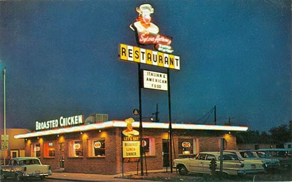
On the northern side of Route 66, the block also has some classics: a former motel and another restaurant.
Sahara Sands Motel
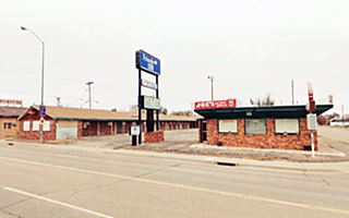
At the western tip of the block (315 E. Tucumcari Blvd.) is the former Sahara Sands Motel, later the Friend's Inn, now closed. Its postcard tells us that it was owned and ran by Mr. and Mrs. M. M. Whittington, that the motel had 32 units, with wall-to-wall carpets, King size beds, and "Thermostat Controlled Heat... Baby Beds - Playground - Restaurant - Heated Pool".
The restaurant (in the postcard) later became Joe's, currently closed. The awesome neon sign has been taken down.
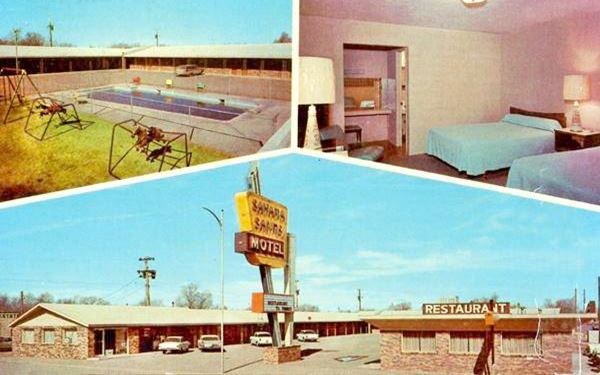
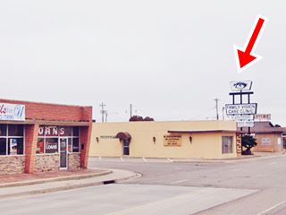
Ayer's Restaurant
It was located at "301 E. Gaynell Av. (HWY.66)", their advertisement said "We age & cut our own beef... Waffles & Pancakes all day.
All sea foods, Cocktails, Air Conditioned, Packaged Liquors. Closed Sundays" and they accepted American Express and Carte Blanche.
The building now houses Family Vision Care Clinic. The neon sign has been adapted, but the three steel poles are still there (red arrow in the images below).
Notice that the brick building (left side of images) across the street, on the NW corner of Route 66 and Adams is still there, but without the "66 Drugs" and "King's Western Wear" signs.

Ayer's Restaurant in the 1950s Full size image
Tommy's Steak Shop
Almost reaching the end of the next block, to your right is what used to be a Cafe, Steak Shop and Bar.
Located at 213 E 66, Tommy's Steak Shop occupied the western wing of the premises. It was operated by Mr. and Mrs. Tommy Almand.
They specialized in sizzling steaks, fried chicken and regular dinners.
The eastern tip of the building was a cocktail lounge, "The Hitching Post", but in the 1960s it moved west to 4th St. and W 66.
The building with curved glass-brick corners is still standing.
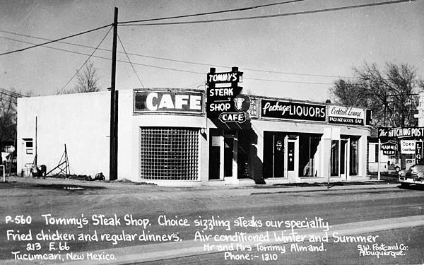
Next to it, on the NE corner of Main and E Route 66 was Byar's Mobil station, now gone. Facing it, on the SE side of Route 66 and Main St. (NM-209) is a classic Mexican restaurant.
La Cita
With its kitschy Mexican sombrero so typical of Route 66, this Mexican food restaurant is still open. The name means "the appointment", "the date".
Here on the corner of 1st St. and Route 66 we end the tour of the eastern side of Tucumcari. Go to Page 2 for more Tucumcari sights!
More Tucumcari attractions on the Next Page
We describe the rest of Tucumcari's attractions on Tucumcari Page 2
Sponsored Content

>> Book your Hotel in Albuquerque

Credits
Banner image: Hackberry General Store, Hackberry, Arizona by Perla Eichenblat
Robert Julyan. 1996, The Place Names of New Mexico. UNM Press
Jack DeVere Rittenhouse, (1946). A Guide Book to Highway 66.


