Index to this page
- New Mexico Route 66 Itinerary and maps
- Historic background
- Santa Rosa
- Clines Corners
- Moriarty
- Edgewood
- Tijeras
- Carnuel
- Albuquerque
Route 66 from Santa Rosa to Albuquerque
New Mexico Route 66 Itinerary and maps
Each leg of Route 66 described below has an interactive map and many image maps so you can follow the alignments of the highway along the way:
- Glenrio to Tucumcari - Map of this segment
- Tucumcari to Santa Rosa - Map of this segment
- Santa Rosa to Albuquerque - Map of this segment
- The Santa Fe Loop (1926-37) - Map of this segment
- Albuquerque to Lupton - Map of this segment
Arizona, next leg
Texas, previous leg
Santa Rosa to Albuquerque along Route 66
Historic Background of this section of US Highway 66
Route 66 was created in 1926 and it used pre-existing highways as its first alignment. The original highway in the area was the "Ozark Trail", the efforts of a privately sponsored highway system created in 1913.
The Ozark Trails was part of a "better roads" movement that lobbied for good highways that could be used by motor vehicles, and also signs to mark them and help drivers to find their destination.
There were monuments shaped like obelisks that marked the way along the Ozark Trail. One of them was built nearby, in Tucumcari in 1918, it is pictured below.
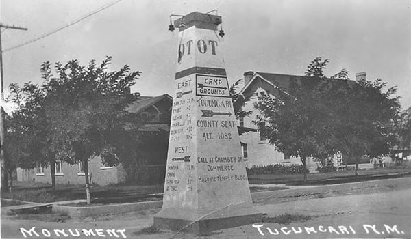
New Mexico authorities improved the original Ozark Trail in 1914 and designated it as New Mexico State Highway 3.
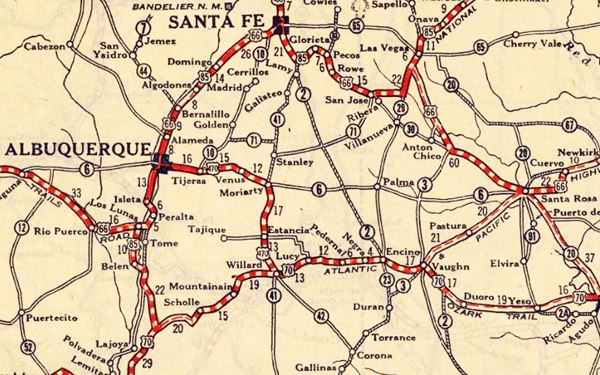
The thumbnail (Click to see large size map), shows some of the "Auto Roads" or "Auto Trails" that could be driven by cars in 1912 in the area between Albuquerque, Santa Rosa and Santa Fe. These trails are marked with red lines.

1912 Road map, central NM
Click on image to enlarge.
Source

1925 Road map, central NM
Click on image to enlarge.
Source
The map above (from 1925) -click on thumbnail to see large size map- shows the roads that existed one year before Route 66 was created.
Those marked "22" (National Old Trails Rd., coming from Los Angeles) and "32" (New Santa Fe Rd.) with white letters in a black box, went from Santa Rosa to Albuquerque through Santa Fe. Highway "50" (Ozark Trails) had two forks, one from Albuquerque to Moriarty and then south through Clovis into Texas, and another from Santa Rosa to Dillia.
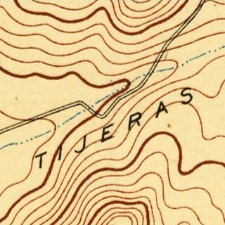
The only paved sections (full black line) was between Albuquerque and Tijeras. The highway from Bernalillo, Santa Fe, Pecos and Romero was "improved" (dashed line), the rest was either graded or dirt roads.
Route 66 was aligned along this road that curved north, from Santa Rosa to Santa Fe, and then south to Albuquerque. Map Below.
The Santa Fe Loop (1926 - 1937)
This was the first alignment of Route 66, from Santa Rosa to Albuquerque via Pecos and Santa Fe.
We describe the Santa Fe Loop in a dedicated webpage, with the full alignment, from Santa Rosa, through Dillia, Pecos, Santa Fe, and Bernalillo all the way to Albuquerque.

A political dispute between New Mexico Governor A. T. Hannett and local politicians led to the realignment of Route 66 in 1937.
Hannett blamed the local party bosses when he lost his 1927 bid to re-election. He decided to punish them, and their backers (the business men in Santa Fe) so he quickly had state highway #6 built, in 1927, to link Moriarty with Santa Rosa. This highway bypassed the capital city, and was 90 miles shorter for those driving from the east to Albuquerque.
In 1937, the Federal roadbuilders decided to realign Route 66 using Hannett's road, and paved it.
Route 66 leaves Santa Rosa
We describe this section from east to west, starting in Santa Rosa.
From Santa Rosa the original 1926-85 Route 66 followed the current Historic Rte. 66 for a short distance, until it meets the freeway at Exit 273. From this point westwards, all the way to Moriarty, it is almost completely buried under the Interstate's roadbed; we will describe the few exceptions below. This is the map with directions of US66 as it leaves Santa Rosa.
Original 1926-37 Route 66: heads north towards Santa Fe
>> pale blue line in our custom map is the 1937-85 alignment from Santa Rosa westwards
Ahead the higway takes an east to west course and the original 1926 - 37 Route 66 to Santa Fe forks off to the north along Highway 379 at Exit 267.
Here is the first segment of the original Route 66 roadbed that is not buried beneath the freeway. You can see it on the north side of the Freeway (orange line).
>> orange line in our custom map is the old roadbed at Exit 267
Original Route 66 and US 84 towards Dillia and Santa Fe
The 1926-37 alignment of Route 66 or "Santa Fe Loop" can be driven (dirt road! be careful!) in the first part of its alignment northwards towards Dillia (this is a map showing this section).
But further north the old road can no longer be driven, it becomes a mere trail. You can see it in the map below: driveable (yellow line), non-driveable (violet line).
As we mentioned above, in 1937 Route 66 was realigned with a westerly course to Moriarty, and US 84 was improved and linked to this new road, along what is now its current alignment.
>> yellow and purple lines in our custom map is the 1926-37 alignment to Dillia
Onwards to Clines Corners 1937-85 Route 66
>> pale blue line in our custom map is US66 to Clines Corners
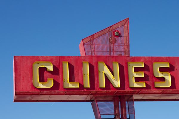
The road continues towards Clines Corners; and most of the way US 66 lies under the freeway, but you can see it at the following locations:
- Vaughn Truck Stop (Baca). The orange line is the old roadbed, the violet lines mark the gaps in the roadbed east and west of it.
- Orange line marks the roadbed at 4F Rd.
- orange line is Rincon gap.
Towards Moriarty
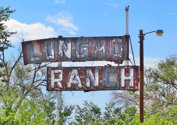
The highway heads west towards the next town overlaid by I-40. With one old segment visible at Longhorn Ranch:
>> navy blue line in our custom map is the 1937-85 US 66 west of Clines Corners.
orange line in our custom map is the gap at Longhorn Ranch, the black lines are the gaps at both ends.
Old Longhorn Ranch Sign
>> red line in our custom map is the east Moriarty missing roadway

1950s USGS map of Moriarty
Westwards the original road is again overlaid by the freeway (green line) with gaps (black lines) at each end where it returns to the S. Frontage Rd.
Route 66 in Moriarty
At I-40's Exit 197, the gap ends, and on the south side of the freeway, the highway runs straight west into Moriarty, and on its western side takes a SE to NW course, (map with directions) See the red line in our custom map.
There is a gap (black) on the western side of town that accommodated the access ramps to Exit 194.
>> red line in our custom map is the Moriarty to Edgewood US66
Moriarty Whiting Brothers Service Station


1937 roadmap near Tijeras Source. Click image to enlarge
Follow NM-333 along the original 1937-49 Route 66 alignment that went all the way into Sedillo.
To Edgewood
Westwards, the higwhay runs with a SE to NW course n all the way to Edgewood parallel to the freeway (red line in custom map) running across the small community.
It then heads in a straight line towards the foothills of the Sandia Mountains.
Reaching them in Sedillo Hill.
Here there are several alignments to cross it and enter Tijeras Canyon on the western side of the divide.
>> green line in our custom map is US66 west of Edgewood.
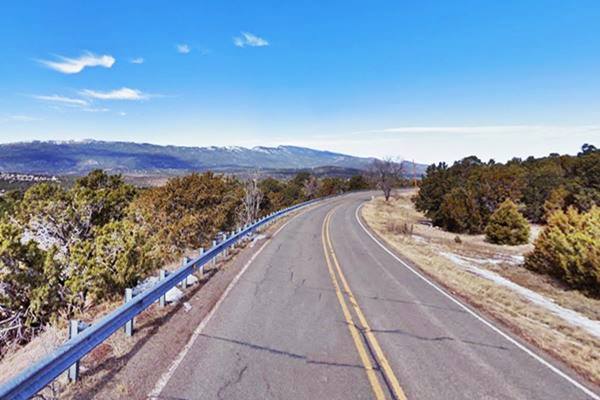
View along the Sedillo Hill Road at its highest point
Route 66 alingments in Tijeras Canyon
There were three alignments from Sedillo to Albuquerque along Tijeras Canyon. The first runs into and across the village of Tijeras:
1. 1937-45 alignment of Route 66
The first alignment took a longer course from the highest part of Sedillo Hill from what is now Exit 181 on I-40. Here it is now cut by the freeway, starting at Brad Ct. on the south, to Hwy. 306 on the north, as marked with a yellow line line in our custom map
Westwards it follows Hwy. 306 in a wide curve towards the north in a loop through Sedillo and then back to the south into Tijeras Canyon on the downhill side. This is segment can be driven. It is a narrow, and winding road (pale blue line in our custom map).
Sedillo is the highest point east of the Rocky Mountains
The village of Sedillo, in Sedillo Canyon at the foot of Sedillo Hill, near the highest point of Route 66 east of the Continental Divide.
Along the original 1937 alignment on Sedillo Hill Road (NM-306) US66 reaches its highest point of Route 66 east of the Continental Divide in the Rockies: Sedillo Hill.
Highest Point of Route 66 east of the Continental Divide
Exactly at Kimberly lane and NM-306 (Sedillo Hill Road). Exact Spot (street view).
Altitude: 7,102 feet (2.166 m)
The old 1937 alignment of Route 66 curved around Woodland Hills and reached the highest altitude east of the Continental Divide.
Highest Spots Along Route 66
Continental Divide is the current highest spot on Route 66. There are several passes along Route 66 where it crosses mountain ranges, the highest spots are the following:
- 7,550 feet (2,301 m). Glorieta Pass NM, Sangre de Cristo Mountains. Highest point from 1926 to 1937. On the Santa Fe Loop.
- 7,405 feet (2,257 m). Bellemont to Parks, Arizona, crossing the San Francisco Mountains, 1931-41 alignment.
- 7,245 feet (2,208 m). Continental Divide, New Mexico, crossing the Rocky Mountains. 1927-85 alignment.
- 7,102 feet (2,166 m). Sedillo, NM on the 1937-45 alignment, replaced when it was realigned, by a spot at 7.057 feet (2,150 m). Comer's Cafe close to Sedillo on the 1945-85 alignment. Crossing the Sandia Mountains.
- 3,595 ft (1,096 m). Sitgreaves Pass near Oatman, California, crossing the Black Mountains. 1926-53 alignment.
On the western side of the divide it ran along the northern side of Tijeras canyon, along what is now North Zamora Rd. The first part is cut off by I-40 (black line in our map). It follows Zamora Rd along a driveable segment (Zamora Rd. map with directions - orange line in custom map). There is a gap at its western tip where it crosses to the south side of I-40 into Tijeras village (black line in our map), continuing along the south side of the freeway (orange line.
2. 1945-50s dual lanes
When Route 66 became too crowded during WWII, a straighter course was planned and built in the mid 1940s and it ran along the south side of the canyon; it only had two lanes. This alignment follows the modern South Frontage Rd. as shown in this 1945-50s US 66 map with directions from Sedillo, through Zuzax and into Tijeras.
>> red line in our custom map is the 1945-50 two lane US66 into Tijeras
It met the earlier alignment in Tijeras and the 1937-50s highway ran westwards, down the canyon along a course that was altered by the construction of the mid 1950s four-lane highway, and later by I-40 that was built over it. The violet line in our custom map shows this alignment through Tijeras and westwards towards the next town, Carnuel.
The original highway in tijeras ran roughly where the eastbound lanes of the freeway now run (red line in our map).
The highway follows a driveable section towards the Dead Man's Curve (pale blue line in our custom map.)
3. 1950s-70s four lanes in Tijeras Canyon
Growing traffic led it to be upgraded to a four lane highway in the 1950s, but this took some time, even in 1961 there were sections with 2 lanes in the Canyon.
This type of "superhighway" was divided but lacked overpasses and underpasses. It had grade crossings and unlimited access to the trading posts along it. It lies mostly where I-40 was later built in the 1970s.
Route 66 alignments in Carnuel
There were several alignments over the course of the year along lower part of Tijeras Canyon. Further down we describe them at Dead Man's Curve
The original two-lane highway was upgraded to 4-lanes in the 1950s.
Dead Man's Curve
On the western side of Canuel, Tijeras river passes through a narrow section of the Canyon, where it turns north and then west again. The locals called it "La vuelta de las Cuchillas" which in Spanish literall means "The Turn of the Knives", however "Cuchillas" also means a steep knife shape mountain; the latter is a better description of the spot: a deep narrow valley with towering hills on both sides and an "S" curve in the river.
1. Original alignment at Deadmans Curve
We marked it with a black line in our custom map
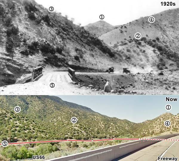
The image map from 1890 shows how the original dirt highway up the canyon crossed the river twice, on both sides of the canyon -click on image to enlarge the map. It avoided any cuts; the higway went down to the river and followed the steep hills on its southwest and southern banks.
The image below combines a current view with a 1920s picture lookingwest along the road. You can see the same features in both numbered (1) to (5). The red line marks the approximate alignment of the old highway, along the south and western side of the canyon. Dashed line shows where it is obstructed by the hill and I-40 embankment on that nowadays cuts the river and obliterated the original alignment. The 1950s four lane Route 66 can be seen (lower left) on the bottom image.
There was another alignment from the 1930s to 1950s that was built hugging the northern and northeastern side of the canyon but it too was destroyed when the 1950s alignment replaced it. I-40 removed another part of the old section, but you can still see the western part of this 1930s-50s roadbed (more on this further down).
2. 1926-50s two-lane highway at Deadmans' Curve
We marked it with a orange line in our custom map
From 1926 to 1937 US 470, later renamed US 366 ran through Carnuel. In 1937 it became Route 66. It was a two-lane highway that was straighter than the original dirt trail. So a new alignment was built along the north side of the Canyon. The roadway clung to the slope, on its wester side an embankment was built and close to the curve a cut was made in the slope, at the curve, the SW tip of the hill was cut and a sharp curve followed. The highway climbed up to the cut, and then down towards the river on its eastern side. This cut on the hill's tip was later deepened by the 4-lane highway to reduce the grades and finally eliminated by I-40 that plowed across it.
Below are some postcards looking east along the canyon towards Dead Man's Curve, click on them to enlarge:

1930s view Dead Man's Curve, Carnuel. Source
Click image to enlarge
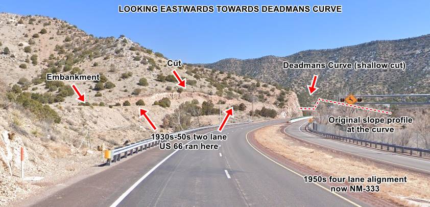
Current view Dead Man's Curve, Carnuel. St. view
Click image to enlarge
In the 1930s image you can see Child's Motor Court to the left, and the winding Route 66 climbing towards the curve.
3. Four Lane Route 66 (1950s)
The increase in traffic and safety concerns led to a four-lane highway being build in the 1950s. This aerial photo from 1951 Shows the four lane road under construction at the curve.
The first postcard below (Click on both of them to enlarge), from the 1960s shows the curve itself. Now I-40 cuts across here, and it eliminated the original curve (1930s-50s '66) that we marked with a red arrow (upper left):

Early 1960s view Dead Man's Curve, Carnuel. Source
Click image to enlarge

Early 1950s view Dead Man's Curve, Carnuel. Source
Click image to enlarge
The second image above shows the same view shown in the 1930s and current picture looking east along the Canyon towards the cut at its SW tip. Notice how it has grown deeper.
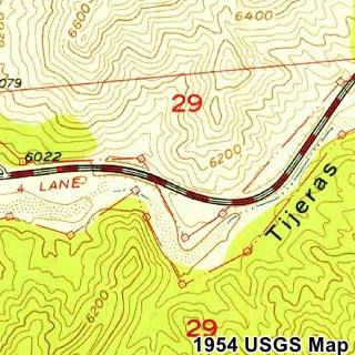
The USGS map published in 1954 shows the four-lane US66 in Deadmans at that time.
4. Freeway I-40
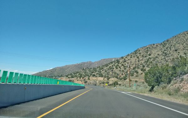
By 1980 (1981 aerial photo) the interstate had been built in a straight course across the curve. The old four-lane '66 became NM-333, and it passed beneath I-40 at the curve.
Below is a view looking west, notice the cut of Old 66 on the slope ahead.
View along Route 66, heading west after the former "Dead Man's Curve" at Carnuel
Other Dead Man's Curves on Route 66
There were more deadly sharp curves on Route 66, follow the links to learn about some of them:
Carnuel
On the western side of the deadly curve the highway runs across Carnuel in a straight line.
>> violet line in our custom map is the Carnuel alignment.
It was in Carnuel, looking west towards Albuquerque that the following picture by Jim Wray, taken in 1958 shows how the four-lane highway crossed a hill located where modern I-40 and NM-333 (old Route 66) cross each other at Exit 170.
Looking west along the WB lanes of US66 in 1958
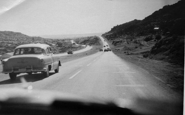
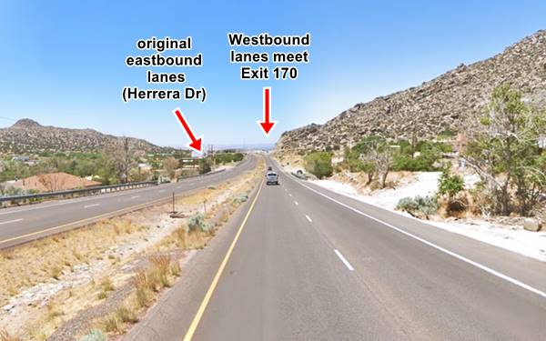
Notice how the original highway (eastbound lanes) on the left, skirted around the hill ahead, while the westbound lanes (right) kept a straight course and climbed it. Nowadays, the old EB lanes run along Herrera Dr SE but are cut by I-40. The WB lanes have cut deeper into the hill, to reduce the grade as they reach Exit 170 as you can see in the following picture:
Looking west along the WB lanes of US66 nowadays
Elephant Rock
Drive west (map), here the original Route 66 alignment has been disturbed by the construction of I-40 and the interchange at Exit 170. The original highway followed the alignments marked with red and blue lines in our custom map.
There is a short surviving segment of the old EB lanes on Herrera Dr. (map and 1951 aerial photo)
To your left on the south side of the highway is the spot where once stood a strange rock formation known as Elephant Rock.
Looking west towards Elephant Rock, vintage photo
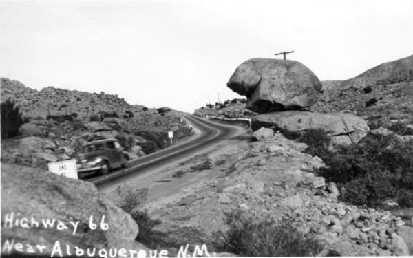
The exact location of Elephant Rock is shown in this Map marking the spot of the Elephant Rock. See the red marker in our custom map.
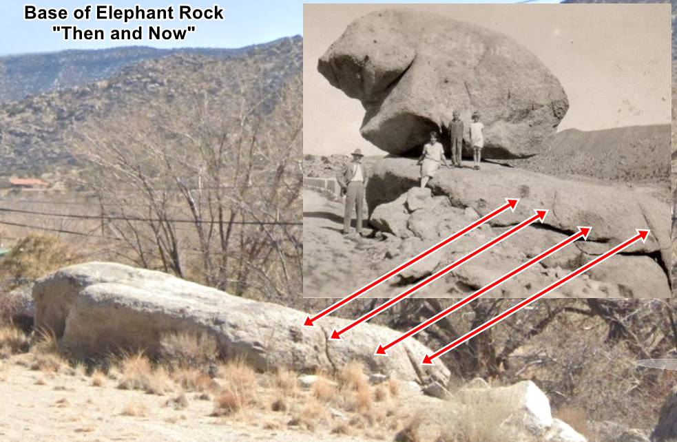
The "rock" was a large boulder set upon another flat rock that served as its base as you can see in the picture (the red arrows mark the same features in both images). It was set close to the shoulder, on the south side of Route 66. The upper rock seemed to balance on the base. It received various names: "Balanced Rock", "Teapot Rock", and "Elephant Rock".
It was the most famous natural landmark of Carnuel Canyon, and people stopped to take photos beside it.
When Route 66 was widened in the 1950s, the "Rock" was considered a nuisance or a danger for large sized vehicles, so it was toppled over. It lies beside its pedestal (that survived) and is resting tumbled on the south side of the road close to its base.
Below are two "Then and Now" images showing the same spot (we added a white square to the 2023 view, marking the position of the rock on top of the pedestal), the red arrows mark the same landscape features. Click on images to enlarge them:

1940s Elephant Rock, US 66 Carnuel Source
Click to enlarge

1940s Elephant Rock, US 66 Carnuel St. view
Click to enlarge
Western Carnuel and Albuquerque
By the mid 1950s, according to the 1954 USGS map, it became a 4-lane highway on the western side of Carnuel, and then met Central Avenue, to enter Albuquerque.
green line shows the course of the original two lane highway into Albuquerque towards the point where it met Central Avenue.
Albuquerque end of this leg
The highway enters the city straight along Central Avenue:
>> yellow line in our custom map is the 1937-85 US 66 into Albuquerque
At 4th Street in downtown Albuquerque it meets the 1926-37 alignment from Santa Fe. It is one of the few places along Route 66 where two alignments cross each other.
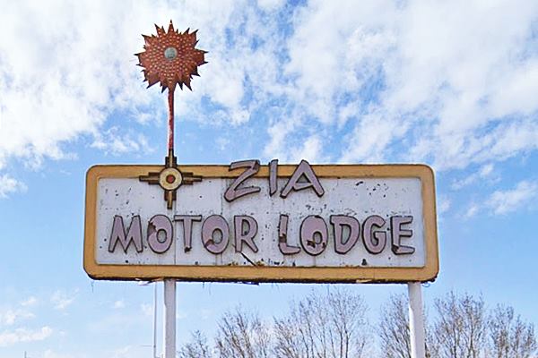
The original 1926 alignment ran along 4th Street across Albuquerque with a North to South course, from Santa Fe towards Isleta. It was the main highway and throughfare. This is the end of this leg.
Route 66 Alignments

Some sponsored content
>> Book your Hotel in Santa Rosa

Credits
Banner image: Hackberry General Store, Hackberry, California by Perla Eichenblat
Jack DeVere Rittenhouse, (1946). A Guide Book to Highway 66


