Index to this page
Historic Route 66 Glenrio - Tucumcari
New Mexico Route 66 Itinerary and maps
Each leg of Route 66 described below has an interactive map and many image maps so you can follow the alignments of the highway along the way:
- Glenrio to Tucumcari - Map of this segment
- Tucumcari to Santa Rosa - Map of this segment
- Santa Rosa to Albuquerque - Map of this segment
- The Santa Fe Loop (1926-37) - Map of this segment
- Albuquerque to Lupton - Map of this segment
Arizona, next leg
Texas, previous leg
Glenrio to Tucumcari Historic Route 66
Route 66, Tucumcari to Tucumcari, NM.
Listed in the National Register of Historic Places.
This is the historic segment of Route 66 from Glenrio to Tucumcari.
Starting point, Glenrio
Little Juarez Diner, Glenrio, Texas
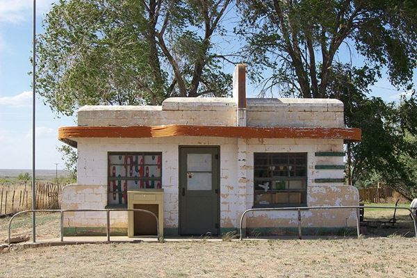
Drive west along Route 66 from Glenrio (Texas), this was the alignment of Route 66 from 1926 until it was replaced by the freeway.
For information on the previous section, visit our page Route 66 from Amarillo to Glenrio.
Brief History of this segment of US 66
Route 66 was created in 1926 as part of the US highway system. But it was preceded by other highways and was aligned along some of them.
The "Ozark Trail" was a private association that promoted better highways. In the 1910s it marked out a "trail" that could be driven by cars (known as "Auto Roads") across the country. The Map below, published in 1912 shows some of these auto roads (full red lines) in eastern New Mexico.
National Old Trails Map Glenrio and Tucumcari area from 1912
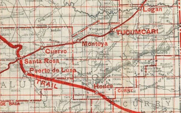
This trail bypassed San Jon, Bard, Endee and Glenrio. Instead it headed to the northeast through Logan.
The map below (from 1925) shows how the "Ozark Trails" (marked with "50") and the "Coast to Coast Route" (marked with "72") ran from Glenrio to Tucumcari. The road was a "Dirt Road" in this segment.
Vintage Road map, Glenrio to Tucumcari. 1925
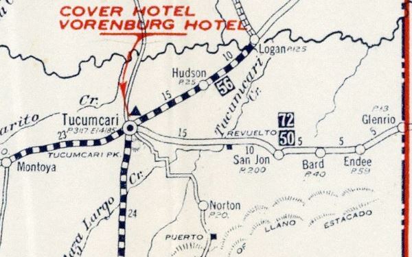
In 1926 Route 66 was aligned along this highway from Glenrio to San Jon.
Route 66 Map through Endee. 1939 (original alignment 1926-52)
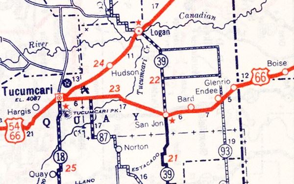
1952-1973 Alignment near Glenrio
The alignment out of Glenrio
Now the road is empty, but in 1961, on an average day, some 3,500 vehicles crossed the line between New Mexico and Texas along this stretch of Highway 66.
The paved alignment west of the state line is shnort; it ends half a mile west of Glenrio (yellow line in our custom map).
>> yellow line in our custom map is the 1926-70s Glenrio alignment
There is a fork in the alignments here, to the left is the 1926-52 Route 66 and to the right is the 1952-73 Route 66 alignment. We describe them below.
The Blue arrows in the image mark the 1926-52 alignment, the Red arrows show the 1952 alignment. I-40 cuts across it.
1952-73 US 66 (abandoned) Glenrio
The 1952 alignment of Route 66 forks to the right and can't be driven because it is cut off by I-40. It was the course taken by Route 66 after 1952 and until Oct. 1, 1973. It heads northwest and then curves to the southwest on the north side of I-40. It is cut off on both sides of the freeway, and can only be driven west of NM-93 towards San Jon, at I-40 exit 369.
>> navy blue line in our custom map is the abandoned 1952-73 Glenrio US66
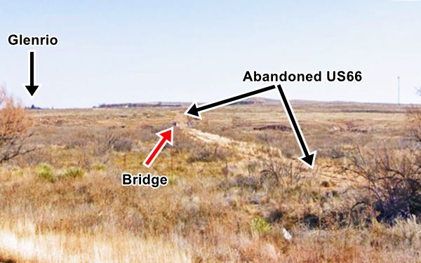
Glenrio Bridge
There is also a bridge on this section, across Trujillo Creek. It has a total length of 500 ft, and is closed to traffic. It was abandoned in 1973 when I-40 bypassed this segment. The image below shows the view from the freeway's eastbound lanes, looking towards the southeast. You can see the abandoned roadbed (black arrows), the bridge (Red arrow) and in the distance, Glenrio.
Glenrio to San Jon Historic Route 66 (1926-52)
Route 66, Montoya, NM.
Listed in the National Register of Historic Places.
This segment begins in Glenrio, on the state line, heads west and at the fork of the later 1952-73 alignment, heads to the SW. It goes through Endee and Bard, to end in San Jon.
>> red line in our custom map is the 1926-52 Glenrio San Jon US66
The "Modern Restrooms" in the foreground, at Endee.
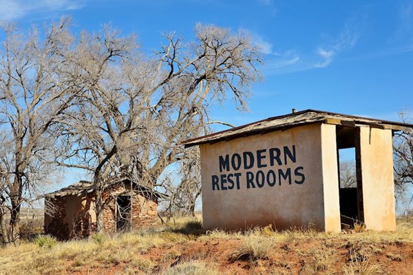
It is maintained by the county. The easternmost part of this road is a four-lane highway with a concrete median which was built in 1951.
The rest of the segment is now a dirt road with a gravel surface. There are some spots where the 1950s asphalt can still be spotted.
The county removed the asphalt cover to make it easier (and cheaper) to maintain. Driving along this segment is like traveling back in time to the late 1920s.
Dirt surfaced Route 66 between Glenrio and Endee

It dates back to 1926, and initially it had a winding course, to cross the different creeks flowing into the Trujillo and San Juan streams. This meant that it also crossed the railroad. In 1930 it was realigned under FAP 127-A to eliminate the grade crossings with the Chicago and Rock Island, and Pacific Railroad. And several wood bridges were built across the brooks close to Endee. It was also paved.
This road section was paved in 1930 and served as Route 66 until 1952.
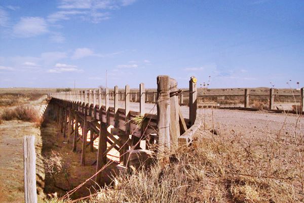
The Wooden Cyprus Bridge is one of these timber bridges built in 1930. It is located 2.1 mi. west of Endee. It was built with cresote-treated pine timber. Its deck is built with laminated wood so that it could easily be repaired by unskilled workers.
Route 66 crossing a wood bridge west of Endee NM
Endee
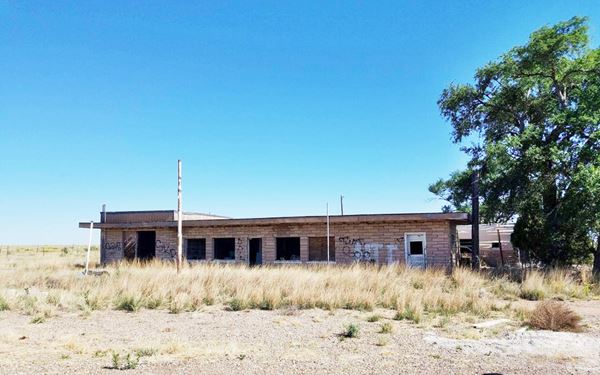
The road runs parallel to the railroad tracks, passes through the ghost town of Endee that is located 4.7 miles west of Glenrio, along the old Route 66. All that remains of Endee, is the abandoned motel, with its famous "Modern Restrooms", and several wood bridges.
Bard
The highway goes through a second ghost town, Bard, of which nothing remains, its main business moved to a new spot on the 1952 alignment one 3⁄4 north of the old townsite.
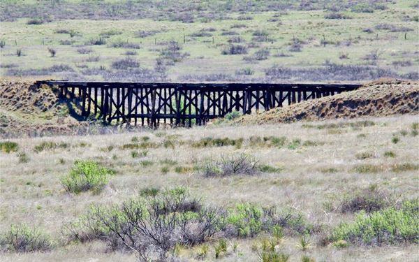
Route 66 crosses well irrigated, rolling rangeland. Barbed wire fences run parallel to the highway and to the south are the now abandoned railroad tracks with some wood tressles of the railway causeways.
The dirt-gravel section ends two miles east of San Jon, just as US66 converges on the interstate.

1952-73 Alignment to San Jon
From Russell's Truck Stop, at the western tip of the abandoned segment of US66 mentioned further up, the north frontage road runs parallel to the freeway. This road was the 1952 to 1973 alignment of Route 66.
>> pale blue line in our custom map is the Glenrio to San Jon 1952-73 alignment
Bard on the 1952 alignment
At Bard's Exit 361 you can see the Bard Trading Post.
Bard Trading Post nowadays on the 1952 US 66 alignment
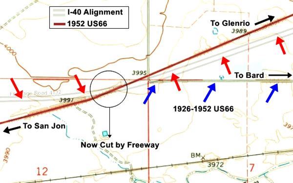
Two miles west, the frontage road and the freeway curve and take an east-west alignment. This is the point where Route 66 continued straight with its SW direction -now overlaid by the freeway- and met the earlier 1926-52 US 66 that is now on the southern side of I-40. This is shown in the following map. Where we overlap the current highways with the USGS map from 1968.
>> black line in our custom map is the gap at St Jon
The image below shows the junction of alignments: Blue arrows mark the 1926-52 alignment, the Red arrows show the Freeway (parallel gray lines). The red line marks the 1952-73 US 66, cut by I-40 in the area marked with the circle.
San Jon
The 1926 highway west of this point is paved. It enters San Jon along its main street.
>> yellow line in our custom map is the 1926-70s San Jon alignment
US 66 from San Jon to Tucumcari
Route 66, Tucumcari, NM.
Listed in the National Register of Historic Places.
This segment is also a historic landmark listed in the National Register of Historic Places. It is fully paved.
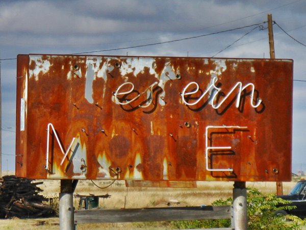
Can you read the motel's name?
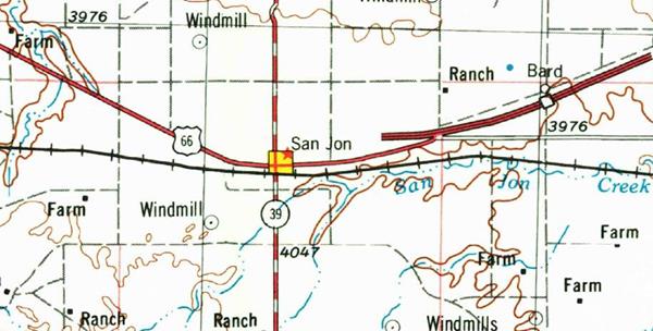
The USGS map below printed in 1968 shows the progress of I-40 as it was built in the late 1960s. You can see how it ends on the eastern side of San Jon, and how it continues along the 1926 alignment into the town. The map also shows (dashed line) the 1952 road through Bard, and the 1926-52 US66 can be seen running straight east (two parallel black lines). West of San Jon, the original road hadn't been replaced by the interstate at that time.
The southern frontage road of I-40 is the alignment of Route 66, see this Map with direction to Tucumcari, at Tucumcari, I-40 cuts the original alignment so after crossing it at Exit 335, continue on the north side of the interstate all the way into the city.
>> yellow line in our custom map is the San Jon to Tucumcari map 1926-70s
Of course, the frontage road curves around several overpasses that bridge I-40 between San Jon and Tucumcari, here too, the original alignment has been erased. The frontage road skirts around them.
>> black line in our custom map is the gap at Tucumcari
Cedar Hil Store and Station
The only point of interest close to San Jon is the former Cedar Hill Grocery Store and gas station, 8.5 miles west (Map with directions). This spot appears in the 1925 road map as "Revuelto" and Rittenhouse mentions it as "Gas Station".
It was owned in the mid 1960s by Charlie and Lillian Murray. It has fallen into disrepair, and the canopy has collapsed.

The road was paved and straightened out in 1933, but the pre-1933 alignment of the road is visible fifty yards to the south of the present roadbed after Cedar Hills (see this segment west of the Revuelto Creek in a Satellite view).
>> violet line in our custom map is the 1926 US66 in Cedar Hill
Lesbia
Further ahead, at the junction of US 66 and QR Ag (15 mi. west of San Jon), take a left along QR Ag and after 0.7 mi. you will reach Lesbia, which once was a station on the Rock Island Railroad.
It was named Rudulph from 1908 to 1910, then Castleberry (till 1913) and finally Lesbia, until 1918 when the post office closed.
As you reach Tucumcari, to your left there is a former shop or trading post (Street View).
Tucumcari end of the journey
Drive into Tucumcari, the endpoint of this segment of your Route 66 road trip.
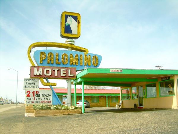

Sponsored Content
>> Book your Hotel in New Mexico

Credits
Banner image: Hackberry General Store, Hackberry, California by Perla Eichenblat
Jack DeVere Rittenhouse, (1946). A Guide Book to Highway 66.


