"The Zinc City"
Index to this page
About Webb City Missouri
Facts, Trivia and useful information
Elevation: 1,001 ft (305 m). Population 13,031 (2025).
Time zone: Central (CST): UTC minus 6 hours. Summer (DST) CDT (UTC-5).
Webb City is located on Route 66 in Jasper County in the southwestern corner of Missouri, beside Kansas & Kansas.
Webb City in a 1913 Postcard; Main St. and W. Daugherty
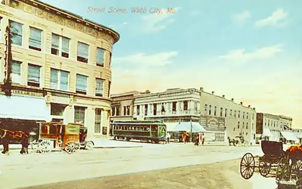
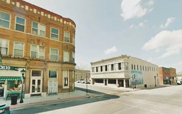
In the "Then and Now" sequence you can see that the Unity Building and Merchant and Miners Bank (left) and Historic Pharmacy (right) are still there, though the streetcar has long since gone.
Webb City, today, the same spot as the one shown in the postcard above.
The history of Webb City

John Cornwall Webb. Source
Southwestern Missouri has been inhabited for the last ten thousand years. The native Osage arrived here ca 700 BC from expelled by the Iroquois from their land along the Mississippi and Ohio Rivers. In 1682, the French explored the area naming it after their King Louis XIV: Louisiana and what would become Missouri was part of the Upper Louisiana district.
France ceded the territory to Spain in 1763 after the Seven Years' War, but Napoleon recovered it in 1800, only to sell it to the U.S. in 1803.
It became a U.S. Territory in 1812 and incorporated to the Union in 1821. In the meantime treaties signed with the Osage (1808, 1818, and 1825) made them give up their land in Missouri, Arkansas, and Oklahoma in exchange for a reservation in the latter territory.
Jasper county was created in 1841 and Carthage was named county seat in 1842. In 1855, John Cornwall Webb (1826-1883) followed his father and uncle and moved there from Tennessee, buying 320 acres. He fought in the American Civil War during the early 1860s, when Carthage was evacuated and completely destroyed in two battles.
Webb found a solid lump of lead while plowing his farm in 1873 and joined up with W.A Daugherty to mine his land. However, after battling with water that flooded his digging he sold his share and leased his land to Daugherty and Ashcroft in 1875.
That year he platted the townsite as miners flocked in, to settle in Joplin. The town incorporated in 1876 and became the home of the wealthy mine owners.
The St. Louis and San Francisco Railroad reached the town in 1879 and in 1893 the Streetcar linked it with the major cities in the area.
In 1880, Webb City was dubbed the "Zinc Capital of the World". Lead and zinc were the basis of the economy that grew greatly between 1875 and 1918, when, after World War I, production declined. The town then industrialized in the 1920s.
The name: Webb City
The town was named after its founder, John Webb. The surname is the occupational name for a weaver (webbe in Middle English).
In 1926 Route 66 was aligned through it. Cars displaced the streetcar and the gravel from the mine shafts (known as "chat") was used for road building.
The streetcar closed down in 1939 and mining ended after World War II. Later Route 66 was bypassed by I-44 which opened in 1958 from Oklahoma City to Joplin and then headed east along US-166.

Where to Lodge in Webb City Missouri
You can find your hotel romm close to Webb City in neighboring Joplin or Carthage.
> > Book your hotel nearby, in Carthage or Joplin
More Lodging near Webb City along Route 66
There are several hotels in the area close to this town. Alternatively you can also find your accommodation along Route 66 in the neighboring towns and cities in Missouri. We list them below (from east to west):
On Route 66's Main alignment in MO
Eastwards
Westwards
- Hotels in Kansas
- Baxter Springs KS
- Galena KS
- Riverton KS
- Hotels in Oklahoma
- Miami OK
>> Check out the RV campground nearby, in Joplin
Weather in Webb City
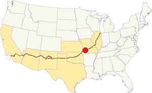
Location of Webb City on Route 66
Webb City's climate is wet and subtropical, with humid, rainy summers and cold and dry winters. Most of the rainfall takes place between April and July, the "severe weather" period.
Rainfall averages 46.5 in per year (1.180 mm). And 11.9 in. of snow (30 cm) falls each winter.
The summer (Jul) average high is 90.6°F (32.6°C) and the average low is 69.° (21.1°). During winter (Jan) the average high is 44.9°F (7.2°C). The average low is a cool 25.0°F (-3.9deg;C).
Tornado risk
Webb City is located within the infamous "Tornado Alley" and has its share of tornados (some 6 tornadoes hit Jasper county each year).
Tornado Risk: read more about Tornado Risk along Route 66.
Map of Route 66 in Webb City
US 66 Alignments in Webb City
>> Custom map with the alignments of US66 in Webb City.
Route 66 crossed the town from East to West and turned South along Jefferson St. (teal color in our map), but now it is cut by the highway median on W MacArthur Dr.
It carried on straight south, along S. Jefferson St. and then curved (see image) onto S. 14th St. to reach S Madison St. and head towards Joplin as shown in our custom map.
1937-45 US66. Later Alt 66
Later it was realigned (blue line in our custom map), and continued west and then curved into MacArthur Dr. to reach Joplin further west.
1958-78 Route 66 in Carterville and Webb City
In 1958 US 66 was realigned with US 71 along what is now I-49 BL, from Madison St. in Webb City, on the southern and western side of the town, and Carterville. See the orange line in our custom map. After 1978 the Mother Road was cut short and ended just east of Joplin, in Scotland MO.
Route 66 Alignment near Webb City
Visit our pages with old maps and plenty of information about US 66.
- Route 66 in Kansas (next)
- Springfield to Joplin (Webb City's)
- Rolla to Springfield (previous)
Route 66 Sights in Webb City
Landmarks & Stops
Historic context, the classic Route 66 in Webb City
Jack DeVere Rittenhouse drove U.S. 66 in 1946 gathering data for his book "A Guide Book to Highway 66". This information is very useful for for those seeking to know more about Route 66 during its heyday. He wrote the following about this town.
Midwest Hotel; Empire garage; stores... This was where the first important lead discovery took place when John Webb, who was a local farmer found a chunk of pure lead Rittenhouse (1946)
He added that Webb City did not suffer the fate of neighboring Carterville when the mines closed as it had an industrial base.
We will begin our road trip across the town on its eastern side, driving westwards from Carterville.
Streetcar overpass remains
Between Webb City and Carterville, on the north side of Route 66 you will see some concrete abutements with wingwalls belonging to the tramway (streetcar) that formerly linked the whole region, from Carthage in the east, through Carterville, Webb City and Joplin to Galena, KS and Commerce and Miami in OK, in the west.
"Then and Now" pictures of the viaduct
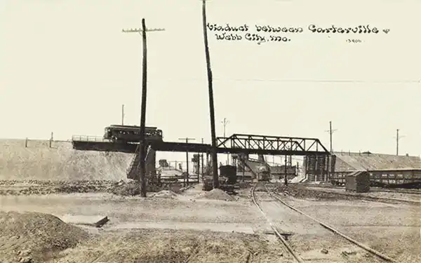
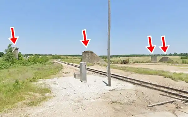
This viaduct was built in 1906 by the Southwest Missouri Railroad Company, established in 1893 and was the main means of transport in the area. However, 1926, when Route 66 was created it had already began using buses instead of streetcars. It ran next to U.S. 66 in many locations.
Centennial of Route 66
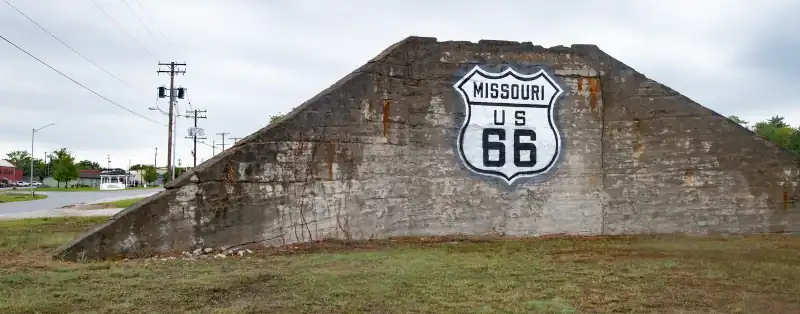
The city has has added a new landmark on Route 66 ahead of the 100th anniversary of The Mother Road next year. A Route 66 medallion-shield was added to the concrete viaduct support. Learn more about the Route 66 Centennial (1926-2026).
Trolley - Streetcar
There is a restored original streetcar in Webb City, trolley No. 60, built in 1916 on the south tip of Main Street in King Jack Park beside the Chamber of Commerce (52 E Tracy St.)
Cardinal Park
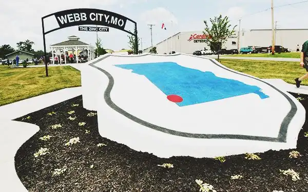
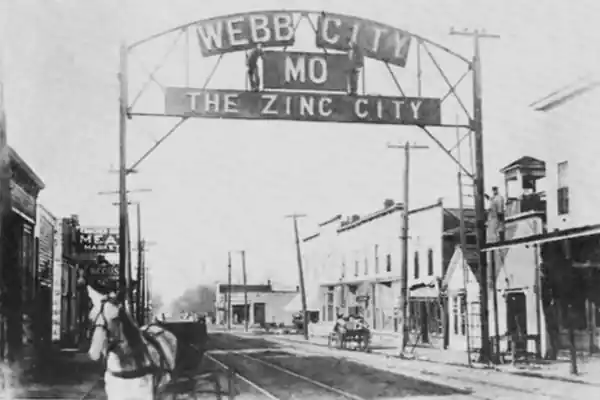
Ahead, Route 66 curves to the south and again to the west to enter the city. Here, at 528 E. Broadway St. is the 0.5 acre "Cardinal Park" (named after a local scale manufacturer that funded the park). It displays ancient mining equipment, a gazebo and a large "Route 66 Medallion" and a "Zinc City sign" that replicates the original one (more on this below).
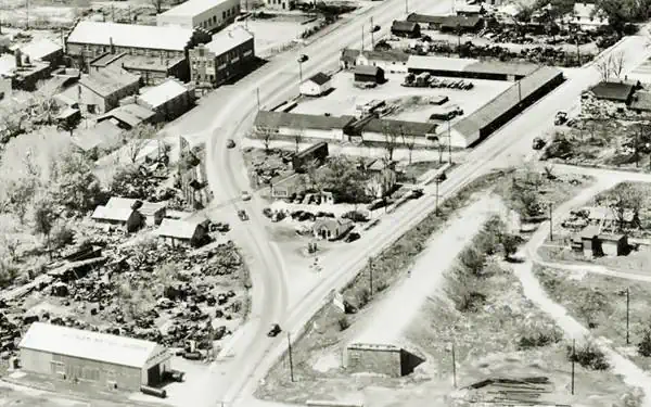
At one time there was a cottage-style gas station here (Daugherty St. station and garage), you can see it below, at the fork of Route 66 (that curves to the left) and E. Daugherty St. (to the right). On the upper left side is the "Webb Motor Truck Scale" factory, which is still standing there (View).
William H. Perry worked at Webb Corp., a company that manufactured large heavy-duty scales for industrial use and also mining equipment. He requested permission to develop smaller scales for weighing trucks, Webb Corp. agreed and they marketed his products. Perry founded Cardinal Scale Manufacturing Co. was founded in 1950 and by 1956 he resigned from his job in Webb and became a full-time entrepreneur.
An early 1900s picture of the "Zinc City" sign in Webb City.
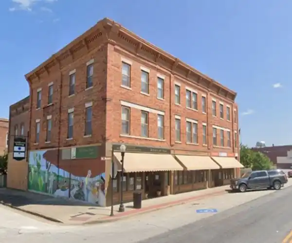
Head west along E. Broadway St. (Route 66) into the "Historic District". On the SE corner with Main St. is the old hotel mentioned by Rittenhouse.
Downtown Webb City Historic District
Listed in the National Register of Historic Places
Centered on Main and Broadway, it spans two blocks north and south along Main St., and comprises roughly one or two blocks east and west of it, along Daugherty and Web, bound by Austin St. (north), First (south) Liberty (west) and Tom (east).
It has many one to three story red-brick buildings built between 1883 and the mid 1900s. in different styles; from Italian Renaissance Revival to Art Deco, and even Queen Anne style.
You can park your car and take a walking tour starting at Broadway and Main St.
Middle West Hotel
Listed in the National Register of Historic Places
At 1 S. Main St. (SE corner of S. Main and E. Broadway), it was mentioned by Rittenhouse in 1946 as the "Midwest Hotel".
Built in 1883 as the town's Grand Opera House it was remodelled in 1902. It is a three-story red-brick building that originally faced E. Broadway but was realigned on S. Main when the electric streetcar was built.The hotel rooms occupied the second and third floors.
Middle West Hotel, in Webb City. Route 66 runs along its north facade.
Head south (left), half way down the second block at 24 S. Main, on the western side of Main is the "Movie Theatre".
Route 66 Movie Theatre

Route 66 Movie Theatre. Source. Click for St view
The two story building with Art deco style with a neon sign on its marquee it dates back to 1928.
Originally part of the Newland Hotel which partly burned in 1925, in 1945 it became the Dickinson Movie Theatre. Later Dixie and Larsen bought it, and it became the Larsen Theater.
The town grew smaller, audiences vanished and the place closed. It reopened in the early 2000s as the Route 66 Music Theatre with live shows, and again in 2005, purchased by the Hutsons. Return to Route 66. On the next block (N. Main and Daugherty) is the old "Miners Bank".
Unity Building and Merchant and Miners Bank
114 N. Main Street. Built ca. 1906 it is a three-story corner building built in light brown brick which housed a bank and a jewelry store. Notice its rounded corner and stone cornices. You can see it in both "Then and Now" images at the top of this page (to the left).
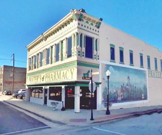
Across Daugherty on the NW corner of N. Main St., is the "Pharmacy" in the Wright Building.

Pharmacy
101 W. Daugherty. It is a two-story brick building from 1899, that has always been a Pharmacy. It began as the Jackson Drug Store. Notice the mural on its eastern facade, facing North Main St., painted by the city's Mayor John Biggs in 2010. It is 16 ft. wide and 8 ft. tall. The old pharmacy can be seen in the 1913 postcard (behind the streetcar).
Across Main, on the NE corner of E. Daugherty was the 1930s Bradbury-Bishop Deli and Soda Fountain, now closed.
Head west along W. Daugherty and on the SW corner of N. Webb is a mansion.
Aylor House
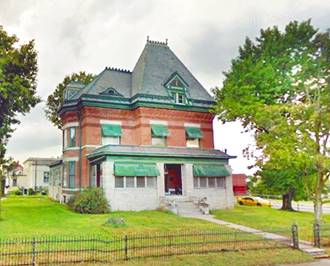
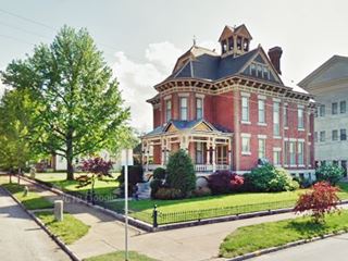
At 128 N. Webb, and W Daugherty, to your left, is a two-story Queen Anne style home built in 1890 by Joseph Aylor, a local businessman. It has a steep pitched roof, chimney, and towers (see picture above). On the same block, but on the north side of the road, to your right, is a former theater.
Civic Theater
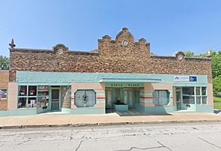
215 W Daugherty, pictured below. This theater was built in 1931, a one-story building with a strange combination of styles (Art Deco, Streamlined Moderne and Spanish Mission).
The U.S. Filling Station
On the corner, to your right (Liberty and W. Daugherty) is the "U.S. Filling Station."
Listed in the National Register of Historic Places
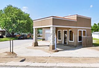
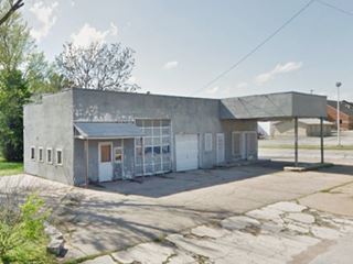
Nowadays it has been restored and repurposed as a commercial building (picture above) and this has altered the pillars that support the canopy (at one time they were Doric columns), but a few years ago it still retained its original "filling station" look as you can see below and still bore the words "U.S. Filling Station" on its western facade.
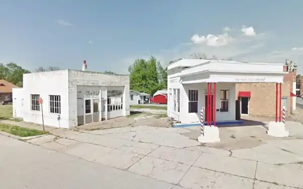
The building dates to ca. 1920 and was the gas station of the U.S. Post Office, and served the vans and cars that moved the mail in Webb City. The Post Office was located across the street. It was the only post office in the U.S. to have its own filling station.
It had a garage built next to it in the 1940s to repair and service the postal fleet. Later it sold Sinclair and Tydol gasoline and finally became a hair salon, and a used car dealer.
Site of Sinclair station
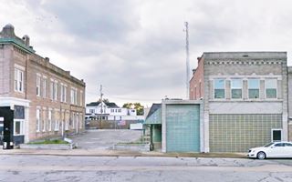
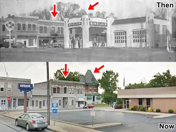
Retrace your steps back to Route 66 and continue your western course. On the first street west of Main (N. Webb St.) route 66 takes a sharp turn left. A Sinclair service station occupied what is now the parking lot of the U.S. Bank, on the NE corner of Webb and Broadway, to your right. The "Then and Now" image shows the site as it looked in the 1940s, and today. The red arrows mark extant buildings that helped us pinpoint its location.
The Sinclair station on N Webb and Route 66 in Webb City, in 1940 and now (gone).
Civic Cafe Drive In
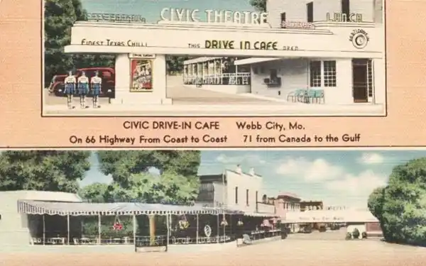
On the western side of the intersection, is the "Professional Plaza" (112 N Webb). Long ago it was the "Civic Drive In Cafe".
It faced Route 66 and the original two-story building on the north side of the property is still there, as well as the large parking lot. The sign across its entrance facing Route 66 is gone. The postcard below shows it during its heyday, the upper image looks westwards from Route 66, the bottom one looks east from the back of the cafe, towards Broadway. In both "Then and Now" images the original building is on the right side.
1950s Gulf Service Station
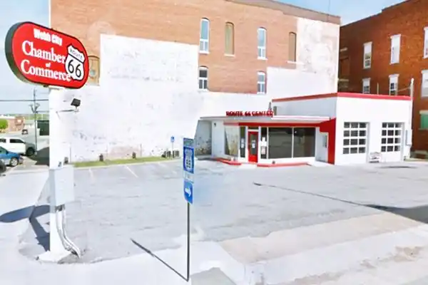
At the intersection, on the SE corner, to your left, is an old service station that is now the "Route 66 Welcome Center" (112 W. Broadway and Webb).
This was until recently an abandoned gas and service station that had been built in the 1940s. It has been restored (and its leaking oil tanks and soil pollution remedied) and is now the Webb City Route 66 Welcome Center.
The office has a flat roof with angled (inward sloping) eaves. The building doesn't have a canopy. It has a stepped design (service area is higher than the office); two multi-window service bays. It has an agled dooway on the corner of the office a feature used by Sinclair (1950-60), Texaco (1930-60) and Gulf (1940-60). We believe that this was a Gulf station.
Former 1950s (Gulf?) Service Station, now the Webb City Route 66 Visitor Center
Webb Mansion
Head south along Webb and take a right at the first corner following Broadway, on the next street, to your left, on the SW corner of W Broadway and S. Liberty St. is a two story gable roof mansion. This was the home of Elijah Thomas Webb (son of the city's founder), it was built around 1907. It is depicted in Pharmacy's mural, and pictured below.
Webb City Filling Station
Continue west along Route 66 until you reach Jefferson, here the highway turns south (left). Facing you, on the SW corner is another vintage gas station. Box-like, low and long with a flat canopy over the now empty pump island. Corner office and one extant service bay. It has the style of a 1940s service station (Some sources say it was built in 1929). See picture.
Continue south and when you meet MacArthur Dr. to your left is another "oldie" station, with three service bays (Street view). Route 66 continues straight on the other side of MacArthur Dr., but its median cuts off the original alignment, you will have to take a small detour (as shown in this map) to cross to the south side.
It carried on straight south, along S. Jefferson St. and then curved onto S. 14th St. to reach S Madison St. and head towards Joplin as shown in this map south of MacArthur Dr.
1958-78 Route 66 in Webb City
In 1958 US 66 was realigned together with US 71 along what is now I-49 BL (MacArthur Dr) from Madison St. in Webb City eastwards beyond Carterville. See this 1958-78 US 66 alignment map.
In 1978 Route 66 was decertified in Illinois and in most Missouri. Its eastern terminus was relocated 8 miles east of Joplin in Scotland, MO.
Short Side Trip east along 1958-78 US 66
Take a short 2 mile round trip detour (map) to visit two landmarks.
Old gas station
There is another old gas station next to the town's water tower, an oblong box with two service bays, no canopy, but the pump island is still there. The office has an add-on hipped roof. Pictured below.
The Praying Hands - a giant sculpture
On W. Tracy St. in King Jack Park. The statue of two praying hands is the work of local artist J.E. Dawson, who built in between 1972 and 1974.
It is 32 feet high (9.8 m) and weighs 100 tons. It consists of a stucco covering plastered over a steel frame. It is emplaced on top of a 40-foot hill. The pedestal reads: "Hands in prayer. World in peace".
There is another Route 66 sculpture of praying hands in Tulsa, Oklahoma.
Here in the park, you can enjoy a ride in the local Streetcar.
Your city tour of Webb City ends here, you can continue your road trip by heading west towards Joplin.

Sponsored Content
>> Book your Hotel in Joplin


Credits
Banner image: Hackberry General Store, Hackberry, Arizona by Perla Eichenblat
Jack DeVere Rittenhouse, (1946). A Guide Book to Highway 66.
Architectural - Historic Survey of Route 66 in Missouri, Maura Johnson. 1993.

