Oldest Mining Town in Southeastern Kansas
Route 66 American flag by WolfPack Photography
Index to this page
About Galena, Kansas
Facts, Trivia and useful information
Elevation: 900 ft. (275 m). Population: 2,790 (2025).
Time zone: Central (CST): UTC minus 6 hours. Summer (DST) CDT (UTC-5).
Galena is located in Cherokee county, in the southeastern tip of the state of Kansas and Old Route-66 runs through the town with an east to west alignment.
Galena's History
Kansas has been inhabited for around 10,000 years. Following the discovery of America, Spanish explorer Francisco de Coronado crossed the region in 1541. It later became part of the French Louisiana and was purchased by the US in 1803.
It is set at the foot of the Missouri Ozarks, in an area that was wooded and set apart as the Cherokee Neutral Lands for the Indians, however it was quickly settled and Kansas became a state of the Union in 1861. There were bloody skirmishes along the border during the Civil War.
Galena, the name
The word "Galena" is used to name the world's most important ore of lead. Galena is a lead sulfide mineral, which is the most abundant and has been mined for millennia. It is an appropriate name for a town that sprung to life to mine lead sulfide mineral (which also contains traces of silver).
The town was laid down by the Galena Mining and Smelting Co. and named "Cornwall". But it was initially known as "Short Creek", after a nearby stream. It was later known as "Bonanza", but the lead ore prevailed, and it got its current name in 1877: "Galena".
Galena's history began in 1871, when the railway was built through what is now Galena. But only in 1876 did the town appear, when mineral containing lead was discovered in the area. It was incorporated in 1877 and is the oldest mining town in Kansas.

Galena lead mineral. Rob Lavinsky
Lead mining brought prosperity to the region and its population reached 30,000 in the early 1900s. Route 66 was laid down through Galena in 1926, incorporating a former mining corridor road; Route 66 added to its prosperity. The segment through Kansas was fully paved by 1929.
During the Great Depression, there were several strikes by United Mine workers, which were subdued with the intervention of the National Guard. During the 1970s, Interstate I-44 bypassed the town entirely; cutting the flow of travelers and the mines became exhausted. This lead to a continued decline and a drop in population.
In the following image you can see cars coming from the left (west) along Route 66, turning north into Main St. (also Route 66) in downtown Galena.
Vintage colorized photo from the 1940s, looking North across 7th St. along Main St. in Galena.
This is where Route 66 curved into Main St

Same place today: Looking North across 7th St. along Main St. in Galena.
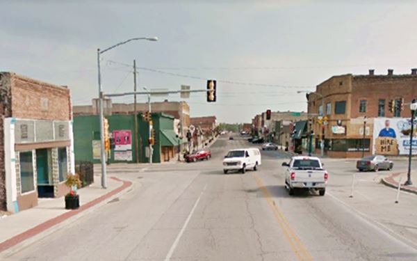
Many of the red-brick buildings have been torn down, but quite a few have survived. You can see them in both photos.

Trivia: Galena and Grapes of Wrath
Two of the characters in the Pulitzer Prize winning book The Grapes of Wrath written by Nobel Prize winner John Steinbeck, were from Galena: Sairy and Ivy Wilson.
Hotels in Galena
Where to Stay
> > Book your hotel in Galena
There are several hotels close to Galena; you can lodge in the neighboring towns in Kansas, Missouri or Oklahoma:
In Kansas Along Route 66
>> Check out the RV campgrounds in neighboring Baxter Springs
Weather in Galena
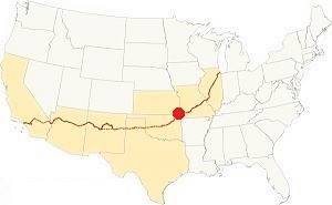
Location of Galena on U.S. Hwy. 66
The average temperature in Galena is 60.4°F (15.8°C). The summers are hot, with July averages of: 80°F (26.7°C) and average highs and lows of: 91 and 70° respectively (32.8 and 21.1°C). Winter temperatures average 45.7°F (7.6°C), with January average highs and lows of: 45°F and 25°F (7.2 and -3.8 °C).
Rainfall is quite constant, the monthly average extremes of 2.6 inches in winter (66 mm) to 5.4 inches in spring (160 mm). The average is around 8 to 9 days of rain or drizzle per month.
Snow does fall in winter, averaging 12.5 inches (32 cm). It falls between November and March, with peaks of around 5 inches (12.5 cm) per month in Dec and January.
Tornados. Galena is part of Kansas, and it lies within the infamous "Tornado Alley. Read more: Tornadoes on Route66.
Map of Route 66 in Galena, KS
See the detailed alignment in our Route 66 in Kansas webpage.
Below is the interactive map of Route 66 in town.
>> Map of this segment through Galena
Check out Galena on our Route 66 Map of Kansas, with the complete alignment and all the towns along it.
Map with the alignment of Route 66 through Galena
See this a map with the "classic" US 66 alignment in Galena. Later in the mid 1940s it was also routed along East 7th St.
Route 66 across Kansas
Historic U.S. highway 66, "Route 66" has been designated as an All-American Road and National Scenic Byway in the state of Kansas.
It was aligned in 1926 along pre-existing highways, as you can see in the following map published in 1924, two years before Route 66 was created. The road marked (2) is Jefferson Highway, and (50) is Ozark Trails.
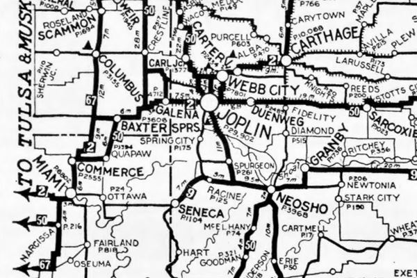
Route 66 Alignment near Galena
Visit our pages with old maps and plenty of information of the old US 66 roadway.
- KS-OK state line to Vinita (next)
- Route 66 in Kansas (Galena's)
- Springfield to Joplin (previous)
Sights and Attractions in Galena
What to Do, Places to See
US 66 in Galena: a historic context
Just after the end of World War II, Jack DeVere Rittenhouse drove the whole of Route 66 collecting information for his famous 1946 work, "A Guide Book to Highway 66". He mentioned each of the towns along Route 66 and dedicates the following comment to Galena.
garages: Phipps and Front St.; small hotel; no cabins; stores; gas; cafes. A town whose growth seems to have slowed. The main street has many old buildings, whose rofs are edged with the old-fashioned ornate metal cornices... Rittenhouse (1946)
The original Route 66 (the 1926 - 1961 alignment) is the continuation of Missouri's "Old Route 66 Boulevard", which in Kansas is renamed as "Front Street". This road enters the town from the northeast.
The current US 66, which crosses the town further south, as 7th Street, is the later (after 1961) alignment.
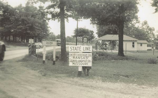
State Line
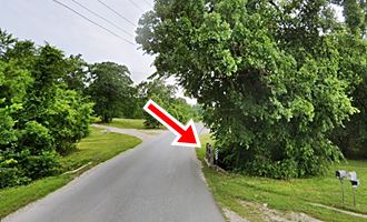
We will begin our tour on the state line just northeast of the city. As you cross the border an old bridge over a creek, affluent of the Spring Branch, built with the 1926 alignment is still standing (red arrow in the picture).
The service stations at the state line in Kansas, have all gone. Both images are looking west along Route 66.

US 66 bike Route
Source
U.S. Bicycle Route 66
You will see the sign just ahead. The US Bicycle Route 66 was created in 2018, it was formally designated as USBR 66 by the AASHTO.
It currently
exists in Kansas and Missouri Between Baxter Springs KS and St. Louis MO, spanning 358 miles (576 km).
It has its own official signage -white on a green background with a bike included and the number 66. See the picture.
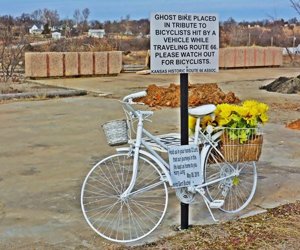
Ahead, at the Kansas Historic Route 66 Association stall there is a "Ghost Bike", painted white (pictured below).
It was placed there by local residents in memory of two German cyclists killed in an accident just west of Galena. Heinz Gerd Buchel and Harry Jung in their seventies were embarked on a Route 66 bycicle tour. Their journey was cut short on May 8, 2018.
Take-home point: Share the road.
Ghost Bike Route 66, Galena
Continue westwards, as you enter the town along Front St. you will see the mining roots of Galena. At the first sharp curve along Front St., as it meets the railroad. To your right, beyond the tracks, you can see the old smelter at the Eagle-Picher facilities which operated between 1912 and the late 1970s. Here the lead ore was processed and silver, zinc and lead obtained.
The factory was also the site of the bloody faceoff between trade union workers and the National Guard in the 1930s.
Hell's Half Acre
In the past it was known as Hickory Flats, and later as "Hell's half acre"; it had been perforated by countless mine shafts and waste ore from the mines known as "chat". In 2006 it was bulldozed and covered by EPA, but is undermined due to the mineral that was removed.
Historic Viaduct Front St. Bridge
After the curve, the road crosses the railway using the Historic viaduct built in 1923. It is over 200 ft. long, and meets the town's Main Street, turning south along it.
The bridge predates Route 66 by three years, and was built to carry Jefferson Highway. It was chosen to become part of its alignment when the Mother Road was created in 1926. It was a safe way across those busy railroad tracks.
The bridge's pillars were repaired in 2010 and the roadwork and deck were restored in 2017.
At the foot of the bridge, to your right is the Muffler Man and the Kansas Historic Route 66 Association building with several US66 attractions.
Kansas Route 66 Association
At 119 N Main St., to your right.
Frecs, the Muffler Man
This 19-foot tall "muffler man" (which, of course isn't a muffler man), was built by Renee Charles because there were no muffler men on Route 66 in Kansas.
He named it "Frecs", short for Freckles, after his miner grandfather. It is really big!
Learn more about the other Muffler Men on Route 66
The building next to it has quite a few eye-catchers like the "Sheriff Car on a Pole".

Frecs 19 foot-tall statue
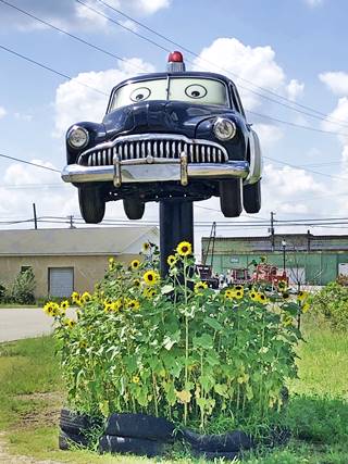
Sheriff from "Cars", Source
Police Car
The car on the top of the pole is a replica of one of Disney-Pixar's Cars franchise characters, "Sheriff". The original movie character is a
1949 2-door police car with siren, speaker and a red rotating gumball light (that lights up at night). The replica is a four door car, but other than that it is a great facsimile, painted
black and white and sporting the Radiator Springs Sheriff Department seal on its doors.
The building also has a replica of "Luigi", another character from Cars. Luigi is the owner of Radiator Springs' tire shop. He is an Italian Fiat 500.
There are some murals and wall art at the site. Stop by and take some photos. There is even a small stretch of the yellow brick road and Dorothy's phrase from "The Wizard of Oz", "There is no place like home".
Continue west and at the crossroad where Front St. meets Main Street and turns south, there are three classic Route 66 sights.
Haunted Staffleback Bordello
To your right, on the NE corner of E Front St. and Main St. The gabled building which had fallen in disrepair was recently restored. In the 1890s it was a bordello or brothel owned by the Staffleback family. An apocryphal story says that some family members were convicted for the murder of one of their customers, and that the ghost of deceased haunted the house. It is pictured below.
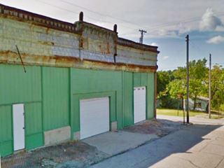
Across the street, on its western side is an old garage, pictured above.
Bradshaw's Front St. Garage
The garage was owned by August Bradshaw, he opened it in 1932 and ran it until his death in 1954. Rittenhouse mentioned it in 1946. Below is a colorized 1941 photo of Bradshaw's Front Street Garage.
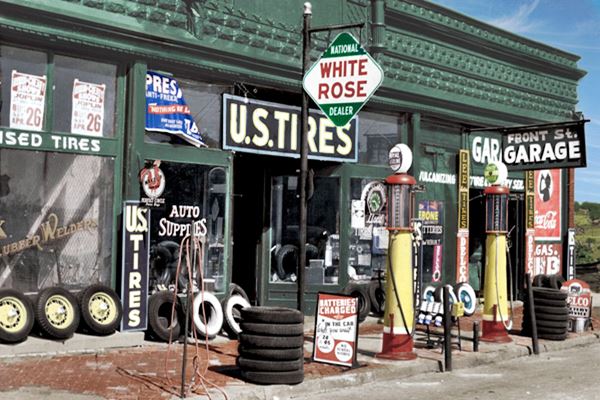
As you can see, at that time it sold White Rose Gas and U.S. Tires.
Ghost Signs
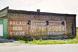
It is falling into disrepair but there are plans to restore it. The building dates back to 1896 as you can read on the cornice above its main entrance with the words Smith and Moeller. It originally served as a as a construction supply business and lumber yard owned by Louis Moeller and Joseph Smith.
The north wall of the building, has Ghost Signs. A Ghost Sign is an old hand-painted advertisment that has survived on a building for a long time and not been removed or painted over on. Ths ones at Bradshaw's read "J. H. Smith Lumber Yard" and "Palace Drug Store" - The drug store has long since closed, it was on Main and 6th St.
Old Kan-O-Tex service station
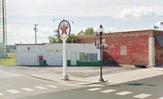
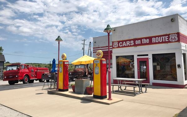
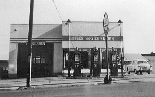
Across Route 66, to your left is the famous "Kan-O-Tex" service station at 119 North Main St. It is pictured below.
A 1950s photo when it was known as"Little's Service Station" (gas for 23 cents a gallon!)
Logo of the Kan-O-Tex brand of gasoline
The service station dates back to 1934. At one time it was "Little's Service Station". It sold a regional brand of gasoline in the states of Kansas, Oklahoma and Texas, and this gave it its name: Kan-O-Tex. The brand's logo was a sunflower set behind a five-pointed star. The company is now defunct.
It was built on the site of the Banks Hotel, on the Main Street in Galena (at that time it was U.S. Route 66). A few years later, a repair shop and garage were added.
The new four-lane US 66 highway moved to 7sth St. in 1961, leaving the service station far from the flow of travelers. When I-44 bypassed the town (and Kansas) it went out of business until it was restored in 2007. The restored site has a roadside café and a souvenir shop. It still has the facade and gas pumps but includes a diner which the original did not have.
It was previously known as "Little's Service Station, "4 Women on the Route and now "Cars on the Route", due to the boom truck that inspired a character in the movie Cars.
Cars Movie character "Tow Mater"
There is another tow truck in Pixar's animated movie Cars, "Tow Mater" was inspired by a truck which can be seen next to the service station. The truck (a boom-truck, which was used to lift gear from the mine shafts near Galena), was an L-series International Harvester 1951 model truck.
This series of trucks was introduced in 1949 and replaced in 1952 by the R Series. To avoid infringing Disney ⁄ Pixar trademarks, the original truck is named "Tater"
Heading into Downtown Galena on US 66
Buck's and Prehm's Pepsi Mural
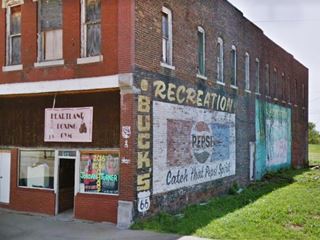
Drive into town along Main Street, at 214 and 212 N. Main, to your right is a large red-brick building, from 1895. It houses "Prehm's", at 214 a mercantile store that has murals of Pepsi and Mountain Dew on its north wall, and "Buck's" which was John Gill's store. it later was a Pool Hall in the 1940's.
On the next block (320 N Main St.), to your right is the Old Maywood Theater, built before 1918 as a movie and vaudeville theater (St. view).
Kansas Route 66 Historic District-East Galena
Main Street, Galena, KS.
Listed in the National Register of Historic Places
The classic red-brick buildings of an early 1900s American city along the original Route 66 alignment, they stand just as Rittenhouse described them in 1946.
The building to your right on W 4th St. was the First National Bank, and has more "ghost signs" (Selz... candies and soda water).
On the NE corner of 5th and Main is the former Miner's & Merchant's Bank, later named Citizens State Bank of Galena, now a Deli, it is believed to have been robbed by Bonnie Barrow (of Bonnie and Clyde fame), see its St. view.
Brown's Standard gas station
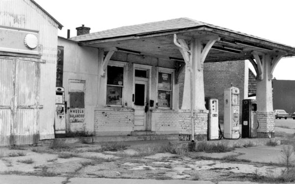
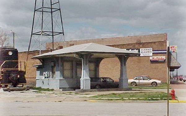
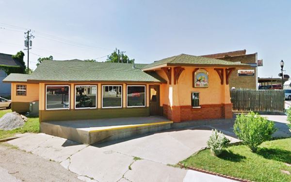
Opposite the bank, on the NW corner is what at one time was Brown's Standard service station. This is a late 1910s or early 1920s style station, with a Low-pitched hipped roof over the office that projects as the canopy. Stuccoed brick columns with tapered pedestals and wood brackets supporting the canopy's eaves.
The old building later had a lateral garage bay added. It was then reformed, the area under the canopy has been enclosed, but the old brackets and brick pedestals can still be seen. Below are some Then-and-Now pictures.
A 1980 photo of Brown's. It had closed in 1970.
A 2000 photo of Brown's. Notice that the garage bay has been removed.
Now Brown's is a Mexican Restaurant called "Mi Torito".
Howard "Pappy" Litch Memorial Park and the 1952 Will Rogers Marker
Across 5th St. facing Brown's gas station, at 502 Main St. During the late 1800s, a livery stable stood on this corner. Howard Litch turned it into a DX Service station (old postcard). Later it was a Federal Weigh station on the US Highway 66. The old garage building has been torn down and the property is now a park.
Howard Litch (1906-1996) was the son of a miner, a businessman and also a local historian who promoted Galena, the town's museum is named after him.
Galena's Jail
On the southern side of the park you will see a steel cage, a single-cell movable jail similar to the jail-cage in Foss Oklahoma, also on Route 66.
Route 66 Marker
Don't miss the "Official Route66 Roadside Attraction", the original 1952 Will Rogers Highway plaque now emplaced in
the park (it used to be on the Kansas - Missouri state line). St. view.
The marker's text is the following.
"Galena, Kansas Founded in 1877 Named for the Ore it produced, "Galena Lead" mining was the largest industry in our history, starting in 1873 and continuing until 1973. The mining and smelting required 3 railroads, 65 crushers, 2 smelters and 3 sludge mills to handle the ore produced from as many as 250 mines. The city sprang up with over 160 service and professional businesses. Its population grew to 30,000 people, making its history the largest community within Cherokee County. What today is known as "Main Street of America" or the "Mother Road", US 66 was established down our main street, Galena, Kansas, in 1926, dedicated as US. 66 Will Rogers Highway Dec 9, 1935. Kansas has 13.2 miles of Route 66 at this point there are 1794 miles west and 606 miles east of America's US Historic Will Rogers Memorial Highway US 66." "America is a land of opportunity and don't ever forget it." Will Rogers"
Will Rogers, Oklahoma's Favorite Son
William Penn Adair "Will" Rogers was born in 1879 close to Claremore, Oklahoma. He was a Cherokee Indian, a cowboy and also a movie star, an entertainer. He became a Brodway actor, a writer, philosopher and comedian. During his career in the 1920s and 1930s he made 71 movies and wrote over 4,000 newspaper columns. He was a world famous star. He died in an airplane crash in Alaska in 1935. Route 66 was dedicated to him.
Texaco Gas Station & Tag Flag
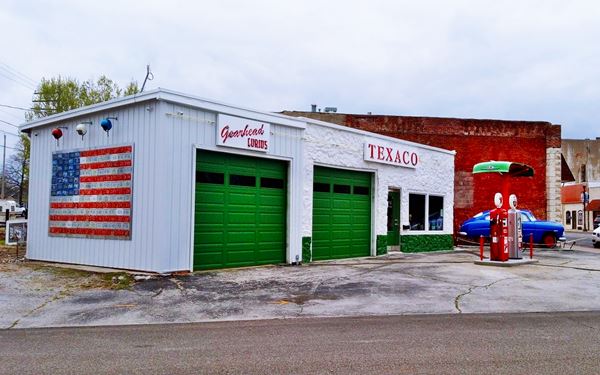
Beside the old Post Office, on the next corner (NW corner of 6th and Main), to your right, is a restored former Texaco gas station. Now it is a gift shop, Gearhead Studios, with artwork and curios for the Gearhead.
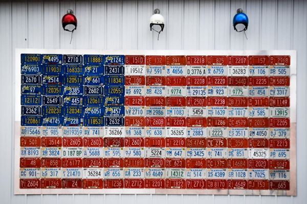
It also has a Disney-Pixar Cars movie character, "Doc Hudson" (Hudson Hornet, MD) in the role of a medical doctor and local judge in Radiator Springs. Don't miss the "Tag Flag" on its southern wall, an American flag made with license plates. This gas station was built between 1930 and 1946.
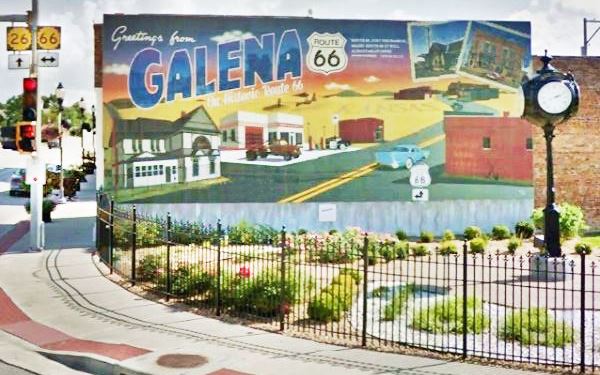
Murals of Galena
Ahead, at 7th Street on the SW corner of Main & 7th St. is the Mural. This is where the 1926 and the later 1961 alignments met in downtown Galena.
Then now empty southeastern corner is the site of the Sapp Opera House, built in 1896. It burned in 1931. Famous Harry Houdini performed there in 1898.
Coca Cola Mural

Coca Cola Mural. Source
The building on the northeastern corner dates back to 1897 and is known as "Schwartz building" it was a drug store. It now boasts a Coca Cola Mural along E 7th St. It is a nostalgia appealing mural 16 by 60 feet and is the work of Mythiq Art & Mural from Joplin MO.
Route 66 alignment on East 7th St.
East 7th Street became the only alignment of US 66 in 1961, but it had been part of Route 66 since the mid 1940s. Only one Route 66 site remains on this alignment east of town: Cornerstone Station.
Cornerstone Gas Station
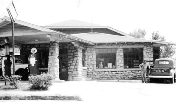
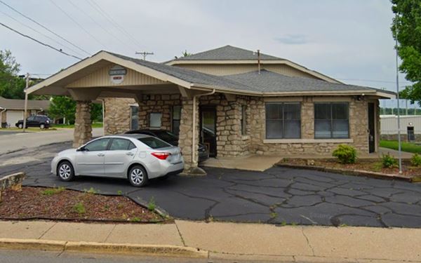
Turn left along East 7th, drive 0.4 miles, to your right at Wood and E 7th, you will see this stone building. With a gabled canopy over a now vacant pump island. Howard Litch built this station after he came back to Galena after serving in the army during WWII. The building from the late 1940s is still standing. Below is a "Then and Now" sequence.
Litch's Cornerstone gas station ca.1950
Litch's Cornerstone gas station nowadays
Turn around and head west along 7th, after passing Main St. you are on the original 1926 to 1985 alignment of Route 66.
Ahead to your left, on the SW corner of Short St. and W 7th is a former Gas Station from the 1960s, the canopy is clearly visible, the pump island and the old office and cafe or maybe garage bays (?); see St. view.
Litch Historical and Mining Museum
Ahead, to your right is Galena's Museum, at 319 W 7th St.
The museum is housed in the original building of the M-K-T railroad (Missouri-Kansas-Texas Railway) depot. It was acquired in 1983 for that purpose and moved from its original location on Main & Front Streets. The museum is named after Howard "Pappy" Litch.
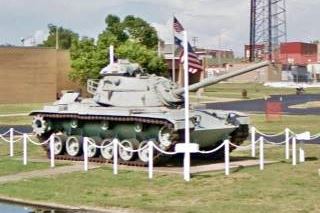
As fitting with a town born from mining, the museum has a collection of items related to the zinc and lead mining operations in the area; it also has a caboose and a locomotive and, the M-60 tank (pictured), form the US military. Across the road, to your left is an Old Gas Station:
Old Gas Station
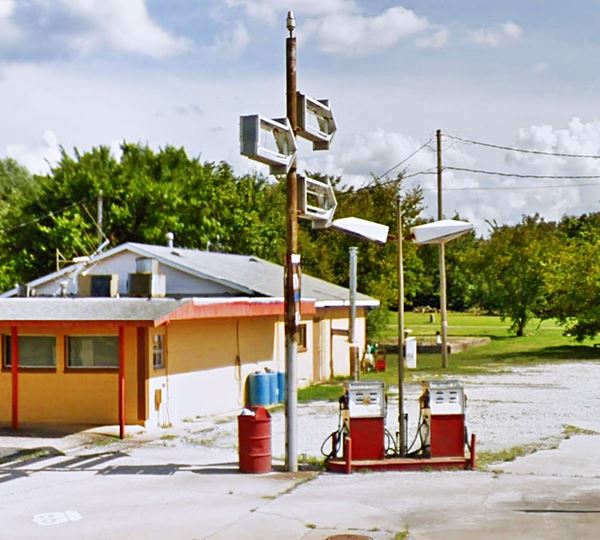
On the SE corner of W 7th St. and Elm. It has two pumps on the corner, no canopy and some signs with broken acrylic sheeting marking the spot.
This ends your City Tour along Route 66 in Galena.
Sponsored Content

>> Book your Hotel in Riverton

Credits
Banner image: Hackberry General Store, Hackberry, Arizona by Perla Eichenblat
Kansas Historic Route 66 Corridor Management Plan 2011
Jack DeVere Rittenhouse, (1946). A Guide Book to Highway 66.


